Chapter 2: Topography
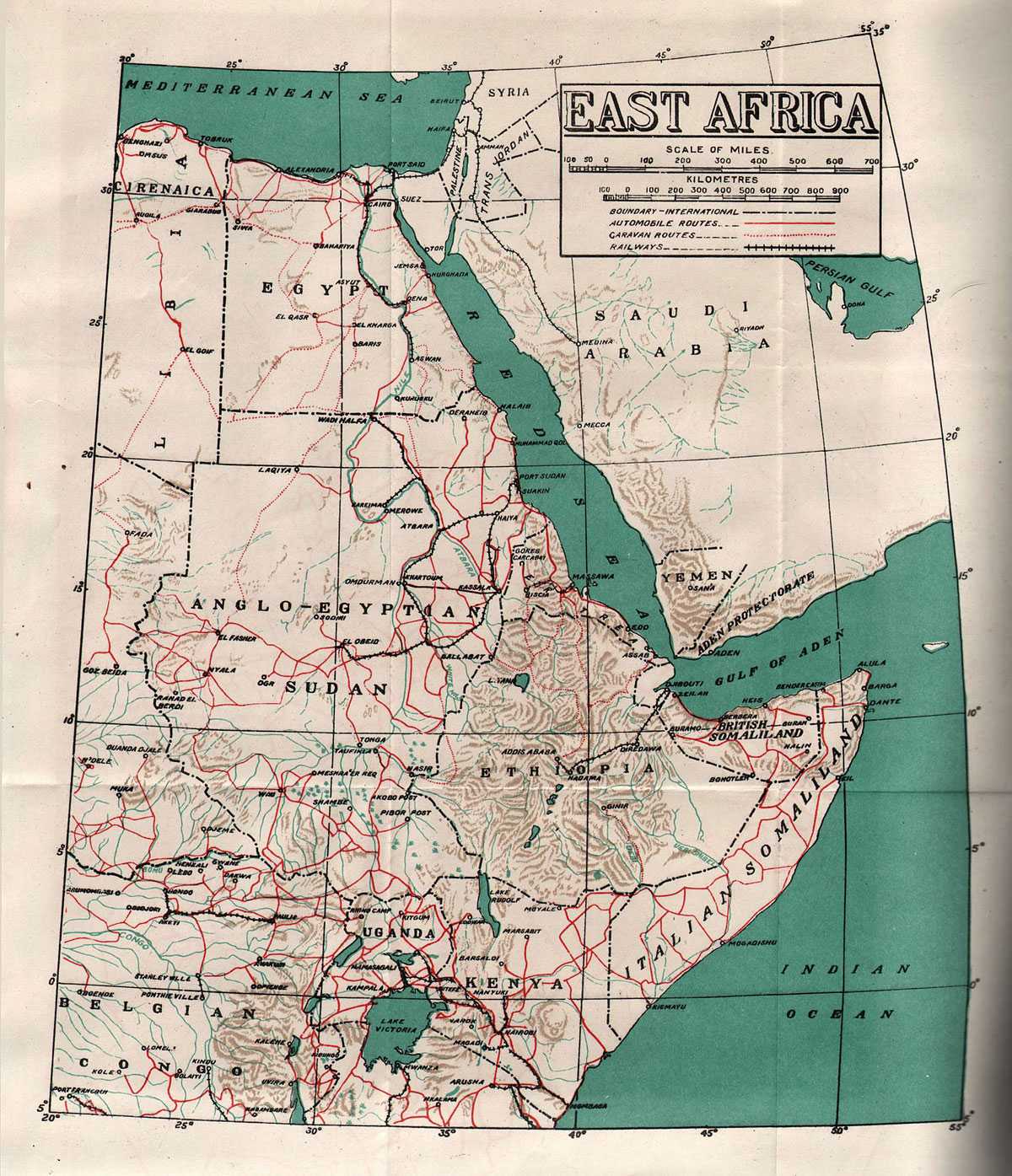
The area of operations in East Africa in which the Indian armed forces took an active part comprised the political divisions of the Eastern Sudan (east of the rivers Nile and Blue Nile), Eritrea, and Northern Ethiopia. The geographical and topographical aspects of these regions are given below separately.
Eastern Sudan
Anglo-Egyptian Sudan was a British protectorate which flanked the Italian possessions of Eritrea and Ethiopia. Geographically Eastern Sudan may be divided into three areas, the coast region, the northern region lying between the coastal region and the Nile and Atbara rivers as far south as Gallabat, where the Atbara crosses the frontier into Ethiopia, and the south-eastern region lying between the Atbara, the Blue Nile and the Ethiopian frontier.
The Coast Region
The coast region is a belt of sandy plain, frequently covered with low scrub, stretching inland from ten to twenty miles and traversed by Khors (water courses), generally dry, with ill-defined, shifting channels. Beyond this plain rise the mountain ranges with their slopes often bearing a considerable amount of vegetation. The climate of this area is generally hot and humid. There is occasional rainfall between August and January. The hottest month is July, when the maximum temperature at Port Sudan rises to 106° F, and the coldest month is February with a minimum temperature of 66° F.
Wind conditions in the Baraka Delta need special mention as they were likely to hamper operations in the area. With the exception of September, winds varying in speed from 40 miles per hour to 80 miles per hour normally blow during the day. The worst period is from mid-June to August when a wind, called “Baboob” blows from the south-west at 80 miles or more per hour. It blows continuously day and night making visibility almost impossible.
The Northern Region
In the north-east, bordering on the coast region, the Ethiopian plateau stretches northwards through Eritrea, with a steep eastern face and a gradual fall, in a series of terraces, to the west. In the north-west, this plateau yields place to small hilly ranges which
East Africa
are separated by wide valleys. The hills are between two and three thousand feet high. The valleys very often contain stretches of cotton soil in the wider parts, but they are rocky in the proximity of the hills. East of these hills is the plain watered by the inland river Gash. Farther south, a dry plain continues as far as the point where the Atbara crosses the frontier into Ethiopia. It is formed of cracked cotton soil, which is overgrown with high elephant grass. It is generally wooded with a few open spaces here and there.
The climate on the plateau is temperate and pleasant but the plains are hot and dry. The rainfall on the plains is generally very meagre, the southern parts getting comparatively more than the north. Kassala, in the Gash Delta, in the south, has an average annual rainfall of 13 inches. It is spread over the period from June to October. Water is to be found in the beds of Khors and in wells. The area of the Gash Delta tends to be highly malarious from July to October.
The South-Eastern Region
In the extreme north of this region there is a sand-stone plateau which is generally bare and level. Further south and to the west, the land is little more suitable for cultivation, though, here too, cultivation is practised in the valleys only. The remainder of this region is a huge plain, open and flat. During the rains it is used as a vast grazing ground. The rains last from June to October and there is a considerable difference in the average annual rainfall between the north and the south. This is illustrated by the following table:–
| Place | Latitude | Average rainfall |
| Atbara | 17° 40′ | 2.9 inches |
| Khartoum | 15° 36′ | 6.5 inches |
| Wad Medani | 14° 24′ | 15.9 inches |
| Gedaref | 14° 02′ | 27.0 inches |
| Gallabat | 12° 58′ | 35.2 inches |
| Roseires | 11° 51′ | 30.2 inches |
Except during the rains, the climate is dry. The summer temperature is high and even in winter the days are relatively hot. The maximum and minimum temperatures of Khartoum are tabulated below (°F):–
| Jan. | Feb. | Mar. | Apr. | May | June | |
| Maximum | 86° | 89° | 96” | 103° | 107° | 107° |
| Minimum | 59° | 61° | 65° | 72° | 77° | 79° |
| July | Aug. | Sep. | Oct. | Nov. | Dec. | |
| Maximum | 102° | 99° | 102° | 103° | 94° | 88° |
| Minimum | 77° | 76° | 770 | 75° | 68° | 61° |
Except towards the end of the rains the climate is generally healthy. The banks of the river Atbara are generally highly malarious during the period following the rains.
In the south and east very tall grass grows which makes visibility difficult.”
Communications
Ports
Port Sudan opens out on the Red Sea which provides it access to the world outside. But the coast line is neither extensive nor suited to the development of many ports. There were only two ports worth mentioning when the war started, Port Sudan and Suakin. The first was opened in 1908 and had a good average depth of ten to fourteen fathoms. It had five quays for berthing vessels and all the modern port machinery. The second, Suakin, was the old port of the Sudan. Its channel of entrance was gradually closing in owing to the growth of coral, and therefore it was not of much use.
Waterways
In the interior an important means of communication is the river Nile. Out of its total length of 3,526 miles, 2,130 miles lie in the Sudan. The nine hundred and sixty miles of the river in Egypt, from Damietta to Wadi Haifa is navigable. Of this the portion between Aswan and Shallal, is navigable through the Aswan Dam lock. The portion from Wadi Haifa to Khartoum in the Sudan, however, though navigable at high water, offers difficulties and is not free from risk. From Khartoum to Rejaf for over one thousand miles the river is navigable. The next hundred miles from Rejaf to Nimule do not admit of navigation.
Within the Sudan the Nile system of rivers consists of two elements. Firstly the flood rivers descending from the Ethiopian plateau, viz., the Blue Nile, the Atbara and the Sobat, which bring down a
great volume of water during the rains, but little during the dry season. The Blue Nile is navigable from Khartoum to Sennar, a distance of two hundred and twenty-three miles, from June to December. At Sennar, the Dam had no lock, therefore through service was not possible. South of Sennar the river is navigable (bi about six months, as far as Reseires, a distance of about one hundred and seventy miles. Above Roseires the river was not navigable. The two tributaries of the Blue Nile, the Rahad and the Dinder, had been navigated in the past, but there was no regular traffic on them. The river Atbara, which flows into the Nile at Atbara, about two hundred miles to the north of Khartoum, is not navigable except for small barges from mid-June to October as far as Sarsareib. The river Sobat, a tributary of the White Nile, is normally navigable from the beginning of April to the end of January.
The other element in the Nile system of rivers consists of the swamp rivers of the south and the south-west, namely, the Bahr-el-Jebel (the name generally given to the continuation of the White Nile south of Lake No), the Bahr-el-Ghazal and their tributaries, which contribute a comparatively small but constant volume of water throughout the year. The Bahr-el-Jebel is navigable as far as Rcjaf throughout the year. The Bahr-el-Ghazal is navigable throughout the year, for about one hundred and fifty miles above Lake No, where it joins the Bahr-el-Jebel. The Sobat, which joins the White Nile south of Malakal is navigable from April to January.
Railways
The railway system in the Sudan was a single line 3 ft. 6 in. gauge having one or more loop lines or sidings at every station. The main line began at Wadi Haifa, crossed the Nubian desert to Abu Hamed and then followed the right bank of the Nile to Khartoum via Atbara. South of Khartoum it followed the west bank of the Blue Nile to Sennar and then turned sharply to the west across the Gezira1 to Kosti, where it crossed the White Nile. From Kosti it took a more or less westerly direction to El Obcid. From Wadi Haifa to Khartoum is a distance of five hundred and seventy-four miles, and from Khartoum to El Obeid four hundred and twenty-eight miles.2 From this main line forked the following branches:–
i. From No. 10 station, sixteen miles north of Abu Hamed, a line ran south-west along the north bank of the Nile to Kareima. This line was about 138 miles long.
ii. From Atbara a line ran north-east to Port Sudan, first across the desert and then over the Red Sea hills. This was the most important section of the line in the Sudan, as almost the entire export and import trade of the country passed along it. It was two hundred and ninety-five miles long. The average time taken by passenger trains over this line was twenty-three and a half hours from Khartoum to Port Sudan and twenty-five hours in the opposite direction.
iii. From Haiya Junction, on the Atbara–Port Sudan line, a line ran south to Kassala and thence south-west to Geda-ref and west to Sennar, where it was connected with the main line. This line was four hundred and ninety-eight miles long. From Haiya Junction to Kassala the journey took eleven hours and the return journey about an hour longer. From Kassala to Sennar or back was a run of twenty hours.
iv. From Sallom Junction, on the Atbara–Port Sudan line, a short length of line ran south to Suakin, which was the chief port of the Sudan before Port Sudan was built. The distance was twenty-eight miles and trains took about one hour and a quarter to cover it.
Not connected with the main railway system was the Tokar–Trinkitat light railway. It was nearly 18 miles long and the gauge was two feet only. It was constructed in 1921.
All stations were inter-connected by telephone and certain stations were also connected by the railway telegraph system. This was in addition to the ordinary telegraph lines which were controlled by the Director of Posts and Telegraphs.3
Roads
There was only one metalled road in the Sudan, the Khartoum–Sennar road. It ran along the west bank of the Blue Nile. All other roads had mud surfaces and had to be rebuilt after the rains every year. In dry weather, the going across the country was good, the only obstacle being the tall elephant grass.
Eritrea
Eritrea was the next region where Indian forces were engaged in fighting the Italians. This country is triangular in shape with
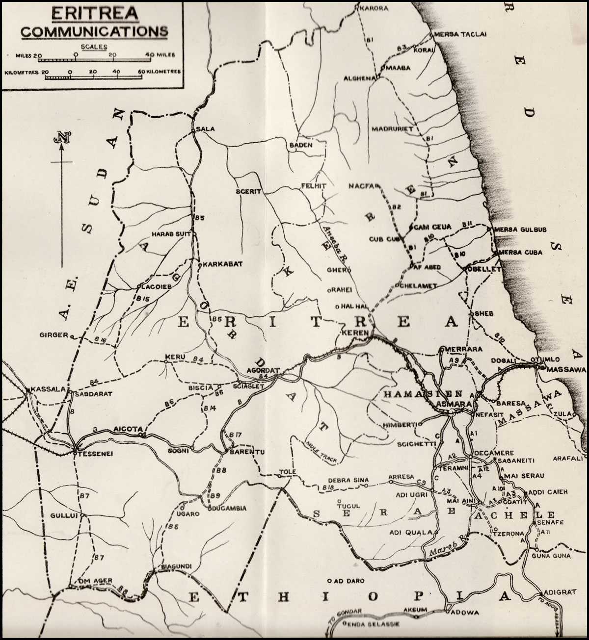
Eritrea Communications
a long projection in the south-east corner. The apex, at Ras Kasar, is a cape on the Red Sea coast, one hundred and ten miles to the south-east of Suakin. One side of the triangle is formed by the Red Sea coast and the other by the frontier with the Sudan which runs south-west from Ras Kasar to Om Ager. The third side of the triangle is formed by the frontier with Ethiopia and runs east from Om Ager. The projection in the south-east corner consisted of a stretch of the coastal plain, one hundred and fifty miles long and forty miles wide, which ran to the south-east as far as the boundary with French Somaliland.
The main region covered by this triangle is a plateau forming part of the Ethiopian table-land. It rises abruptly from the foothills bordering on the coastal plains in the east where its highest parts lie and where the general elevation is about six thousand feet and the highest hills above ten thousand feet. To the west and north-west, the plateau drops gradually, in a series of terraces until in the west, on the frontier with the Sudan, the general elevation goes down to about one thousand five hundred feet. The east coast consists of sandy country covered with bushes. It is frequently intercepted by water courses near which vegetation is somewhat richer.
Climate
The country may be divided into three distinct climatic zones.
The Coastal Region (Up to 1,650 feet)
This region is very hot and humid during most of the year. June, September and October are the hottest months. Massawa in this region has an average temperature of 88°, but the maximum in summer is 120° in the shade. Most of the rainfall is during the summer monsoon season. There are occasional showers in winter also.
The Zone of Escarpments and Valleys
This zone has a temperate climate with a considerable variation of temperature between day and night. It gets summer monsoon rains only, except areas bordering on the coastal region, where there is some winter rain also. May is the hottest month.
The High Plateau
It is moderately cool. Heavy monsoon rains occur from June to September with slight showers during April and May. The dry season from November to April is the hottest. Climate above 8,500 feet is distinctly cold, sub-alpine.
Communications
Eritrea was accessible from the Red Sea which provided its most important means of communication with the outside world. However, Massawa was its only port of importance. It was laid out on two peninsulas and three islands which complicated the system of communications within the town. Ships of 10,000 tons could enter the various basins, where port facilities included large petrol storage tanks. The town and the port areas each had a telephone exchange accommodating a hundred subscribers. There was an emergency wireless set also. Water for Massawa was pumped from wells at Dogali, twelve miles away for there was no good local supply. Food and fuel also had to be imported. The town was not capable of withstanding a long siege without large stocks of water and provisions. The population of Massawa comprised 3,000 Italians and 12,000 local inhabitants.
Railways
On land, Eritrea had no navigable waterways and there was a single railway line from Massawa to Agordat via Asmara. This railway was a single track line of the unusual gauge of 95 centimetres or about 3 ft. 1 3/8 in. and thus 5 5/8 inches narrower than the Sudan Railway. The distance from Massawa to Asmara was seventy-three and a half miles, and the railway climbed 7,900 feet from the sea level at Massawa to the highest point only one and a half miles short of Asmara. From Asmara to Agordat, one hundred and nineteen miles, the line dropped again to just under two thousand feet. There were two hundred and four arches of bridges of a total length of 2,230 yards and 4,950 yards of tunnels. Culverts were generally small, especially in the Ghinda–Asmara section. The winding track round the spurs of hill with frequent narrow culverts liable to landslides and blocked culverts in heavy rains made movement difficult.
Roads
Asmara, the capital, was the centre of land communications in the country. In addition to the railway, all major roads passed through this place. In Eritrea there were a number of trunk roads. The first was Sabderat–Asmara road. It was laid through Tessenei, Aicota, Barentu, Agordat and Keren. This route was one of the oldest in Eritrea, dating back to the early days of Italian colonization. It was built up to its modern standard in 1937-38. It was a wide (6-8 metres), graded and banked, all-weather road the whole way, with some fine bridges; but out of the total length of two
hundred and forty miles only the last eighty miles up to Asmara were tarred. The surface up to that point was, by contrast, definitely poor, consisting of small stones and earth, badly packed; and was very hard on tyres. But for its poor surface this section also had all the characteristics of a first-class road, including large kilometre posts and warning signs. It was the only all-weather road leading to the Sudan frontier which could carry heavy traffic.
Deployment off the road was usually possible, until just below Keren, but it was not easy, because all this region was badly eroded and the Khors were many and deep. The road provided poor facilities for cover. However, there were several sites on it which were suitable for effective demolition. The chief among them was the Dongolaas George below Keren. At several points the railway ran close alongside the road and both could be damaged by the same bomb or charge.
The next major road was that between Asmara and Massawa. This road was perhaps the most important road in Eritrea, as it carried by far the greater part of all- the goods imported into the country. The road was an old one, but it was rebuilt and modernised in 1935. It was a first-class road, eight metres wide. Of the eight thousand-feet climb from the sea level, seven thousand feet were compressed into the last thirty-five miles, and this section formed one of the most striking hill roads in the world. Long sections were cut out of the steep face of the escarpment. During the winter the hill was shrouded in thick mist, often for days on end.
Asmara–Decamere–Adi–Caieh–Ethiopian Boundary road was the third important route in Eritrea, owing to its approach to the Ethiopian borders. This road was built long before 1935, but like other main roads in the country, it was straightened, widened and tarred between 1935 and 1938, when it became a first-class road in every way. The road ran first over the high plateau near the Red Sea, and no big streams were crossed until south of Saganeiti, thirty-eight miles from Asmara. From there to Adi Gaieh it passed through much more difficult country and there were many vulnerable points. From Adi Gaieh to the frontier it kept along a narrow strip of plateau. Cover was poor along almost the whole route.
The fourth was the Asmara–Adi Ugri–Adi Ojuala–Ponte Mareb road. It was intended to join Asmara with Addis Ababa via Gondar. The Asmara–Gondar section had been completed before the outbreak of the war.
The next important stretch of the road serving as a bypass round Asmara for traffic coming from Massawa, and destined for
Southern Eritrea or Ethiopia, was that of Nefasit–Decamere road. It was a first-class road with a tarmac surface. It left the Massawa–Asmara road at Nefasit just as it began the steep climb up the hill. This road traversed an escarpment and passed through a very difficult country. Deployment was seldom possible and the road was very much vulnerable to air attacks and blocks. It was also liable to blocking by the fall of rocks.
In addition to these roads there were a number of motorable tracks in Eritrea which provided movement during operations. One of these was the track Sabderat–Wakai–Keru–Mogareh–Sciaglet–Agordat. This was a dry weather motor track which was used a great deal before the reconstruction of the main road via Barentu in 1937–38. Cover on this route was good and deployment easy almost anywhere. The defile at Keru was the only good holding place for defence.
The next, Aicota–Biscia–Sciaglet, was a well-defined but difficult track, crossing a great many Khors deeply cut, and sandy in patches. It passed through the three-mile-long Adal Gorge, at 23-25 miles from Aicota, where no deployment was possible as, although the gorge was not very deep, it had steep and rocky sides. The track was fit only for strong vehicles, but desert tyres were not essential.
Barentu–Tole–Debra Sina–Arresa track was probably intended to be a second east-and-west line of communication across the whole country; but it never assumed that position because of the difficult stretch between Debra Sina and Arresa, where it climbed on to the plateau. The route was however never completed.
The next track was Karora–El Ghena–Cub Cub–Keren, the chief importance of which lay in the fact that it connected the Sudan with Eritrea. From Karora on the frontier to Cub Cub, the route was a well-defined track, capable of use by mechanised transport. It followed the edge of the coastal plain, to the east of the foot of the hills and required little maintenance. Except during the rains, it could be used by vehicles properly equipped for desert work. Water was scarce along this route, but generally enough for a brigade, even in the driest season. Generally available in shallow wells or water holes, water was dirty and sometimes brackish, but quite drinkable in case»of necessity.
The section Cub Cub–Keren was along the third class dry-weather road from Nacfa to Keren. It passed through the hills and crossed many Khors and rivers. It was generally graded.
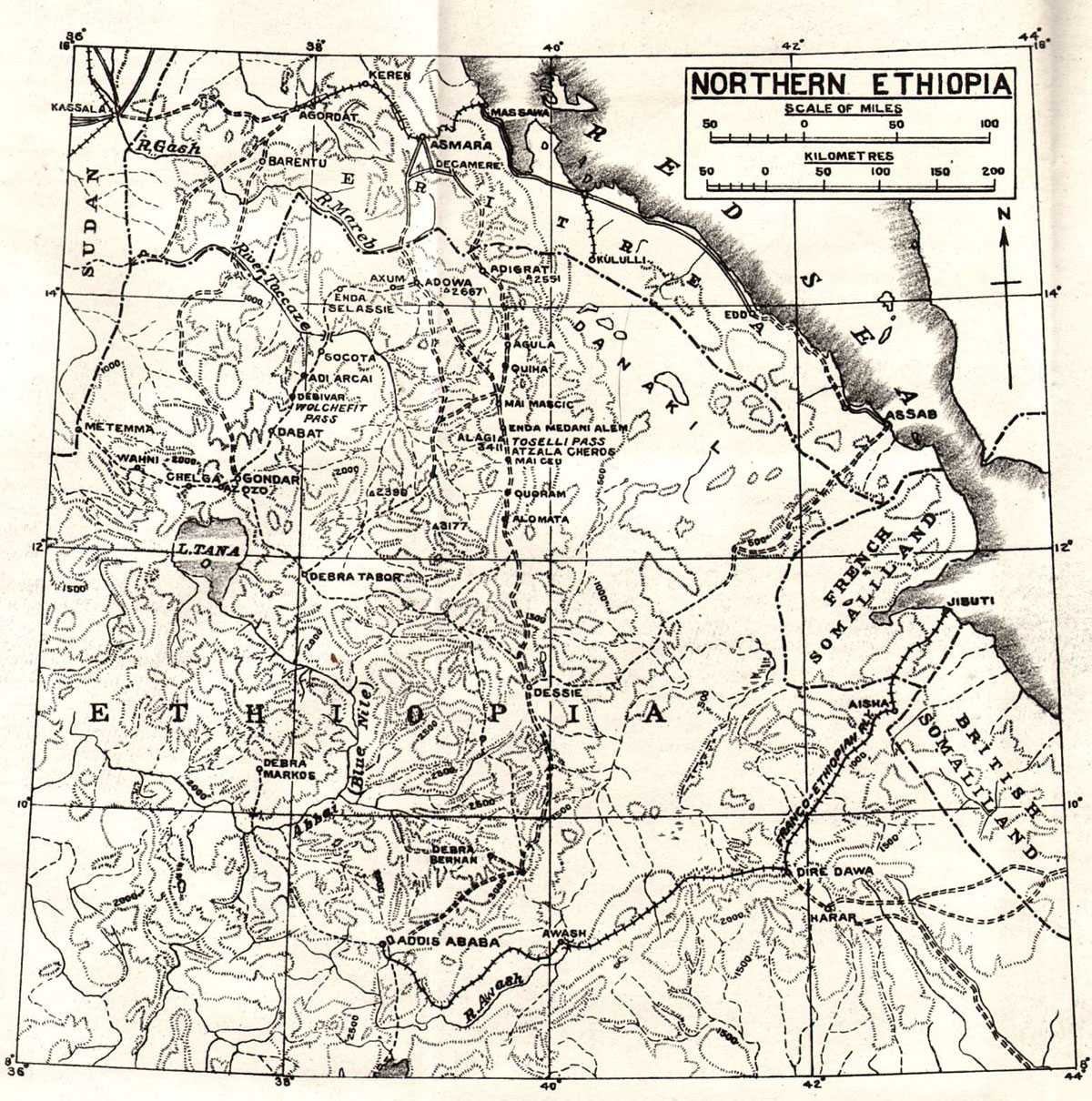
Northern Ethiopia
Ethiopia
Ethiopia was annexed by the Italians to their African dominion mediately before the war. Northern Ethiopia where Indian forces look part in fighting consists of a table land in the centre with an average height of six thousand feet, many of the mountain tops bring even higher. On the east this table land drops abruptly to the Afar or Danakil plain. To the west and north-west the plateau an falls in terraces to the plains of the eastern Sudan.
The climate of this region varies according to the situation of the area or its altitude. The eastern plain is hot and dry almost having semi-desert climatic conditions. On the table land it is temperate and healthy. The valley of the river Taccaze, lying north and south, about seventy miles to the east of Gondar, which debouches from the plateau, is tropical and malarial. The rains occur from June to September and average about thirty inches in the year.
Administration
In May 1936, subsequent to the Italian invasion and annexation of Ethiopia, the King of Italy was declared Emperor of Ethiopia, and the Italian colonies of Eritrea and Somalia together with Ethiopia were incorporated into a single state called Italian East Africa. The new state was subsequently divided into six provincial governments; Eritrea, Amhara, Socioa, Harar, Somalia and Galla Sidama. Every province was divided into districts, residencies and sub-residencies. In the six provinces there were in all 72 districts, 259 residencies and 65 sub-residencies.
Communications
In most mountainous countries river valleys are lines of communication and mountain ranges are barriers. In Ethiopia the opposite is true; here watersheds are lines of communication and rivers are barriers. This is because most Ethiopian rivers have cut deep gorges across an upland plateau. There are hardly any navigable rivers; they are to be regarded primarily as obstacles to communication and often very formidable ones too. Ethiopia had no openings on the sea.
Railways
The Franco-Ethiopian Railway ran from Jibuti to Addis Ababa. It was a single line metre gauge track. The distance from Jibuti to Addis Ababa was 491 miles; of this the first 61 miles were in French Somaliland. The railway was started from Jibuti in 1896,
railhead reached Dire Dawa in 1902 and Addis Ababa in 1917. The capacity of this railway at the time was about seven hundred tons daily, actually the maximum it had ever attained was four hundred tons daily in 1937. The most vulnerable point on this railway was the Awash River bridge at mile 339. If this were destroyed replacement would take a long time and would be very difficult. The next most vulnerable point was the tunnel at mile 114½. It was the only tunnel on the line but its destruction must cause considerable inconvenience.
Roads and Tracks
I. The Asmara–Addis Ababa road.
It was laid through Asmara, Decamere, Adigrat, Quiha, Mai Mescic, Toselli Pass, Mai Ceu, Quoram, Dessie and Addis Ababa and was 758 miles long.
This was a continuation of the Eritrean route from Asmara to the Ethiopian boundary described above. The Eritrean part of the road was built before 1935. It was extended to Addis Ababa between 1935–38. The road traversed a most difficult country. Its lowest point was 3,500 feet and its highest 10,200 feet. On crossing the frontier into Ethiopia it continued to follow the crest of the watershed, between the Mareb (Gash) and the Danakil depression, as far as Adigrat. From Adigrat to Mai Ceu it ran west of the watershed between the Taccaze and the Danakil. At Mai Ceu it crossed over to the east and at Debra Sina it crossed the watershed again and kept on the west, bridging the headwaters of several of the tributaries of the Abbai (Blue Nile) as far as Addis Ababa. Since the road followed the watershed pretty closely it did not have to cross any large rivers, an advantage however offset by the terrific climbs the road had to make. It was a first class road, eight to nine metres wide, of which six to seven metres were asphalted. The surface was asphalted throughout except for two stretches from mile 311 to 490 and from mile 525 to 678. Where the surface was not asphalted the road was covered with loose metal. At the outbreak of the war the road was in a very good condition. It was one of the most important trunk roads in Italian East Africa.
II. The Asmara–Gondar road, via Ponte Mareb, Adowa, Axum, Debarec.
The Italians considered this as one of the nine important main roads in Italian East Africa. It was a well-built road of the same standard as the Asmara–Addis Ababa road. The surface for the most part was macadam only, which was very loose in the hills. The road was a great engineering feat and was probably the most spectacular in the country. It had to climb the sheer face of the
mountains, 7,700 feet high before coming out on to the immense plain which sloped gradually to Gondar.
III. The Metemma–Gondar Road.
This route was opened as a motorable track in 1937. Economy was an important factor in its making and no macadamising or asphalting or any major road works were undertaken west of Azazo. It was simply a cleared motor track which was impassable during the rains. The road was not used between early 1938 and 1939 owing to a landslide which blocked the road near Wahni. Early in 1940, it was reopened after considerable hard work in the Wahni area.
In addition to the above the Italians had made comprehensive plans for making roads and in northern Ethiopia had built a major road from Assab on the sea coast to Dessie. They had intended to continue this from Dessie to Gondar. Of this road only a portion had been built-out of a total distance of two hundred and forty-five miles, ninety-three miles had been built at the outbreak of the war.