Chapter 5: The Plan of Assault
The choice of assault sites along the Mediterranean coast of France was in large measure dictated by the ANVIL operational concept—to land in southern France, seize and develop a major port, and exploit northward up the Rhone valley. Of these objectives, none imposed more tactical limitations on the selection of the assault beaches than the requirement for the early seizure of a major port. From the inception of ANVIL, Allied planners regarded the capture of Marseille, one of France’s major port cities, as vital to the success of the operation. Sete, eighty-five miles west of Marseille, or Toulon, thirty miles east of Marseille, or the many smaller harbors dotting the French Riviera could serve as interim ports, but only Marseille could handle the projected volume of logistical operations envisaged for southern France.
Selecting the Landing Area
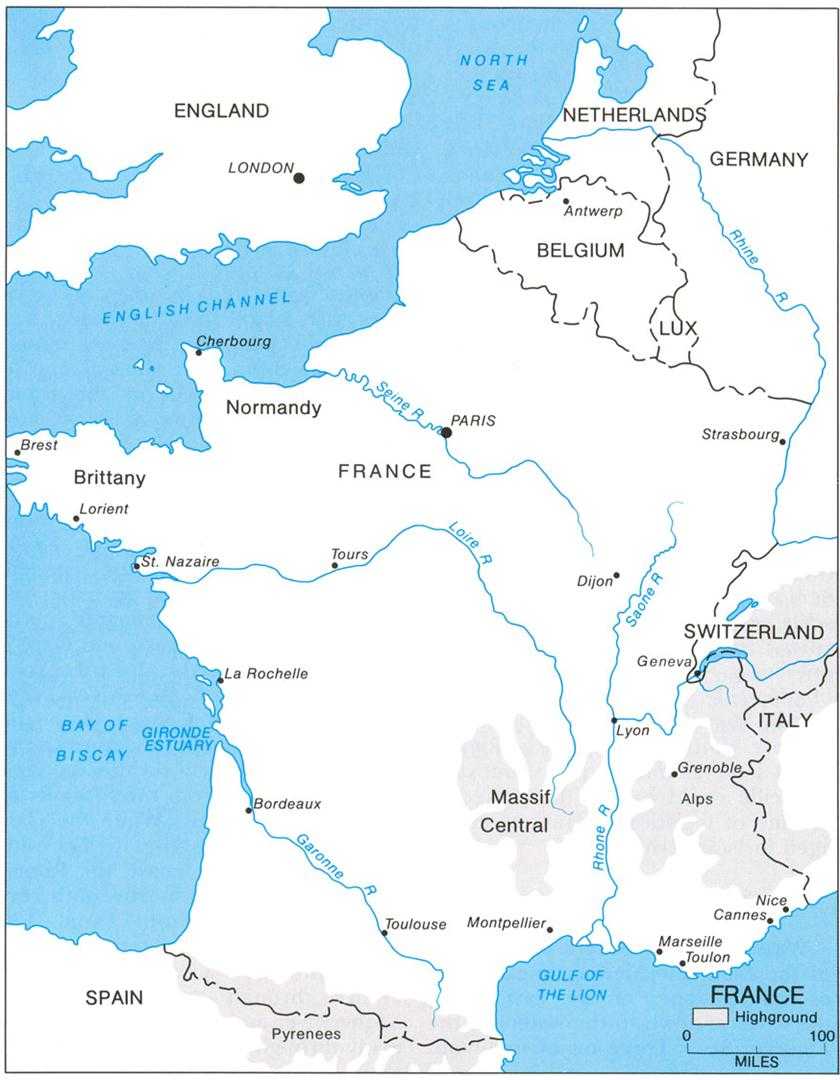
Washed by the waters of the Gulf of the Lion, the Mediterranean coast of France slopes on the east, along the Riviera, down to the waters of the Ligurian Sea.1 Three major mountain masses, separated by natural corridors, rise inland from the coast (See Map 3). On the west, the Pyrenees mountains, stretching from the Atlantic to the Mediterranean, form the traditional boundary between France and Spain; on the east, the Alps serve a similar purpose, separating France and Italy and defining the Swiss border farther north. Between these two mountain ranges and about twenty to thirty miles inland rises the Massif Central, a large mountainous plateau region that dominates southern France. The Carcassonne Gap, a valley area formed by the tributaries of the Garonne and Aude rivers, separates the Massif Central from the Pyrenees in the west; and the Rhone River valley similarly divides the central plateau area from the foothills of the Alps in the east. While the Carcassonne Gap links the Riviera with the French Atlantic coast, the Rhone valley is the historic north-south corridor of France. From Lyon, 170 miles north of the Mediterranean, the valley provides access to northern France through the valley of the Saone River and to southwestern Germany through the Belfort Gap.
Map 3: France
South of Lyon the Rhone flows through alternating steep-sided narrow valleys and more gently sloping basins. Some of the basins give way on the east to corridors penetrating deeply into the Alps. At Avignon, some forty miles north of the Mediterranean, the Rhone enters a broad delta that, with lowlands along the eastern shore of the Gulf of the Lion, forms an arc of flat, often marshy, stream-cut ground stretching from the Pyrenees almost to Marseille.
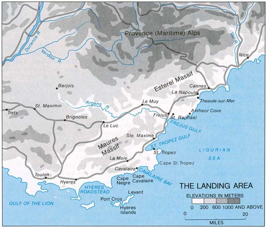
The mountains east of the Rhone and south of Lyon consist of westward extensions of various Alpine ranges. Those close to the coastal area are loosely known as the Provence or Maritime Alps. In addition there are two non-Alpine coastal hill masses northeast of Toulon, the Massif des Maures on the west and the smaller Massif de l’Esterel on the east (See Map 4). The Maures massif extends inland nearly twenty miles; the Esterel scarcely seven. The Argens River valley separates the Massif des Maures from the Provence Alps to the north and forms an inland east-west corridor, about fifty miles long, between Toulon and St. Raphael on the Frejus gulf. From the town of Le Luc, in the center of the Toulon–St. Raphael corridor, another corridor leads west to Aix-en-Provence, twenty miles north of Marseille, and even farther to the Rhone delta in the region between Marseille and Avignon. Northeast of the Massif des Maures, the Massif de l’Esterel continues another ten miles to the vicinity of Cannes, east of which the rough Provence Alps drop sharply to the sea.
Allied planners knew that the best beaches for amphibious assaults and over-the-beach supply operations lay near Sete, far to the west of Marseille, and along the coasts west and east of Toulon. But the beaches between Sete and Marseille were backed by marshes, streams and canals, and land that the Germans could easily flood; those between Marseille and Toulon were generally poor and known to be most heavily defended; and the shores from Cannes to the Italian border led only into the rugged Provence Alps. Further investigation proved that the Sete area beaches would not fit all requirements. Offshore conditions were poor and port facilities limited, while the terrain eastward would inhibit military movement. In addition, all of the beaches west of Toulon were either out of range or at the extreme range of the XII Tactical Air Command’s bases on Corsica.
Considering these factors, Allied planners quickly narrowed down their choices of a landing area to the coastline between Toulon and Cannes. This selection presupposed that Toulon would be the Seventh Army’s first port objective, and that Toulon would have to meet Allied logistical requirements until Marseille fell. But the planners also made note of many minor ports along the coastal stretch northeast of Toulon that might supplement over-the-beach supply operations during the assault. The main ones were St. Tropez, on the narrow St. Tropez gulf about thirty-five miles northeast of Toulon; Ste. Maxime, on the same gulf five miles beyond St. Tropez; and St. Raphael, ten miles northeast of Ste. Maxime.
The ANVIL plan outlined by the AFHQ on December 1943 had originally
Map 4: The Landing Area
designated the Hyeres Roadstead, about twelve miles east of Toulon, as the site for the main landings. At first glance, the AFHQ selection seemed logical. An open bay some ten miles wide, the area presented flat, extensive beaches with fine gradients and easy exits. It lay close to Toulon, and its flat hinterland was suitable for the rapid construction of airfields. One small operational field was already available only ten miles north of the beaches.
But further study convinced ground and naval planners that the Hyeres Roadstead was unsuitable. Both the roadstead and its beaches lay within easy range of German guns on the peninsulas flanking the bay or on the defended Hyeres Islands, the closest of which was only seven miles offshore. The beaches were also within range of German heavy artillery at Toulon. Moreover, the restricted waters between the Hyeres Islands and the mainland severely narrowed
sea approaches to the beaches, which greatly complicated the projected naval bombardment and minesweeping operations, and in general caused a dangerous concentration of shipping in a fairly small area.
With no choice but to look farther east and northeast, planners from Seventh Army and Western Naval Task Force settled on the shoreline extending from Cape Cavalaire, thirty miles east of Toulon, northeastward almost another thirty miles to Antheor Cove, about eight miles beyond St. Raphael. Closer than the Hyeres Roadstead to supporting Allied airfields on Corsica, the Cape Cavalaire–Antheor Cove coast provided favorable approaches from the sea, contained several strands well suited to over-the-beach supply operations, included the principal minor ports, had a tidal range of only six inches to one foot, and offered potential airfield sites. The coastal region and its immediate hinterland also provided an acceptable base area from which to launch attacks westward toward Toulon and Marseille.
Despite these advantages, the Cape Cavalaire–Antheor Cove coast had several notable drawbacks. Its thirty miles of coastline, for example, translated into over fifty miles of irregular shoreline. Moreover, the potential landing sites were only moderately good to poor, and were separated by cliffs and rocky outcroppings. Almost all were backed by precipitous, dominating high ground—the highest sections of the Maures massif along most of the stretch, and the Esterel on the northeast. The Seventh Army would have to secure the high ground quickly to prevent the German Army from moving up reinforcements that might endanger the success of the landing or, at the very least, might occupy positions isolating the beaches from the interior. No planner wanted a repeat of the problems faced during the Anzio landings earlier in the year.
Beyond the beachline, more potential hazards existed. Many prospective beaches lacked good exits, and most could be economically blocked by German defenders. The approaches to Toulon were also limited, threatening to channel the advancing ground forces into two easily interdicted avenues—one along the coast and the other in the Toulon–St. Raphael corridor. The narrow coastal road could be blocked at many points, and the secondary highway between St. Raphael and Toulon was only marginally wider. Two railways—a narrow-gauge track skirting the beaches along the coast and the main standard-gauge line in the Toulon–St. Raphael corridor—added little; and the second- and third-class roads—many of which were in poor condition—that supplemented the main highways were often no more than a single lane wide and suitable for only light military traffic at best.
Operational Plans
The need to seize quickly the high ground that dominated the assault area, together with the requirement to develop supporting airfields rapidly, forced Seventh Army planners to map out a large projected beachhead area to be occupied as early as possible.2
Map 5: The ANVIL Landing Plan
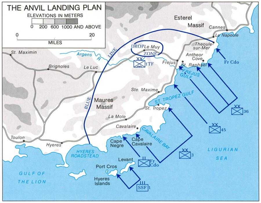
The planned beachhead was to have a radius of roughly twenty miles from its center at Cape St. Tropez. On the southwest, the arc, or “blue line,” began at the shores of the Hyeres Roadstead at Cape de Leoube, about eighteen miles southwest of Cape Cavalaire, curved in-land to a depth of about twenty miles, and curved back to the beach at La Napoule, eight miles north of Antheor Cove (See Map 5). The straight-line distance at the base of the arc, the beachline, was roughly forty-five miles. Within the beachhead area lay three-quarters of the Massif des Maures, the entire Esterel, and the northeastern part of the Toulon–St. Raphael corridor. The blue line passed close to Le Luc, near the middle of the corridor, and included important sections of the main highways and railroads leading west and southwest toward Toulon, Marseille, and the Rhone River, as well as northeast toward Cannes and Nice.
Army planners believed that this projected beachhead had sufficient depth to protect the landing sites
from long-range German artillery; provided space for support airfields and adequately dispersed supply dumps; and gave the initial Allied ground combat units—the U.S. VI Corps and the leading echelons of the First French Army—enough area in which to maneuver. Seizing the terrain within the blue line would also provide the Seventh Army with high-ground anchors for its flanks as well as dominating heights along which Allied troops could prepare defenses against German counterattack. Ensconced along this high ground, Seventh Army forces could deny German access to the beachhead, while simultaneously preparing to break out in the direction of Toulon and Marseille.
After securing the landing beaches, the VI Corps had three primary missions: occupy all the terrain within the blue line as quickly as possible; protect the Seventh Army’s right flank; and prepare to launch attacks to the west and northwest on order. Specific D-day tasks included capturing Le Muy, some ten miles inland along the Argens River valley west of St. Raphael; making contact with the 1st Airborne Task Force in the vicinity of Le Muy; and moving out from both flanks of the beachhead to link up with French commandos, who were to land beyond the limits of the main assault beaches.
The 1st Airborne Task Force and French commando assaults, as well as landings by the 1st Special Service Force, were to precede the VI Corps landings. Seventh Army plans had originally called for scattered paratroop drops; but, on the advice of Generals Frederick and Williams, respectively commanding the airborne “division” and the troop carrier aircraft, Patch agreed to concentrate the drops in the vicinity of Le Muy, where the paratroopers were to begin their jumps well before first light on D-day. The 1st Airborne Task Force’s main mission was to prevent German movements into the beach area from the direction of Le Muy and Le Luc through the Argens River corridor. The paratroopers were also to clear the Le Muy area, securing it for subsequent glider landings.
Colonel Walker’s 1st Special Service Force was to land about midnight of 14–15 August on the two easternmost Hyeres Islands, Port Cros and Levant. Lying just south of Cape Cavalaire, the two islands were believed to shelter numerous German artillery batteries that controlled the approaches to VI Corps’ westernmost beaches. Their early capture was imperative.
Shortly after the 1st Special Service Force started ashore, the French African Commando Group was to make its assault on the mainland at Cape Negre, just north of the two islands and five miles west of Cape Cavalaire. After destroying any German coastal defenses in the area, the commandos were to establish roadblocks along the coastal highway, secure high ground up to two miles inland from the cape, and forestall any German efforts to move against VI Corps’ beaches from the west. Meanwhile, at the opposite end of the beachline, the small French Naval Assault Group was to land at Trayas Point, about four miles northeast of Antheor Cove, and block the coastal highway on VI Corps’ right, or northeastern, flank.
H-hour for the main landings over
the Cape Cavalaire–Antheor Cove beaches was set for 0800, considerably later than had been the case during earlier amphibious operations in the Mediterranean. The hour selected represented a compromise between two conflicting demands. On the one hand, the preassault air and naval forces required sufficient daylight to permit observed and accurate bombardment of German beach defenses. But the landings also had to begin early enough to move sufficient troops and supplies ashore, establish a firm beachhead, and penetrate into the high ground behind the beaches to prevent a German counterattack.
The landing plan originally agreed to by the Seventh Army and the Western Naval Task Force called for putting the 36th Infantry Division ashore on the left, the 45th in the center, and the 3rd on the right.3 This plan also allocated all of the larger amphibious assault vessels, such as LSTs, LCTs, and LCIs, to the 3rd and 36th Divisions, leaving the 45th Division to be loaded onto troop transports and landed by small craft and amphibious trucks (DUKWs) over a number of small beaches along the northern and southern shores of the St. Tropez gulf.
After VI Corps entered into the planning process, Patch’s staff made several changes in the plan at the insistence of Truscott, the corps commander. Truscott wanted to land his most experienced division, the 3rd, on the left so that he could quickly concentrate it to form an offensive spearhead for a drive on Toulon. His least experienced unit, the 36th, he felt, should be put ashore on his right, giving the division a primarily defensive mission. Furthermore, he requested that his central division, now the 45th, be landed and concentrated in the vicinity of Ste. Maxime. Truscott also asked that the amphibious resources be more evenly distributed, allowing two regimental combat teams from each division to be landed by small amphibious craft and LSTs. Finally, he wanted the blue line pulled in slightly on the west, fearing that the original beachhead area would force him to overextend to the west and thus prevent him from massing for an early drive on Toulon. Both Patch and Admiral Hewitt readily agreed to these modifications.
Truscott was less successful in persuading Hewitt to undertake operations against German underwater obstacles believed to be in the landing areas. The corps commander requested that naval forces conduct a thorough reconnaissance of all beaches before the assault, and destroy whatever obstacles might be discovered. Hewitt disagreed, judging that the great difficulties created by underwater obstacles during the OVERLORD assault would not be a factor in ANVIL. The scant tidal range along the Cape Cavalaire–Antheor Cove coast would not provide the Germans with the opportunity to construct such formidable obstacles as had the great tidal variations along the Normandy beachheads. Hewitt also felt that a detailed preassault reconnaissance would only risk revealing the projected landing sites. Thus he
turned down the request.
Studying all available information, VI Corps, Seventh Army, and Western Naval Task Force settled on nine separate assault beaches for VI Corps. The nature of the terrain in the assault area, combined with known or suspected German defensive installations and potential German routes of counterattack, resulted in an undesirable but necessary separation of the assault beaches. Some, for example, were as much as eight miles from their nearest neighbor. Varying from 80 to 4,500 yards in width, and from 10 to 50 yards in depth, each beach presented individual problems. Nevertheless, Allied planners believed that they had no choice but to accept the risks such separations presented.
On the left, the 3rd Infantry Division was to land across beaches in the Cavalaire Bay–St. Tropez region. The division’s first two regiments were to be put ashore in the Cavalaire Bay and St. Tropez areas, with the third regiment following in the Cavalaire Bay sector. Thereafter the division was to clear the St. Tropez peninsula, which separated Cavalaire Bay from the St. Tropez gulf; seize St. Tropez and the town of Cavalaire; secure the Cavalaire–St. Tropez road; and, upon corps orders, strike west toward the blue line and Toulon.
The 45th Division in the center was also to send two regiments ashore in the assault, landing them abreast about two miles northeast of Ste. Maxime. Its third regiment was to follow the others ashore, but was to be committed only with Truscott’s permission. On the morning of D-day the 45th was to capture Ste. Maxime and nearby high ground, move north and northeast to clear the shoreline and hills for two miles inland, and drive to the Argens River, about eight miles north of Ste. Maxime.
On the right, the 36th Division was to land only one regiment at H-hour, putting it ashore on a broad beachline about four miles east of St. Raphael, with one infantry battalion to make its assault at Antheor Cove, three miles farther away. A second regiment was to follow the first ashore over the beaches east of St. Raphael, while plans called for the third to land at 1400 farther west between the mouth of the Argens River and St. Raphael. Planners estimated that elements of the 45th Division would be in position south of the Argens to support the 36th Division’s last regiment in the Frejus gulf region. If for some reason it proved impossible to make the afternoon assault north of the Argens, the 36th Division’s third regiment would also go ashore at the main landing beaches to the east.
The 36th Division’s most pressing mission was to protect Seventh Army’s right flank, a task that entailed a rapid drive to the northern end of the blue line at La Napoule. The division’s other missions included seizing St. Raphael; capturing Frejus, two miles west of St. Raphael; advancing inland along the Argens valley to join elements of the 1st Airborne Task Force; and, if the airborne units were unable to do so, clearing Le Muy and its environs.
Combat Command Sudre (CC Sudre) of the French 1st Armored Division was to land on D-day over 36th Division beaches, assemble in the Frejus area, and prepare to strike
westward through the Argens valley. Initially, the French armor was to serve as the VI Corps’ reserve and exploitation force. But before the end of July, Truscott had become dissatisfied with arrangements for his control over CC Sudre, the only homogeneous armored unit under his command.4 The First French Army expected the return of this brigade-sized armored force as soon as significant French forces were assembled ashore, probably by D plus 3. De Lattre wanted Sudre’s armor to protect the French right, or northern, flank during his subsequent attacks against Toulon and Marseille and to provide armored strength against any German panzer units that might counterattack the French. Since Seventh Army could not promise that VI Corps would retain CC Sudre past D plus 3,5 Truscott decided on 1 August to organize a light mechanized combat command from American forces assigned to the VI Corps. The unit, later designated Task Force Butler (TF Butler),6 included one cavalry squadron, two tank companies, one battalion of motorized infantry, and supporting artillery, tank destroyers, and other ancillary forces. Truscott placed the provisional unit under Brig. Gen. Frederick B. Butler, the VI Corps deputy commander, and initially viewed it as a substitute for CC Sudre, assigning it the relatively limited mission of assembling in the vicinity of Le Muy and preparing to attack either west or northwest on corps orders. In addition, its late organization precluded its loading as a separate entity, and the task force was not scheduled to be assembled at the beach area until D plus 2.
If all went according to plan on D-day, the vanguard units of First French Army were to start landing over U.S. 3rd Infantry Division beaches on the VI Corps’ left flank on D plus 1. The early arrivals were to include the French 1st Infantry Division, the 3rd Algerian Infantry Division (less one regiment), and the French 1st Armored Division (less CC Sudre and another combat command). Plans also called for the 9th Colonial Infantry Division, with two Moroccan Tabor Regiments (light infantry) attached, to arrive by D plus 9, but the rest of the French II Corps, including the last elements of the 1st Armored Division, were not to reach southern France until D plus 25.
After assembling on shore, the leading French units, strengthened by CC Sudre, were to pass through the VI Corps left wing and strike for Toulon, which Seventh Army hoped would fall by D plus 20, 4 September. Following the seizure of Toulon, the French were to move against Marseille, simultaneously preparing to strike northwest toward the Rhone at Avignon. Marseille, Allied planners estimated, would probably not be in French hands until D plus 40 to 45, or about 25 September.
A final aspect of the ANVIL ground plan concerned the French Forces of the Interior (FFI). Seventh Army,
acting in concert with General Cochet, the FFI director for southern France, and with Special Projects Operations Group at AFHQ assigned the FFI a series of missions designed to hamper German movement into the ANVIL assault area and to assist Allied advances throughout that area. First, FFI forces were to destroy bridges, cut railroad lines, and block highways. Next, they were to try to create major diversions inland in order to disperse or pin down German forces that might otherwise mass for counterattacks against the beachhead. Third, the guerrillas were to cut telephone and telegraphic communications systems throughout southern France. Fourth, the FFI was to attack German fuel and ammunition dumps, sabotage German airfields, and engage isolated German garrisons and small units. Finally, they were to prepare to conduct tactical combat operations on the flanks of whatever routes the Allied assault divisions might use in breaking out of the beachhead.
Air and Naval Support Plans
Although Allied planners were confident that German forces in southern France would be unable to prevent a successful lodgment along the Cape Cavalaire–Antheor Cove coastline, the planners also knew that the cost of the landing, as well as the speed of VI Corps’ advance inland to the blue line, would depend largely upon the efficacy of the preassault air and naval bombardment.7 The success of the French drives against Toulon and Marseille would likewise depend heavily on air and naval support. The most dangerous threat, however, was the ability of the German defenders to assemble enough forces for an effective counterattack on the beachhead. The ultimate success of ANVIL would thus hinge a great deal on the efforts of the air arm, with assistance from the FFI, to isolate the landing area.
Air attacks at least indirectly related to ANVIL had been under way for many months before 15 August as part of the Mediterranean Allied Air Forces’ general program of operations. Moreover, MAAF operations in support of OVERLORD, although designed mainly to slow German redeployments to northern France, also contributed to ANVIL. However, from 2 July to 5 August MAAF was able to devote relatively little effort to southern France because of the demands of ground operations in Italy as well as the priority given to strikes against German oil and rail facilities in eastern and southeastern Europe. During July, air attacks over southern France were directed primarily against German naval installations at Toulon, various rail centers, and bridges over the Rhone and Var rivers (the latter between Cannes and Nice). At the same time, air operations in support of the FFI were stepped up.
The first phase of an air campaign more directly associated with ANVIL began on 5 August. From 5 to 9 August, MAAF’s primary missions were to neutralize Luftwaffe units in
southern France and northwestern Italy, interdict German communications between Sete and Genoa, and attack German submarine bases. From 10 August to approximately 0350 on the 15th, MAAF was to pay special attention to German coastal defenses, radar stations, troop emplacements, and communications. This phase was to culminate on the 14th with especially heavy attacks against overland communications and selected bridges. The final phase of the preassault aerial bombardment was to begin at first light (approximately 0550) on D-day and last until 0730. During this last effort air attacks were to be concentrated against coastal guns, beach defenses, underwater obstacles, and troop installations.
MAAF had adopted the program of bombing German coastal defenses in the Cape Cavalaire–Antheor Cove area before D-day with some reluctance. Air planners felt that, to ensure tactical surprise at the assault beaches, the coastal bombardments should extend from the Spanish border all the way around to the Italian coast southeast of Genoa. General Eaker, commanding MAAF, believed that, in conjunction with the naval bombardment on D-day, air attacks could destroy all significant shore defenses in the assault area in less than two days, that is, D minus 1 and the morning of D-day.
Both Patch and Truscott, concerned that surprise not be lost, were inclined to agree with Eaker’s estimate. But Navy planners were not so optimistic. Admirals Cunningham and Hewitt, for example, felt that an air bombardment limited to D minus 1 and D-day, even in conjunction with strong naval shelling, could not effectively neutralize German coastal defenses in the area. Instead, the Navy held that a more complete destruction of German coast defenses, including radar installations, would at least partially compensate for the loss of tactical surprise. They also pointed out that concentrated air attacks on D minus 1 and D-day would probably alert the Germans to the location of the assault beaches in any case. Moreover, a concentration of air effort in the Cape Cavalaire–Antheor Cove area on D minus 1 might start forest and supply dump fires, the smoke from which could obscure targets ashore for the crucial air and naval bombardments of D-day morning.
Taking the Navy concerns into consideration, Seventh Army and MAAF agreed to stretch out the planned air campaign, with one proviso. To avoid the risk of disclosing to the Germans the selected assault beaches early in the game, Eaker insisted that his command would divide its efforts more or less equally among four potential landing areas between 5 and 13 August: Sete and vicinity, the Toulon–Marseille region, the Cape Cavalaire–Antheor Cove coastline, and the Genoa area.
The D-day air and naval attacks presented some equally complex problems for the planners. To be effective, the bombardments would have to start just after first light, but air strikes would have to cease early enough to allow smoke and dust to settle, thus providing better visibility for the final naval bombardment. In addition, the time allocated to naval gunfire could not be too long, for the naval forces in the Mediterranean
possessed but limited supplies of ammunition for their larger guns. Bombardment vessels would have to conserve some ammunition to support operations ashore after the assault.
Planners ultimately decided that the last concentrated air strikes should start at 0610 and end at 0730, when the naval gunfire support ships were to begin a final, drenching shelling of the assault beaches. From 0650 to 0730 naval bombardment was to be limited to carefully selected targets in the assault area (and mainly to its flanks), and this was to be lifted when MAAF bombers were striking the beaches. Such an arrangement demanded especially tight coordination of air and naval operations. From 0610 to 0730 fighters and bombers were to give first priority to German artillery positions, and second priority to German installations that might block the advance inland. The air strikes were to give special attention to any German weapons that could not be reached by the relatively flat trajectory of naval gunfire. The half hour (0730–0800) left for the final naval bombardment was a considerably shorter period than normally needed for most amphibious assaults, especially in the Pacific, but the circumstances of the ANVIL assault left little choice. In effect, the concentrated air bombardment early on D-day would have to substitute for more extended naval gunfire.
In addition to its responsibilities for landing and supporting the assault forces, Western Naval Task Force also had the mission of conducting a series of diversionary operations. Task Group 80.4, the Special Operations Group, was to make two such efforts. Starting from Corsica on D minus 1, on a course headed toward Genoa, one section of the group was to swing northwest about midnight to create diversions in the Cannes–Nice area. MAAF planes, dropping various types of artificial targets, were to help the naval contingent to simulate a much larger force. A westerly naval unit, simulating a convoy twelve miles long and eight miles wide, was to operate meanwhile along the coast between Toulon and Marseille. MAAF was to add to the confusion by dropping dummy parachutists in the same region.
The final arrangements for air and naval bombardment, the selection of H-hour, and the type of landings thus represented marked departures from previous amphibious operations in the Mediterranean. ANVIL’s H-hour was considerably later than was usual in the Mediterranean, where previous landings had taken place under cover of darkness. But earlier assaults in the Mediterranean had been directed against unfortified and virtually undefended coasts. Accordingly, for the first time in Mediterranean experience, planners had to arrange heavy, concentrated air and naval bombardment before H-hour on D-day. Finally, the air bombardment plan for D-day demanded that heavy bombers execute mass takeoffs during the hours of darkness, another first in the Mediterranean theater, in order to reach their objectives on schedule.
Beyond D-day
Until early August, the Seventh Army had no firm plans for the campaign
following the seizure of the beachhead and the capture of Toulon and Marseille. The ANVIL directive from AFHQ directing Patch’s forces to exploit northward up the Rhone toward Lyon was extremely vague. Estimated German resistance, together with the logistical problems involved in supporting large forces in southern France until the port of Toulon at least became operational, made it appear that Seventh Army and First French Army forces would not be ready to strike north along the axis of the Rhone much before 15 October. In early June, well before OVERLORD began, Mediterranean planners believed that it might even be mid-November before Patch and de Lattre had control over the Rhone valley from the Mediterranean north to Lyon. More detailed plans for future operations therefore were not an immediate concern.
But as June and July passed and Allied intelligence officers tallied the German withdrawals from southern France, prospects for more rapid progress grew accordingly. At AFHQ Wilson foresaw a possibility that a weakened Army Group G, failing to contain Seventh Army’s beachhead or to hold Toulon, would concentrate on the defense of Marseille and the approaches to the Rhone. In such a case, Army Group G might leave the area east of Marseille and the Rhone River valley nearly undefended. Available information indicated that the Germans had only one understrength division scattered about this eastern flank area, a region where, the Allies knew, the FFI was strong and active.
With this information, Wilson, on 11 August, proposed two new courses of action.8 First, he suggested that the Seventh Army could strike northwest directly from the beachhead to the Rhone north of Avignon, leaving only minimum forces in the Marseille area to secure the left and to contain German units in the Rhone delta. A second possibility was to strike generally north from the beachhead through the Provence Alps toward the Grenoble area, over one hundred miles north of Toulon.
Wilson apparently regarded the proposed thrust to Grenoble primarily as a means of protecting the Seventh Army’s right flank and stimulating FFI activity east of the Rhone. But Patch and particularly Truscott saw in Wilson’s suggestions an opportunity to exploit whatever weaknesses might be found in German defenses between the Rhone and the Italian and Swiss frontiers. For such purposes, Truscott already had an exploitation force available, TF Butler. Although he had originally planned to employ it only in a limited role, its missions could be easily expanded if the situation warranted.
The VI Corps commander subsequently drew up tentative plans to rush TF Butler to the Durance River as soon as the force could assemble ashore. His plans allowed for two possible thrusts: one to cross the Durance River and strike west for the Rhone near Avignon; or, alternatively, another to drive on north toward Grenoble. The latter maneuver, Truscott thought, could develop either
into a swing west to cut the Rhone valley between Avignon and Lyon, or into a drive through Grenoble to Lyon. With quick success by TF Butler, VI Corps would be in a position to outflank German defenses along the lower Rhone and to block an Army Group G withdrawal up the Rhone valley. But the feasibility of such projects depended on the speed with which the Seventh Army reached the blue line, the strength of opposition in the beachhead area, and Army Group G’s reaction to the ANVIL assault.
Allied Intelligence
Because of the prodigious Allied information collection effort, including the highly secret ULTRA intercept program, the Seventh Army had a reasonably accurate picture both of the organization and strength of the German forces in the ANVIL assault area and of German deployments all along the Mediterranean coasts of France and Italy.9 The main problem facing intelligence personnel was to keep up to date with the constant movement of German units in and out of southern France since OVERLORD began. Due to the frequency of these movements, the Seventh Army did not have completely accurate information on the specific location of German corps and division command posts in the assault area; and information on units at and near the assault beaches, while generally correct, was sometimes erroneous in detail. Despite these shortcomings, however, the information available was fairly complete and accurate.
Seventh Army intelligence estimates placed German strength in the coastal sector from the Rhone delta east to the Italian border at approximately 115,000 troops, a figure that was probably too high by at least 15,000. On paper, the Germans appeared to have sufficient force to put up a strong defense, but the Seventh Army knew that many German units were not up to strength and that many others were second-rate formations. German coastal defenses were known to be fairly strong in some locations but quite weak in others, and available information indicated that the defenses lacked depth. Once Allied forces pushed through the narrow belt of German coastal defenses, Seventh Army planners felt that they would encounter few other prepared defensive installations except at Toulon and Marseille. Seventh Army intelligence estimated the German Toulon garrison at 10,000 troops and the Marseille defenders at 15,000 (actually, the Germans had 13,000 men at Toulon and 18,000 at Marseille). The garrisons were known to include not only German Army infantry and artillery, but also engineer, antiaircraft, and fortress troops, communications and supply units, and various naval personnel.
The Allies also knew that there would be little danger from German air and naval forces. ANVIL planners put Luftwaffe strength in southern
France around 250 aircraft, of which less than two-thirds would be operational on 15 August. Considering the demands of the current battles in northern France and Italy, they expected that the Luftwaffe would not be able to send any significant reinforcements to southern France and that its operations during the landings would be limited to scattered torpedo-bomber attacks and some night mine-laying sorties, with fighters probably used for air defense only.
Admiral Hewitt’s staff considered German naval strength in southern France insignificant. With approximately one destroyer, seven corvettes, five torpedo boats, five or six submarines, and miscellaneous small auxiliaries—and it was doubtful that the destroyer or the submarines were operational--they deemed the Germans incapable of significant offensive action at sea.
The Allies had no expectation of achieving strategic surprise. Believing that German aerial reconnaissance would have discovered the obvious preparations for a major amphibious assault, they correctly estimated that the Germans would expect the attack to come along the French Riviera as opposed to the Atlantic or Ligurian coasts. On the other hand, Seventh Army hoped to achieve some degree of operational and tactical surprise concerning the exact time and place of the landings. But keeping the 15 August target date a secret was difficult. The need to coordinate FFI operations with the assault considerably increased the potential for compromising security, while the final air bombardment would also give away the time and place of the landings. But with the many deception efforts undertaken, the Allied planners felt reasonably confident that the Germans would be unsure of the precise date and location of ANVIL until 14 August, and even then the defenders would not be completely certain until the Allied landing craft were actually sighted heading toward the shore. In addition, Seventh Army planners believed that Army Group G would not be able to oppose the initial landings effectively nor those of the French follow-up divisions.
The main problem facing Allied intelligence officers was ascertaining the German response once the Seventh Army was ashore. They estimated that neither OB West nor OB Southwest would be able to reinforce Army Group G after the ANVIL assault. Nevertheless, they believed that Army Group G’s most probable course of action would be to try to contain the Allied beachhead by attempting to hold the Massif des Maures. But given the current disposition of German forces, Seventh Army also believed that the defenders would be unable to redeploy enough strength into the Maures to secure the range before French and American forces could move inland and occupy the terrain. Faced with strong Allied forces in the hills above the beachline, the Germans would probably fall back on the defenses of Toulon and Marseille. From Toulon the Germans could pose a serious threat to Allied lines of communication, inhibiting all westward advances toward the Rhone valley. Moreover, the Germans undoubtedly recognized the logistical importance of the port cities to the Allies. The longer the Germans held on to Toulon and Marseille,
the more difficult it would be for the Seventh Army to project its combat power far from the landing beaches.
Should the Germans fail to hold the two major ports for an extended period, Seventh Army planners estimated that Army Group G would withdraw up the Rhone valley, making temporary stands at successive delaying positions. However, they considered it unlikely that the Germans would start withdrawing up the Rhone valley until Army Group G had begun to exhaust its defensive potential in the coastal sector. This depletion, Seventh Army estimated, would probably not occur until the fall of Toulon, expected about 5 September.
The Role of ULTRA
During these discussions the Seventh Army intelligence staff undoubtedly benefited greatly from the information derived from ULTRA, code name of the now Anglo-American operation for intercepting, decoding, and disseminating the radio communications of the German high command. Raw ULTRA information would in fact be available to the principal American commanders in southern France—Generals Devers, Patch, and Truscott10—and to their main staff officers throughout the entire campaign. When correlated with other intelligence, this data usually gave them a fairly good idea of the opposing order of battle, that is, the strength and location of the major German units opposing them. This picture, in turn, enabled them to have a better understanding of German military capabilities and intentions. In a few cases, ULTRA intercepts even provided Allied commanders with critical German orders almost before the designated recipients had received them in the field.
ULTRA, however, also had its drawbacks and limitations. First, raw intelligence was often of limited value until it could be correlated with other information sources—prisoner of war reports, air reconnaissance, captured documents, and observations of tactical ground units on the battlefield. Second, many key military decisions were made by the Germans during command conferences, and detailed plans were normally hand-carried by staff liaison officers, with little of this information ever being transmitted directly through wireless communications. As a result, ULTRA was often mute regarding specific German intentions. In addition, both OKW and OB West, and even Hitler, sometimes gave field commanders a wide degree of latitude in carrying out their missions (or sometimes orders were ignored), further reducing the value of ULTRA in revealing specific German operational and tactical intentions. Finally, the time between the interception of a radio transmission and its arrival in a decoded, translated format at the field commands was normally about twelve to twenty-four hours, or longer depending on the significance of the message. For this reason ULTRA information was less useful during fluid combat situations; moreover, it was often only of limited
value at division and lower echelons where highly perishable tactical intelligence often arrived too late to be significant. Thus, although ULTRA was of undisputed value in outlining the general German military situation on the battlefield, it in no way obviated the need for Allied intelligence staffs to rely on a wide variety of information sources concerning their opponents and to continue their traditional but time-consuming analysis efforts to turn that information into intelligence useful to the operational and tactical commanders on the battlefield.11
Finally, to put ULTRA in perspective, the contribution of the Office of Strategic Services (OSS) intelligence networks established in southern France under Henry Hyde should also be noted. Based in French North Africa, Hyde’s organizing effort began approximately one year before the invasion; the final OSS network included about 2,500 intelligence agents throughout the area held by Army Group G. These agents usually communicated information on German military forces to the central OSS headquarters in North Africa through an extensive and elaborate secret radio system, and smuggled maps, overlays, sketches, drawings, photographs, and similar material through Spain. Hyde himself worked closely with the Seventh Army G-2 (assistant chief of staff for intelligence), Col. William W. Quinn, and Quinn even made special arrangements so that he could receive OSS reports at sea during the voyage to the assault area. From these agent reports, the Seventh Army was able to piece together an even more detailed picture of German dispositions and strength. In fact, on 13 August, just before the actual landings, a French OSS agent, bicycling from Cannes to Hyeres, made a final survey of the landing
areas; the report was quickly cabled to Quinn aboard the Seventh Army’s command ship, making any last-minute surprises on the assault beaches extremely unlikely. Later, at the request of Patch and Quinn, the OSS assigned intelligence teams (from the Strategic Services Section, or SSS) to each of the American combat divisions, and the organization continued to provide order-of-battle information to the Seventh Army staffs throughout the ensuing campaign.12 ULTRA was thus only one of many Allied intelligence sources used by the Seventh Army, and only in extremely rare instances would it provide information that could not have been obtained elsewhere.
Final Assault Preparations
Because the Seventh Army did not gain control over most ANVIL ground assault units until late June—and some French units not until late July—the time available for final training, rehearsals, loading, and logistical preparations was limited.13 On the other hand, many of the assault units already possessed ample amphibious experience, and most of the remainder had acquired extensive combat experience in Italy, all of which eased the compressed tactical planning, training, and loading requirements. ANVIL training emphasized amphibious loading and unloading procedures including small craft embarkation and debarkation, ship and vehicle loading, the operations of joint Army-Navy fire control parties, the tactical command and control problems peculiar to assault landings, and other related matters. Special attention was also given to the destruction of underwater and beach obstacles. In addition, the estimated strength of German beach defenses demanded that some sort of armored support move ashore with the assault waves. Lacking “amtracks”—the armored, tracked landing vehicles that played a critical role in most Pacific amphibious assaults during World War II—the Seventh Army had to train selected elements of medium tank battalions in the operation of the floatable but less stable duplex-drive (DD) tanks available in the European theater.14 The assault plan called for each
45th Infantry Division troops load up at Bagnoli, Italy, August 1944.
division to set eight DDs ashore at the time of or immediately after the first landing waves.
Much of the training for the assault units took place at Seventh Army’s Invasion Training Center near Salerno, Italy, although the 3rd Division ran its own school at Pozzouli. Participating in the training and directing most of the final phases were elements of Western Naval Task Force. The three VI Corps divisions undertook final rehearsals along the Italian coast between 31 July and 6 August. Although the training of the tactical ground units was fairly complete and realistic, the lack of time made it impossible to undertake more than token unloadings of vehicles and cargo, while some landing ships and other vessels reached the Mediterranean so late that they could not participate in the final rehearsals. In addition, although MAAF aircraft undertook limited air support operations, training staffs were unable to incorporate naval gunfire into the rehearsals, and the nine days remaining between the completion of the rehearsals and the assault were not enough for extended critiques and remedial instruction. However, the previous experience of most VI Corps units in amphibious operations had to substitute for more extended training.
The 1st Special Service Force started
ANVIL convoy enroute to Southern France, August 1944.
its training in early July south of Salerno, emphasizing the use of rubber assault boats, scaling of cliffs, and attacks on fixed defenses. The force undertook final rehearsals on islands off the Italian coast during the night of 7–8 August—rehearsals that, Colonel Walker later reported, were far more rugged than the actual assaults on the Hyeres Islands. The French commandos received similar training elsewhere.
Many paratroop elements of the 1st Airborne Task Force had received refresher training on Sicily during May, and thus preassault preparations focused on unit training, with special attention to ground tactical operations. A shortage of parachutes in the theater precluded final rehearsal jumps, but all glider units undertook at least one flight and landing. The entire task force limited its final rehearsal to a ground exercise near Rome, and completed its preparations for ANVIL by 12 August.
Final loading and staging for all seaborne elements began on 8 August. Most VI Corps assault units loaded at Naples and Salerno, but CC Sudre of the French 1st Armored Division came from Oran in North Africa. The French 1st Infantry Division and the 3rd Algerian Infantry Division staged at Brindisi and Taranto, ports on Italy’s heel, as did a few smaller French units. The 9th Colonial Infantry Division and a Moroccan Tabor regiment boarded ship from Corsica, and most MAAF units staged
on Corsica. The rest of First French Army, scheduled to arrive much later, was to be shipped from Italy and North Africa.
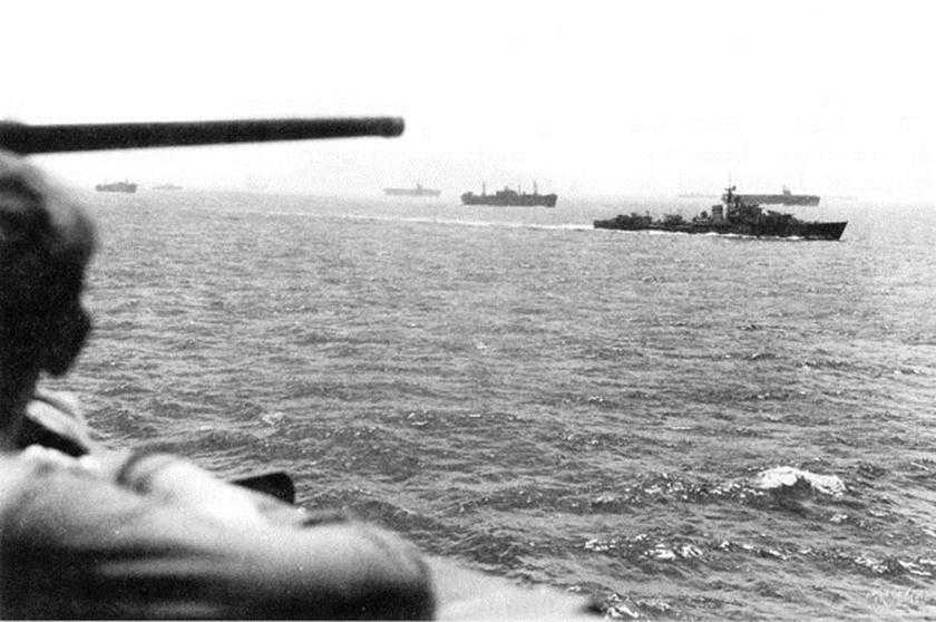
The loading from scattered ports, the need to keep shipping within range of land-based air cover, the varying speeds of the vessels of the assault convoys, naval diversionary operations, and the pre-H-hour assaults by the 1st Special Service Force and French commandos combined to force Western Naval Task Force to set up a complex convoy schedule. Each separate group of ships and landing craft had to move along carefully prescribed routes to make the rendezvous with other groups at selected times and points. All VI Corps assault units aboard LCTs and LCIs, together with the 1st Special Service Force on American APDs and British LSIs, also had to complete their final staging on Corsica.
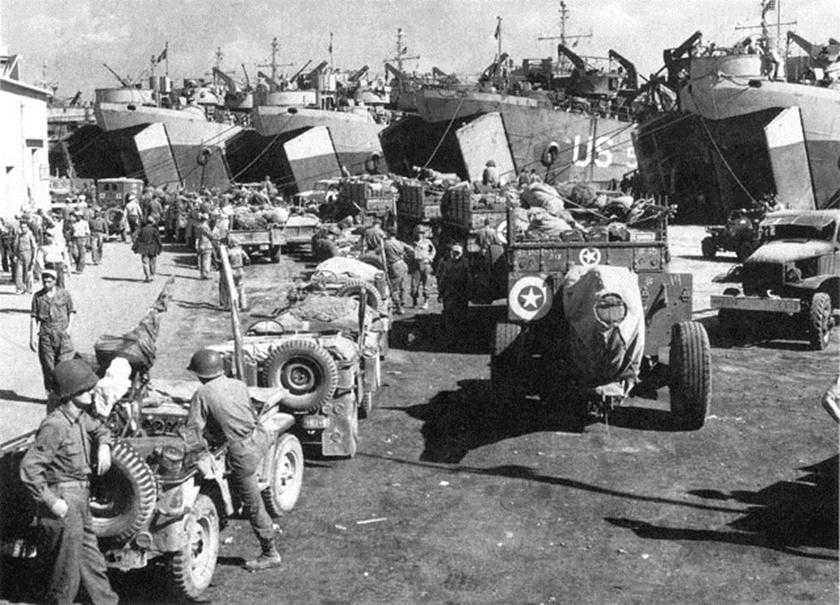
The final D-day convoys comprised approximately 885 ships and landing craft sailing under their own power. On the decks of this armada were loaded nearly 1,375 smaller landing craft. Exclusive of naval crews, the convoys carried roughly 151,000 troops and some 21,400 trucks, tanks, tank destroyers, prime-movers, bulldozers, tractors, and other vehicles. Included in these totals were about 40,850 men and 2,610 vehicles of the First French Army that were to start unloading on D plus 1. After a few minor problems in the final loading and departures, Admiral Hewitt was able to report that “all convoys sailed as planned without incident and rendezvous were effected as scheduled.”15