Chapter 2: The Opening Moves
Area of Conflict1
Prior to the outbreak of war, the strategic area centered on Rabaul was a slow-paced frontier of Western civilization. Economic development of the Bismarck Archipelago, the Solomon Islands, and Eastern New Guinea was pretty well limited to the cultivation of coconut palms for copra. The coconut plantations, together with a scattering of trading posts, missions, and government stations, housed the relative handful of nonnative inhabitants. The islands had little in the way of climate or terrain to attract tourists or anyone else without a surpassing good reason for visiting them. For the most part the area remained as it had been when the first European explorers visited it in the middle of the sixteenth century.
More than 300 years passed before a Western nation thought it worthwhile to lay claim to any of the islands. Then Germany, as part of her belated attempt to build a colonial empire, followed her traders and missionaries into Northeast New Guinea, the Bismarcks, and the Northern Solomons, proclaiming them the protectorate of Kaiser-Wilhelmsland in 1884. Britain countered by establishing her own protectorate over the Southern Solomons and by annexing the rest of Eastern New Guinea. As the Territory of Papua, with a capital at Port Moresby, this latter area was turned over to Australia in 1905. At the outbreak of World War I, the Australians occupied Kaiser-Wilhelmsland and kept it, under a League of Nations mandate following the peace, as the Territory of New Guinea. The mandate capital was established at Rabaul,2 and the territory divided into government districts of Northeast New Guinea, New Britain, New Ireland, Manus (the Admiralty and Northwest Islands), and Kieta (Buka and Bougainville). South of Bougainville, the Solomons, including the Santa Cruz Islands, formed the British Solomon Islands Protectorate, administered by a resident commissioner at Tulagi.
Each island in the Rabaul strategic sphere, with the exception of a few outlying atolls, has a basic similarity of appearance which holds true regardless of size. High hills and mountains crowd the interior, sending out precipitous spurs and ridges to the coasts. A matted jungle canopy of giant trees covers all but the highest peaks, and the sun touches the ground only along the banks of the numerous streams
that slice the slopes. Where fire or water forces a temporary clearing, the vine and bush barrier of second growth springs up to add to the difficulties of transit. Along the shores most of the low-lying ground is choked with rank second growth, and vast stretches of fetid mangrove swamp mark the mouths of streams and rivers. Easily accessible and well-drained land is at a premium and on most such sites coconut plantations had been established. Years are required to grow the trees and constant attention is needed to prevent the encroachment of jungle. These plantations, together with the few significant reaches of grassland scattered throughout the larger islands, were the potential airfields that figured so prominently in Southwest Pacific planning.
Along with tropical forest and rugged hills, the area shares a common climate—hot, humid, and unhealthy. There is a rainy season around December when the northwest monsoon blows, but the “dry months” of the southeast trade winds, April through October, are wringing wet by temperate zone standards. Although the amount of precipitation varies considerably according to locale, an average rainfall of more than 200 inches in the uplands and 100-150 inches along the coasts is not unusual. The islands lie in the only latitudes in the world where evaporation is greater over land than water.3 The temperature of the moisture-saturated air stays in a steady range of 75-90 degrees the year around. Constant high heat and humidity sap a man’s strength and make him prey to a wide variety of tropical diseases.
Strange though it may seem, this uninviting area has well over a million inhabitants. The majority are Melanesians, the dominant race in the islands northeast of Australia. Primitive in habit and appearance, these people have dark brown, almost black, skins, small but solidly-built bodies, and frizzled, upstanding mops of hair. The natives of Papua belong to a related but separate race, shorter, darker, and more Negroid in aspect. In the atolls around the periphery of the area there are a few thousand Polynesians, tall, fair, and fine-featured members of the race that occupies the Central Pacific islands. Mixed marriages among these peoples are not uncommon; the Melanesians themselves are thought to be the product of a merging of Papuan and Polynesian strains.
Tribalism is the way of life in the islands; there is no native national spirit or tradition. The frankly paternalistic British and Australian administrations respect the tribal organization and govern through the local chiefs. Almost all the natives live in small villages, their outlook limited to what they can see, feel, or hear. Village garden plots, temporarily wrested from the jungle, grow only enough taro, yams, and sweet potatoes for local needs; fruit and fish supplement an otherwise monotonous and starchy diet. Although Christian missionaries have been moderately successful in gaining converts, the basic religion of these simple people is a natural animism. The diversity of dialects is so great that the traders’ jargon of pidgin English is the only universally understood language. By Western standards, the natives live a severely limited life, but this simple existence has the sanction of centuries.
In general, a view of life outside the village is sought and seen only by the laborers who work the coconut plantations and the relatively few natives who serve in the government or police. These men, especially the “police boys,” are capable of great personal loyalty to those who can understand and lead them. The evidence for this statement is easily found in the existence of the spy system that operated behind Japanese lines in the Southwest Pacific.
Years before the enemy invaded the New Guinea Territory and drove south toward Port Moresby and Tulagi, the probability of hostile approach through the island screen had been foreseen by the Australians. In 1919, their Navy began to set up a network of observers along the sparsely settled northeastern shores of the continent. As compact and reliable radios were developed, the observer system spread northward into the islands where strategically located officials and planters were recruited and trained to send coded reports of enemy movements. Many of these veteran islanders, famed as the coastwatchers, remained behind when the Japanese advanced, and from vantage points deep in the midst of enemy-controlled waters, sometimes even from enemy-held islands, fed a steady stream of valuable intelligence into Allied hands. The natives who stayed with the coastwatchers were in many cases their eyes and ears in the enemy camp. Though the opportunity for betrayal was great, it was seldom seized.4
While the success of the coastwatching system was a tribute to human courage and resourcefulness, it was equally an acknowledgment of the complex geographic factors making it possible. Each island and island group that figured in the Allied drive on Rabaul has its own peculiar character, and its detailed description is part of the narrative of the operations that concern it. A general sketch of the whole strategic area is needed, however, to set in mind the relationship of these islands to each other.
On the map, New Guinea, the world’s second largest island, dominates the sea north of Australia. More than 900,000 natives live in the scattered villages of Papua and Northeast New Guinea, an area roughly the size of California. Lofty mountains, some ranging well above 13,000 feet, form a spine for the Papuan Peninsula which juts out into the Coral Sea. In the bulging midsection of the island near the border of Dutch New Guinea, thousands of square miles of soggy ground and tangled swampland spread out along the wandering courses of torpid rivers coming down out of the highlands. The Huon Peninsula, which harbors near its base and southern flank the airfield sites so prominent in the ELKTON planning, thrusts east toward New Britain, less than 50 miles away across Vitiaz (Dampier) Strait. (See Map I, Map Section.)
The tip of western New Britain, Cape Gloucester, has enough low grassland near the coast to allow airfield development. Thus, from the Cape and from the Huon Peninsula, directly opposite on New Guinea, control could be easily maintained over Dampier Strait, the only entry into the Solomon Sea from the northwest. New
Britain, an elongated and crescent-shaped island, 370 miles long and 40-50 miles wide, is heavily forested and has the usual prominent jumble of mountains and hills ridging its interior. Midway along the coasts, Talasea in the north and Gasmata in the south offer way-point airdrome sites for a drive on Rabaul, which “has by all odds the best natural harbor and base for military operations in the entire New Guinea-New Britain-Solomon Islands area.”5
Curving to the northwest from the waters off Rabaul’s Blanche Bay, scimitar-like New Ireland parallels New Guinea’s coastline 300 miles away and closes one side of the Bismarck Sea. The airfields and harbor at Kavieng on the slim island’s northern point made the small colonial town a prime strategic objective. The Bismarck Sea is outlined by a staggered arc of islands which swings north from New Hanover off Kavieng to the Saint Matthias group, then west to the Admiralties and on to the atolls known as the Northwest Islands, which dip south toward New Guinea. The native population of the whole area of the Bismarck Archipelago is approximately 150,000, the largest number by far living on New Britain and New Ireland.
Planes based at Rabaul and at airfields on Buka or Bougainville can effectively close off the passage between New Ireland and Buka, the second major gateway to the Solomon Sea. Politically speaking, these two northern islands are part of the New Guinea Territory; geographically, they are one with the rest of the Solomons. The principal islands of the Solomons constitute a double mountain chain running northwest and southeast for about 700 miles between the Bismarcks and the New Hebrides; the width of this central grouping is 100 miles. Several offshoot islands well away from the main chain—Ontong Java atoll to the northeast, Rennell due south of Guadalcanal, and the Santa Cruz group to the southeast—are also considered part of the Solomons.
In all the islands there are some 165,000 natives living in a total land area equivalent to that of West Virginia. The terrain fits the general pattern of the whole strategic area—jungle and hills extremely difficult to traverse which tend to localize land combat and put a premium on air and sea power. The major islands of the northeast chain, Choiseul, Santa Isabel, and Malaita, have few natural military objectives, and the same lack characterizes San Cristobal, the southernmost of the southwest chain. The other large islands of the Solomons, Guadalcanal, New Georgia, and Bougainville, have sizable harbors and airfield sites sufficient to make them logical stopping points in a deliberate advance on Rabaul. Each of these major island objectives has several smaller islands nearby which also class as potential targets: Tulagi and Florida are coupled with Guadalcanal; Vella Lavella and Kolombangara with New Georgia; and Buka and the Shortland-Treasury Islands with Bougainville.
Typical of the smaller island groups in the Solomons is the Russells, which lie 30-35 miles northwest of Cape Esperance on Guadalcanal. The accident of location rather than any considerable strategic advantage made them Admiral Halsey’s first objective after Guadalcanal was secured.
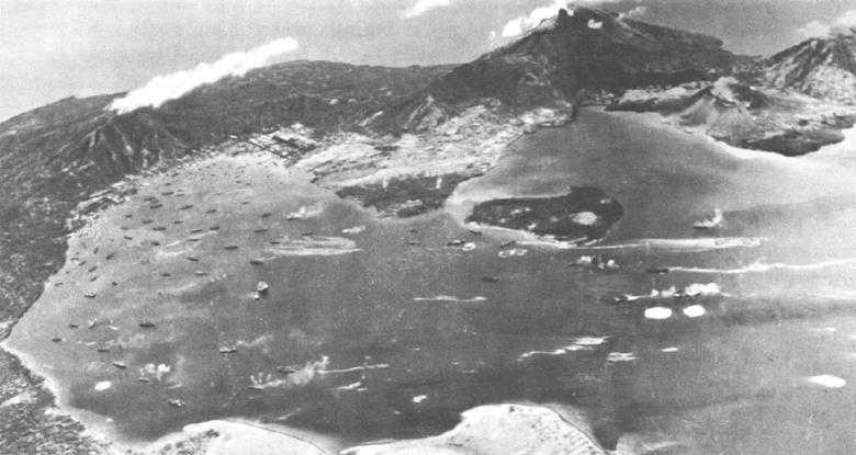
Simpson harbor and Rabaul appear in a composite aerial photograph taken during an Allied air raid prior to the Bismarck Sea battle. (USAF F23272AC)

Marines of the 3rd Raider Battalion land from rubber boats on the beach at Pavuvu to take part in the seizure of the Russells. (USMC 54468)
Occupation of the Russells6
The Russell group consists of two main islands fringed by a scattering of lesser islets. Pavuvu, the larger island, is very irregular in shape and no more than ten miles across at its widest point. The low land along the shoreline of many of its coves and bays is clear of undergrowth and lined with coconut trees, but these plantings only edge the jungle and mark the steep rise towards the hills of the interior. On the north coast, several deep water bays provide sheltered anchorages which will accommodate large ocean-going vessels. Only a narrow channel separates Pavuvu from its smaller neighbor to the east, Banika, which has unusual terrain for the Solomons. Except in its southwestern portion, where hills rise to 400 feet, the island is low and rolling and suitable for military development. Banika’s north coast is cleft by Renard Sound, a deep inlet that provides access to the low ground. (See Map 1.)
In January 1943, when it was evident that the Japanese were losing their fight to regain control of Guadalcanal, the possibility of moving forward to the Russells was given serious consideration at ComSoPac headquarters. To Halsey’s staff, the island group seemed a desirable objective and one that could be taken and held with the limited resources available in the South Pacific. A presentation of this concept was made to Admiral Nimitz when he visited Noumea for conferences with Halsey on 23 January. The Pacific Fleet commander gave oral approval to the idea and before the month was out he gave specific authorization for the operation.
The Japanese had not occupied the Russells when they moved into the lower Solomons, but once the decision was made to pull out of Guadalcanal about 300 troops were sent to tiny Baisen Island off Pavuvu’s northwest tip, Pepesala Point, to set up a barge-staging base.7 The enemy unit left when its job was done; the withdrawal was reported on 11 February by a coastwatcher who had been landed in the islands earlier to keep tab on Japanese activity. The prospect of an unopposed landing was cheering to Allied planners, but it resulted in no reduction in assault troop strength for the proposed operation. A healthy respect for Japanese offensive capabilities kept the figure high.
South Pacific Area planners felt that a further “attempt on the part of the enemy to reestablish himself on Guadalcanal was a distinct possibility,” and that if this happened the reaction to Allied occupation of the Russells would be violent.8 The landing force allotted under these circumstances had to be strong enough to
sustain a major counterattack. A further consideration in determining the size of the force was the belief that the assault troops would be favorably disposed to take part in future operations against New Georgia.
On 7 February, Halsey’s directive for CLEANSLATE, the Russells operation, was issued. Named to overall command was Rear Admiral Richmond K. Turner, who headed South Pacific Amphibious Forces. The 43rd Infantry Division, less its 172nd Regimental Combat Team (RCT), was designated the principal component of the CLEANSLATE occupation force. Major reinforcing units were the Marine 3rd Raider Battalion, antiaircraft elements of the Marine 11th Defense Battalion, half of the 35th Naval Construction Battalion, and Acorn 3.9 Once the acorn unit had an airfield in operation on Banika, MAG-21, then en route to the South Pacific, would move in its fighter squadrons for intercept and escort missions.
The assembly of the CLEANSLATE task force was hard to detect. No ship larger than a destroyer was assigned to transport troops or supplies; most of the workload fell to newly arrived landing ships and craft getting their first offensive test in the South Pacific. While larger vessels brought the 43rd Division from New Caledonia to Guadalcanal, the movement was made in normal-sized convoys. Japanese planes located and unsuccessfully attacked one of these convoys near San Cristobal on the 17th, but the enemy pilots saw nothing about the transports to indicate that they were anything more than another reinforcement-replacement group headed for the Guadalcanal garrison. Ships arriving off Koli Point, staging area for the operation, unloaded immediately and cleared the vicinity. Only a cluster of innocuous small vessels, mainly LCTs (landing craft, tank) and LCMs (landing craft, medium), and a screen of destroyers stood by for the run to the Russells.
The projected D-Day for planning purposes was 21 February; four days before, when it was evident that the operation was proceeding on schedule, Admiral Halsey confirmed this date. Late on the 19th loading out began, LCTs first, followed by the smaller craft, and topped off by the destroyer types. Only the APDs (high speed transports) were equipped to hoist on board landing craft, and the destroyers and destroyer mine-sweepers assigned as transports each took a quartet of small boats under tow. Near midnight on 20 February, the strange flotilla got underway. Destroyers were in the van, throttled down to the speed of a dozen squat LCTs that followed in trace, with the rear brought up by a tug-drawn barge loaded with ammunition and barbed wire.
The support given CLEANSLATE was impressive. Bombers from SWPA hit Japanese rearward bases in the Northern Solomons and Bismarcks. Aerial cover over the target and interdiction missions against enemy installations in the Central Solomons were flown by squadrons from Henderson Field, temporarily reinforced by the Saratoga’s air group. Nearly every combat ship in Halsey’s command put to sea, ready to meet a Japanese surface attack; four cruisers and four destroyers steamed up New Georgia Sound (aptly nicknamed “The Slot”) as a covering
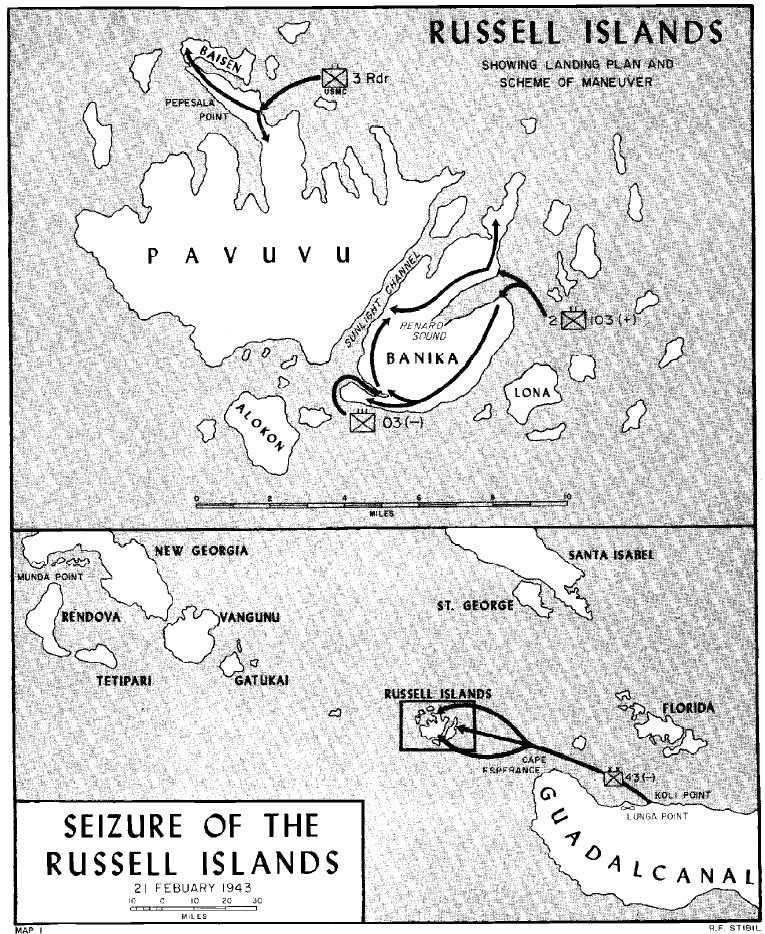
Map 1: Seizure of the Russell Islands: 21 February 1943
force. The precautions paid off; no enemy scout plane or vessel spotted the task force and the landing was made without opposition.
Reconnaissance parties sent to the Russells several days before the landing had selected suitable beach exits, gun sites, and camp and dump areas. On the morning of the 21st, the Army battalions landing on the two beaches of Banika and the Marine raiders going ashore on Pavuvu’s Pepesala Point were met by guides who led them to preselected positions. One hour after the waves of assault troops landed from their destroyer transports, the LCTs nosed ashore and began unloading. The first echelon of antiaircraft guns and crews of the 11th Defense Battalion were in position on Banika by noon. The raiders and infantrymen were dug in to meet a counterlanding attempt before nightfall.
Marine antiaircraft gun crews and the Army field artillerymen whom they had retrained for the air defense job10 were the only ones to see action during the ensuing weeks. On 6 March, the first Japanese attack occurred when a dozen fighters and bombers made a low-level strike on the main islands. Early warning radar was not yet in operation and the first enemy bombing and strafing run caused some casualties before the antiaircraft defenses were manned; at least two enemy raiders were shot down. Sporadic air attacks followed this first effort, but none were of serious import.
The Marine elements of the original CLEANSLATE landing force were only temporarily assigned to the operation. The 11th Defense detachment was used only until the 10th Defense Battalion arrived in the Russells; on 15 March, the new unit began taking over the 11th’s battery positions. The changeover was completed by 17 March, and the detachment’s gun crews returned to Port Purvis on Florida Island the following night. The 3rd Raider Battalion pulled out on 20 March and returned to Espiritu Santo; 43rd Division units occupied the raiders’ defensive positions.
The withdrawal of the Marines was about the only rearward movement of troops from the Russells during this period. Each day after D-Day, LCTs loaded at Guadalcanal and under cover of darkness made the run to the new forward base; succeeding echelons of Turner’s task force arrived at the islands for 50 nights running. By the end of February over 9,000 men were ashore and by 18 April, when responsibility for logistic support and defense of the Russells passed to the commanding general at Guadalcanal, 16,066 men and 48,517 tons of supplies had been brought in by the LCT shuttle. Banika now boasted an operating airfield for MAG-21’s three fighter squadrons, a motor torpedo boat base, extensive base defense installations, and the start of a considerable supply handling capacity.
Admiral King in Washington was somewhat dubious of the value of putting so much into the Russells, but Halsey defended his policy as necessary for the protection of the new air base. As far as ComSoPac was concerned, CLEANSLATE was merely the completion of the first stage of his move toward New Georgia, and the troops and supplies stationed there were earmarked for the continued advance up the Solomons chain.
Battle of the Bismarck Sea11
While ComSoPac was consolidating his hold on the new Russells airdrome, an event occurred in the Southwest Pacific Area that emphasized dramatically the importance of land-based air in the campaign against Rabaul. On 2-3 March, a Japanese troop convoy headed for Lae at the base of the Huon Peninsula was engaged in a running fight by Australian and American squadrons based on New Guinea. The results of this Battle of the Bismarck Sea were so significant that General MacArthur stated:
We have achieved a victory of such completeness as to assume the proportions of a major disaster to the enemy. Our decisive success can not fail to have most important results on the enemy’s strategic and tactical plans. His campaign, for the time being at least, is completely disrupted.12
The convoy was an attempt initiated by Eighth Area Army to strengthen its defenses in the Lae-Salamaua area and to insure continued control of both shores of Dampier Strait. Eight transports, varying in size from 500 to 6,800 tons, and eight escort destroyers made the run. On board were approximately 6,000 soldiers of the 51st Division and 400 replacements for Special Naval Landing Force units.13 A canopy of fighter planes, both Army and Navy, was provided for overhead protection.
The enemy convoy cleared Rabaul on 1 March, steaming at slow speed along the northern coast of New Britain, partially hidden by lowering skies which made observation difficult. A reconnaissance bomber of MacArthur’s Fifth Air Force sighted the ships and escorting fighters, however, and radioed in its find; a flight of B-17s was unable to locate the target when the weather closed. The following morning the convoy was spotted again and this time the Flying Fortresses found their quarry, broke through the screen of planes and antiaircraft fire, and sank one transport, the 51st Division command ship. Survivors were transferred to two destroyers, which separated from the main convoy and steamed ahead to Lae. Australian and American planes continued to seek out the ships throughout the day, but the continued bad weather helped to foil these attacks and further damage was minor.
Despite the aerial harassment, the Japanese adhered to their original sailing schedule, which was to bring them off Lae about 1700 on 3 March. By early morning of the 3rd, the convoy was well within Huon Gulf and also well within range of Allied airbases on New Guinea; for all practical purposes the enemy had sailed into a trap. MacArthur’s air commander, Major General George C. Kenney, sprang it with a coordinated attack led by low-level fighter-bombers specially practiced in
antishipping strikes, backed up by medium- and high-level bombers and an escort of fighters. The resulting melee was disastrous for the Japanese. Every transport was burning and in a sinking condition in less than half an hour; two destroyers were sunk and a third heavily damaged. The attacks continued until a fourth destroyer, engaged in rescue operations, was hit that afternoon. Motor torpedo boats reached the scene during the night and finished off one of the cripples, and the next morning the bombers completed the score. After rescuing 3,800 men, four destroyers, all that was left of the original convoy, made it back to Rabaul; fewer than 900 men got through to Lae.
The overwhelming Allied success had, as General MacArthur observed, important results. Not only did the Japanese fail to get a substantial reinforcement through to the Huon Peninsula area, but the transport losses forced them to abandon large-scale reinforcement attempts altogether. Dampier Strait did not belong to the Allies yet, but Kenney’s fliers made it clear that the Japanese had no clear title either. Supplies and men slated for enemy garrisons in Eastern New Guinea or the Solomons—for any base within effective range of Allied planes—were now moved forward by destroyers, whose high speed, excellent maneuverability, and antiaircraft guns gave them a measure of protection, or by small craft hugging the island coasts. The Japanese had been decisively defeated, but a battle is not the war, and the sorry record of their defending aircraft prompted an all-out effort to restore at least a parity of airpower in the Rabaul strategic area.
Japanese “I” Operation14
Following the Bismarck Sea debacle, Japanese scout planes reported increased activity in Papua and the lower Solomons. Allied troop and material strength was clearly increasing, and all intelligence pointed to the imminence of offensive operations. Allied air raids and antishipping strikes seriously disrupted enemy defensive preparations and curtailed the movement of reinforcements to forward bases. The Japanese decided that a strong counter-stroke was needed to blunt the Allied air spearhead and to gain a respite for their own defense build-up. Tokyo assigned the task, designated I Go (“I” Operation), to Admiral Yamamoto and his Combined Fleet.
In order to bolster the strength of Rabaul’s Eleventh Air Fleet, Yamamoto ordered forward from Truk the planes and pilots from four of the carriers of his Third Fleet. On 3 April, the admiral himself flew to Rabaul to take personal command. The combined force available for I Go was at least 182 fighters, 81 dive bombers, and 72 medium-range land bombers, plus a few torpedo planes. The 15-day operation was planned to proceed in two phases, the first incorporating a strike against the Solomons and the second, attacks on Allied positions in Papua.
The busy cluster of ships, large and small, in the vicinity of Tulagi and Guadalcanal was the initial I Go target. Near noon of 7 April, 67 enemy Val dive bombers with an escort of 110 Zeke fighters
took off from staging airfields on Buka and Bougainville to make the attack. Their departure was duly noted and reported to Henderson Field by coastwatchers on Bougainville; at 1400, radar in the Russells picked up the oncoming flights and 76 interceptors, Guadalcanal’s typical joint-service mixture, scrambled and tangled with the Zeke escort over The Slot. The Japanese bombers, hiding behind a blanket of heavy black clouds that covered Indispensible Strait between Malaita and Florida, headed for Tulagi. Almost all the ships were out of Tulagi harbor when the raiders struck; only a fleet oiler and a New Zealand corvette were caught in the confined waters. Both were sunk. The attack continued against the rapidly maneuvering vessels in Iron Bottom Sound, but ship and shore antiaircraft fire kept the Vals high and the bombing inaccurate. The destroyer Aaron Ward, attempting to protect an LST that had become the focus of enemy attention, was seriously damaged; she later sank under tow. The bombers caused no other significant damage and drew off soon after they loosed their loads. The Zekes scored just as lightly as the Vals, accounting for only seven planes, all of them Marine. The welter of conflicting claims for enemy aircraft shot down was winnowed to an estimate that less than 25 Japanese were lost,15 a figure that argued well with the highest official enemy report of 24 planes downed.16
Aside from the relatively light damage to Allied ships and aircraft, the 7 April attack had one other tangible result for the Japanese. It enabled them to slip reinforcements into Kolombangara by destroyer transport while ComSoPac concentrated his air strength at Guadalcanal to meet further attacks. Similar reinforcement efforts were executed for Western New Britain and the Huon Peninsula under cover of the trio of attacks on New Guinea targets that made up the second phase of I Go.
On 11 April, 94 Third Fleet carrier planes attacked shipping in Oro Bay, 20 miles southeast of Buna. Fifty Allied fighters fought them off but not before Japanese Val pilots had sunk one merchantman, beached another, and damaged an Australian minesweeper. On the following day, 174 Japanese naval planes, including 43 medium bombers, made a mass attack on the airfields surrounding Port Moresby. While defending fighters took on the Zeke escort, the bombers plowed up the airstrips, but otherwise did little damage. The third I Go raid was made on ships and airfields at Milne Bay on 14 April. The Japanese again attacked in overwhelming force, 188 planes; only 24 Australian fighters were available to meet them, but all ships were forewarned and underway, firing their antiaircraft guns to make the enemy pilots shear off. The major result of the attack was the sinking of a merchantman and some minor damage to other shipping. In all three attacks, 5 Allied planes were lost, and the Japanese admitted the loss of 21 aircraft.
On 16 April, Admiral Yamamoto called off the “I” Operation, ordering the remaining Third Fleet planes back to Truk. He had been completely misled by the glowing reports of his pilots into believing that I Go had been a tremendous success. The total damage claim for the four raids was
staggering: 1 cruiser, 2 destroyers, and 25 assorted transports and cargo vessels sunk, with heavy damage to 2 more transports and several smaller vessels; 134 planes shot out of the air (including 39 probables). Matched against these totals was the actual loss of 1 destroyer, 1 corvette, 2 merchantmen, and less than 20 aircraft. It would seem that the Third Fleet pilots had adopted the penchant for reporting “gross exaggeration of damage inflicted” that was rampant in the ranks of the Eleventh Air Fleet.17 Whatever the explanation for pilot error, be it willful exaggeration or wishful thinking, the premature ending of I Go without any significant results was chilling to Japanese hopes of delaying Allied offensive preparations.
Allied Raids18
The prime targets of Halsey’s pressure tactics in the early months of 1943 were the enemy airfields at Munda on New Georgia and Vila on Kolombangara. The tempo of air raids against these bases increased steadily as Allied strength mounted. Coupled with these air strikes was a limited program of naval bombardment made possible by the fact that SoPac planes and ships had wrested control of the waters immediately north of Guadalcanal from the Japanese. The Japanese could and did risk their warships within range of Henderson Field’s bombers, but the need had to be great as in the evacuation of Guadalcanal. The chance for a showdown sea battle still brightened the hopes of enemy naval officers, but there was little desire any longer to seek this critical fight in the confined waters of the lower Solomons. Halsey’s cruisers and destroyers had time to get some experience at shore bombardment, thus exposing enemy garrisons to a bit of the bitter medicine dished out by Japanese naval gunners in the darkest days of the struggle for Guadalcanal.
Rear Admiral Walden L. Ainsworth took a cruiser-destroyer force against Munda on 5 January and again on the 24th brought his bombardment group up to New Georgia, this time to shell the field at Vila. On both occasions, fires started by naval gunfire lit up the night and the results of the bombardment were at least spectacular. Follow-up attacks by Allied air caused more damage, according to the Japanese, but neither bombing nor shelling had any lasting effect on the progress of the enemy airbase construction. Admiral Ainsworth noted that, while these air-sea attacks might render the fields unusable for critical periods of time, “the only real answer is to take the field away from them.”19
Admiral Halsey was in complete agreement with this sentiment; he expected little more from his attack pattern in the Central Solomons than the harassment and delay he achieved. The Japanese became expert at filling in the craters in the runways and dug-in their scattered dumps and shelters to minimize the effect of the Allied raids. Life was mighty unpleasant under the constant round of attacks, however, and the portents were hardly encouraging for the success of Japanese arms.
Another of Ainsworth’s shore bombardment groups was underway for New Georgia after dark on 5 March when he received
word from Guadalcanal that two enemy ships had left Bougainville headed south earlier in the day. Guadalcanal’s seaplane scouts spotted the ships, two destroyers that had just delivered supplies to the Vila base steaming north on a return course. Fire control radar screens pinpointed the location of the targets for ships’ batteries, and the enemy vessels were buried in a deluge of shells. Both quickly sank; only 49 crewmen survived to tell their harrowing tale to the garrison on Kolombangara.20
The cruiser-destroyer force was slated to hit Munda and Vila again on the night of 7-8 April and was already out of port when Admiral Yamamoto launched his “I” Operation with the assault on Tulagi. The Japanese planes failed to sight the bombardment ships, but the prospect of further enemy attacks prompted Halsey to call off the mission and concentrate his forces. The temporary slackening-off of surface and air raids made necessary by this assemblage of power may have been instrumental in convincing Yamamoto that I Go was a success. The enemy admiral had no time to discover his mistake.
On 18 April, two days after Yamamoto ended I Go, he left Rabaul with his staff on an inspection trip to Bougainville. As a result of a message intercept, Allied intelligence knew the itinerary of the inspection party and a killer group of Army long-range fighters from Henderson Field met the Japanese planes over their destination, Buin airfield. The execution was swift and sure; a few moments after the interceptors attacked, the staff transports crashed in flames and the enemy’s most famous naval commander was dead. Yamamoto died primarily because Nimitz’ staff evaluated him as the best man the Japanese had to command their Combined Fleet; had he been less competent, less of an inspiration to enemy morale, he might well have lived. His death dealt a telling blow to the spirit of the defenders in the Solomons, and furnished grim warning of the downward course of Japanese fortunes.