Footnotes
Part III: The Palaus: Gateway to the Philippines
Blank page
Chapter 1: Strategic Situation1
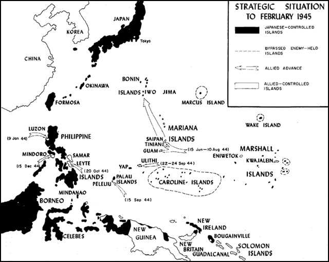
Most American planners agreed by early 1944 that the next important goal in the increasingly successful war against Japan was to secure a base in the strategic triangle formed by the Philippines, Formosa, and the coast of China. Such a move would sever the lines of communication between Japan’s home islands and her rich conquered lands in the Netherlands Indies and Southeast Asia. Moreover, the plan envisaged sites for long range bomber airfields, as well as a valuable base from which future invasions, including the ultimate assault of Japan itself, could be mounted. After much debate over the proper avenues of advance, the Joint Chiefs of Staff agreed to a compromise which would set in motion a two-pronged attack along the two most practicable routes of approach: one through the Central Pacific, and the other along the New Guinea-Mindanao axis originating from the Southwest Pacific. Both of these offensives were well advanced by the summer months of 1944. By a series of amphibious landings, General Douglas MacArthur’s Southwest Pacific Area forces had reached the western extremity of New Guinea. As a result, the island was neutralized as a base for enemy operations, and the way was cleared for a move against Mindanao (See Map 1). In the Central Pacific, meanwhile, troops controlled by Admiral Chester W. Nimitz, Commander in Chief, Pacific Ocean Areas (CinCPOA) had seized Saipan and consolidated their hold on the Marianas. When these two avenues of attack converged in a pincer movement on the Philippines, the
planned encirclement of bypassed Japanese bases would be complete, and the Central Pacific for all practical purposes would be turned into an American lake. First, however, thought had to be given to the safeguarding of MacArthur’s invasion route north from New Guinea.
Some 530 miles directly east of Mindanao lay Japan’s main bastion in the Western Carolines, the Palau Islands. General MacArthur believed that he could not mount an amphibious campaign against the Philippines unless this potential threat to his lines of communications was eliminated. It appeared that land-based aircraft could not neutralize this danger, for the enemy stronghold was too far distant from newly-acquired bases for sustained and effective air attacks. Permanent neutralization of the Palaus, Pacific planners decided, could be gained only by amphibious assault.
Although three excellent targets stood out in the Western Carolines—the Palaus’ airfields and anchorages, Yap’s air base, and Ulithi’s exceptionally spacious and deep anchorage—the high level planners envisioned, at first, only the seizure of the Palaus. This undertaking was given the rather prophetic code name of Operation STALEMATE, for revisions, postponements, and drastic changes characterized it right up to the moment of actual consummation. Before the campaign initiated by STALEMATE was ended, all three of the targets were to be included in its operation plans, although only the islands of Peleliu and Angaur in the southern Palaus and the Ulithi Atoll actually would be invaded.
As Admiral Nimitz later explained, the reasons for STALEMATE were twofold: “first, to remove from MacArthur’s right flank, in his progress to the Southern Philippines, a definite threat of attack; second, to secure for our forces a base from which to support MacArthur’s operations into the Southern Philippines.”2 On the same day proposed for the landing on Peleliu, infantry units of the Southwest Pacific command would assault the island of Morotai in the Moluccas, thus securing MacArthur’s left flank and providing him with a suitable airfield site for land-based aircraft to support his invasion armada mounting from New Guinea.
Whether or not the Palau Operation was a necessary prerequisite for MacArthur’s return to the Philippines remains a matter of unproductive speculation. Except for those who participated in it, Peleliu largely remains a forgotten battle, its location unknown, its name calling forth no patriotic remembrance of self-sacrifice or gallant deeds as do the battles of Guadalcanal, Tarawa, and Iwo Jima. For the Marines who stormed ashore on Peleliu, however, the strategic value of the island may not have been clear, but duty was. They had been given a job to do, and they went ahead and did it. As Major Frank O. Hough, a veteran of the fighting on “Bloody” Peleliu, commented:–
Whatever might have been, the Marines hit the Peleliu beaches on 1.5 September 1944, and history records that nine days after the assault phase was declared at an
Strategic Situation to February 1945
end, MacArthur invaded Leyte. For better or for worse, his flank had been secured, and with the action which followed the Pacific War entered a new and decisive phase.3
Geographical and historical background4
As the westernmost extremity of the vast Carolines Islands chain, which spans some 33 degrees of longitude across the Pacific Ocean just north of the equator, the Palaus lie roughly 500 miles from both the Philippines to the west and New Guinea to the south, and 240 miles from Yap to the east. This remoteness, especially from the rest of Micronesia, long retarded the islands’ development and delayed knowledge of their existence to the outside world.
Although Ruy Lopez de Villalobos is generally credited with the discovery of the Palaus in 1543, the first recorded visit to the island was made in 1712 by Spanish missionaries. Afterwards, Spain was to maintain a shadowy claim of ownership over the Palaus and the rest of the Western Carolines; yet she made no real attempts at the economic development or social improvement of them. Except for visits by English ships in 1738 and 1791, the Palaus remained unknown to the Western World until the middle of the 18th Century when trading ships plying the Chinese market rediscovered them.
By 1885, Spain’s long failure to develop the Western Carolines encouraged Imperial Germany, anxious at this time for overseas colonies to supplement her rapidly growing industrial factories, to land naval forces at Yap and take possession. This challenge to Spanish sovereignty proved fruitless, for a neutral arbitrator soon disallowed the Germans’ claim to the disputed islands. In 1899, however, Spain suddenly decided to withdraw completely from the Pacific area; she wanted no more territorial losses such as she had suffered in the Spanish-American War. As a result, she sold the Carolines, Marshalls, and Marianas to the Germans, who immediately began to exploit the islands with vigor. By 1914, this exploitation had provided the Palaus with a telegraph station and modernized transportation facilities. In addition, the mining of phosphates and the production of copra had been initiated.
At this point, the outbreak of World War I gave Japan a golden opportunity for expanding into the Central Pacific. Quickly joining the Allies, she organized naval expeditions and set about
seizing Germany’s Pacific possessions. This energetic land-grab was more or less legitimized after the war, when the new League of Nations granted Japan a mandate over the former German colonies north of the equator. After their abrupt withdrawal from the League in 1935, the Japanese continued exercising a de facto sovereignty over the Palau Islands, as well as the rest of the mandated islands.
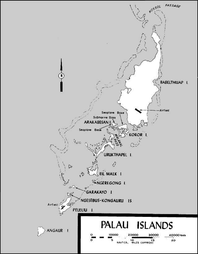
Geographically, the Palaus consist of several large islands and well over a hundred smaller ones, extending generally in a northeast-southwest direction for nearly 100 miles (See Map 2). Except for Angaur in the south and two small atolls in the north, the whole group lies within a great encircling coral reef which is largely a barrier reef on the west and a fringing reef on the east. The maximum width between the outer reefs is about 20 miles, and the whole island group covers approximately 175 square miles. All of the islands are irregularly shaped and most are hilly, but they vary greatly in physical character, ranging from flat atolls in the north to volcanic central islands and, finally, to coral-limestone islands in the south.
Lying only a few degrees above the equator, the Palaus have a humid and hot climate typically equatorial, and the seasons are monotonously uniform and unchanging. In any month, the rainfall is rarely less than 4 inches, and the mean monthly temperature is seldom less than 80 or more than 82 degrees Fahrenheit. While temperatures are not excessively hot, the relative humidity (82%) remains high at all times and is most discomforting and debilitating. Also typical of equatorial conditions are the threats to health caused by dengue and dysentery; strangely enough, however, malarial mosquitoes are not present in the Palaus. During the fall season (September-November), westerly winds predominate, and there are usually three heavy thunderstorms a month, while typhoons are an ever-present threat. In addition, these fall months normally have 18 to 20 rainy days, the average rainfall for any one month being just over 10 inches. Visibility is usually good, however, with mean monthly amounts of cloud cover varying from four-tenths to six-tenths. Fogs are rare and mists infrequent.
The natives inhabiting these equatorial islands are basically Micronesians, a racial blend of the lighter Polynesian and the darker Melanesian stocks. Physically, however, Palauans most nearly resemble the Malay people of the Netherlands Indies, probably because of interracial mixing that occurred as the result of an eastward seaborne immigration of the Malays. The Palau language shows obvious Malayan influences also. In fact, Americans found great language and cultural differences between the people of the Western Carolines and those whom they encountered in Micronesia.
Like other native ethnic groups in the Pacific islands, the Palauans suffered a population decline following the coming of the white man, usually as a result of his diseases. From an estimated 40,000 in 1800, the number of Palauans had shrunk to a pre-World War II total of 6,500. An estimated 20,000 Japanese civilians, who had emigrated from the
Palau Islands
Home Islands prior to the war, lived in the Palaus. As a result, a certain intermingling of Japanese and Palauan blood lines occurred.
While the natives enjoyed an adequate food supply due to the islands’ staple taro crop, large quantities of rice had to be imported from the Home Islands each year to feed the numerous Japanese living there. Fish from the surrounding waters, of course, provided an important dietary supplement. The only agricultural export produced by the natives was copra, but the extensive phosphate deposits on Angaur and Peleliu supplied the Palaus’ most valuable export. Trade between the various islands and the outside world was restricted by the Japanese almost solely to the Home Islands.
The principal islands in the Palau chain from north to south are Babelthuap, Koror, Arakabesan, Malakal, Urukthapel, Eil Malk, Peleliu, and Angaur. Larger than all others combined, Babelthuap has a rugged interior with heights up to 800 feet, and is covered with a typical rainforest growth. Just north of the large island lies Kossol Passage, a valuable naval anchorage because of its spacious reef enclosed area with a coral and sand bottom. Centrally located and near the best anchorages and harbors, the town of Koror on the island of the same name is just to the south of Babelthuap. Under Japanese rule, it functioned as the commercial, administrative, and communication hub for the island group, as well as governmental headquarters for the entire mandated territory. It was, however, the southernmost islands, Peleliu and Angaur, upon which the attention of the American planners came to focus.
Located just inside the southwest tip of the huge Palau reef, Peleliu is an oddly shaped island with two elongated arms of land. Often described as resembling the claw of a lobster, this coral-limestone island is approximately six miles long, is aligned in a north-south direction, and has a maximum width of slightly more than two miles. The relatively flat and wide southern section contrasts sharply with the northern elongated arm which is dominated by an irregular series of broken coral ridges, narrow valleys, and rugged peaks. The key terrain from a military viewpoint, this ridge system derived its name from the 550-foot Umurbrogol Mountain. Literally honeycombed with natural caves, a nightmare of crags, pinnacles, and coral rubble, this type of terrain lends itself well to defensive tactics (See Map 3).
To the east, Peleliu’s other peninsula soon tapers off into a series of smaller islets, separated from each other and the longer northern arm by a complex of swamps and shoal coral. This eastern arm of land extending out from the southern portion of Peleliu is virtually separated from it by a tidal coral flat choked with mangroves. The southernmost part of the island, on the other hand, terminates into two promontories with a cove between. The southwestern promontory, sometimes called Ngarmoked Island, is larger and more rugged than the southeastern one, which is connected to the mainland only by a narrow spit of sand.
The island is heavily wooded with a thick scrub jungle growth, and on the
thin topsoil of the Umurbrogol ridges grew a sparse, scraggly vegetation that cloaked the contours beneath and defied all attempts of preinvasion aerial reconnaissance. A dense tropical growth thrives along most of the island’s shores, with mangrove swamps bordering the northeastern beaches. The island has no rivers or lakes, and except for a few swamps, its soils drain within a few hours after a heavy rainfall. For their water supply, Peleliu’s inhabitants depended chiefly upon rain water stored in cisterns.
Amphibious planners found no dearth of suitable beaches on Peleliu, for landings were feasible at almost any point, providing the reef was passable. Along the east coast is a narrow reef which borders the shoreline, except to the south where small bays occur, and to the north where the reef lies 1,200 to 5,000 yards offshore. On the western side of Peleliu, there is a broad, shallow reef shelf, varying in width from over a mile in the north to 400 yards in the south. The outer part, somewhat higher than the inner portion, was strewn with boulders. At a few points, there are breaks in the reef, where restricted channels permit passage of small boats at high tide. The northern part of the reef is from 1,400 to 1,600 yards offshore, while in the south it averages 500 yards. During the fall months, the west shores of Peleliu receive only a light to moderate surf, and the mean range of its tides is from 3.3 to 3.9 feet.
The beaches on the western side, the best in terms of amphibious assaults, are extensive. Composed of coarse textured coral sands, they are trafficable at all times, particularly when wet. Their surface is generally rough and rubbly, with much coral debris lying about. The slope of the beaches is usually moderate to steep, and passage inland encounters, in general, only moderately rising wooded areas.
The main military value of Peleliu, and of the Palaus, lay in its southern lowlands, where the Japanese had already built two unusually good runways in an X pattern. Surfaced with hard-packed coral, this airfield was suitable for bombers and fighters, and was served by ample taxiways, dispersal areas, and turning circles. A scrub jungle, interspersed with wild coconut trees and an occasional grassy clearing, flanked the field on both the west and south, while a dense mangrove swamp bordered it on the east. To the north was an extensive area of buildings, and right behind them began the sharp ridges of the Umurbrogol system, which were to prove such an ideal position for the defenders. Also of military interest was the auxiliary fighter strip in the process of being constructed on Ngesebus Island, which lay off the northern tip of Peleliu, connected by a wooden causeway across a shallow reef to the mainland.
The Japanese airfield, near the village of Asias, was the central focus of Peleliu’s road system. From the airfield, the West and East Roads ran up the northern peninsula, flanking the Umurbrogol highlands. In the north where the ridges flatten out briefly, these two roads converged into one that continued to the northernmost tip of Peleliu and the village of Akalokul, site of a phosphate crushing plant and a hand-operated, narrow-gauge railroad.
About half way up the West Road, near the village of Garekoru, a trail angled across the ridges to link up with the East Road. From Asias, a road ran northeast across the narrow causeway and up the eastern peninsula to Ngardololok, where the Japanese had set up a radio-direction finder, a power plant, and a few other military installations. A southern extension of the East Road served the promontories to the south.
The other island attracting the attention of American planners was smaller and more compact than Peleliu. Angaur is the southernmost of the Palau Islands and lies outside of the complex of reefs surrounding them. The island is composed of raised coral and is shaped somewhat like a half-moon, with its concave side facing to the west. Approximately 5,000 yards north to south and nearly 4,000 yards at its maximum width, Angaur has an estimated area of 2,000 acres. Its highest elevation, about 200 feet, is in the more rugged northwest corner, and there are steep 20- to 40-foot cliffs along much of the shoreline. The remainder of the densely wooded island, however, is almost flat, and its capability of being readily transformed into a heavy bomber site made it a military objective worthy of seizure. Barriers to overland movement were the dense jungle growth, swampy areas inland, steep cliffs, two small lakes formed by water collecting in abandoned phosphate diggings, and the broken ridges of the northwest corner.
Several excellent beaches for landing operations occur on Angaur, with movement immediately inland hampered only by the rainforest and thick undergrowth. Where reefs fringe the coast, they are generally narrow and drop off sharply into deep water. A sheltered water area exists on the west side near the village of Saipan. The port and trade center of the island, this village was connected with the other coasts by roads, trails, and narrow-gauge railway lines.
Two other potential targets, besides the Palaus, also played an important role in the evolution of STALEMATE: Yap Island and Ulithi Atoll. Yap, actually a cluster of islands grouped together on a triangular reef, possessed a well-developed and strongly garrisoned Japanese airbase. None of Ulithi’s some 30 islands, on the other hand, was considered suitable by Japanese engineers for the construction of an airstrip, and the atoll was only lightly held. Ulithi, however, possessed an excellent sheltered anchorage, and occupied a central position in respect to other Pacific islands the Americans had seized or intended to seize. After its capture, it was destined to become the vital hub of naval operations in the Western Pacific during the last days of the war.
Operation STALEMATE II5
Initial Allied planning for the capture of the Palaus started during the First
Quebec Conference (QUADRANT) in August 1943. During this top level meeting, a tentative date of 31 December 1944 was fixed for the assault on the Palaus; the campaign would follow the seizure of the Marshalls and Truk, but precede the attack on the Marianas. Subsequent strategic revisions, however, provided for the bypassing of Truk and the capture of the Palaus in September following the occupation of Saipan, Tinian, and Guam. This new schedule was formulated by the Joint Chiefs of Staff directive of 12 March 1944.
Preliminary steps, meanwhile, had already been initiated by top Pacific commands. A Marine general, passing through Pearl Harbor on his way to the front in January 1944, found the Planning Section of CinCPOA Staff, headed by Colonel Ralph R. Robinson, USMC, far advanced in its preparation for a future assault of Babelthuap. In fact, the general noted that the planners were utilizing the same landing area as used by a Marine Corps Schools problem in the thirties.6 A month later, Joint Intelligence Center, Pacific Ocean Areas distributed a bulletin setting forth what was then known about the Palaus. This was little enough, for such convenient intelligence sources as coastwatchers and trading ships’ captains, often available in earlier campaigns, were totally lacking. Until the Americans actually landed in the Palaus, any terrain studies of the islands would have to be made solely from aerial or submarine reconnaissance.
Operation STALEMATE was formally launched on 10 May, when Admiral Nimitz issued the Joint Staff Study for the Palau Operation. This study contained the general organization of the forces to be employed, the allocation of ground, air, and naval units, the scheme of maneuver, and the logistic support plan. The date for the landing was tentatively set for 15 September 1944. As copies came into the hands of the assault and support echelons concerned, detailed planning began immediately. The planning for the Marianas campaign was minutely scrutinized, with a view of profiting from previous errors and of eliminating all unnecessary detail from the plans of each subordinate command.
This flurry of activity among the staffs of the various Pacific commanders accelerated appreciably on 29 May, when CinCPOA promulgated a warning order envisioning the capture of the entire Palau Group with a target date of 8 September. This ambitious undertaking, larger in scale than any previous Pacific operation, would employ four assault divisions, organized into two corps.
Earlier, on 7 April, while in Pearl Harbor in connection with the planning for the Marianas Operation (FORAGER), Major General Roy S. Geiger, Commanding General, III Amphibious Corps (IIIAC), had been forewarned by Nimitz that his corps would participate in the coming Palau campaign. Immediately upon his return to Guadalcanal and in spite of the scarcity of available information, General Geiger had his staff institute a study of the Palaus, concurrent with its planning for the close-at-hand Guam assault.
Just prior to embarking for the Marianas, Geiger detached a provisional planning staff from IIIAC and sent it to Pearl Harbor, where it became operative on 12 June. Initially headed by Colonel Dudley S. Brown and charged with the planning for the seizure of the Palaus, this group was later redesignated X-Ray Provisional Amphibious Corps, and Major General Julian C. Smith, who possessed sufficient rank and seniority to sustain Marine Corps views in subsequent planning conferences, was placed in command. At this time, General Smith was stationed in Pearl Harbor as Deputy Commander, V Amphibious Corps, and he was to fill both positions for some time.
Because so many echelons had staffs located in the Pearl Harbor area, planning for the Palau campaign benefited from a closer coordination between the various assault and support commands than was customary in similar operations, Right from the start, however, complications arose to plague the planners and high echelon commanders. Unbeknown to them, STALEMATE plans were to wend an involved and tortuous path and undergo numerous revisions before actual consummation.
The troop basis for the Palau Operation had been predicated upon the use of units already slated for the Marianas, a campaign that proved more difficult and time-consuming than originally estimated. As a result, units earmarked for STALEMATE had become deeply involved in the Marianas fighting. Unless the landing was delayed, it would be impossible to re-equip and ready these forces in sufficient time to meet the deadline of 8 September. Accordingly, CinCPOA directed, on 29 June, that such substitutions or improvisations be made as necessary for the execution of the Palau campaign.
Such last minute shifts of troop assignments, however, did not resolve the problem of insufficient forces. By early July, planners were becoming disturbed by reports that alarming increases in the enemy forces garrisoning Babelthuap and the other islands were occurring. Doubts were voiced about the adequacy of a two-division landing force for the large island. After all, it had taken three divisions 25 days to secure the smaller and less rugged Saipan.
Questions were raised also about the suitability of Babelthuap’s terrain for airfield construction, hitherto a contributory reason for its being a target. Peleliu, on the other hand, already had a fine airfield and an auxiliary fighter strip under construction on offshore Ngesebus. Their seizure and rapid development as a base for American planes would permit neutralization of the remaining Japanese-held Palau Islands
without the need of actually invading them. In addition, the small island of Yap, Palaus’ nearest neighbor, already possessed a good airbase and was a much easier target than Babelthuap.
Although its anchorage facilities was another reason for Babelthuap’s capture, the excellent and spacious fleet anchorage at Ulithi Atoll was available at little cost, as the Japanese had only a handful of soldiers outposting it. The substitution of Yap and Ulithi for Babelthuap, with its unfinished airfields and fair anchorage, would provide instead a good operative airbase and a superb fleet anchorage.
Other factors added complications to the STALEMATE planners. Shipping allocated to the Palau Operation was heavily committed to the slow-moving Marianas campaign, as were the available fire support ships. Then in mid-June, the Joint Chiefs of Staff queried the top Pacific commanders as to the possibility of bypassing the Western Carolines completely in exchange for a speedup of the Pacific timetable and an earlier strike at Formosa, or even Japan itself. Only one answer was in the affirmative, that of Admiral William F. Halsey, but the changed strategic picture in the Central Pacific at this time did bring about a radical revision of the proposed Palau Operation.
After a re-examination of the situation, Nimitz cancelled the original Palau concept in favor of a much less ambitious venture. The southern islands of Peleliu and Angaur would still be seized, but the atolls of Ulithi and Yap, known to be easier targets, would be substituted for Babelthuap.
On 7 July, a new warning order was forwarded to all subordinate commands, replacing the earlier one of 29 May. The overall operation, under the new designation of STALEMATE II, was to be a two-phase assault carried out by two separate landing forces. Phase I would consist of the capture of the Southern Palaus and the neutralization of the Babelthuap and Koror areas, while Phase H would involve the seizure of Yap and the Ulithi Atoll. The target date for Phase I was postponed to 15 September 1944, thus coinciding with the assault on Morotai, and the date for the initiation of Phase II was established tentatively as 5 October.
Overall command for the operation resided in Admiral Halsey as Commander, Western Pacific Task Forces. The combat ships of his Third Fleet were to cover the approach of the Joint Expeditionary Forces to their objectives. In addition, he was expected to furnish naval support for the Southwest Pacific Forces simultaneously assaulting Morotai while, in return, General MacArthur’s air would aid in the preinvasion softening up of the Palaus and other air support missions.
Incidentally, out of this planning by Central and Southwest Pacific air liaison officers for STALEMATE II came a most closely coordinated, integrated, and far-reaching series of strategic air support missions. The major objective of the combined operation–gaining control over the eastern approaches of the Luzon-Formosa-China coast area—caused the air planners to widen the scope of the proposed air activities to a degree not encountered in any previous Pacific amphibious undertakings.
The magnitude of Halsey’s task is still difficult to imagine. Upon his Third Fleet fell the duty of transporting and protecting the landing forces en route to the target, furnishing the necessary naval gunfire and air support, plus such related support missions as supplying the troops ashore after a beachhead was secured. Before STALEMATE II was over, every major command in the Pacific participated in it, and it eventually involved 800 vessels, 1,600 aircraft, and an estimated 250,000 Navy, Army, and Marine personnel. As the largest naval amphibious venture thus far in the Pacific, the attacking force alone included 14 battleships, 16 carriers, 20 escort carriers, 22 cruisers, 136 destroyers, and 31 destroyer escorts, not counting the numerous types of landing craft or service ships, nor the support ships for the Morotai landing. Supplying such a vast and complicated assortment of men and ships taxed the logistic support of all available Allied commands.
In order to handle adequately the job of shepherding the troop transports and attached vessels to their destination, plus fulfilling related support missions, Admiral Halsey was forced to divide his powerful Third Fleet into two parts. He retained direct control of the Covering Forces and Special Groups (TF 30), and Vice Admiral Theodore S. Wilkinson commanded the Third Amphibious Force (TF 31). For direct support of the landings, TF 31 was further divided into the Eastern Attack Force (TF 33), scheduled for the Yap- Ulithi assaults, and the Western Attack Force (TF 32), which would cover the Peleliu and Angaur operations. Admiral Wilkinson retained direct control of TF 33, but delegated control of TF 32 to Rear Admiral George H. Fort. This latter force was again divided into the Peleliu Attack Group (TG 32.1, under Fort’s tactical control), the Angaur Attack Group (TG 32.2, Rear Admiral William H. P. Blandy), and the Kossol Passage Detachment (TG 32.9, Commander Wayne R. Loud), which had the mission of sweeping the area free of mines and organizing it as a temporary fleet anchorage and seaplane base.
Although the U.S. Navy had the task of transporting, protecting, and landing the assault troops, the man designated to control all ground action for Operation STALEMATE was Major General Julian C. Smith in his role as Commanding General, Expeditionary Troops. Immediate control would be exercised by his subordinate Western and Eastern Landing Forces. The Western Landing Force and Troops, Major General Geiger’s IIIAC, would seize Peleliu using the 1st Marine Division (Major General William H. Rupertus) and complete Phase I by capturing Angaur with the 81st Infantry Division (Major General Paul J. Mueller, USA). Phase II, the seizure of Yap and Ulithi, was assigned to the Eastern Landing Force and Troops, commanded by Major General John R. Hodge, USA. He had the XXIV Corps, consisting of two infantry divisions and, upon release by the Western Landing Force and Troops, units of the 81st.
For backup, General Smith had as floating reserve the 77th Infantry Division, which would be embarked at Guam. He also could call upon the newly-formed
5th Marine Division in area reserve, should the need arise.
With the successful securing of the objectives, General Smith’s duties as overall ground commander for STALEMATE II would cease. At this time, the defense and subsequent development of the newly-acquired bases as major airfields and fleet anchorages would become the sole responsibility of Admiral John H. Hoover, Commander, Forward Area, Central Pacific Command.
Except for a few minor redesignation in units and commanders, Phase I plans remained unchanged until D-Day. Upon his return from Guam on 15 August, General Geiger assumed command of X-Ray Provisional Amphibious Corps which was then redesignated IIIAC, and took over command of Western Landing Forces and Troops from General Smith, who then reverted to his higher role as Commanding General, Expeditionary Troops, Third Fleet. Phase II, on the other hand, was destined to undergo still another radical revision due to startling developments arising out of the far-sweeping support actions of the U.S. Navy.
One portion of the Third Fleet’s mission was to “Seek out and destroy hostile air and naval forces which threaten interference with the STALEMATE 11 operations, in order to inflict maximum damage on the enemy and to protect our own forces.”7 This provision for blunting the enemy’s potential to counteract a landing was by this time standard operating procedure in any amphibious undertaking. This time, however, Halsey had ordered his naval officers to seek out every opportunity for engaging the Japanese major naval forces in a decisive sea battle.
In his eagerness to close with the enemy’s surface fleet, Halsey made this mission the primary one, overriding the customary one of protecting the landing force. His operation order clearly directed this radical departure from accepted amphibious doctrine by stating, “In case opportunity for the destruction of a major portion of the enemy fleet offers itself or can be created, such destruction will become the primary task.”8 Subordinate naval echelons, of course, reflected this viewpoint. Admiral Wilkinson directed his heavier warships in the Fire Support Group to “Concentrate and engage enemy task forces encountered. Support the Covering Force or provide striking groups if so directed.”9 As in the recent Marianas campaign, the covering naval forces for STALEMATE II were on the lookout for a decisive sea battle with the Imperial Fleet rather than being primarily concerned with the protection of the amphibious landing forces.
In hopes of being in on just such a decisive naval engagement, Admiral Halsey personally led the strongest combat component of the Covering Forces and Special Groups, Vice Admiral Marc A. Mitscher’s Fast Carrier Task Force (TF 38), out of Eniwetok Atoll on 28 August 1944 for strikes against the Bonins, Palaus, Yap, and Mindanao. Chichi Jima and Iwo Jima were struck by carrier-launched aircraft on 31 August-
2 September, the Palaus on 6-8 September, and Mindanao on 9-10 September. Everywhere the enemy’s air resistance proved surprisingly weak, and the great success of the last strike persuaded Halsey to shift his intended follow-up attack on Mindanao instead to the Central Philippines.
Exploiting the enemy’s weakness by pressing in close to the coast, the carriers of TF 38 actually stationed themselves within sight of the Samar Mountains from 12-14 September, during which time 2,400 sorties were launched against the Visayas bases of the Japanese. The phenomenal success of this air attack, which had achieved tactical surprise, proved dazzling. American pilots claimed the destruction of some 200 enemy planes, the sinking or damaging of many ships, and the infliction of tremendous damage upon Japanese installations. American losses in comparison were minute: 8 planes in combat, 1 operationally, and 10 men.
Halsey could report to his superior that the “Enemy’s nonaggressive attitude [was] unbelievable and fantastic.”10 Later he would recall that “We had found the central Philippines a hollow shell with weak defenses and skimpy facilities. In my opinion, this was the vulnerable belly of the Imperial dragon.”11
This astonishing victory, coupled with the lack of serious Japanese reaction, prompted Halsey to send a dispatch to Nimitz stating his belief that “the Palau and Yap-Ulithi operations were unnecessary to support the seizure of the Philippines”12 and that an invasion of the Leyte-Samar area be undertaken at the earliest possible date using the troops slated for STALEMATE II. Admiral Nimitz passed on the recommendation concerning Phase II to the Joint Chiefs of Staff, but due to commitments already made, he decided Phase I would have to go through as planned.
From then on, events on the strategic stage moved rapidly. In answer to a Joint Chiefs of Staff inquiry about General MacArthur’s willingness to advance Leyte’s target date if given the troops of XXIV Corps, his staff officers, took it upon themselves—MacArthur was maintaining radio silence on board a cruiser off Morotai—to radio an affirmative reply on 15 September.13
Word to this effect was immediately relayed to the Joint Chiefs of Staff, then in Quebec with President Roosevelt for the OCTAGON conference. So impressed were they by this dramatic agreement between the top Pacific Theater commanders that 90 minutes after the dispatch was received they were able to flash their approval. Thus the XXIV Corps departed the Central Pacific to play its important part in the dramatic ‘Liberation’ campaign.14
To further compound the difficulties, Halsey on the following day, the second
day of the Peleliu fighting, directed the seizure of Ulithi “as early as practical... with resources at hand.”15 The only uncommitted force was the corps reserve, a single regimental combat team (RCT), and its removal from the immediate area would leave the Marines still battling desperately ashore to secure Peleliu without any reinforcements should they be needed.16 What resulted, however, when this happened, will be narrated later in its proper sequence.
The Japanese bolster defenses17
The thick veil of secrecy with which the Japanese cloaked their prewar activities in the mandated Palaus revealed an early awareness of the military potentialities of the islands. Under the League of Nations’ terms, none could be fortified, but Japan’s extreme sensitivity concerning them aroused suspicions. As one American visitor stated, “Officials and officers swarm here in such numbers that the visitor does not draw a breath without an appropriate note being made in the archives.”18 Here, it was, also, that a Marine colonel died under very mysterious circumstances in 1923, while traveling in the disguise of a commercial trader.19
On the other hand, there was no concrete evidence of any extensive fortification of the Palaus prior to World War II. Harbors had been dredged, some naval facilities erected, and an airfield built, but the Peleliu airfield, while possessing
great military value, was equally useful for peaceful civilian pursuits.
Immediately following Pearl Harbor, however, the islands served as a jumping-off point for Japan’s attack against the Philippines. Out of its naval base had sortied the small carrier task force which launched the first air raids against American forces in the Philippines, while troops staged at the Palaus for the later Philippines land campaign. Afterwards, the islands came to be used primarily as an intermediate staging base and supply point for offensives along the outer perimeter of the Japanese advance. During the struggle for the Solomons, thousands of Imperial soldiers staged through the Palaus, utilizing them as training and practice areas, on their way to the front.
The Japanese high command, during the early stages of the Pacific War, paid slight attention to the ability of the Palaus to defend themselves. The full vigor of Japan’s war effort was then concentrated upon the outer fringes of newly conquered territories, where mounting Allied counterattacks absorbed available Japanese troops and war material in ever increasing amounts. Any development of a strategic inner defense line was deferred until dramatic reversals in New Guinea, the Solomons, and other points forced the Imperial war planners to reassess the hopeless battle on the outer perimeter.
Finding herself unable to match the superior Allied air and naval strength, Japan began concentrating her energies upon the creation of a powerful defensive bastion which would halt the Allied advance and hurl it back. Accordingly, in September 1943, the Imperial General Headquarters (IGHQ) at Tokyo created a second line of defense which embraced the areas west of the Marianas-Carolines-Western New Guinea line. It was then decreed that this was the zone of absolute defense where each Japanese soldier would fight to the death.
Initial steps in girding this decisive battle area for the eventual assault called for bolstering the garrisons with first-string combat troops. For the first time in the Pacific War, IGHQ planners were forced to draw upon the battle-ready divisions of the Kwantung Army in Manchuria. Maintained at peak combat readiness, this unit served the purpose of immobilizing the large number of Russian troops in nearby Siberia, thereby preventing their redeployment to the European front for use against Japan’s ally, Germany. The needs of the crucial Pacific sector, however, sent the 35th Division, among others of the Kwantung units, hurrying southward. The 35th arrived during March 1944 in the Palaus, until then garrisoned only by rear-echelon troops, but it was almost immediately dispatched farther westward to a more critical front, leaving only one understrength regiment to defend the island group.
Earlier in 1944, the American seizure of the Admiralties and Marshalls had brought all of the Carolines within effective striking range of Allied land-based bombers. In the face of this new threat, the Combined Fleet transferred its headquarters from the now highly vulnerable Truk to the Palaus, which would be used as a temporary forward naval base until a permanent one could be constructed in the Philippines. No
sooner had the Japanese settled down in their new location, than a successful carrier raid by the U.S. Fifth Fleet in late March denied them the use of the Palaus even temporarily.
This large scale air strike also spurred the defensive efforts of the Japanese Army and caused some drastic reshuffling of troop assignments. Since an American attack was believed imminent, the 14th Division, already en route from Manchuria, was dispatched with all possible speed to the Palaus. Landing there on 24 April, the 14th took over the responsibility for the islands’ defenses, releasing the regiment of the 35th to rejoin its parent organization already committed to the fighting farther westward.
To handle the overall task of defending the Central Pacific area, IGHQ had established the Thirty-first Army with headquarters in the Marianas. Its zone of responsibility stretched along the Bonins-Marianas-Carolines line of the strategic area of absolute defense. The commanding general was to have control over all army units in the theater and be directly responsible to the Central Pacific Fleet, but his displeasure in being subordinated to a naval officer precipitated a furious inter-service squabble which was smoothed over only when the Navy and Army commanders orally pledged each other not to assume complete responsibility.
With the arrival of the hardened veterans of the 14th Division on Babelthuap, after a delay while their transports evaded would-be American attackers, an effective defense of the islands approached reality. The 14th was one of the oldest and best military units in the Japanese Army, and its infantry regiments, the 2nd, 15th, and 59th, all had excellent reputations. Its commanding officer, Lieutenant General Sadae Inoue, was made Commander, Palau Sector Group, the organization responsible to the Thirty-first Army for the defense of all the Palaus, Yap, and nearby islands. Military units already based in the Palaus, such as the Sea Transport Units (landing craft and crews) of the 1st Amphibious Brigade, and the service and support troops for the Japanese forces in New Guinea, passed to the control of General Inoue as group commander, who later reorganized them into the 53rd Independent Mixed Brigade (IMB). Inoue’s orders from the superior headquarters were concise:–
The Palau Sector Group Commander will secure the Palau Islands (including Angaur) and the Yap Island area. ... The islands must be held to the very last as the final position barring the enemy from penetrating into the Pacific. Peleliu and Angaur must be fortified as an important air base.20
Within a matter of weeks after his arrival, General Inoue successfully deployed his units in scattered defensive positions. Headquarters of both the division and group, naturally, were located on Koror, the administrative center of the islands, and the major part of the troops were deployed on nearby Babelthuap where Inoue planned to make his final fight.
As the main infantry force on Peleliu, Inoue allocated the 2nd Infantry. Its commander, Colonel Kunio Nakagawa, was designated Commander, Peleliu
Sector Unit, which also had artillery, mortar, signal, and light tank units attached to it. The 346th Independent Infantry Battalion of the 53rd IMB and the 3rd Battalion, 15th Infantry, were also assigned to Nakagawa’s command to bolster his combat strength. In addition, the Navy had the 144th and 126th Antiaircraft units, and the 45th Guard Force Detachment, plus construction units and the airbase personnel. In all, Nakagawa had approximately 6,500 combat troops available for the defense of Peleliu, and the service troops and noncombatants brought his garrison total up to about 10,500.
The Peleliu Sector Unit commander confidently expected his troops to man their assigned positions until death, for the Imperial Japanese infantryman, schooled in the strict Bushido code of the warrior, prided himself on his tenacious fighting ability without regard for personal safety. The esprit de corps of the 15th Infantry, whose 2nd and 3rd Battalions were destined to be wiped out during the fighting on Peleliu, was typical of the Japanese fighting units. First organized in 1884, the regiment was presented its colors the following year and covered them with great honor in several hard-fought battles. More recently, it had received a citation for a battle in North China. As the regimental commander reported:
All the officers and men carried in mind the meaning of our sacred war, and the leaders, burning with the will to be ‘Breakwater of the Pacific,’ and feeling the obligation of this important duty, and being a picked Manchukuoan regiment that does not expect to return alive and will follow to the death an imperial order, devoted themselves to the endeavor of being the type of soldier who can fight hundreds of men. ...
Using all wisdom especially while acquiring our antilanding training we will overcome the hardships of warfare and under the battle flag which displays our battle glory we vow with our unbreakable solidarity we will complete our glorious duty and establish the ‘Breakwater of the Pacific.’21
Such was the caliber of the men slated to fight to the last in a hopeless struggle on Peleliu. About the only Japanese lacking this fanatical viewpoint were those portions of the naval garrison consisting of the labor troops and the Korean labor force. Most of these noncombatants, however, were forced by the combat troops to resist aggressively the American attacks; only a few ever succeeded in surrendering.
On Angaur, Inoue stationed the 59th Infantry, less one battalion. Late in July, however, most of these infantrymen were withdrawn to strengthen Babelthuap where the main attack was expected, leaving only the 1st Battalion as garrison. Its commander, Major Ushio Goto, was then assigned as commander, Angaur Sector Unit. His remaining garrison forces totaled some 1,400 men, including supporting artillery, antiaircraft, mortar, engineer, and service units.
Within easy reinforcing distance of both Peleliu and Angaur were some 25,000 troops on the other Palau Islands, many specially trained in amphibious operations. Among the other places under General Inoue’s command, only Yap was heavily garrisoned. As
late as 27 August 1944, American intelligence officers reported its defending forces as 8,000 to 10,000 men.22
Immediately upon assuming responsibility for the defense of the Palau Sector Group, General Inoue became bogged down in that long-standing rivalry between the Japanese Army and Navy. The naval officers had regarded the Palaus as their own private domain for so long that the sudden arrival of a lieutenant general, senior to their own commander, aroused their excessive sensitivity and displeasure.
The Army commander, right from the start, was made to feel the Navy’s resentment over the new state of affairs. Inoue found it practically impossible to obtain civilian help in erecting fortifications, for the Navy had already monopolized all available labor and organized the workers into pools to be used for naval projects only. Nor would the naval officers allow any Army personnel to utilize their caves or installations. As a result, Inoue had to drive his men night and day in a frantic effort to prepare adequate defensive positions quickly. The situation became unusually severe on Peleliu, where the Navy garrison was commanded by a flag officer—who was, of course, senior to Colonel Nakagawa. Finally, in desperation, Inoue assigned his next senior officer, Major General Kenjiro Murai, in nominal command of the Peleliu garrison in order to make any progress at all in fortifying the island.
There was also another reason for General Murai’s presence on Peleliu. Since the group commander considered the island’s airfields of prime importance, he had selected his most able officer, Colonel Nakagawa, to direct its defense. As Inoue explained in a postwar interview, he had assigned Murai to Peleliu while leaving Nakagawa in actual command for two reasons. First, Inoue wanted to remove the pressure of naval animosity from Nakagawa’s shoulders and second, as a form of insurance, “to see that Colonel Nakagawa didn’t make any mistakes.”23 This unusual arrangement proved unnecessary, as later events indicated that all orders right up to the bitter end of the fighting were issued in Nakagawa’s name.
Actually, the Palaus’ defenses actively entered into the strategic defense plans of IGHQ only for the relatively brief period from April to July 1944. During this time, men and supplies were rushed to the islands to hasten their preparations for an expected imminent assault. With the successful American attack upon the Marianas, however, the greater strategic value of the Philippines necessitated the writing off of the Palaus and their garrisons and the concentration of all available strength in the Philippines area.
The overshadowing importance of the Philippines also caused a lack of Japanese air support for the Palaus, a serious flaw in their defense preparations. Most, if not all, of the planes already in the Palaus were destroyed in the Fifth Fleet’s carrier raid of late March, when jubilant American fliers claimed a total of 168 aircraft destroyed. At any
rate, none of the Peleliu-based Japanese airplanes survived the preinvasion bombardment; only a few float planes at Koror escaped intact. Nor could replacements be spared. By this time, Japan’s aircraft reserves were becoming limited. Besides, all available planes were being hoarded for the planned decisive battle to be forced with the Americans in the Philippines.
Even though written off by IGHQ strategists, the doomed Palaus garrisons were expected to conduct a tenacious defense in the event of American attack, thereby delaying utilization of the coveted airfields by the invaders. Besides, combat losses to the assaulting units would delay their reemployment in future campaigns. Time, a most precious commodity in war, would be gained by the Japanese for perfecting defenses in more strategic areas.
By July 1944, also, the point had finally been driven home to the Japanese high command that a blind adherence to the usual doctrine of attempting to annihilate the invaders on the beach was futile. Recent battles involving American amphibious assaults against well-fortified beaches revealed that the Americans’ ability to unleash a devastating preparatory bombardment made total reliance upon beach defense useless.
Only one limited success stood out. Instead of uselessly expending his forces in suicidal Banzai counterattacks, the Japanese commander at Biak had prolonged the fighting substantially by having his men dig in, thus forcing the Americans to rout out each defender in a long, bloody, mopping-up campaign. This successful innovation, the protracted resistance on Saipan, and the long list of failures of Japanese commanders in attempting to hold the beachline, undoubtedly spurred the IGHQ planners to undertake a detailed study of the problem.
As a result, IGHQ decided in July 1944 on a new approach, and orders to employ new tactics in protracted ground battles were circulated to all Japanese commands in the Pacific. Briefly, these tactics involved the preparation of a main line of resistance far enough inland from the beach to minimize the effects of the preinvasion bombardment, the organization of a defense in depth designed to wear down the attacking forces, and the hoarding of sufficient reserves to mount successful counterattacks at the appropriate times.
On 11 July 1944, General Inoue issued “Palau Sector Group Training for Victory,” a document incorporating the new defensive concepts of IGHQ. His instructions revealed a departure from Japanese tactics employed earlier in the Pacific war and a unique attempt by the Japanese to profit from past errors. Inoue’s instructions emphasized that victory would depend upon “our thorough application of recent battle lessons, especially those of Saipan,”24 and that the “ultimate goal of this training is to minimize our losses in the severe enemy prelanding naval and aerial bombardment.” Among other things, Inoue urged the holding back of sufficient reserves in prepared defensive positions inland to permit a massive
counterattack and the destruction of the invaders in one fell swoop before their beachhead became secure. In deploying these reserve troops for the attack, careful attention was to be given so that there “will be no rapid exhaustion of battle strength,” and the soldiers were to advance “at a crawl, utilizing terrain, natural objects and shell holes.” As a last resort, he instructed the “construction of strong points from which we can cover our airfields up to the last moment, regardless of the situation,” and it was Inoue’s contention that “if we repay the Americans (who rely solely upon material power) with material power it will shock them beyond imagination.”
As it turned out, Peleliu was where the battle was joined and the wisdom of Inoue’s defensive tactics tested. Basically, the Japanese planned their troop and weapon dispositions on the island for a defense in depth. The resulting defense system was well organized and carefully integrated, and it possessed great inherent strength and flexibility. The enemy utilized the rugged terrain to construct mutually supporting defensive positions, and Peleliu was divided into four sectors, each manned by a reinforced battalion, with another one in reserve.
Regardless of which beaches the Americans chose to land on, they would be resisted by the major portion of Colonel Nakagawa’s available forces. Swift redeployment of his troops would be possible, since the Japanese commander had the advantage of interior lines to operate over. Nor would naval or air attempts at interdiction prevent this concentration, for the earlier American air raids had been utilized by the Japanese to provide actual troop training in advancing under fire. Detailed plans dealing with proposed counterattacks were prepared and rehearsed. A few infantry companies were even reorganized into special counterattack units, rather than in the conventional platoons. Most companies also had several teams of two to three men prepared to infiltrate and to knock out attacking tanks.
To forestall an invasion of Peleliu, all potential landing beaches were heavily mined with mine belts often extending 100 yards or so inland. Offshore obstacles were erected, antitank barriers constructed, and barbed wire strung. Everywhere, the dominating terrain was utilized for the placement of artillery, previously zeroed-in on the beaches, to wreak havoc among the assaulting troops. All defensive positions took full advantage of man-made and natural cover and concealment, while yet dominating all invasion approaches (See Map 3).
Peleliu’s southwestern beaches, where the American assault actually came, were typical of the Japanese beach defense preparations. The natural offshore obstacles there were augmented by the effective positioning of tetrahedron-shaped tank obstacles, strung barbed wire, and over 300 single and double-horned antiinvasion mines. The beaches themselves and all routes leading inland were strewn with tangled barbed wire and land mines, as well as with huge aerial bombs adapted to serve as mines. To prevent advancing infantrymen from working their way through the obstacles on the beaches under the covering fire of their tanks, long antitank
trenches running roughly parallel to the beaches were dug.
These antitank ditches, as well as the beaches, were covered by fields of fire from pillboxes and gun casemates, located in dominating positions and all linked together in a system of mutual cover and support. The casemates mounted 37-mm or 47-mm antiboat and antitank guns, and were made of reinforced concrete with coral packed against the sides and over the top.
Just to the north of the beaches, a natural fortress formed by a prominent coral hill was riddled with covered rifle pits and pillboxes, each large enough for two or three infantrymen armed with rifles or automatic weapons. Near the base of the cliff was a reinforced concrete casemate housing a 47-mm gun which could provide enfilade fire on approaching amphibious waves or interdictory fire on the beaches. Peleliu’s southwestern promontory and a small island, a few hundred yards offshore, were used for the location of antiboat guns and machine guns to furnish enfilade fire.
On the flat terrain farther inland from the beaches, the defense consisted of direct fire against advancing troops from well-camouflaged pillboxes and other defensive positions, while observed artillery and mortar fire could be laid down from the dominating ridges to the north of the airfield. Dug into these ridges were pillboxes and a casemate for a 75-mm mountain gun, which commanded the entire southern portion of the island. At least one steel-reinforced concrete blockhouse had as many as 16 mutually supporting automatic weapons.
If the invaders survived the landing and were able to consolidate the beach; head, the Japanese planned to fall back to previously prepared defensive positions that commanded the ground between them and the attacking forces. If all else failed and the secondary line of defense was overrun and the commanding ground seized, last ditch resistance would center around the extensive cave fortifications that literally honeycombed the rugged terrain of northern Peleliu. Below is a description of the area by a former Marine, who was wounded in the fighting:–
It was this high ground which made Peleliu so perfectly adaptable to defense-in-depth, for it was neither ridge nor mountain but an undersea coral reef thrown above the surface by a subterranean volcano. Sparse vegetation growing in the thin topsoil atop the bedrock had concealed the Umurbrogol’s crazy contours from the aerial camera’s eye. It was a place that might have been designed by a maniacal artist given to painting mathematical abstractions—all slants, jaggeds, straights, steeps, and sheers with no curve to soften or relieve. Its highest elevation was 300 feet in the extreme north overlooking the airfield-islet of Ngesebus 1,000 yards off-coast there. But no height rose more than 50 feet before splitting apart in a maze of peaks and defiles cluttered with boulders and machicolated with caves. For the Umurbrogol was also a monster Swiss cheese of hard coral limestone pocked beyond imagining with caves and crevices. They were to be found at every level, in every size—crevices small enough for a lonely sniper, eerie caverns big enough to station a battalion among its stalactites and stalagmites.25
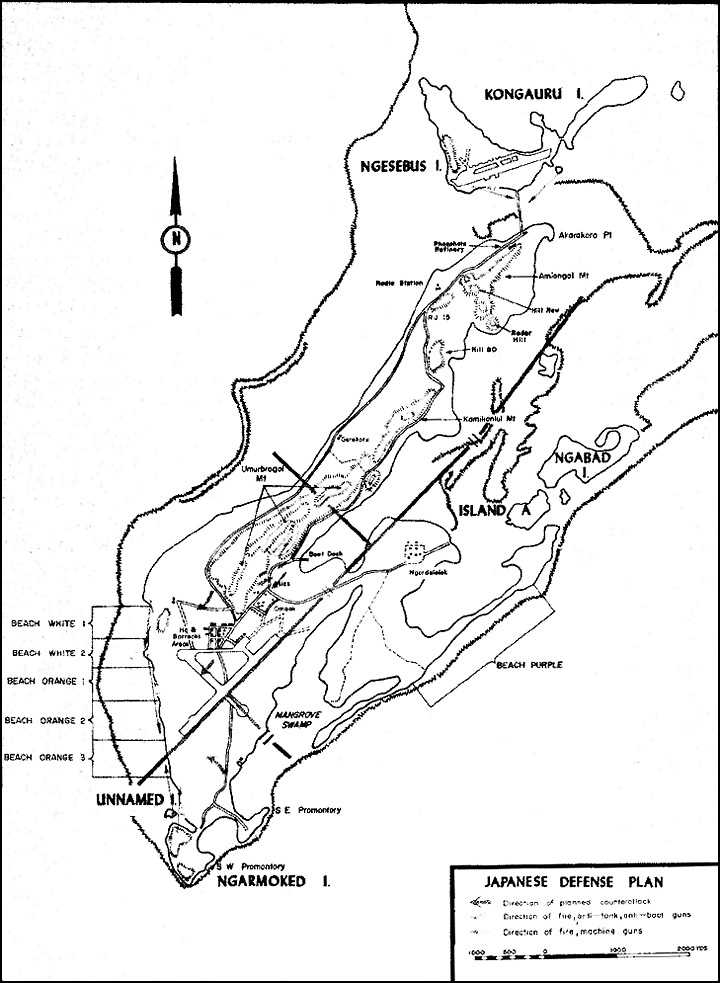
Map 3: Japanese Defense Plan
The Umurbrogol ridges were, of course, the key to a successful defense of Peleliu, and the Japanese made the utmost use of its rugged terrain. They developed the natural caves that existed practically everywhere or blasted others into the almost perpendicular cliffs in order to deploy their troops and locate their weapons for a last-ditch stand. If driven from prepared positions, enemy soldiers could take refuge in the abundant natural cavities in the ridges, and by sniping from and defending every cave, crack, or crevice large enough for a man to squeeze into, could tenaciously prolong the resistance.
Due to bitter inter-service rivalry, both the Army and the Navy independently developed their own caves. The Navy, with the help of the 214th Naval Construction Battalion and a tunnel construction unit, was able to build some rather elaborate underground installations. These were located mainly in the north of Peleliu and consisted for the most part of tunnels, ranging from single ones up to networks of 10 or more. The hollowed-out chambers usually measured 10 feet across and 6 feet high, often with separate rooms for food and ammunition storage, living quarters, and medical facilities. Some even had the benefits of electric lights, ventilation systems, and wooden floors. Designed primarily as shelters against air and naval bombardment, these underground positions had no prepared defenses against the onslaughts of attacking infantry/tank teams.
The Army’s caves, on the other hand, while not so large, elaborate, nor ingeniously constructed as those of the Navy, were built and prepared for prolonged land combat. Whenever practicable, two or more staggered levels were constructed, and the multiple entrances led to tortuous passageways within a single huge tunnel system, where any number of safe refuges would protect the occupants from the concussive effect of bombing and shelling and provide cover from direct fire. Every effort, of course, was taken to camouflage skillfully all cave openings, while still preserving protection and clear fields of fire. Siege defense preparations consisted of jamming every nook and crevice with food and ammunition and building troughs to collect the water dripping from overhead stalactites.
Tactical reasons alone determined the location of the Army’s caves. Fortifications were built, weapons sited, and soldiers deployed in order to provide a mutually interlocking system of concrete pillboxes, entrenchments, gun emplacements, and riflemen’s positions dominating the strategic areas. Near every important artillery or mortar emplacement were other underground dwellings housing automatic weapons to provide protective fire. Communication trenches or tunnels connected these mutually supporting locations, while observation posts often were placed on top of the ridge in a natural limestone cavity or crevice. The approaches to vital installations, such as command posts, were covered from all angles by fire from cleverly located caves half way up the surrounding ridges. At most strategic points and in the final defensive area were numerous smaller underground positions designed to provide interlocking support fire from small arms. These were intended to be held
to the death, and no escape routes had been provided for their occupants.
With their final defensive positions prepared, the Japanese garrison on Peleliu could view the future only gloomily. After July, when the Palaus were written off by the Imperial high command, whose attention was centered on the approaching decisive battle in the Philippines, even the receipt of the more essential supplies dwindled to a mere trickle due to shipping losses by attacks from American submarines and aircraft. The future prospects seemed dim indeed.
The Americans had the choice of either assaulting the islands or bypassing them, thereby allowing the Japanese garrison to degenerate into a state of combat ineffectiveness through lack of supplies and food. If the invasion came, then the enemy soldier faced the dilemma of either surrendering or waging a bitter fight to the death. No hope of relief or reinforcements could be expected.
After communications with the Thirty-first Army’s headquarters on Saipan ceased in August, the Palau Sector Group was reassigned by IGHQ, for administrative purposes, to the Southern Army which controlled operations in the Philippines, and operationally to Headquarters, Combined Fleet. When advance intelligence indicated an imminent American assault, it was the Southern Army that notified General Inoue on 3 September as to the probable time and place of the landing. A few days later, Japanese intelligence officers estimated the size of the attacking force to be probably a division. Just before the actual invasion, the Japanese learned that the assault force commander was Major General Julian C. Smith.
General Inoue immediately notified all of the forces under his command that the long awaited opportunity to annihilate the Americans was near at hand. But as late as 8 September, Palau Sector Group Headquarters thought the carrier strikes might be just feinting actions, with the main assault coming elsewhere. When the heavy caliber shells of the American battleships began falling on 12 September, however, Inoue knew, without doubt, that the decisive moment had arrived. With great eloquence, he informed his command of the approaching battle:–
This battle may have a part in the decisive turn of tide in breaking the deadlock of the ‘Great Asiatic War.’ The entire Army and people of Japan are expecting us to win this battle. There will never be another chance as these few existing days for the people living in the empire to repay the emperor’s benevolence again. Rouse yourselves for the sake of your country! Officers and men, you will devote your life to the winning of this battle, and attaining your long cherished desire of annihilating the enemy.26