Chapter 22: The Revival of ORANGE
You don’t kill men with guns you’re not using.—GENERAL MATTHEW B. RIDGWAY
After mid-1942 and throughout most of 1943, while American naval, air, and ground forces were engaging the Japanese in desperate battle in the Solomons, in New Guinea, and in the Aleutians, relative calm reigned over the Central Pacific. In this region, stretching westward across the ocean from the Hawaiian Islands to the Philippines, Japanese fleets and merchant vessels roamed freely, subject only to the attacks of Pacific Fleet submarines, which were taking an ever-increasing toll of enemy ships. Scattered Japanese garrisons leisurely built airstrips and prepared their defenses, scarcely aware of the war that raged to the north and south. But even while these battles were being fought, plans were being laid at Pearl Harbor and in Washington for an offensive that would ultimately reach the coast of Japan itself. Before the year 1943 was out the Central Pacific would see some of the bitterest fighting of the war.
The Central Pacific War
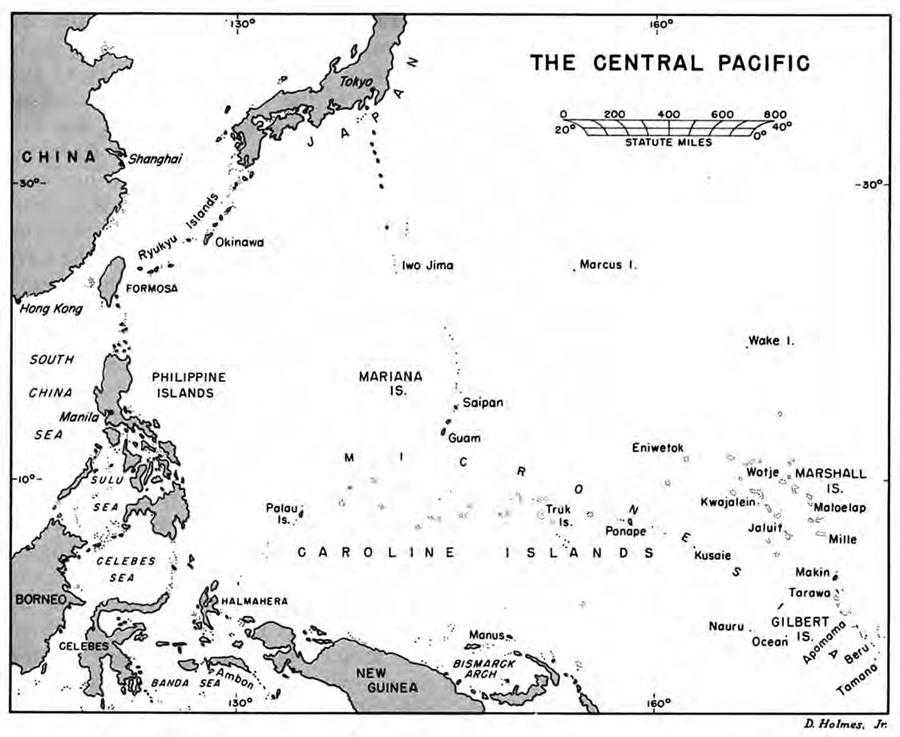
The scene of impending conflict was Micronesia, an ocean area larger than the continental United States. Scattered throughout this vast expanse of ocean are tiny islands, numbering over 1,000 and clustered into four major groups whose total land area is about 1,200 square miles. (Map 7) Most easterly of the groups are the Gilberts, low-lying coral atolls located just west of the date line and almost on the equator. To the northwest are the Marshall Islands, a double chain of atolls, reefs, and islets, none of which rises more than a few feet above sea level. Stretching almost due west from the Marshalls, in a long irregular string about 2,000 miles in length, are the 550 islands of the Caroline group. In the center of the group lies Truk and at the western extremity is Palau, pointing a finger at the Philippines. The Marianas, fourth of the island groups of Micronesia, lie above the Carolines and extend for more than 400 miles from Guam in the south to within 500 miles of Iwo Jima.1
Strategically located across the main sea lanes between the United States and the Philippines and dominating the most direct avenue of approach to the western Pacific, the islands of Micronesia played a vital role in Japanese war plans. Forehandedly, the Japanese had gained
Map 7: The Central Pacific
control of most of these islands before the war. The Carolines, Marshalls, and Marianas (except for Guam) , they had seized from Germany during World War I and held under a mandate from the League of Nations. The rest—Guam, the Gilberts, and the two phosphate islands, Ocean and Nauru—they occupied shortly after Pearl Harbor, thus extending the outer perimeter of the empire’s defenses almost to the date line and placing Japanese forces in position to cut the Allied line of communications in the South Pacific. Only the disaster at Midway kept them from pushing on to Samoa and the Fijis, as they had every intention of doing.2
Vital as the Central Pacific was to the Japanese in the defense of the home islands, it was equally important to the Americans, who recognized it as a separate area of responsibility under Admiral Nimitz’ direct command. Along it lay the line of communications to the Philippines and the traditional path of
advance against Japan marked out in the ORANGE plans of the 1920’s and 1930’s.3 According to these plans, the Pacific Fleet with troop-carrying transports would venture from Pearl Harbor at the start of war and sail westward into the Mandates. The advance of this force was to be a progressive, step-by-step affair in which selected islands would be seized and developed as forward bases before the next move began. Thus would the United States project its naval strength ever westward until the Philippines were reached.
In prewar plans, the Philippine garrison had been assigned the mission of holding Manila Bay for an indefinite period, presumed to be six months. Though few responsible officers believed the fleet could fight its way through to Manila Bay in that time, the ORANGE plans made no provision for any other contingency, such as the recapture of the Philippines. Thus, according to these old plans, when the fleet reached Manila Bay with its reinforcements it would find the bay in friendly hands, available as a base for further operations.
It was this plan, modified and placed in the context of a global struggle in which Germany was the main enemy and Europe the main theater, that was in effect on the morning of 7 December.4 But the Japanese attack on Pearl Harbor altered completely the balance of forces in the Pacific and rendered obsolete the ORANGE concept of a Central Pacific offensive. The Navy would have enough to do defending the Hawaiian outpost and the west coast of the United States. Guam, Wake, and the Philippines lay beyond reach and all hopes for an early offensive into the Mandates lay at the bottom of the bay with the battleships of the Pacific Fleet. Until this loss was replaced and the Pacific Fleet strengthened, the Navy would have to husband its resources and fight a defensive war.
The adoption of a defensive strategy did not mean inaction and from the start the Pacific Fleet struck at the enemy whenever and wherever it could with the meager forces available. Thus in the period from February through March 1942, task forces built around the three carriers, fortunately absent from Pearl Harbor at the time of the attack, raided Japanese-held islands in a vain effort to divert Japanese forces in their drive southward. In April came the carrier-borne strike against Tokyo and in August the premature raid on Makin by the 2nd Marine Raider Battalion led by Lt. Col. Evans F. Carlson. But perhaps the most profitable operations of the fleet during this period were those of the submarines, which in the first four months of the war sank 300,000 tons of Japanese shipping.5
Spectacular as these miscellaneous operations and hit-and-run raids were, they did not end the Japanese threat to Hawaii or ensure the security of the line of communications across the South Pacific. It was the victory at Midway that accomplished the first and opened
the way for an offensive designed to achieve the second. That offensive opened with the landing of the marines on Guadalcanal in August 1942 and with the first encounters between Allied and Japanese troops on the heights overlooking Port Moresby. Both campaigns proved more difficult and costly than anticipated and consumed all the resources that could be spared for the Pacific. For four months the issue hung in the balance, but by the end of the year victory seemed assured. The time had come to plan the next move in the drive on Rabaul; perhaps there would be enough left over to open the long-delayed offensive in the Central Pacific.
The Philippines in Central Pacific Strategy
All prewar plans for war with Japan, whether alone or in concert with other powers, had been conditioned largely by the almost impossible task of defending the Philippines. It was this problem rather than the defeat of Japan that preoccupied the planners and produced the ORANGE concept for an advance across the Central Pacific and the successive capture of positions in the mandated islands. The objective of these operations, essentially naval in character, was the reinforcement of the Philippines. Japan would be defeated later by operations vaguely described in ORANGE as “military and economic pressure made progressively more severe.”6 If these did not produce the desired result, other means would be devised.
A whole generation of officers had learned their lessons in the ORANGE school. As students at the Army and Navy War Colleges and during their tours in the Pacific and in Washington they had developed theoretical exercises and solved theoretical problems on the basis of the ORANGE assumptions. Now, as senior officers in wartime, they faced the cold reality of defeating an actual enemy. It is not surprising, therefore, that their first wartime planning for an offensive in the Central Pacific should follow the familiar pattern of the time-tested, Philippine-oriented ORANGE plan.
This pattern was clearly evident at the Casablanca Conference in January 1943. There, for the first time in Allied councils, the concept of a progressive advance across the Central Pacific was resurrected and an effort made to coordinate such an advance with the offensive already under way in the South and Southwest Pacific and in the Aleutians.7 There was no thought of initiating a Central Pacific offensive immediately or substituting it for the drive on Rabaul, an objective never foreseen in prewar planning. Nor did the plans developed at Casablanca envisage operations beyond the Philippines. In this sense Pacific strategy after a year of war was still closely tied to the prewar ORANGE concept. The only difference was that the enemy had forced on the Allies a different route of advance. The objective was still the Philippines.
The spokesman for the Central Pacific at Casablanca was Admiral King. That he should speak out first was natural in view of the predominantly naval character
of the area and the traditional interest of the Navy in this route of advance. His advocacy of a Central Pacific offensive, however, did not imply any lessening of the effort in the South and Southwest Pacific. Operations there were essential, he believed, for the security of Australia and the line of communications. But once that campaign was over and Rabaul captured, where would the Allies go next, King asked. He found his answer in ORANGE, his objective in the Philippines.
In choosing the Philippines, Admiral King did not rule out offensives elsewhere, in the North Pacific and on the Asiatic mainland. Nor did he overlook the Netherlands Indies as an alternative objective to the Philippines. The Japanese had gone to war primarily to obtain the rich natural resources of the Indies and were largely dependent on these islands for the prosecution of the war. Their loss would be a crippling blow for the Japanese and any effort by the Allies to seize them would meet with determined and desperate resistance. Moreover, as Admiral King pointed out, an operation against the Japanese in the Indies would constitute, in effect, a frontal assault on a strongly held position, a costly and difficult venture in any case. The Philippines, King asserted, could be taken with far less effort and at much lower cost. And from these islands, which lay along the main Japanese line of communications, the Allies would be able to cut off the vital flow of oil and other resources to Japan as effectively as from the Indies.8
To Admiral King, the most feasible approach to the Philippines was by way of the Central Pacific. Though he did not commit himself at Casablanca to this route, he made it clear that he preferred it to the two other alternate approaches. The one in the south, he pointed out, was outflanked by enemy bases in the Mandates and unsuitable for large fleet engagements; the one to the north, starting from the Aleutians, he apparently never considered seriously. The advantages were clearly all on the side of a direct thrust across the Pacific. It was shorter than the southern route; it would take American forces along a path familiar to most naval officers from their studies at the Naval War College; and it would approach the Philippines from the flank by way of the Marshalls, Truk, and the Marianas.
General MacArthur would not have agreed with this reasoning. Writing in retrospect ten years after the war, he explained his view toward the Central Pacific as follows:–
The so-called “Central Pacific Concept,” as finally embodied in the Orange War Plans, had in mind the relief of the Philippines before those Islands fell to the Japanese in the event of attack. This necessitated securing the lines of communication and supply between the Philippines and the United States which were threatened so long as Japan continued to hold and occupy the flanking Central Pacific Islands mandated to her following World War I. The “Central Pacific Concept” consequently lost its validity when it was abandoned in favor of a “Europe First” policy as the Japanese actually struck the Philippines. That was the time which presented the golden opportunity, both in strategy and logic, for a Central Pacific drive by our combined fleets aimed at engaging and destroying Japan’s naval power on the Pacific. Had we reacted in this manner as always theretofore intended we would have brought the war to a speedy and victorious close and saved the
Philippines and other areas on the Pacific from the long travail of enemy occupation, while at the same time sparing our own nation the terrible sacrifice exacted during the ensuing years of conflict.
Apologists for the “Europe First” concept point to our Pearl Harbor losses as having so weakened the Navy as to prevent such a Central Pacific drive. This argument has little or no validity for the diversion of the naval power engaged in the relatively unproductive North African campaign could have enabled the massing of a Combined Fleet capable of overpowering any combination of naval strength the axis powers were able to mount in the Pacific. This evaluation flows from the facts that the enemy European fleets by that time had been reduced to little more than a nuisance value, the German threat to the middle east had been eliminated by Rommel’s defeat at El Alamein, the German offensive in Russia had been stopped at Stalingrad and the great Russian ground counter-offensive had been successfully launched. Having missed this initial opportunity, the belated Central Pacific drive toward the Marianas in July 1944 could at best produce local tactical successes without bringing to bear any decisive influence upon the course of the war.9
For different reasons than MacArthur might have advanced had he attended the Casablanca Conference, the British were doubtful of the virtues of an advance across the Central Pacific to the Philippines. As a matter of fact, they were opposed in principle to any Pacific venture that might threaten the primary effort against Germany. But when Admiral King readily agreed, at least in principle, that the recapture of the Philippines should come after Germany was defeated, the British did not pursue the subject. They doubted also the advisability of scheduling preliminary operations in the Central Pacific as far as Truk before the final blow in Europe, but on this question King maintained a discreet silence.
During the next few days, while the American and British Chiefs ‘discussed other matters, their planners worked out a program for the Pacific for the year ahead. Included in the ambitious plan submitted on 17 January10 was the seizure of the Gilberts, Marshalls, and Caroline Islands, including Truk, as preparatory steps in the recapture of the Philippines. These operations were to begin after the capture of Rabaul, also scheduled for that year, but at least one of the planners—Admiral Cooke—thought the advance in the Central Pacific might open even earlier.11
To the British this plan, which included also the recapture of Burma, seemed more extensive than was warranted by the resources available for the Pacific in 1943. Once begun, they feared these operations might divert Allied strength from the main effort in Europe. They sought, therefore, to restrict Pacific operations and suggested that the Allies limit themselves in 1943 to Rabaul and Burma. Admiral King thought this restriction entirely unnecessary. The proposed drive into the Central Pacific, he declared, was not a commitment on Allied resources but a desirable course of action that would utilize whatever forces were available. It might include only action in the Marshalls during the year or it might extend as far as Truk, depending upon events that could not then be foreseen. If Rabaul was taken in May
then the drive into the Mandates might make considerable progress before the opening date of the Burma offensive in November. Certainly, King argued, it would be unwise to limit the Pacific program to Rabaul and Burma alone. Such a restriction might well have the effect of imposing on Allied troops in the Pacific an enforced idleness for a period of months and was contrary to the Allied aim of keeping the Japanese under “continual pressure.”
The British actually had little choice but to accept the American assurance that the Central Pacific would not drain off resources intended for Europe. Whether they actually believed this is doubtful; they were fully aware that operations once begun generate demands for additional resources. But to argue on this basis would raise questions about their own operations. Once this position had been reached, agreement came quickly. If all the Americans wanted was to ensure the fullest use of available forces and to be ready to exploit any opportunity that arose, the British were willing to accept General Marshall’s suggestion that the matter be settled by specifying that if any operations were launched in the Central Pacific in 1943 they would be made “with the resources available in the theater.”12 This qualification, taken with the proviso that such operations would not be undertaken until Rabaul had been reduced or at the expense of the Burma campaign, gave adequate assurance that operations in the Pacific would not jeopardize the Allied effort in Europe.
With agreement on the broad outline of Pacific strategy, the Americans at Casablanca were free to consider in more detail Pacific prospects for the coming year. So far as the Central Pacific was concerned, the outlook was bright. Japan, it was true, might launch an offensive of its own from bases in the Mandates, either by way of Midway against Hawaii or by way of New Caledonia, Fiji, and Samoa against the vital line of communications to Australia. The first the Japanese had already attempted, without success, and the Joint Chiefs thought another attempt would also fail. The second line of action, a drive toward the line of communications, had been partially forestalled by the Allied invasion of the Solomons, but there still remained the possibility, the Joint Chiefs believed, of a Japanese attack against Samoa from the Gilbert and Ellice Islands. Such a move, if successful, would expose the Fijis to direct invasion and cut the South Pacific line as effectively as the earlier Japanese drive southward through the Solomons had threatened to do.
To counter these potential Japanese moves in the Central Pacific, the Americans considered two possible courses: an advance westward from Midway by way of Wake and the Marshalls to the Truk-Guam line; or northwest from Samoa through the Ellice and Gilbert Islands into the Marshalls. Both would serve the purpose of forestalling an enemy attack, would keep the Japanese off balance, and divert their forces away from Rabaul, where the Allies expected to make their major effort. In addition, the second course would ensure the security of the Fiji-Samoa portion of the line of communication. If this course was
adopted, it would be possible to advance to the Truk-Guam line by way of Rabaul once that bastion was reduced, either in concert with a drive from the east or alone.13
These were the courses open in January 1943, but it was still too early to make a choice that might prove unnecessarily restrictive at a later date. The decision of the Joint Chiefs, therefore, was one calculated to leave them free to seize any opportunity that might arise. It called for an advance west from Midway “as practicable,” northwest from Samoa, and north from Rabaul—the last to be undertaken only if there were sufficient forces at hand to occupy and exploit the Truk-Guam line. The British, it will be recalled, accepted this statement of U.S. intentions without comment and on 23 January it was adopted as part of the final report of the conference.14
With the sanction of the Casablanca decision, Admiral King set his staff to work in February 1943 on plans for an early assault against the Ellice and Gilbert Islands, followed, perhaps, by the seizure of the Marshalls.15 Undoubtedly influenced by the delay in getting Task Two of the Rabaul offensive under way, he wanted now to take up the slack in Pacific operations with an offensive in the Central Pacific. In this way, he thought, the Allies would be able to retain the initiative while, at the same time, diverting Japanese forces from the defense of Rabaul.
Before presenting this proposal to his colleagues on the Joint Chiefs of Staff, Admiral King sounded his chief naval subordinates in the Pacific, Admirals Nimitz and Halsey. The response was anything but encouraging.16 Admiral Halsey, who was then preparing for further operations in the Solomons, thought he had enough to do without taking on another job. Far from supporting his operations in the South Pacific, this new task would drain away forces from the central effort and make Task Two more difficult and time-consuming. All the forces available should be thrown into the Solomons, he told King, for the Japanese were consolidating their positions there and delay might well prove costly. In this view he was strongly supported by his superior, Admiral Nimitz, who felt that until the Americans gained a marked superiority over the Japanese in naval and air strength, it would not be advisable to strike out in the Central Pacific.
Admiral King was not convinced by these arguments and thought his two most experienced commanders, each preoccupied with his own problems, had missed the point. An offensive in the Central Pacific, conducted simultaneously with the offensive in the South,
would, he believed, support that effort and at the same time draw strength from it. What he had in mind, he explained, was to “whipsaw” the Japanese to prevent them from concentrating their forces in one area.17
But Halsey persisted in his opposition to the scheme. While recognizing the advantages of mutually supporting operations in two separate areas, he thought an attack such as King was proposing would be both unprofitable and costly. It would constitute a frontal assault, and, even if successful, would gain for the Allies no important objective. On the other hand, the islands, once seized, would prove a continuing drain on Allied resources and virtually require further advances in the same direction, which may have been precisely what Admiral King wanted. To Halsey, Rabaul was the prime objective, the key to the Japanese defenses, and he was all for striking at it as soon as possible and with everything he had and could get.18
At this stage, General MacArthur indicated his readiness to discuss plans for the capture of Rabaul, and the planners, meeting with Nimitz’ and Halsey’s representatives in Washington at the Pacific Military Conference, devoted almost the entire month of March to this problem.19 But even during this period Admiral King did not abandon altogether his hopes for an early drive against the Ellice and Gilbert Islands. At one point in the conference, when General Sutherland, MacArthur’s chief of staff, presented the plan agreed upon by the theater representatives, King again raised the possibility of an offensive in the Central Pacific.20 The plan proposed, he pointed out, would immobilize naval forces in the South Pacific for some time and he suggested that they be used during this interval in the Central Pacific, specifically in the Gilberts and Marshalls. Why he preferred the Marshalls to the Ellice Islands, he did not say.
Again the main opposition came from naval officers in the Pacific. Vice Adm. Raymond A. Spruance, Nimitz’ representative at the conference, agreed that naval forces could not be allowed to remain idle while MacArthur advanced up the New Guinea coast to New Britain, but he did not believe the time was yet ripe for an attack against the Gilberts and Marshalls. It would be necessary, first, to seize advance positions from which to support such an attack; and, second, to assemble a large enough force to continue the advance across the Central Pacific after the islands were captured. Like Halsey, he did not think the Gilberts and Marshalls a sufficiently important objective to warrant attack unless it was followed up. So far as the fleet was concerned, Spruance thought it might best be employed, if not needed in the South Pacific, in the Aleutians and in the Hawaiian area.
Captain Browning, Halsey’s chief of staff and the officer most directly concerned, was not even willing to grant that the naval forces of the South Pacific, even if temporarily idle, should be transferred to another area. The South Pacific, he pointed out, was the decisive
theater of operations for the Japanese and Halsey’s warships constituted the greatest menace to their lines of communication southward from Rabaul. So long as the Allies maintained a naval striking force there, the Japanese would be forced, Browning asserted, to keep a strong naval force of their own in the vicinity. Thus, the mere existence of a South Pacific fleet would, in a measure, ensure the security of Hawaii. It should therefore remain where it was, Browning concluded, unless its employment elsewhere would contribute to the main offensive mission of the theater, the capture of Rabaul.
At this point in the conference Admiral King dropped the subject. With his two top commanders in the Pacific and their representatives in Washington—all senior naval officers—arrayed in opposition to his plan, King must have realized that he had no chance of success. Clearly the weight of opinion was against him. The Central Pacific offensive would have to await the capture of Rabaul, postponed by the Pacific Military Conference to 1944, or an increase in the forces available and projected for the Pacific.
By his decision to abandon temporarily the proposal for a Central Pacific offensive, Admiral King unknowingly avoided a head-on conflict with General MacArthur over basic strategy. For MacArthur, too, had a plan, appropriately called RENO, for divorcing the Japanese from their Philippine prize but by a route altogether different from that favored by King.21 And in view of MacArthur’s strong ties in the Philippines and his dramatic promise in March 1942 to return, it was unlikely he would agree to any plan that did not permit him to keep his pledge. In his eyes, the liberation of the Philippines was a personal as well as a national obligation. He would not yield the privilege of fulfilling that obligation to any other.
But MacArthur did not base his RENO plan on these political and personal grounds—valid as they may have been. He had sound military reasons for the course he advocated. The Philippine Islands, he contended, were the most important strategic objective in his theater, promising results far more decisive than any that could be achieved by the capture of Rabaul. This importance the islands derived from their position athwart the major sea routes linking Japan with the vital oil and raw materials to the south. Control of the islands, therefore, would enable him to sever “the main artery of supply to Japan’s factories” and so reduce her capacity to wage war as to make her vulnerable to direct assault. Thus far, he and King were in agreement.
It was on the choice of routes to the objective that they parted company. To MacArthur looking northward from Australia there seemed to be four possible approaches to the Philippines:–
1. Westward from Hawaii through the Central Pacific by way of the Marshalls and Carolines.
2. Northwest from Australia along the north coast of New Guinea to Halmahera and then to Mindanao.
3. Due north through the Netherlands Indies by way of the Banda Sea and Molucca Passage.
4. Westward from Australia to Macassar Strait or the South China Sea, then north.
Of these four routes, MacArthur favored the second. For him it was the shortest, and the one that most effectively utilized the power of land-based aircraft, exploited the enemy’s principal weakness, and took full advantage of the positions won in the advance on Rabaul. The danger of attack from the flanks to which his forces would be exposed when they reached the tip of New Guinea could be obviated, MacArthur believed, by the neutralization or occupation of Palau to the north by Nimitz’ forces and of Ambon in the Netherlands Indies by his own forces. One great advantage of this route that MacArthur stressed was the fact that it led directly to Mindanao, where there were excellent airfield sites and where Allied operations would be supported by a strong guerrilla force and by heavy and medium bombers based on northwest Australia and New Guinea. The advance to Luzon, the ultimate objective, would follow the occupation of Mindanao.
In MacArthur’s opinion none of the other routes offered comparable advantages. Both routes through the Indies (Nos. 3 and 4) would meet major Japanese ground forces, would be exposed to flanking attacks, and would fail to utilize the full strength of Allied forces. The Central Pacific route (No. 1) so strongly favored by Admiral King,, was subject to even more serious criticism, MacArthur thought. It was the longest of the four routes, would require large naval forces, and would have to be made without the support of land-based air power. But perhaps the most telling argument against the Central Pacific route was the fact that an offensive westward from Hawaii would require “a re-orientation of front” in the Pacific. There was little doubt that in his view such a change would represent a basic shift in strategy and vitally affect his own plans for recapturing the Philippines.
With these convictions, it was certain that MacArthur would oppose the concept of a Central Pacific offensive. That he did not at this time was due simply to the fact that he was not officially informed of King’s plans. Nor, for that matter, was King or any other member of the Joint Chiefs aware of RENO. At the Pacific Military Conference General Sutherland had presented only the ELKTON plan for the recapture of Rabaul; he had made no mention of RENO although he was present during King’s discussion with Spruance and Browning. So long as others were able to postpone the Central Pacific offensive, Sutherland apparently saw no need to reveal MacArthur’s plans. But the question was not yet settled and would not be until MacArthur had presented his case. That time was not far off.
The Japanese
The development by the Japanese of an integrated and mutually supporting defensive system in the Central Pacific dates from the spectacular raid on Makin by Colonel Carlson’s marines in August 1942. Heroic and daring as it was, the raid had consequences never foreseen by those who proposed it. It had been designed to confuse the enemy, divert his forces from Guadalcanal, and gain information and prisoners. All these it accomplished, but it also demonstrated to the Japanese suddenly and dramatically how weak were their defenses in the Central
Pacific. More than any other single event it alerted them to the danger of attack in an area they considered secure and because of it they committed far heavier forces there than they had originally intended. In this sense, the Makin raid proved a costly venture and made the task for those who followed much more difficult.22
Up to the time of Makin, the Japanese paid scant attention to their Central Pacific outposts. Though the Navy, which had responsibility for the area, fully appreciated the strategic value of these islands, it consistently overestimated their defensive strength and assigned to them only token garrisons. Thus, it entrusted the safety of the seaplane base at Makin to a detachment consisting of less than fifty men and commanded by a warrant officer. To its other outposts in the Gilberts, the Navy sent garrisons of comparable size, secure
in the belief that the islands were safe so long as Japanese planes and ships controlled the skies and seas of the Central Pacific.
Their illusions of safety shattered by the Makin raid, the Japanese moved with vigor and speed to overcome their earlier neglect. From Jaluit in the Marshalls, headquarters of the 6th Defense Force, came a company-sized unit, part of it flown into Makin on 20 August and the rest following by ship. It was reinforced on 15 September by a company of the newly activated Yokosuka 6th Special Landing Force, bringing the strength of the Makin garrison to 500.23
These reinforcements were only part of a general program by the Japanese to strengthen their position in the Gilberts. On 25 August they occupied Nauru and the next day Ocean Island, both to the west of the Gilbert chain. During the first week of September they took over Apamama in the central Gilberts and in the middle of the month they landed in force on Tarawa.
The promptness of the Japanese reaction can be surmised from the fact that the unit that occupied Tarawa on 15 September, the Yokosuka 6th Special Naval Landing Force, had come directly from Japan. Consisting of about 1,500 officers and men, the 6th Special Naval Landing Force took over responsibility for all of the Gilberts, sending detachments to Apamama and Makin. With two additional companies that had meanwhile reached Ocean and Nauru from the Carolines, the Japanese had almost 2,000 troops in the Gilberts at the end of September.
Though the islands had been abandoned months earlier by the Allies, they were not yet entirely clear of their former white residents. Those who remained, mostly Australians and New Zealanders, had fled to the small islets and atolls in the southern Gilberts where they could observe and report Japanese air and surface movements throughout the group.
The removal of this embryo intelligence net was the first task the Japanese
turned to once they had sufficient troops in the area. On 26 September a detachment from Tarawa landed on Beru Atoll and destroyed the radio station there, thus depriving the coast watchers of their vital link with the outside world. Next day the detachment moved on to the neighboring atoll, Tamana, where it found additional radio equipment, a radio operator, and two Allied soldiers. Raids on other atolls netted more equipment and prisoners. By 6 October the job was completed and the Japanese could report the Gilberts cleared of the enemy.
The next task the Japanese turned to was the construction of airfields and ground defenses. In October they began building air bases on Nauru and Tarawa. The strips were completed by the end of January 1943, and in late March, when adequate ground defenses and supporting installations were put in, a portion of the 22nd Air Flotilla from the Marshalls flew in to take over the air defense of the area.
If the Makin raid had alerted the Japanese to the threat of a Central Pacific offensive, the experience on Guadalcanal convinced them that their defenses in the area were still inadequate. Certainly the garrisons so recently established in the Gilberts could scarcely hope to withstand a determined assault such as the Allies had launched in the Solomons. “The Navy,” one former Japanese officer noted, “lost confidence in the ability of the local air base to maintain air superiority, and it realized that the defense of the islands was far weaker than it had expected.”24 A review of the situation in February and March led to a changed concept of operations emphasizing land defenses and coordinating air and ground operations with those of the fleet. This concept was approved on the highest levels in Tokyo and promulgated in orders issued on 25 March 1943. “The defense of strategic points,” these orders directed, “will be strengthened promptly, and in the event of an enemy attack, the first [Japanese] attack will be launched ... to destroy the enemy in close coordination with surface and air forces.” At the same time the Combined Fleet commander was instructed to keep the main body of his carrier forces in the Pacific and “to annihilate the enemy fleet with interception operations.”25
On the basis of this revised strategy, the Japanese proceeded during the spring and summer of 1943 to strengthen their position in the Gilberts and Marshalls. The naval ground forces in the Gilberts were reorganized and designated the 3rd Special Base Force, additional units and laborers were brought in, and ground and antiaircraft defenses expanded. Interception areas were marked out to provide a defense in depth, and arrangements made to bring reinforcements from Truk and Rabaul in the event of attack. The Army contributed to the defense of the area also by organizing special garrison units built around an infantry battalion and artillery battery for duty in the Central Pacific. One of these went to Wake, another to Marcus, but the one earmarked for the Gilbert Islands met disaster at sea. A fourth unit was thereupon organized to replace it,
but the need in the Solomons proved greater and it was diverted to Bougainville. The unit finally sent was a regiment of the 65th Brigade in the Philippines, but it got no further than the Marshalls, thus leaving the defense of the Gilberts in the hands of the Navy.
The Central Pacific in Long-Range Strategy
In the spring of 1943, American planning for the Central Pacific assumed a new and broader meaning in the strategy of the war against Japan. Throughout 1942, Central Pacific strategy had been narrowly conceived in terms of the prewar ORANGE plan as the route to the Philippines. But as the tide of war turned, the planners in Washington began to look further into the future in search of a strategy by which to defeat Japan. The immediate objectives—Rabaul, the Truk-Guam line, and Burma—remained the same, but the objectives beyond changed. Scrutinized in terms of a broader frame of reference than envisaged in ORANGE, the recapture of the Philippines seemed to be less urgent than it was before. Within this context, the role of the Central Pacific acquired a significance it had never had in the prewar period.
Work on a long-range plan for the defeat of Japan had begun in August 1942 but it was not until April of the following year that the Joint U.S. Strategic Committee, which had responsibility for the task, submitted its plan to the Joint Staff Planners.26 In it the committee recognized frankly and apparently for the first time that to achieve the objective of unconditional surrender set at Casablanca it might prove necessary to invade the Japanese home islands. How this would be done and what would be required, it was still too early to say. But the planners did hold out the hope that the Japanese might capitulate under other circumstances: (a) if they lost control of the sea lanes in the Far East and therefore the ability to wage war, or (b) if their centers of production were destroyed and their will to resist broken by “a sustained, systematic, and large-scale air offensive.” In any case, control of the sea and the intensive air bombardment of Japan were indispensable prerequisites to an invasion of the home islands.
To the planners of the JUSSC, the key to Pacific strategy lay in the air offensive against Japan, for the choice of an area from which to launch this offensive would largely determine the direction of the advance and the selection of objectives. Siberia, the Kurils, and Formosa were considered but the planners finally chose China as the best base for the air offensive. It met the requirements of proximity to the target, provided areas for widely dispersed airfields, could be used to mount an invasion of Japan if one proved necessary, and contained friendly forces with a potential for offensive action. As Admiral King remarked, “China’s geographical position and manpower were vital to the defeat of Japan and must be used. A collapse of China would vastly prolong
the war and vitally affect the whole situation vis-a-vis Japan.”27
The choice of China created certain problems. Airfields would have to be developed, equipment and supplies in large quantities brought in, and a large American force maintained in China. The Chinese were incapable of doing the job and the existing land and air supply lines were clearly inadequate to support so great an effort. What was needed, the planners concluded, was a port such as Hong Kong on the east coast of China. With Hong Kong in Allied hands, it would be possible to ship directly to China from the United States all the men, supplies, and equipment required to launch the air offensive and, if necessary, invade Japan. Here for the first time was a clear statement of the concept behind the China coast strategy, which became so persistent a theme in American planning for the war against Japan.
The logic of their reasoning now took the planners step by step back across the Pacific. If the capture of Hong Kong was necessary to mount the air offensive against Japan, the Allies would have to gain control of the South China Sea. The best way for American forces to reach this body of water, the planners thought, was through the Sulu Sea, lying between the Philippines and Borneo. And the Sulu Sea, in turn, was best approached by way of the Celebes Sea, a route that could have the advantage of cutting off Japan from the supplies in the Netherlands Indies.
At this point the problem became more practical. There were two routes that might be followed to reach the Celebes Sea: one by way of Pearl Harbor through the Mandates to Mindanao in the Philippines, the other by way of the Solomons and New Guinea to Halmahera. Which should they choose? After considerable deliberation the Joint Staff Planners finally decided that both routes should be followed, but the Central Pacific route, they thought, would produce more decisive results and they therefore recommended that the main effort be made there.28
In their analysis of the most favorable route to the Celebes Sea, the planners weighed carefully the relative merits of the approaches through the Central and the South—Southwest Pacific Areas. The first, they thought, was more desirable for a variety of reasons. It was shorter and more direct, and therefore would be logistically more economical. Also, the Allies would encounter fewer problems in maintaining troops and developing air bases on the islands and coral atolls of the Central Pacific than in the damp, malaria-infested jungles of New Guinea and the Solomons.
But more important than these were the strategic advantages of the Central Pacific. There the Allies would be able to strike the Japanese on their vulnerable eastern flank, at points where the Japanese could bring to bear only such limited air and ground forces as they
could base on the small and widely separated islands in that region. Against such forces the Allies could concentrate the full power of their rapidly growing naval and naval air strength. In amphibious operations, the Allies could expect by their concentration of power to overcome the disadvantages imposed by the great distances in the area and the limited opportunities they would have to utilize land-based aircraft. And finally, U.S. naval power in the Central Pacific, if employed successfully against the main body of the Japanese fleet, might open up the way for an attack against Japan itself.
One of the most persuasive reasons for emphasizing the Central Pacific as the planners did was the huge shipbuilding program in the United States. This construction program dated from July 1940, when Congress had passed the so-called Two-Ocean Navy Bill authorizing an expansion of about 70 percent in combat tonnage. Thus, when the Japanese attack on Pearl Harbor came, the construction of naval shipbuilding facilities required to meet the exigencies of war was already under way. Thereafter, expansion continued at an accelerated rate and by the early part of 1943 had reached full production capacity.29 Other problems remained, and the shifting tides of war created new demands and priorities but these were largely solved as they arose. By the spring of 1943, the ships whose hulls had been laid in 1940 and 1941 were reaching completion. Of the o battleships authorized in 1940, 6 were in service by the end of 1943. Carrier strength, which on 7 December 1941 consisted of 7 first-line vessels and I escort, increased in the same period to 50 carriers of all types. Most of these were escort carriers but among the new ships commissioned were 7 carriers of the Essex class as well as 9 light carriers. Warships of other types in corresponding numbers reached completion during the year 1943, including landing craft and auxiliary vessels. Of these last, perhaps the most important for amphibious operations were the attack transports and cargo vessels.30
The promise of this large fleet of carriers, battleships, cruisers, and destroyers, many already completed or close to completion in the spring of 1943, created its own pressure for a strategy that would exploit to the full this potential naval superiority. Only in the open waters of the Central Pacific could the United States employ such a fleet to its fullest extent. There it could be used as an offensive weapon to seek out and destroy the enemy fleet and to support amphibious operations that would not only bring U.S. forces closer to Japan but would also create situations that would bring the enemy’s fleet into action. No other areas in the Pacific offered similar opportunities, and if U.S. strategy failed to
seize them, then how, asked the planners, could they justify the costly naval construction program already approved.
In comparing the southern with the central route, the planners of the Joint U.S. Strategic Committee noted that an advance from the east by strong American naval and air forces in the Central Pacific would outflank Japanese positions on the north coast of New Guinea and sever Japan’s line to the Indies. On the other hand, a drive northward by MacArthur’s forces up the north coast to New Guinea, would have no effect on the Japanese in the Central Pacific whose position rested on local air and naval superiority and an unchallenged line of communications to the home islands. As a matter of fact, the planners observed, the Japanese in the Central Pacific would be able to attack MacArthur on his flank and rear as he advanced northward, an ability they would not possess if the Allies elected to make their drive from the east. Moreover, the southern route followed a longer and more circuitous course than the central route and would require the seizure of Japanese positions whose strength, unlike those in the Mandates, was limited only by the availability of troops and shipping. And in contrast to the widely separated Japanese garrisons in the Central Pacific, the Japanese in the South and Southwest Pacific had established a system of mutually supporting bases providing defense in great depth.
Though the central route was clearly preferred by the planners, they saw many reasons why the road up through the Solomons and New Guinea merited consideration. MacArthur’s forces, supported by an extensive system of bases stretching back to Australia and the islands of the South Pacific, were already engaged with the enemy. To shift them now to the Central Pacific would free large enemy forces for use elsewhere and impose a considerable strain on the logistical organization in the theater. So great would be the loss of time and the waste of shipping required to shift front in the Pacific that the planners doubted there would be any saving in the long run.
General MacArthur, though he was not consulted at this time, could have advanced additional advantages for the Southwest Pacific route. Comparing it with the Central Pacific, he wrote in 1955:–
The main distinction between the concept underlying Southwest Pacific operations and the Central Pacific Concept was that the former embodied a series of flanking movements around enemy held strong points leaving them impotent with the severance of their supply lines to the north, while the latter envisioned the reduction of enemy strong points across the Central Pacific by costly frontal assaults. The relativity in the casualty rate historically speaks for itself.
Under our strategic conception in the Southwest Pacific we sought as we advanced north to maintain land based air support for our operations—the drive across the Central Pacific was, on the other hand, dependent upon support from carrier based aircraft. The limited potential of carrier bases due to noncontinuous operations, occasioned by the necessity for periodic return to land bases for resupply and maintenance, was demonstrated when for the first and only time the Southwest Pacific command departed from the principle against out-distancing its land based air support in the attack upon Leyte. Then we placed our dependence for air support upon carriers whose limitations threatened to a dangerous degree the success of the operations.31
Though MacArthur did not refer to them, political considerations also argued against abandonment of the southern route. Australia and New Zealand could not be expected to look with favor on any strategy that relegated them to a secondary role in an area where they had a primary interest. Undoubtedly they would feel that they had been abandoned by their American allies after bearing the brunt of the enemy’s attack during the dark days of 1942. Such an attitude might well cancel out the military advantages of a greater effort in the Central Pacific. Nor could the planners ignore the great potential oil reserves on the Vogelkop Peninsula, the birdlike head of the monster-shaped island of New Guinea. In any advance from the south these could be expected ultimately to fall into Allied hands.32
It was for these reasons that the planners, while emphasizing the decisive advantages of the Central Pacific route, recommended that the southern route also be used. They did not fail to note, moreover, that a simultaneous advance toward the Sulu Sea along both routes would give the Allies important advantages. The two forces, as they converged on the objective, would be able to support each other by air and naval operations. Each would keep the enemy in its area pinned down, uncertain where the next blow would fall and unable to shift his forces. By timing their blows skillfully and selecting their objectives carefully, the Allies could neutralize the advantages the Japanese possessed in their interior lines of communication while exploiting fully their own advantages. Strategically off balance, the Japanese would have to guard every point in their vast perimeter, from the Aleutians to the Indies. The Allies, under no such compulsion, would be free to move their forces freely and to concentrate at the point of attack.
On the basis of this reasoning, the Joint U.S. Strategic Committee envisaged the defeat of Japan in a series of operations divided into five broad phases. Assuming the cooperation of the British and Chinese, Allied forces in Southeast Asia would recapture Burma and the Burma Road during the first phase. In the Pacific, operations during this phase would be directed toward opening the line of communications to the Celebes Sea. These were to be exclusively American operations utilizing both MacArthur’s and Nimitz’ forces, but making the main effort in the Central Pacific. In the second phase, U.S. forces would recapture the Philippines while British forces in Southeast Asia sought to wrest control of Indochina from the Japanese. The capture of Hong Kong was to be accomplished by Chinese forces in the third phase, after the British and Americans had gained control of the South China Sea. Thereafter, the three nations would seize such airfields in China as would be required in the final air offensive against Japan (Phase IV), with China taking the major role in ground operations. The bombing of Japan (Phase V) would be primarily an American effort, but no provision was made in this general scheme to follow up the air bombardment with the invasion of the enemy’s home islands. Though the planners recognized that to secure Japan’s surrender it might prove necessary to
invade, that decision had yet to be made.
The discussions that followed the submission of this ambitious and long-range plan in April produced no significant change in the fundamental strategy outlined in the plan. The Joint War Plans Committee, which succeeded the Joint U.S. Strategic Committee as the working group of the Joint Staff Planners, was the first to review the plan. In general, the committee accepted both the reasoning and conclusions of the JUSSC, and its own plan, submitted on 5 May, was largely based on the earlier one. The war planners, however, placed less emphasis on the air offensive against Japan than had their predecessors and more on control of the seas as a means of securing the unconditional surrender of Japan.33 In addition, they added to the earlier plan a sixth phase providing for the invasion of Japan and gave to U.S. forces the primary role in this last operation. The idea of a simultaneous offensive in the Central and in the South-Southwest Pacific, with the major effort in the former area, the war planners accepted without question. Three days later, the Joint Chiefs of Staff approved this plan with minor modification.34
At the same time that they submitted their strategic plan for the defeat of Japan, the joint war planners recommended specific objectives that should be taken in 1943–1944 to achieve the long-range aims set forth in the strategic plan.35 For the Pacific, these objectives would include the completion in 1943 of Task Two (CARTWHEEL) by MacArthur’s forces, followed the next year by the capture of the Bismarck Archipelago and Manus Island in the Admiralties. The only operation the war planners scheduled for the Central Pacific during this same period was the capture of the Marshall Islands.
Limited resources in the Pacific dictated the strategy behind this program. At the Pacific Military Conference in March 1943, it had been agreed that MacArthur could not take Rabaul that year with the forces available and projected. The war planners therefore limited his future tasks to what they estimated he could accomplish with these resources. Their selection of objectives was clearly designed to place MacArthur in position to project his air and naval power into the Central Pacific to support the advance there. Thus, the reduction of Rabaul would give him air supremacy in the New Ireland—Admiralties area; the occupation of Manus, airfields and a naval base within striking range of the western Carolines. Operations in the Central Pacific, the planners pointed out, were dependent upon resources already committed elsewhere. These, they estimated, would not be available until April 1944 and the Central Pacific offensive would therefore have to be delayed until that date. Thus, though they had established the strategical primacy of the Central Pacific, the planners were forced by practical considerations to recommend that the main effort during the remainder of 1943 and during the early part of 1944 be made in the South-Southwest Pacific.
Before this proposed plan reached the Joint Chiefs, a broader program dealing with operations throughout the world
was approved.36 Prepared by a different team of planners from the Joint War Plans Committee, this study called for a more ambitious program in the Pacific during 1943 and 1944 than was envisaged in the first study. To MacArthur was assigned the task of capturing Japanese-held New Guinea, as well as the Solomons and the Bismarck Archipelago. And during the same period, according to this plan, Admiral Nimitz’ forces in the Central Pacific would go on to take the Caroline Islands after they occupied the Marshalls. Additional objectives in the war against Japan included the Aleutians, Burma, and the bombardment of Japan from bases in China.
On the basis of this world-wide study, the Joint War Plans Committee reviewed its own schedule of operations for the Pacific and on 12 May 1943 submitted a revised and more detailed plan.37 MacArthur, the war planners now estimated, would not be able to complete operations in the Bismarck Archipelago before 1 April 1944. He could then proceed to the Celebes Sea by way of the north coast of New Guinea, or up from Darwin by way of Timor, Ceram, and the island of Celebes, a route that was not seriously considered.
Operations in the Central Pacific would begin, under this, new plan, with the occupation of the Marshalls on a date the planners purposely left open. This job, they estimated, would require six months and would be followed by the invasion of the Caroline Islands—first Ponape, then Truk, and finally the western islands in the group. With a main fleet base at Truk and airfields at strategic points in the area, the forces in the Central Pacific would be in position to move west toward the Philippines and the Celebes Sea or north via the Marianas to Japan.
Carefully, the planners avoided fixing a timetable or any established order of operations. Thus far, they reminded the Joint Chiefs of Staff, it had committed itself only to CARTWHEEL, which would carry MacArthur’s forces as far as western New Britain. Thereafter the schedule was flexible and the Joint Chiefs might adopt any or all of the operations suggested. They could even cancel operations in the Bismarck Archipelago, the planners observed, if they thought the capture of Rabaul was no longer necessary and go directly into the Marshalls. In that case, the resources in the Pacific could be concentrated on the drive westward across the Central Pacific and operations in New Guinea relegated to a secondary place in line with the strategic concept of making the main effort in the Central Pacific. The decision was up to the Joint Chiefs and it would have to be made before CARTWHEEL was over. But first it would be necessary to reexamine the long-range strategic aims of the Allies and to review the decisions made at Casablanca. In recognition of this necessity, another meeting of the U.S. and British political and military chiefs had been scheduled, and already the British delegates were gathering in Washington, for the third of the wartime international conferences.