Chapter 3: ELKTON III: The Plan for CARTWHEEL
The Southwest Pacific Area
Command Structure
Most of the commands of the Southwest and South Pacific Areas which would execute the Joint Chiefs’ orders were already in existence.1 General MacArthur, as Allied Commander in Chief, had organized his General Headquarters (GHQ), Southwest Pacific Area, on U.S. Army lines. Directly under Sutherland, the Chief of Staff,2 were the four standard general staff and three special staff sections. Each section was headed by an American Army officer. Officers from the American Navy and from the Australian, Netherlands, and Netherlands Indies armed forces served in the most important staff sections, but in comparatively junior positions.3 On the surface GHQ was a U.S. Army headquarters, but its responsibilities and authority were joint and Allied in nature. It was an operational headquarters.
Under GHQ in Australia were three other tactical headquarters—Allied Land Forces, Allied Naval Forces, and Allied Air Forces, whose names indicate their functions. (Chart I) Allied Land Forces was commanded by an Australian, General Sir Thomas Blamey, and was theoretically responsible for the tactical direction of all Allied ground troops, less certain antiaircraft units which were controlled by Allied Air Forces. Under Allied Land Forces was the U.S. Sixth Army, established in the area in February 1943 under command of Lt. Gen. Walter Krueger. Included in Sixth Army were Lt. Gen. Robert L. Eichelberger’s I Corps, the 2nd Engineer Special Brigade, and the 503rd Parachute Infantry Regiment. The 1st Marine Division was under Krueger’s operational control.4 The First and Second Australian Armies, many of whose units were still in training, were part of Allied Land Forces. The main tactical headquarters which operated under Blamey
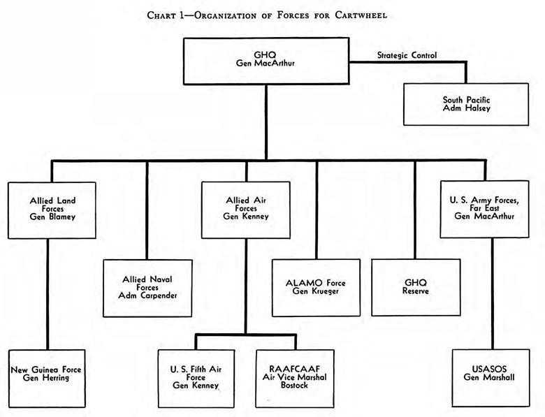
Organization of Forces for CARTWHEEL
during early 1943 was New Guinea Force, a largely Australian headquarters responsible for the conduct of operations in New Guinea. GHQ usually established a temporary advanced echelon at Port Moresby, New Guinea, shortly before the beginning of each operation.
Allied Naval Forces was commanded by Vice Adm. Arthur S. Carpender (inevitably called “Chips”) of the U.S. Navy, and included the U.S. Seventh Fleet (concurrently commanded by Carpender) and large parts of the Australian and Netherlands Navies. The most important component of Carpender’s command was the VII Amphibious Force, organized under Rear Adm. Daniel E. Barbey in early 1943.
Lt. Gen. George C. Kenney, an American airman, led the Allied Air Forces which consisted of the U.S. Fifth Air Force and the Royal Australian Air Force Command, Allied Air Forces, under Air Vice Marshal William D. Bostock. Kenney also commanded the Fifth Air Force but for tactical purposes it was run by the Deputy Commander, Brig. Gen. Ennis C. Whitehead who led the Advanced Echelon at Port Moresby, New Guinea.5
All national forces serving under these tactical headquarters were administered and usually supplied by their own service elements. U.S. Army Forces, Far East, commanded by MacArthur, was responsible for administration of the Sixth Army, the Fifth Air Force, and U.S. Army Services of Supply, Southwest Pacific Area. This last, under Maj. Gen. Richard J. Marshall, had the responsibility for logistical support of American ground forces.6 Australian Line of Communications units in Allied Land Forces supplied the Australian troops. Soldiers fighting in New Guinea under New Guinea Force were supplied by a U.S.-Australian organization known as the Combined Operational Service Command which had been created during the Papuan campaign.
Most echelons subordinate to GHQ had functioned during the Papuan campaign and by mid-1943 were operating with an efficiency born of this experience.
Geography
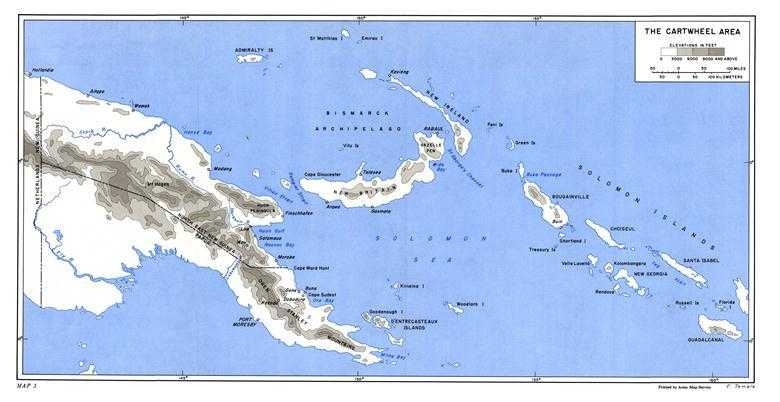
The forthcoming campaigns would be fought in New Guinea, the Solomon Islands, and the Bismarck Archipelago. Many places in these islands bear the names of outstanding figures in the history of exploration: Torres Strait, Dampier Strait, Bougainville, and D’Entrecasteaux Islands. Other names like New Britain and New Ireland are of more pedestrian origin, and the Bismarck and Solomon Seas were named during World War II.7 Despite the familiarity of many place names, the area was one of the least known and least developed in all the world. Further, although there is perhaps no ideal place to fight a war, the New Guinea–Bismarcks–Solomons
Map 3: The CARTWHEEL Area
area was one of the worst possible places. (Map 3)
All the islands have much in common, and much that is common is unpleasant. All have hot, wet, tropical climates. All are mountainous. All are heavily jungled. All are pest-ridden and full of tropical diseases, especially malaria. None has motor roads longer than a few miles. There are almost no ports with piers and quays to accommodate large ships.
The native inhabitants are Melanesians, most of them barely beyond the Stone Age. Cannibalism and headhunting were suppressed only recently in areas where British, German, Dutch, and Australian governments exerted their authority. During World War II there were rumors that some of the New Guinea natives, freed by the Japanese conquests from the white man’s restraining influence, had reverted to their ancient practices.
New Guinea, the largest island in the area and after Greenland the largest island in the world, is about 1,600 statute miles long, 500 miles from north to south at its widest point, and has an area estimated at about 312,000 square miles. Its most distinctive geographic feature, aside from the jungle, is the great cordillera that runs the length of the island. This cordillera consists of a number of parallel east-west mountain ranges which narrow into the Owen Stanley Range in the Papuan peninsula. The highest peaks reach over sixteen thousand feet into the sky. The mountain valleys that are cut by such rivers as the Sepik, Ramu, Markham, and Bulolo are several thousand feet above sea level, and the climate is pleasant and relatively healthful. There are no really large rivers in New Guinea, but the Markham, which flows into Huon Gulf, and the Sepik and Ramu are several hundred miles long. The 600 mile Sepik, flowing between the Victor Emmanuel Range and the Torricelli Mountains, is navigable by steam launch for 300 miles above its mouth. Between the mountains and the sea are swampy lowlands and vast stretches of tropical rain forest so thick that the sun never penetrates the treetops to dry the ground and no underbrush ever grows.
At the outset of the war there were no motor roads of any significant length. There were short roads in and around the main ports and gold fields and innumerable native footpaths, or “tracks.” As both Allied and Japanese forces had demonstrated during the Papuan campaign, overland travel was fantastically difficult. The best ways to travel were by water and by air. However, both the Australians and Japanese were, in the first part of 1943, engaged in ambitious transmontane road-building projects.
Before the war the Australians had exploited air travel to the utmost in developing the gold fields of the Bulolo Valley in the mountains southwest of Salamaua. They had avoided the difficulties of overland travel by cutting airstrips in the flatlands of the valley, then flying in gold-mining machinery, building materials, and, to add to the amenities of life in the attractive uplands, even race horses.
Across Vitiaz and Dampier Straits from New Guinea’s Huon Peninsula lies Cape Gloucester, the western tip of New Britain, which curves northeasterly to culminate in Gazelle Peninsula
and Rabaul. New Ireland, long and narrow, parallels the long axis of the Papuan peninsula so that it, the Admiralty Islands, part of New Guinea, and New Britain enclose the Bismarck Sea. New Britain, New Ireland, the Admiralties, and other islands form the Bismarck Archipelago.
Southeast of Rabaul, and northeast of the Papuan peninsula and the Louisiade Archipelago, lie the Solomon Islands. This 600-mile-long double-chained archipelago was found by Mendaña in 1568, but his calculations of longitude were so far wrong that two hundred years went by before white men found it again. Carteret, Bougainville, Surville, Shortland, and D’Entrecasteaux sighted or visited the archipelago between 1767 and 1793, and French geographers eventually concluded that these were the islands Mendaña had found.
The area was divided politically. That part of New Guinea west of longitude 141° east belonged to the Netherlands. Papua was an Australian possession with the status of Territory. Northeast New Guinea, the Admiralties, New Britain, New Ireland, Bougainville, and Buka made up the Australian Mandated Territory of New Guinea; Australia took them from Germany in World War I and was awarded a League of Nations mandate over them.8 The Solomons southeast of Bougainville are, politically, the British Solomon Islands Protectorate, established by Great Britain in 1893 to suppress blackbirding.
A crude comparison may give a general idea of the size of the area. If a map of the New Guinea–Bismarck Archipelago–Solomon Islands area is superimposed on a map of the United States, with the western tip of New Guinea’s Vogelkop Peninsula at Seattle, Washington, Milne Bay at southeastern New Guinea lies in Colorado, and the Solomon Islands lie in the Missouri and Mississippi Valleys.
Coastwatching
In early 1943 the key points of this huge area, except for Port Moresby, Milne Bay, Goodenough Island in the D’Entrecasteaux group, and the Guadalcanal–Russells–Florida area of the Solomons were in Japanese hands, but Allied intelligence agencies were able to keep a fairly close check on enemy troop, ship, and plane movements by means of radioed reports from observers operating behind the enemy lines. These observers were the coastwatchers, members of an organization, the Coastwatching Service, established before the war as part of the Directorate of Intelligence, Royal Australian Navy. Their territory originally embraced New Guinea, the Bismarck Archipelago, and the Solomons, but later islands of the Netherlands Indies were added to the network. Initially the coastwatchers were all British, Australian, or New Zealand civil servants or planters, commissioned in the Australian armed forces, but as the war progressed qualified men from the American forces were also assigned. The coastwatchers were part of the Allied Intelligence Bureau of the G-2 Section of GHQ. Those in the Solomons
reported their observations directly to South Pacific agencies.9
These intrepid men were greatly aided in their work by the devotion and help of the natives. The Melanesians in general remained loyal to the Allied cause, and throughout the war rescued shot-down airmen and stranded sailors, worked as guides, bearers, and laborers, and a select few stayed with the various coastwatchers.
As the interior of the New Guinea–Bismarcks–Solomons area was little known and practically unmapped, the coastwatchers proved an invaluable source of information on terrain. In addition, their hideouts served as bases for the patrols that thrust behind the Japanese lines in advance of nearly every Allied operation.
The Plan of Maneuver
On receiving the instructions from the Joint Chiefs of Staff, General MacArthur and his subordinates turned to the job of preparing plans and issuing orders to carry out the directive of 28 March. The task was not difficult. All that was needed was a revamping of the two previous ELKTON plans.
MacArthur’s headquarters issued its plan for South and Southwest Pacific Area operations for 1943 on 26 April, and followed it the next month with warning orders and operations instructions. The warning orders covered the whole ELKTON plan; the operations instructions dealt specifically with the opening phases. The 26 April plan, designated ELKTON III, was issued after a personal conference in Brisbane between Admiral Halsey and General MacArthur.
This was the first meeting of the well-known admiral and the even more famous general. Halsey was deeply impressed by MacArthur; speaking of their wartime conferences, he wrote:
I have seldom seen a man who makes a quicker, stronger, more favorable impression. ... On the few occasions when I disagreed with him, I told him so, and we discussed the issue until one of us changed his mind. My mental picture poses him against the background of these discussions; he is pacing his office, almost wearing a groove between his large, bare desk and the portrait of George Washington that faced it; his corncob pipe is in his hand (I rarely saw him smoke it), and he is making his points in a diction I have never heard surpassed.10
At this meeting, timing and coordination of the advance in New Guinea with the invasion of New Georgia were discussed.11 Halsey carried some of his points with MacArthur; they agreed that the initial invasion of New Georgia would take place at the same time as the seizure of Woodlark and Kiriwina instead of after the establishment of Southwest Pacific forces on the Huon Peninsula, as the Southwest Pacific leaders had been advocating. ELKTON III specified that the New Georgia and Woodlark–Kiriwina operations would
be simultaneous, but that major forces were not to be committed.12
The CARTWHEEL Operations
The plan of maneuver decided on by MacArthur was the same as that set forth in previous plans—mutually supporting advances along two axes, converging finally on Rabaul. The general concept underlying these operations characterized most Allied operations in both South and Southwest Pacific Areas. Despite its stiff brand of English, the warning instruction that expressed this concept is worth noting:–
The general scheme of maneuver is to advance our bomber line towards Rabaul; first by improvement of presently occupied forward bases; secondly, by the occupation and implementation of air bases which can be secured without committing large forces; and then, by the seizure and implementation of successive hostile airdromes.
By destructive air attack soften up and gain air superiority over each attack objective along the two axes of advance. Neutralize with appropriate aviation supporting hostile air bases and destroy hostile naval forces and shipping within range. Prevent reinforcement or supply of objectives under attack. Move land forces forward, covered by air and naval forces, to seize and consolidate each successive objective. Displace aviation forward onto captured airdromes. Repeat this process to successive objectives, neutralizing by air action, or by air, land, and sea action, intermediate hostile installations which are not objectives of immediate attack. The entire movement will be covered by air attack on Japanese air and sea bases along the general perimeter BUKA–RABAUL–KAVIENG–WEWAK, with the object of denying supply and reinforcement of objectives under attack.13
The operations planned for ELKTON III were lumped under the code name CARTWHEEL, and were arranged according to a complicated but flexible schedule that provided for about thirteen invasions or captures in eight months, and also provided for maximum mutual support by South and Southwest Pacific Areas.
CARTWHEEL would start with amphibious movements by the Southwest Pacific into Woodlark and Kiriwina. Simultaneously the South Pacific, using “diversionary” and “aggressive” infiltration, would move into New Georgia “and/or” Santa Isabel without committing major forces to action.14
Woodlark and Kiriwina were not held by either belligerent. Kiriwina is 270 nautical miles from Rabaul, and southern Bougainville is 300 miles away. Thus Allied fighters and medium bombers would be brought within range of these enemy areas, and Allied control over the Solomon and Bismarck Seas would be intensified. During the seizure of Woodlark and Kiriwina (designated Operation I in ELKTON III), heavy bombers would strike southern Bougainville, Buka, and Rabaul. The South Pacific would support the move by its ground operations in the Solomons (Operation A) in addition to providing strategic naval support and pinning down Japanese aircraft in the Solomons. In
accordance with Halsey’s original suggestion, the South Pacific would furnish the occupation force and an air squadron for Woodlark. The timetable included in ELKTON III allotted two months for Operations I and A. (Chart 2)
When Operation A ended, South Pacific forces would not undertake any large-scale movements, but would continue air and sea operations to support the Southwest Pacific. This area would execute Operation II, the seizure of Lae (IIa), Salamaua and Finschhafen (IIb), and Madang (IIc). Lae was to be seized two months after the initiation of the CARTWHEEL operations, Salamaua and Finschhafen six weeks after Lae, and Madang two weeks after Salamaua. The Madang operation, including the consolidation phase, would probably require two months. During Operation II aircraft from both areas would keep striking the Japanese in the Solomons, New Ireland, New Britain, and New Guinea. Airfields at Lae and in the Markham Valley behind Lae would support the advance against Madang as well as the South Pacific’s thrust against southern Bougainville.
Five and one-half months after the start of CARTWHEEL, and one month after the move against Lae, the South Pacific would complete the seizure of New Georgia, and move forward to capture the Japanese bases at Faisi in the Shortland Islands and Buin in southern Bougainville (Operation B).15 Allied aircraft from Woodlark, Kiriwina, and the Huon Peninsula would support and cover these movements. It was expected that Operation B would require six weeks.
The next two sets of operations by the Southwest and South Pacific Areas would be practically concurrent. At the beginning of the seventh month, the South Pacific was to seize Kieta, a Japanese base on the east coast of Bougainville, and begin neutralizing the airfields on and near Buka (Operation C). In the middle of the sixth month, the Southwest Pacific would cross Vitiaz Strait to take Cape Gloucester and Arawe (Operation IIIa), then occupy Gasmata and neutralize Talasea (Operation IIIb). With the New Guinea and New Britain bases in Allied hands, Wewak could be neutralized, and the operations against western New Britain could be supported. Finally, with the execution of Operations III and C, light bombers and fighters could easily attack Rabaul and Kavieng, and the South and Southwest Pacific Areas could begin to neutralize them in advance of an amphibious assault on Rabaul. This entire set of operations, it was estimated, would last for eight months. For planning purposes, ELKTON III assumed that the CARTWHEEL operations would begin about the first of June.
The arrangements for mutual support of the two areas during these operations were more detailed and exact than those for the Guadalcanal and Papua Campaigns. ELKTON III and subsequent orders, besides specifying the time and place of the CARTWHEEL operations, also provided for direct communication between South and Southwest Pacific Areas. Starting on 15 May, daily operational
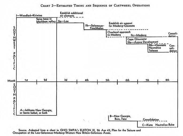
Estimated Timing and Sequence of CARTWHEEL Operations
and intelligence summaries would be exchanged. Instructions stressed particularly the necessity for a common radio frequency for fighter planes and a radio circuit connecting all major Allied air headquarters and bases. Beginning with Operations I and A, Southwest Pacific planes would conduct regular defensive reconnaissance over the Solomon and Bismarck Seas and the land areas west of longitude 155° east and southwest of the line Buka Passage–New Ireland. South Pacific aircraft would be responsible for defensive reconnaissance to the east and northeast of 155° east and the Buka Passage–New Ireland line, with a one-degree overlap granted to both areas. Offensive reconnaissance would be conducted without regard to any boundaries. MacArthur was to be notified well in advance of any movements by air or sea, and all further arrangements for coordination and mutual support would be made by him.16
Forces and Missions
MacArthur mainly used the existing headquarters in his area, but set up one new task force, primarily American, directly under GHQ. This organization, known at first as New Britain Force but from July on as ALAMO Force, was commanded by General Krueger, who retained his command of Sixth Army.17 ALAMO Force headquarters was virtually the same as Sixth Army headquarters, and placing ALAMO Force directly under GHQ had the effect of removing most American troops engaged in tactical operations from General Blamey’s control. The plans called for New Guinea Force, with General Blamey in command, also to operate directly under GHQ. Roughly speaking, New Guinea Force would conduct the operations in New Guinea while ALAMO Force ran those in Woodlark, Kiriwina, and New Britain.18 All operations would be supported and protected by Allied Air Forces and Allied Naval Forces.
Logistical responsibilities would be divided between American and Australian supply services. General Marshall’s U.S. Army Services of Supply was assigned responsibility for the immediate movement of supplies for American ground forces by water (excluding naval movements) from rear bases in Australia to the intermediate bases at Port Moresby and Milne Bay, the advanced base at Oro Bay near Buna, and other bases when established. Marshall’s command was to enlarge, stock, and operate ports and bases for the ALAMO Force, and would be responsible for completing airdromes then under construction on New Guinea and Goodenough Island. Australian Line of Communications units were to move supplies from rear bases to Cape York Peninsula, Port Moresby, and Milne Bay.
In amphibious assaults Allied Naval Forces would carry supplies forward from intermediate and advanced bases to the combat areas. When those areas were secured the regular American and Australian supply agencies would take over. In addition, Admiral Carpender’s
command would assist in the movement of supplies forward from Australia.
After some postponements caused by delays in assembling the troops for Kiriwina, D Day for Woodlark, Kiriwina, Nassau Bay in New Guinea, and New Georgia in the Solomons was set for 30 June.
The Intelligence Estimate
ELKTON III’s estimate of Japanese strength in the Bismarck Archipelago, Solomons, and New Guinea reflected the recent changes in Japanese strength and like the 28 February estimate was fairly accurate. With the Japanese in control of all sea and air routes leading from their rearward island fortresses to Rabaul, MacArthur and his staff clearly recognized that the enemy might quickly strengthen his forces. They expected that strong naval units from Truk, including 6 battleships, 2 carriers, 3 auxiliary carriers, 8 seaplane tenders, 15 cruisers, about 40 destroyers, and 27 submarines as well as about 50 merchant vessels of over 3,000 tons displacement might be made available at once. Within thirty days, about four divisions could arrive, as well as 277 airplanes and fleet units from the Netherlands Indies and the Philippines. By the end of six months, the Japanese in the Bismarck Archipelago–Solomons–New Guinea area might be able to muster ten to fifteen divisions and 755 aircraft, but not much more in the way of fleet strength.
Just as on the Allied side, the crux of the matter would be shipping. The availability of troopships would govern the size of the ground combat forces that could be sent to and maintained in the area. About 300,000 gross tons of shipping, half consisting of ships over 3,000 tons, was immediately available, and to that 100,000 to 125,000 gross tons might be added.
No mention was made of possible Japanese offensives against positions held by the Allies. Enemy capabilities were considered to be entirely defensive. The Japanese were believed able to attempt the following: defense of Lae and Salamaua while reinforcing western New Britain and north New Guinea; air attacks against the Allied communication lines as well as in tactical support of ground defenses; naval interception of Allied amphibious movements; and diversions against northwest Australia and southeastern Papua.
Specifically, it was anticipated that the Japanese would attempt to hold Lae–Salamaua while rushing about 25,000 reinforcements to Madang and Finschhafen by sea. Once the Allied offensives got under way, reasoned MacArthur’s planners, the Japanese would probably be unable to reinforce Lae or Salamaua. Enemy soldiers might be sent overland from Wewak through the Markham Valley to Lae, but would hardly be fit to fight on arrival. At the same time the Japanese could be expected to increase their garrisons at Cape Gloucester, Gasmata, and Arawe in western New Britain.
The enemy was expected to mount a maximum air effort in an attempt to defeat or delay the advancing Allies. Both daylight sorties and harassing night attacks would probably be used. If the Japanese could keep half their planes in serviceable condition, they could send out at least a hundred fighters and eighty-five bombers in the initial attacks. By
draining the Solomons, they could attack on the second day with at least twenty-four fighters and ten bombers in addition to whatever aircraft were left from the first day, and by then more planes would be arriving from outside the area. The naval surface units at Rabaul could get to Lae in not more than eighteen hours, and strong forces could steam from Truk to Lae in a few days’ time.19