Chapter 11: Tactical Planning for the Marshalls
In projecting the initial drive into the Central Pacific, it had always been understood that the first big prize would be the capture of strategic positions in the Marshall Islands. These consist of 32 island groups and 867 reefs scattered over more than 400,000 square miles of ocean. The islands lie in two roughly parallel chains about a hundred miles apart. The northeastern chain, called Ratak—meaning “sunrise”—contains the large atolls of Mille, Maloelap, and Wotje. The southwestern or “sunset” chain is called Ralik and contains Jaluit, Kwajalein, Rongelap, Bikini, and Eniwetok, as well as numerous smaller atolls. Kwajalein is located approximately in the geographic center of the group at longitude 167° 30′ east and latitude 90 north. From Pearl Harbor it is about 2,100 nautical miles in a southwesterly direction. Tarawa lies 565 miles to the southeast. Slightly south of west and about 980 miles away is Truk, which was believed to be the key bastion of the Japanese in the Carolines.
All of the islands are coral and most of them are atolls, each consisting normally of a low-lying chain of islands connected partially by reefs and surrounding a lagoon. Most of the lagoons are circular in formation and have good passages through the reefs. The largest coral atolls in the world are found in this part of the Pacific. The coral chain of some of the larger atolls extends upward of a hundred miles, encircling vast areas of water. The individual islands contained in the atolls are small, rarely more than two or three miles in length, quite narrow, and flat, never rising to more than a few feet above sea level. The larger islands are covered with coconut palms, breadfruit trees, and pandanus. The smaller ones are barren or covered only with brush.1
The first European contact with the Marshalls dates back to the period of Spanish and Portuguese explorations in the sixteenth century. The Marianas were discovered by the Spaniards in 1521, the Carolines by the Portuguese in 1527, and the Marshalls by the Spanish navigator Miguel de Saavedra in 1529. In 1686 the Marshalls were formally annexed by Spain and remained nominally attached to that nation until late in the nineteenth century. Then the German Empire began to expand its influence into the South Seas and in the 1890s commenced negotiations with Spain for transfer of her holdings in
the area. The latter’s defeat in the Spanish-American War sounded the death knell to Spain’s long-moribund empire in the Pacific. She agreed to dispose of all her possessions in the Marshalls, Carolines, and Marianas to Germany except for Guam, which was ceded to the United States. The Germans commenced a vigorous colonization policy interrupted only by the outbreak of World War I.2
In October of 1914 the Japanese Navy commenced the seizure and occupation of the main islands in this area. In December of the following year, a military headquarters was established at Truk, and the islands were divided into six administrative districts, each governed by a resident garrison commander. At the conclusion of the war all of the islands of the North Pacific formerly under German possession were turned over to Japan as a Class C mandate as provided in Article 22 of the Covenant of the League of Nations. Under the terms of the mandate, Japan was bound to prevent “the establishment of fortifications or military and naval bases,” and the neutralization of other islands in the Pacific was further guaranteed by a treaty between Japan and the United States in 1922.3 The manner in which the Japanese Empire honored these commitments will be treated later.4
Early Planning
Initial planning for the Marshalls invasion necessarily had to be conducted concurrently with that for the Gilberts operation, which would precede it, yet everyone concerned realized that final plans could not be matured until after the Gilberts had been occupied. One of the chief reasons for taking those islands was, after all, to provide bases from which the Marshalls could be more easily bombed and photographed.
Nevertheless, as early as August 1943, Admiral Nimitz requested of the Joint Chiefs of Staff a specific directive authorizing him to seize the Marshalls. His reasons were that the necessary strength appeared to be available, that the islands would provide bases for further advance toward communications lines vital to the enemy, that Allied lines of communication to the South and Southwest Pacific would thereby be strengthened, that the operation might precipitate a fleet action with the enemy on favorable terms, and that it should cause the Japanese to divide their available forces among various theaters. “Thus,” he concluded, “we get on with the war.”5
On 1 September the Joint Chiefs, as was expected, dispatched an affirmative answer to Admiral Nimitz. He was ordered to seize and control the Marshalls and, on completion, seize or control Wake, Eniwetok, and Kusaie (the easternmost island of the Carolines). The purposes of the operation, as stated in the Joint Chiefs directive, were to be fourfold: (1) to prepare to gain control of the Carolines; (2) to inflict losses on the enemy; (3) to improve the security of the lines of communication;
and (4) to support other operations in the Pacific and Indian Ocean theaters by extending pressure on the Japanese. The target date was to be 1 January 1944, although this was made contingent upon the successful completion of operations in the Gilberts. Ground troops assigned to the landing and capture of the principal islands were to be the 4th Marine Division, the 22nd Marine Regiment (reinforced), and the 7th Infantry Division.6
Nimitz then proceeded to prepare a study of the forthcoming operation and recommended that the advance into the Marshalls be accomplished by the simultaneous seizure of Kwajalein, Maloelap, and Wotje Atolls. Maloelap and Wotje were on the eastern fringe of the group, closest to Pearl Harbor, while Kwajalein was roughly in the geographic center. These three atolls, according to Nimitz’ estimate, contained 65 percent of the aircraft facilities in the Marshalls. The remaining 35 percent, located chiefly on Jaluit and Mille, could, it was estimated, be easily neutralized by operations from the center.7
The code name settled upon for the Marshalls operation was FLINTLOCK, and immediately upon receipt of the Joint Chiefs directive, appropriate staffs set to work devising tentative plans for the landings. As planning progressed it soon became apparent in Pearl Harbor that the Central Pacific forces would be unable to meet the original target date of 1 January 1944. On 25 October Admiral Nimitz wrote Admiral King in Washington, “With considerable regret I now recommend that the FLINTLOCK target date be 31 January, although every effort will be made to anticipate the date given.”8 The reasons set forth for the desired delay were that troop training would be incomplete; that time would have to be allowed to repair damage done to ships returning from the Gilberts operation; that the Gilberts bases would not be ready in time to be useful against the Marshalls; and, finally and most important, that more time was needed for photographic reconnaissance.
As further intelligence of the proposed target in the Marshalls became available and as news of the difficulties of the Gilberts operations reached Pearl Harbor, Admiral Nimitz proposed another radical revision of the original FLINTLOCK plan. Instead of attacking Wotje, Maloelap, and Kwajalein simultaneously, he proposed bypassing the former two atolls and concentrating all his forces against Kwajalein Atoll. In this he was opposed by all the other Central Pacific commanders consulted on the matter, except for Rear Adms. Charles H. McMorris and Forrest P. Sherman of his own staff.9 Admiral Spruance later recollected:
I argued as strongly as I could with Admiral Nimitz against Kwajalein, proposing instead Wotje and Maloelap. My argument was based ... on the insecurity of our line of communications in to Kwajalein after the withdrawal of the Pacific Fleet. ... With the air pipe line through Eniwetok open back to Japan and with the activity which had been shown by Japanese air in the Marshalls in their attacks on our fleet forces during the Gilberts operation, I felt that our support shipping moving into Kwajalein would have
Map 8: Kwajalein Atoll
a tough time of it. In my arguments I was supported by Admiral Turner and General Holland Smith, but I was overruled by Admiral Nimitz.10
Thus, Nimitz alone was responsible for initiating the decision to hit straight into the center of the Marshall Islands. Events were to prove his boldness justified; the dangers feared by his more cautious advisers never materialized.
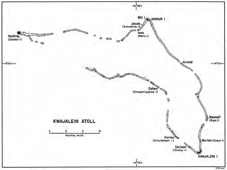
The Joint Chiefs approved these changes recommended by the theater commander and, on 14 December, Admiral Nimitz issued his revised Operation Plan 16-43, which definitely assigned Kwajalein Atoll as the target in the forthcoming operation. The 7th Infantry Division was to take the southern group of islands in the atoll, including Kwajalein Island. The 4th Marine Division was to capture Roi-Namur and the other northern islands of the atoll.11 Roi-Namur, lying at the northeastern corner of Kwajalein Atoll, is about forty-four nautical miles from Kwajalein Island, which is at the southeastern corner.
One final change in the plan was made on 26 December. Admiral Spruance, after being overruled on the question of bypassing Wotje and Maloelap, asked that Majuro, one of the easternmost of the
Marshalls, be included as an additional objective. He wanted the atoll at the earliest possible moment as a fleet base, and he believed that airfields constructed there would help cover the line of communications to Kwajalein. A Navy reconnaissance plane flying over that area in early December had drawn no antiaircraft fire and had seen no activity, thus leading Nimitz to believe that if a Japanese garrison was there, it was small. Hence, it was agreed to send a small expeditionary force consisting of 2nd Battalion Landing Team of the 106th Infantry with the 1st Marine Defense Battalion attached, and the Reconnaissance Company V Amphibious Corps to occupy the atoll.12 D Day for all landings was to be 31 January 1944.
Spruance’s Plan
As always in the Central Pacific, the highest operational command for the Marshalls invasion went to Admiral Spruance, now designated Commander, Fifth Fleet (Task Force 50).13 Once again Admiral Turner commanded the Joint Expeditionary Force (Task Force 51 ). Command of the expeditionary troops fell to General Holland Smith (Task Force 56). General Smith’s position in the chain of command in relation to Admiral Turner was made clearer than it had been in the Gilberts operation, and his authority was more precisely defined.14 He was put in direct command of all landing forces and garrison forces once they were ashore. The troop commanders of each of the landing forces, that is of the 7th Infantry Division and the 4th Marine Division, were expressly placed under General Smith until such time as Admiral Spruance should determine that the capture and occupation phase of the operation had been completed. However, General Smith’s authority as commander of expeditionary troops had one limitation. Since it was recognized that “the employment of troops, including the reserve troops engaged in the seizure of objectives, is subject to the capabilities of the surface units to land and support them,” any directives issued by General Smith as to major landings or as to major changes in tactical plans had to have the approval of Admiral Turner before they could be issued. To this extent, the expeditionary troops commander was still subordinate to Admiral Turner.15
Immediately subordinate to Admiral Turner as Commander, Expeditionary Force, were the three attack forces. The Southern Attack Force (Task Force 52), commanded also by Admiral Turner, was assigned the task of capturing Kwajalein Island and the surrounding islands in the southern half of the atoll. The Northern Attack Force (Task Force 53), commanded by Rear Adm. Richard L. Conolly, was charged with the capture of Roi-Namur and all other islands in the northern half of the atoll. The Majuro Attack Group (Task Group 51.2) was to be commanded by Admiral Hill.
Under Holland Smith’s immediate command were the three landing forces, one assigned to each of the major objectives. The Southern Landing Force (Task Group 56.1), composed primarily of the 7th Infantry Division, was commanded by Maj.
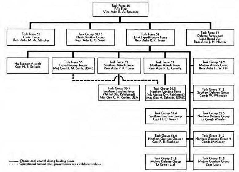
Chart 2: Task Organization of Major Commands for the Attack on Kwajalein and Majuro Atolls
Gen. Charles H. Corlett, USA. The Northern Landing Force (Task Group 56.2), consisting of the 4th Marine Division with attached units, was commanded by Maj. Gen. Harry Schmidt, USMC. The Majuro Landing Force, commanded by Lt. Col. Frederick B. Sheldon, USA, was made up of the 2nd Battalion, 106th Infantry, and the V Amphibious Corps Reconnaissance Company. At each objective the attack force commander (naval) was to command the landing force through the landing force commander (ground troops) until the situation permitted the latter to assume command ashore.
Under Admiral Spruance and parallel to Admiral Turner were three other commands. The first was the newly organized Carrier Force (Task Force 58), under Rear Adm. Marc A. Mitscher, which comprised four groups of fast carriers each with a varying number of the newest and fastest battleships, cruisers, and destroyers. The second was the Neutralization Group (Task Group 50.15), under Rear Adm. Ernest G. Small, consisting of three heavy cruisers, four destroyers, and two minesweepers. The third was named Defense Forces and Land Based Air (Task Force 57) and was commanded by Admiral Hoover. Its chief components were the Strike Command (Task Group 57.2) under
General Hale, consisting of eleven land-based Army bomber squadrons; three Army fighter squadrons; and a Marine Search and Patrol Group (Task Group 57.3) under the command of General Merritt.
As outlined in Admiral Spruance’s plan, the jobs assigned to Mitscher’s fast carrier force were manifold. The force was to move into the Marshalls area on 29 January (D minus 2) and destroy enemy aircraft and air facilities at Wotje, Maloelap, Roi-Namur, and Kwajalein. The following day it was to coordinate air operations against Wotje and Maloelap with bombardment of those islands by cruisers from Turner’s task force and Small’s Neutralization Group. At the same time, other ships of Mitscher’s force would deliver both air and surface bombardment against Roi-Namur and Kwajalein Islands. Concurrently, Eniwetok was to be denied to the enemy as an airfield. On D Day (31 January) the force was to furnish air support over Kwajalein Atoll as requested by Admiral Turner.
The job of softening up the target islands as well as other islands in the Marshalls group was assigned to Admiral Hoover’s task force. Before the fast carriers moved into the area the land-based planes of Task Force 57 were to keep Mille and Jaluit neutralized; destroy enemy aircraft and air facilities at Roi-Namur, Kwajalein, and Maloelap; mine the waters around Jaluit, Mille, Maloelap, and Wotje; furnish air support at Kwajalein on D Day as requested by Admiral Turner; and be responsible for the photographic reconnaissance of the Marshalls as directed by Admiral Nimitz. From 25 December through D Day they were to search the entire Marshalls area for enemy plane and ship movements, attack enemy ships and shipping, protect the Ellice and Gilbert Islands, and provide air transportation. Finally, to this headquarters was assigned the duty of developing the advance bases in Kwajalein and Majuro once these had been captured by ground and naval forces.
Finally, Admiral Small’s little force of cruisers and destroyers was ordered to operate off the atolls of Wotje and Maloelap and bombard those islands intermittently commencing on 29 January. The purpose of this maneuver was to deny the enemy the use of his airfields there.16
Admiral Turner’s Attack Plan
The plan for the invasion of the Marshalls differed in many important details from that for any previous amphibious operation in the Pacific. The differences resulted partly from the experiences gained in the Gilberts and partly from the fact that by this time a far greater quantity and variety of amphibious equipment had been made available to the Central Pacific forces.
No longer did the attack force commanders have to rely on the faulty communications systems of battleships to maintain proper radio liaison between ship and shore and ship and air. Two newly constructed headquarters ships, each equipped with the latest developments in radio and radar gear and unburdened by gunfire support duties, were provided for this operation. Admiral Turner at Kwajalein carried his flag aboard the USS Rocky Mount and Admiral Conolly at Roi-Namur rode the USS Appalachian. In addition, Admiral Hill was given a new flagship, the APA Cambria, which had been partially converted into a headquarters ship.
In the interim between the Gilberts and Marshalls invasions, several improvements were made in the techniques of softening up the enemy defenses before the first troops touched shore. These all added up to one factor: a great increase in both the quantity and accuracy of fire power to be delivered before the invasion. Provision was made for a longer period of preliminary aerial bombardment both from the newly acquired island bases in the Gilberts and from the newly organized fast carrier force. Naval ships and planes were ordered to move into the target area and shell and bombard enemy installations one day before the initial landings in the Marshalls and a full two days before the main landings were executed. Also, provision was made to land field artillery on islands adjacent to Kwajalein Island and Roi-Namur a day before these two main objectives were assaulted by ground troops. The field pieces were to be registered on the larger islands in time to support the assault troops as they moved from ship to shore.
To provide a last-minute saturation of the beaches, two new, or rather modified, forms of older types of amphibious equipment were introduced. The first of these was the armored amphibian or amphibian tank (LVT(A)).17 This vehicle was merely the standard amphibian tractor equipped with extra armor plating and mounting a 37-mm. gun housed in a turret. It was to precede or accompany the first wave of troops from the line of departure to the shore and provide extra fire support for them. The second was the LCI gunboat (LCI(G)). This little vessel (153 feet in length), originally designed to land infantry troops at the shore line, had been converted into a gunboat by the addition of three 40-mm. guns and banks of 4.5-inch rocket launchers. The LCI(G)’s were to precede the first wave of amphibian vehicles close into shore, firing their rockets and guns in an effort to knock out any enemy personnel and machine guns that might still be functioning on the beaches after the heavier naval and aerial fire had lifted.
Finally, a sufficient number of amphibian tractors was provided to the battalion landing teams to permit them to land their assault waves in total. This, it was hoped, would provide the necessary momentum to the assault, so noticeably lacking at Tarawa, and would eliminate the necessity of transferring assault troops from landing craft to amphibian tractors at the reef line.
To transport the troops and equipment of the 7th Infantry Division to Kwajalein Island, Admiral Turner was able to plan on a total of 11 attack transports, one troop transport ship, 3 attack cargo ships, 2 landing ships dock to carry the tanks, and 16 LSTs to carry amphibian tractors and trucks. To escort these ships to the target area and provide naval and aerial support, mine sweeping, and other functions, he had 4 old battleships, 3 heavy cruisers, 21 destroyers, 2 high-speed transports (APDs), 3 escort carriers, 12 LCIs (landing craft, infantry), and 4 minesweepers (AM’s and DMSs). About the same number of troop and cargo ships were assigned to Admiral Conolly’s Northern Attack Force to transport the 4th Marine Division to Roi-Namur. Conolly’s support shipping was less than Turner’s by one old battleship, one heavy cruiser, and eleven destroyers, but in partial recompense he was awarded two light cruisers. The Majuro Attack Group under Admiral Hill consisted of one heavy cruiser, two escort carriers,
four destroyers, one minesweeper, one attack transport, one troop transport, and two high-speed transports. The attack force reserve group, which carried the 22nd Marine Regiment and the two battalions of the 106th Infantry Regiment not assigned to Majuro, consisted of five attack transports, one troop transport, two attack cargo ships, and seven destroyers.18
Admiral Turner’s plan called for extensive prelanding bombardment both from surface ships and from the air. On D minus 1 (30 January) eight battleships from Mitscher’s fast carrier force, accompanied by about a dozen destroyers, were to deliver a dawn bombardment against Kwajalein Island and Roi-Namur. The object was to destroy aircraft, coast defense guns, and personnel, and to render the air fields temporarily useless. At the same time, two advance units of cruisers and destroyers from Turner’s task force were to bombard the airfields at Wotje and Maloelap. These dawn bombardments were to be followed by air strikes against each of the objectives. After the strikes were completed the surface ships would again take up the bombardment and maintain a steady fire until about noon.19
On D Day (31 January) the schedule called for initial landings on islands adjacent to Kwajalein and Roi-Namur upon which artillery could be emplaced for the main assaults. Cruisers, old battleships, and destroyers of Turner’s task force were to conduct an all-day bombardment against both the smaller islands and the main targets in order to support landings on the smaller islands, to destroy coastal batteries, antiaircraft defenses, and beach defenses on the main islands, and to continue the destruction of aircraft and airfield installations. Fifteen minutes before the first wave of boats was scheduled to hit the shore at Carlson (Enubuj),20 which lies just northwest of Kwajalein Island, flights of torpedo bombers, dive bombers, and fighter planes were to deliver a last-minute attack against the beaches. A similar strike was to be delivered against Ivan (Mellu) and Jacob (Ennuebing) Islands, which lie southwest of Roi-Namur.
On D plus 1 (1 February) cruisers and battleships and as many destroyers as could be spared from screening duties were to conduct bombardments in support of the main landings on Kwajalein and Roi-Namur. Other islands that could be used by the Japanese to interfere with these landings were to be kept neutralized by surface bombardment. At daylight the heavy ships were to open up with counterbattery fire to protect the transports as they unloaded the troops, and with area bombardment to destroy secondary defenses behind the beaches. As H Hour approached, destroyers and LCI gunboats were to move into very close range of the beaches. Close supporting fire for advancing boat waves as they moved in to the shore line was to be delivered by cruisers firing 8-inch and 5-inch shells from medium ranges and by destroyers and LCI(G)’s at close ranges. Cruisers were ordered to cease fire when the first wave was about 1,000 yards from the beach. Destroyers and LCI(G)’s were to continue fire until the first landing wave was 500 yards or less from the beach. Thereafter they would shift to the flanks to protect succeeding waves.
Commencing forty-five minutes before
the first waves touched shore, air strikes by the maximum available number of planes were to be carried out against the main landing beaches both at Kwajalein Island and at Roi-Namur. These were to cease twenty-five minutes before the first wave touched shore in order to allow a resumption of ships’ fire and of artillery fire from Carlson, Ivan, and Jacob. In addition to this air support provided by planes from the escort carriers in Turner’s task force, Admiral Hoover’s Task Force 57 was ordered to provide one squadron of land-based heavy bombers to attack various strong points and blockhouses, commencing sixty minutes before the first landings on the main islands.21 With this tremendous bombardment by aircraft, surface ships, and artillery, all to be executed before the first troops hit the shore line, it was hoped that the bitter experience of Tarawa would not be repeated.
The Landing Force Plans
Southern Kwajalein
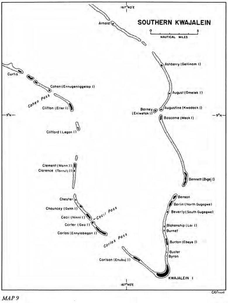
Kwajalein Island is shaped like a crescent, its concave side being the lagoon or north shore. It is approximately two and a half miles in length and averages 800 yards in width for two thirds of its length from west to east, then tapers, after bending to the north, to less than 300 yards in width at its northeastern tip. It is the largest island of the atoll.22 The island nearest to the western end of Kwajalein is Carlson (Enubuj), approximately two miles to the northwest. Next to the northeastern end are two tiny pieces of land, Byron and Buster Islands (no known native names), then the larger Burton (Ebeye), which is nearly two and a half miles from Kwajalein. Photographs and intelligence surveys showed that Carlson was weakly defended if at all, while the Burton garrison was estimated to be at least 1,000 troops. Closer scrutiny of Burton also revealed extensive prepared positions. It was estimated that there were eight antiaircraft guns near the ramps and service apron, and the island seemed to be ringed by a series of pillboxes. In the opinion of General Corlett, 7th Division commander, and of his division artillery officer, Brig. Gen. Archibald V. Arnold, the artillery could be placed on either Carlson or Burton and deliver fire on the landing beaches in support of the main assault on Kwajalein Island. The absence of defenses on Carlson made this island seem to be the more desirable, but in order to utilize the fire power of the division artillery to the fullest, it was necessary to decide at exactly what spot on Kwajalein Island the assault troops were to go ashore. Should the landing beaches be toward the northeastern end of the island, Burton would serve better for artillery emplacements, even though it was defended.
The reef along the ocean side of Kwajalein Island is from 100 to 130 yards wide and precipitous. At low tide it is completely bared and fairly smooth except near the ends of the island. Heavy surf strikes the eastern shore and rolls along the southern shore, but at the southwestern corner the swell becomes moderate, a circumstance that favored landings in that area. On the lagoon side, although the water is smooth, the reef is from 500 to 800 yards wide. Boulders and smooth coral outcroppings
Map 9: Southern Kwajalein
promised to make the approach to the lagoon beaches even more difficult than those at Tarawa or at Red Beaches, Makin. The beaches along both the ocean and the lagoon shore vary normally from ten to twenty yards in width after rising from the reef. At the two tips of the island, however, the beaches rise more gradually and are considerably more extensive, a smooth beach of coral sand extending for approximately 250 yards inland at the northeastern tip and 450 yards at the western end.
It was generally believed that the Marshalls, having been prewar Japanese territory and being nearer to the heart of Japan, would be more strongly fortified than the Gilberts. Should the prepared positions that had furnished such a costly obstacle at Tarawa be excelled by those on Kwajalein Island, the forthcoming attack would have to be carefully planned to strike the weaker portions of the Japanese defensive system. The preliminary reconnaissance had shown that the enemy had apparently long expected attack from the seaward side. But photographs taken on 4 December showed that the garrison had begun the erection of positions along the lagoon, apparently on the ground that Tarawa had been attacked from the lagoon shore and an invasion of Kwajalein might possibly come from the same direction.
After weighing these various considerations, the planners decided that the 7th Infantry Division should land at either end of the island rather than in a frontal attack against either the ocean or lagoon shore line. Because reef and surf conditions were more favorable at the western end, and because Carlson Island would probably be much easier to take quickly than would Burton, plans were laid for the division to land on the beaches at the western extremity. This would take place after the D-Day invasion of Carlson Island, where the division artillery would be placed to support the main landing on Kwajalein.23 Such a course of action would give the assault troops on Kwajalein Island the benefit of high-angle artillery fire to supplement the fire of the flat-trajectory naval guns.
Three other small islands in addition to Carlson were to be captured during the preparatory phase of the operation. These were Carlos (Ennylabegan), Carter (Gea), and Cecil (Ninni) Islands, all lying north of Carlson. They guarded Cecil Pass, the best deep-water channel into the lagoon at southern Kwajalein, and were thought to be lightly defended, if at all. It was Admiral Turner’s desire to move many of the transports and fire support vessels into the lagoon, where they would be protected from submarine attack and where naval gunfire could be brought to bear directly on the lagoon beach defenses. The 7th Division’s operation order, therefore, called for the capture of four islands during Phase I, which was to begin on D Day, 31 January.24 Artillery was to be landed on Carlson and moved into firing position at the earliest possible moment after troops had landed.
The assault on Kwajalein Island, the main objective, was to take place on the morning of D plus 1 (1 February) if, by then, Carlson had been captured and the artillery placed in position. By close planning between division artillery representatives, Army and Navy air services, and naval gunnery officers, all bombardment and naval gunfire and Army artillery support were carefully coordinated for the support of the main attack. Following a preliminary (prelanding) bombardment of one hour, each type of fire would lift inland.
Army artillery would be nearest in advance of the troops; naval gunfire next; and the aerial coverage still farther inland.25
The 7th Division had no organic 155-mm. howitzer battalions, but during the planning stage the 145th Field Artillery Battalion was attached for the operation. During the night of D Day (31 January-1 February) the 145th and two other field artillery battalions were to deliver interdictory fire from Carlson on all the principal fortified areas of Kwajalein Island and place counterbattery fire on any enemy artillery that might be emplaced on Burton. They were also to fire general support missions for the infantry.26
The reduction of Kwajalein Island itself was to constitute Phase II of the 7th Division operations. In the allocation of targets, the 7th Division had been assigned all islands south of the line running between Arnold Island in the eastern side of the atoll and Cohen (Ennugenliggelap) Island in the western side. Of these, Burton was believed to be the only one besides Kwajalein defended by a sizable garrison.
Plans for Phases III and IV to complete the conquest of southern Kwajalein were laid, but the time of execution was to depend upon progress made in Phase II. The forces that were to seize Cecil, Carter, Carlos, and Carlson on D Day would then constitute a reserve for landing teams operating on Kwajalein Island.27 Once the need for this reserve had passed, the forces could be committed in Phase III, the reduction and occupation of Burton Island and the investigation of Buster, Byron, Burnet, and Blankenship (Loi) Islands. The final phase was to include the seizure of Beverly (South Gugegwe), Berlin (North Gugegwe), Benson, and Bennett (Bigej) Islands in the eastern chain.28
To accomplish its mission at southern Kwajalein, the 7th Division was organized into nine battalion landing teams, each consisting of three rifle companies, a heavy weapons company, a platoon of engineers from the 13th Engineer Battalion, a platoon of medium tanks from the 767th Tank Battalion, a platoon from one of the regimental cannon companies, and small detachments of service troops.29 A tenth landing team, for use against small objectives, was formed by the 7th Cavalry Reconnaissance Troop and Company B, 111th Infantry, a regiment that was part of the prospective Kwajalein Garrison Force but had been attached to the division for the assault phase of the operation. In the event that a battalion landing team was called upon to act separately, it could be made self-sufficient by the addition of a shore party team.
With the prospect of different elements of the division operating at widely scattered points in the atoll and depending on many varied arms for support, communications promised to be a major difficulty. This problem was anticipated. A provisional communications unit, known as the 75th Joint Assault Signal Company (JASCO), was organized for the 7th Division, and elements of the 295th JASCO were furnished to the 106th Regimental Combat Team.30 The 75th Provisional JASCO, made up of the 75th Signal Company reinforced by naval and air force
personnel, totaled 592 officers and men. It was to coordinate naval gunfire support missions and direct air strikes, whether performed by land-based bombers of the Army Air Forces or carrier-based planes of the Navy. It was also the channel through which troops ashore communicated with command posts afloat.
For operational purposes the 75th Provisional JASCO was divided into a headquarters, ten shore and beach party teams, and nine shore fire control teams. Each of the shore and beach party teams would serve with a battalion landing team and would be made up of thirty-two men, drawn from both Army and Navy. The nine shore fire control teams, composed of Navy officers and Army signal men, were to be distributed among the nine assault landing teams. Also operating with, but not a part of, the 75th JASCO were thirteen air-ground liaison teams of five men each. Each battalion received one of these teams, the other four being apportioned among the various regimental headquarters and division artillery. Seventy-nine men of the 75th Provisional JASCO were retained by division headquarters to perform administrative functions and coordinate work of the various teams.
For the Kwajalein Island operation, enough LVTs were provided to carry the first four waves of assault troops into the beach. A total of 174 amphibian vehicles was assigned to the 7th Infantry Division. Of these, 79 were amphibian tanks (or armored amphibians) mounting 37-mm. guns and designed primarily for close support of the first waves both during and after the ship-to-shore movement. The remainder were standard amphibian tractors. For this operation, the tanks and tractors were divided into four combat tractor groups, each with 14 amphibian tanks and 90 amphibian tractors, plus one additional detachment of 17 amphibian tanks to be distributed among the four groups as the situation required. Twenty-one vehicles were placed in a reserve LVT pool that was to provide immediate replacement to the combat tractor groups. One of the tractor groups was assigned to the D-Day landings on Carlson Island and one to Carlos Island. Two were assigned to Kwajalein Island for the D-plus-1 landings. After carrying the troops of the first four assault waves to the beaches, the tractors of these groups were either to support the infantry advance inland, or, in the case of Kwajalein Island, were to return to the reef line and pick up reserve troops boated in standard landing craft.31 By these measures, it was hoped to guarantee an uninterrupted movement of the assault troops from ship to shore and an avoidance of the breakdown of momentum such as had occurred at Tarawa.
The first phase of the operations of the Southern Attack Force was to open with a predawn landing of one platoon of the 7th Cavalry Reconnaissance Troop on each of the two channel islands, Carter and Cecil. These landings were to be accomplished with the greatest secrecy, and the conquest of the outposts was to be completed as quickly as possible before the defenders could reinforce the garrisons that might be there. The reconnaissance troop was embarked on two high-speed transports (APDs), along with two platoons of Company B, 111th Infantry. The landings were
to be made in rubber boats that would be paddled ashore from 800 yards off the beaches. The men would go over the side of the APDs into their landing craft and land at 0330. It was hoped the capture would be completed shortly after daylight. The next moves of the first phase were to be the simultaneous landings on Carlos and Carlson Islands. The 1st Battalion, 17th Infantry, was to land on the former while the 2nd Battalion, 17th Infantry, invaded the latter. The 3rd Battalion, 17th Infantry was to be held in reserve, ready to go to the aid of either landing team. While the capture of Carlson Island was in progress, the division artillery, loaded for the most part on amphibious trucks, was to debark and proceed to a rendezvous area offshore. Upon a signal from the commander of the Carlson landing force, the guns were to be moved ashore and into position.
The major part of the Southern Attack Force plan was that dealing with Kwajalein Island, the main objective. After the landing on the western tip of the island with the two regimental combat teams abreast—the 184th on the left and the 32nd on the right—the attack was to proceed directly up the axis of the island with the boundary between regiments drawn roughly along a line that divided the island into halves. In the left zone of action the assault force would consist of the 2nd and 3rd Battalions, 184th Infantry; in the right zone the 1st Battalion, 32nd Infantry, was to make the initial landings. The 1st Battalion, 184th Infantry, and the 2nd and 3rd Battalions, 32nd Infantry, were to be held either at the line of departure or in the lagoon ready for use in later aspects of the attack.
Phases III and IV were dependent upon the progress of the attack on Kwajalein Island. The 17th Regimental Combat Team, upon conclusion of the Carlson and Carlos invasions, was to be held as division reserve for the landings on the main island. If it became evident that operations there were going well and the 17th would not be needed, the capture of the remaining islands could proceed, using battalion landing teams of this reserve regiment and the 7th Reconnaissance Troop.32 Operations in the last two phases were not clearly defined as to tactics; the exact procedure to be used was left until the target was reached and a closer survey made.
Northern Kwajalein Atoll
The plans drawn up by the 4th Marine Division for the capture of Roi-Namur and the adjacent islands in the northern half of Kwajalein Atoll were similar in most respects to those of the 7th Division. The only important difference in the landing plan stemmed from the choice of beaches. Whereas the 7th Division proposed to land on a narrow front on the west end of Kwajalein Island and fight its way up the long axis of the island, the 4th Marine Division was able to undertake a more orthodox amphibious maneuver and land two regiments abreast on a broad front on the lagoon shore of Roi-Namur.
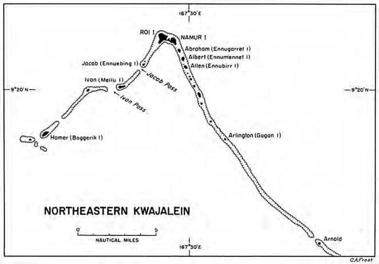
Roi Island measures 1,250 yards north and south by 1,200 yards east and west. At the time of the landing it was almost entirely cleared and was the site of the largest enemy airfield in Kwajalein Atoll. The field had three runways and was shaped in the form of a figure 4. It also had four turning circles, two service aprons, two hangars, numerous service buildings, a
Map 10: Northeastern Kwajalein
control tower, and some thirty revetments. The dispersal area covered practically the whole island. Namur Island, located 500 yards southeast of Roi, is connected with the latter by a sand beach on the lagoon (southern) side and a causeway between the islands halfway between the lagoon and ocean beaches. The island measures approximately 900 yards east-west and 800 yards north-south. Unlike Roi, it was heavily wooded at the time of the landings, in spite of the fact that it contained a large number of buildings.
The beaches along the seaward side of Roi and Namur, as elsewhere in the atoll, are approached over a reef from 125 to 400 yards wide that falls away sharply to seaward and has a ragged outer edge. This reef, plus the fact that surf on Roi-Namur’s ocean coast was extremely heavy, made landings from that side unfeasible. The only possible location for a landing, therefore, was from the lagoon where the reef fell gradually and was under water at high tide, and where there was no considerable surf.33
The 4th Marine Division’s plan of attack closely paralleled that of the 7th Infantry Division in the south. On D Day, while the Southern Attack Force would be busy with the capture of islands adjacent to Kwajalein, the 25th Marine Regimental Combat Team, commanded by Brig. Gen. James L. Underhill, USMC, would
capture five islets near Roi-Namur. Two of these guarded passes into the lagoon. The most important of the northern channels was Ivan Pass guarded by Ivan (Mellu) Island, about five miles to the west of the main base at Roi. A nearer pass was also guarded by Ivan as well as Jacob (Ennuebing) Island, from which it took its name. Just to the southeast of Namur lay five other islets, three of them large enough to be usable, the other two being simply reef outcroppings. The three larger were named Abraham (Ennugarret), Albert (Ennumennet) and Allen (Ennubirr). These three, as well as Ivan and Jacob, were thought to be suitable for the emplacement of artillery.34
On D Day, General Underhill’s landing group was to seize Jacob and Ivan Islands and establish thereon the 3rd and 4th Battalions of the 14th Marine Regiment (Artillery). Thereupon, the group was to move to Albert and Allen Islands where the other two battalions of the Marine artillery regiment were to be emplaced. The occupation of these islands, none of which was expected to be heavily defended, was to be completed before darkness on D Day.
On the next day the main landings were to take place on Roi and Namur. The 23rd Regimental Combat Team was ordered to land two regiments abreast on Red Beaches 2 and 3 on the lagoon shore of Roi. The 24th Regimental Combat Team was to conduct simultaneous landings on Green Beaches 1 and 2 on the lagoon shore of Namur. The third and final phase of the operation would include capture of the remaining islands in northern Kwajalein and would be conducted on order depending upon the speed with which the main objectives were attained.
These landings would of course follow the same intense aerial, naval, and artillery preparatory fire outlined for southern Kwajalein. The assault troops would all be boated in amphibian tractors, which would be preceded by a wave of LCI gunboats and a wave of armored LVTs. The LCI(G)’s were instructed to proceed to within 1,000 yards of the beach, fire their rockets, and continue to support the landing of troops by gunfire. The armored amphibians were to pass through the LCI(G)’s and open fire with their 37-mm. guns and machine guns. Finally, the amphibian tractors mounting the infantry were to follow the armored amphibians and pass through them if the latter had to be stopped short of the beaches. Tanks, boated in LCMs, would follow the first waves of troops.35
Coincident with the seizure of Kwajalein, the separate task group (Task Group 51.2) under Admiral Hill was to invade Majuro Atoll. This force was made up principally of the 2nd Battalion, 106th Infantry, from the 27th Infantry Division, and the V Amphibious Corps Reconnaissance Company. Majuro was thought to be lightly defended, perhaps not at all. For this reason, plans for the occupation of the atoll were dependent upon the results of a preliminary reconnaissance to be carried out by the reconnaissance company on D Day after its seizure of Calalin Island, which guarded the principal entrance pass into the lagoon.36