Chapter II: The Marianas
In History
The islands thus chosen as the next point of American amphibious assault in the Central Pacific had had a long and not altogether happy experience as minor pawns in the international rivalries of great powers. Magellan discovered them in 1521 in the course of his famous first voyage around the world. Struck by the sailing powers of the native boats and by the similarity of their rigging to that of the small craft that abounded in his own Mediterranean, the navigator labeled his discoveries, “Islas de los Velas Latinas” (Islands of the Lateen Sails). Other members of the expedition were more impressed by the natives’ pilfering habits and accordingly called them “Islas de los Ladrones” (Islands of the Thieves), a name that remained in popular usage well into the twentieth century, even though it had long since been officially abandoned. Late in the seventeenth century the islands were officially renamed “Las Marianas” in honor of Maria Anna of Austria, wife of Philip IV and Queen of Spain, who took a personal interest in converting their inhabitants to the Church of Rome.1
The original native population of the Marianas, the Chamorros, were a hardy race, probably of Polynesian origin, but not hardy enough to withstand the encroachments of western civilization as represented by Spanish traders and missionaries. In spite of mass baptisms by the latter, native resentment toward the rigid rule of the priesthood increased until finally, in the 1690’s, armed revolution broke out in the islands. The result was inevitable; the Spaniards with their superior weapons and organization overcame the rebels, killed large numbers and forced most of the remainder to flee. The center of the trouble was on Guam, and from there many of the remaining Chamorros fled to the northern Marianas, where they were relentlessly pursued and persecuted. Others finally escaped south to the Carolines to become intermingled with the Kanaka population of those islands.
Spanish control, which had become progressively weaker during the nineteenth century, was finally severed completely in 1898-99. Imperial Germany was the first of the Western Powers to challenge Spanish
hegemony in Micronesia.2 In August 1885 the Germans hoisted their flag over Yap in the western Carolines and laid claim to much of the surrounding territory. After violent Spanish protest, the dispute was submitted to papal arbitration and Spain’s sovereign rights were confirmed, although Germany obtained important commercial concessions at the same time. Negotiations for transfer between the two countries continued in the 1890s, and in 1899 Spain ceded all of her possessions in the Carolines, the Marshalls, and the Marianas to the German Empire for the sum of about $4,000,000. Meanwhile, a small American naval expeditionary force had seized Apra Harbor on Guam, and at the termination of the Spanish-American war that island was ceded to the United States.
Another radical change in the disposition of the entire Central Pacific area occurred as the result of World War I. Japan, having emerged successfully from her recent war against Russia and being anxious to expand her commercial and military influence throughout the Orient and its adjacent waters, was quick to seize the opportunity of a European war to realize her own imperialist ambitions. As one of the Allied Powers, Japan contributed her share to the ultimate downfall of the German Empire by seizing the Carolines, the Marshalls, the Palaus, and the Marianas (except, of course, Guam) in the first year of the war. Then, under the Treaty of Versailles, all former German possessions north of the equator were mandated to Japan, although they theoretically still remained under League of Nations authority. During the 1920’s and 1930’s the Japanese proceeded vigorously to colonize these new holdings and to exploit their economic resources for the benefit of Japanese economy. After 1935, when Japan withdrew from the League of Nations, no further effort was made to give even lip service to the idea that the islands were mandated territories. They became, to all intents and purposes, outright possessions.3
Meanwhile, the United States had occupied Guam and had converted it into a minor naval base. By an executive order of President William McKinley dated 23 December 1898, the island was placed under control of the Navy Department, a naval officer was commissioned as governor of Guam, and the same officer was appointed by the Secretary of the Navy as commandant of the naval station, which encompassed the entire island. Progress in constructing a naval base of respectable proportions was slow and halting. In 1939 the Hepburn Board reported to Congress that the area should and could be developed into a major naval base, but the necessary appropriations failed to pass.
The Japanese Invasion of Guam
At the time of the outbreak of war between the United States and Japan, the American garrison on Guam consisted of 153 marines and 271 U.S. Navy personnel, supported by a force of 308 Guamanians. The garrison had no artillery or fixed defenses and, in addition to its small arms, possessed only a few .30-caliber and .50-caliber machine guns. The local naval surface force consisted of three small patrol
craft and an old oiler. One of the patrol craft, the USS Penguin, mounted two 3-inch antiaircraft guns and the oiler boasted two .50-caliber antiaircraft machine guns.4
Japanese designs against this tiny force and the outpost that it garrisoned began to materialize well before the attack on Pearl Harbor. As early as the middle of October 1941, the 18th Air Unit, a small force of reconnaissance seaplanes based in the Marianas, began conducting a reconnaissance of Guam and during the following 1 November flew frequent secret photo reconnaissance missions over the island at altitudes of 3,000 meters or higher.5 At the same time, small Japanese vessels began patrolling the waters around the island, mostly at night, and in early December succeeded in landing several native Guamanians friendly to their cause.
Japanese plans for an amphibious invasion of Guam were complete by 8 November. On that date Maj. Gen. Tomitara Hori, who commanded the South Seas Detachment, a unit of about 5,500 Army troops, received his orders. He was to assemble his forces in the Bonins in November and wait there until definite word of the first Japanese air attack against the United States had been received. Then, naval air units based on Saipan were to fly to Guam and attack U.S. ships and installations. Meanwhile, Army troop transports with a naval escort were to proceed from the Bonins to Guam, where landing operations would commence in the early morning of 10 December. In addition to the Army troops assigned, the Navy was to contribute a special landing force of about 400 men drawn from the 5th Defense Force stationed on Saipan.6
The planes assigned to softening up the target came to about twenty in number, including the 18th Air Unit, which had been busy on reconnaissance missions over the island since October. At 0525 on 8 December word came to the airmen waiting on Saipan that the Greater East Asia War had begun. The message read, “Begin attack on Guam immediately.”7 The shooting war in the Marianas had started. It would not formally end for another two years and nine months.
Within three hours of receiving this command, Japanese planes bore down on Guam and bombed the American oiler Barnes in the harbor. Next they turned their attention to the patrol boat Penguin, which was attempting to escape to the open sea, and finally they dumped their remaining bombs over shore targets. Penguin was sunk and Barnes damaged to
the extent that she had to be abandoned. A second flight appeared over the island at 1330 the same afternoon, the planes concentrating their attack on the still unsunk Barnes and the cable and wireless stations ashore.
The following day, Japanese aircraft again made morning and afternoon raids. Two bombs struck the Marine barracks, and many other hits were scored. The Japanese airmen reported that fire from the ground was very light and that they had spotted no artillery emplacements and no mines in any of the harbors or bays – only a machine gun position in the northern suburbs of Agana. (See Map V.)
While Guam burned under the bombs of its attackers during the first two days of the war, the troop-laden assault vessels and their escorts were on the way down from the north. At 0900 on 4 December, the main elements of the convoy, carrying the 5,500 Army troops, moved out of Hahajima and headed toward Rota, where they were joined by the ships carrying the small naval detachment from Saipan. From Rota the force advanced in separate groups to Guam, where all arrived during the first hour of 10 December. Landing operations commenced at 0230. The main force of the Army troops landed on the west coast between Facpi Point and Merizo, intending to drive northward along the coast to Agat. This plan miscarried when it was discovered that there was no adequate road from the beachhead to Agat, and the troops had to re-embark and land again at Facpi Point. The maneuver proved superfluous since by the time the new landing was completed the American garrison had already surrendered to the smaller naval unit.
The naval detachment landed about two miles north of Agana. As it advanced toward the city, it flushed the machine gun emplacement reported by planes the night before, about one kilometer from the city itself. The main body of the U.S. marines had taken positions at the Marine rifle range on Orote Peninsula, and only about eighty Guamanians and a few Americans were in Agana when the Japanese arrived. These few put up a stiff fight and twice at Agana Plaza drove the invaders back with rifle and machine gun fire before finally being overcome. After the skirmish on the plaza, the Japanese went on to occupy the naval hospital and the wireless station, and the naval repair station at Piti. Finally, at 0545 the island governor, Capt. C. J. McMillin, USN, realized that resistance was useless and commenced negotiations for surrender. Soon after, the American ensign was run down from Government House and replaced by the Imperial flag of Japan. The Japanese had completed the occupation of the Marianas chain.8
Description of the Islands
The Marianas are a chain of volcanic islands running in an approximately north-south direction from 20° 32′ N, 144° 54′ E to 13° 15′ N, 144° 43′ E. From Farallon de Pajaros in the north to Guam in the south, the chain numbers fifteen islands in all. Guam has an area of over 200 square miles but about two thirds of the chain is little more than mountainous rocks and of practically no military value.
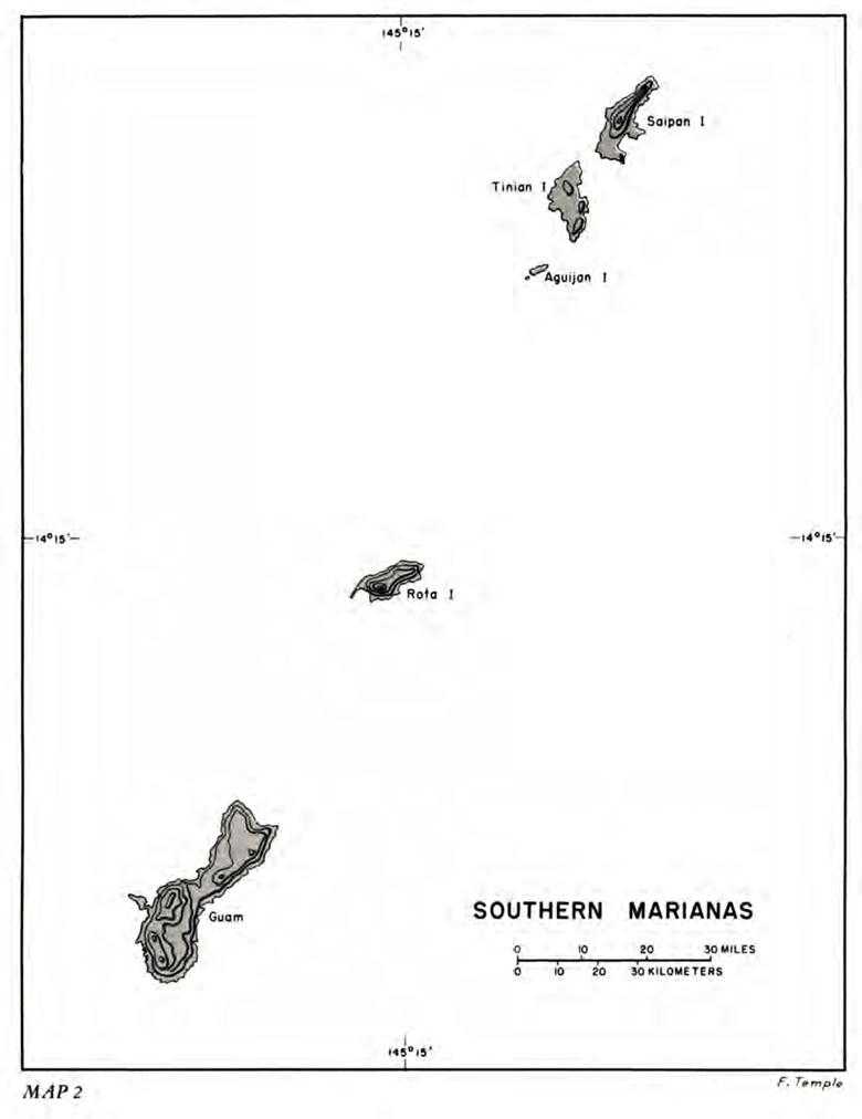
Map 2: Southern Marianas
The four largest islands and those having the chief military utility are all in the southern half of the chain. These, from north to south, are Saipan, Tinian, Rota, and Guam. (Map 2) Of these, Rota was eliminated by the U.S. planners as a feasible target because of the inaccessibility of most of its coast line, its inadequate harbor facilities, and its general inferiority to the other three islands as a naval and air base for future operations against Japan.
Saipan, Tinian, and Guam lay directly athwart or on the near flank of the advance of Central Pacific forces from their westernmost base at Eniwetok to almost any part of Japanese-held territory that might become the object of future amphibious operations – the Philippines, Formosa, the Volcano Islands, the Ryukyus, and Japan proper. Saipan lies about a thousand nautical miles west of Eniwetok and over 3,200 miles from Pearl Harbor. Northwest, Tokyo is only about 1,260 miles distant, and Manila Bay is 1,500 miles almost due west. Tinian is just three miles south of Saipan; Guam, approximately another hundred miles in a southerly direction. The main geographic factors that planners of the operation had to take into consideration were climate, the location of beaches and the approaches thereto, topography of the terrain inland from the beaches, the nature of the vegetation as it would affect military operations, harbor facilities, the location and size of towns and cities, and the location of roads, railroads, and other transportation facilities. The necessary information was gleaned from a variety of sources – prewar surveys and hydrographic charts, aerial and submarine reconnaissance missions executed during the war, and enemy documents captured in earlier operations.
The first aerial photographs of Saipan and Tinian were taken on 22 and 23 February 1944 by planes flown from Marc Mitscher’s fast carrier force (Task Force 58). At that time, a total of twenty-five sorties at various heights and angles was flown, but because of cloud formations only a partial coverage of the islands was obtained.9 These were supplemented by full photographic coverage provided by a flight of five Navy PB4Y’s, escorted by Army bombers, that took off from Eniwetok on 18 April for a round trip of more than two thousand miles and thirteen hours in the air. A second mission flown by a similar group of planes on 25 April also photographed Guam.10 Guam was covered again on 7 May by six Navy photographic “Liberators,” and the northern islands as well as Guam were re-photographed on 29 May.11
In addition, the submarine USS Greenling made a series of sorties around all three islands between 2 and 29 April and obtained excellent photographs, which were made available to the expeditionary troops. The submarine’s photographs were chiefly remarkable for their accuracy of detail on the beach approaches.12
Between 15 January and 10 May, Joint Intelligence Center, Pacific Ocean Areas (JICPOA), issued a total of eight information
bulletins covering the proposed island targets.13 In addition, the Office of Naval Intelligence (ONI) made available a monograph on the geography of the Palaus and the Marianas that had been prepared in the spring of 1942.14 More detailed was another ONI bulletin on Guam that was an exhaustive, although somewhat obsolete, study based chiefly on a monograph completed by Marine Corps Schools in Quantico as early as 1937 and the notes and personal recollections of a naval officer, Comdr. R. F. Armknecht (CEC) (USN), who had left the island only a month before the Japanese captured it.15 Other materials, including diagrams of tides, sunlight and moonlight tables, and captured Japanese charts, completed the list of information on the Marianas upon which plans for the landings had to be based.16
Some of this proved to be inaccurate in detail. The number of enemy installations and the size and disposition of troops were generally underestimated. Many terrain features were erroneously depicted in the maps made on the basis of photographic intelligence. On the whole, however, a fairly good general understanding of the nature of the targets could be gleaned from the various sources.
Climatic conditions vary little as between the sister islands of Saipan and Tinian in the north and Guam in the south. The year can be conveniently divided into two seasons: the dry or winter monsoon season from November through March, and the wet or summer monsoon season from April through October. During most of the dry period the prevailing wind is from north and east with an average velocity of ten to fifteen knots. By June the wind usually shifts from east to south and by August and September the southwestern monsoon frequently occurs. Thus, if landings on the western beaches were to be considered, it was clear that they should be made before August in order to be certain of a lee shore.
Average cloud cover is nearly 70 percent for most of the year, which added to the problem of achieving adequate aerial observation and aerial reconnaissance. Generally, however, weather conditions offered no serious obstacle to military operations. The climate is mild and healthful. Mean temperature on Saipan varies between a January maximum and minimum of 81° F. and 72° F., respectively, and June values of 85° F. and 75° F. Guam, being a hundred miles closer to the equator, is somewhat warmer and more humid but not enough so to make any significant difference. The summer months constitute the rainy season, during which the total precipitation is from 80 to 86 inches. Most rain falls in the form of showers, lasting from only a few minutes to two hours, but there are occasional steady, light rains. August is the wettest month – an additional reason for concluding any proposed military operations before the end of July. Typhoons occur in the area, but not with as much regularity or intensity as elsewhere in the Pacific. This is a region of typhoon genesis and storms are usually not
fully developed. About once every two years disturbances of the typhoon type hit the islands or pass near enough to cause violent winds and heavy rainfall, but even so the storm diameter is generally comparatively small.17
None of the three islands offered ideal beach conditions for landing assault troops. On Saipan the land on the western side slopes rather gently up from the shore line, but the beaches themselves could be reached only with difficulty because of fringing and barrier reefs that extend for most of the island’s length. (See Map I.) A small gap existed in the reef just off the town of Charan Kanoa and a dredged channel led into Tanapag Harbor, but for most of the area the coral barrier presented a serious impediment to the landing of troops boated in small craft. The north end and east side of the island have deep water close inshore and are free of reefs except for a fringing one around Magicienne Bay on the east coast. However, the beaches were generally narrow and the shores steep, thus making landing operations and movement inshore extremely hazardous. The same conditions prevailed for the most part on the southern end.
Harborage facilities ranged from poor to mediocre. Tanapag Harbor, the principal anchorage area, was the only one that provided even partial protection from all winds, and against heavy seas from the west the reef barrier on the seaward side offered little real safety to ships at anchor within. Vessels could anchor off Garapan and find some shelter from easterly winds and sea, but it was no more than an open roadstead, and landing and unloading would be impossible during strong westerly winds. The only shelter against northerly and westerly winds was at Magicienne Bay on the southeast coast. However, the bay was deep and open to winds and seas from the southeast.18
Tinian was even better equipped topographically to resist an amphibious landing. The main obstacle to invasion was an almost unbroken barrier of abrupt cliffs close to the water line and ranging from a few feet to over a hundred feet in height. Although the cliffs were not unscalable, especially along the northern and western shores, there was very little landing space at the water’s edge for small craft, and the flow of supplies inland from such narrow beaches would be seriously handicapped. The cliffs were broken at various spots in the neighborhood of Tinian Harbor and again on the northwest coast and along the northeastern shore line, but none of these locations offered ideal landing conditions.19 (See Map IV.)
Guam, like the other islands of the Marianas, presented to would-be invaders the combined hazards of reefs and shore-line cliffs. The northern half of the island was virtually inaccessible to amphibious troops because of the reef, the surf, and the sheer cliffs rising from the beaches. Although there were some possible landing points on the southeast and southern coasts, the most practicable beaches were south of Orote Peninsula and north of the naval station at Piti, both on the southwest coast. These were obstructed by barrier reefs and, in the north, by low-level cliffs, but were at least negotiable by amphibian craft and
vehicles. The only good harbor was at Port Apra, north of Orote Peninsula. The port was protected by the peninsula proper, by Cabras Island on the north, and by a breakwater extending from the island, and was considered safe from wind and sea from almost any direction except during the typhoon season.20
Although terrain features inland from the shore line on each of the islands were in some ways unique, the similarities were more marked than the differences. The most distinct characteristics of all the Marianas, at least to seasoned troops, were to be their novelty and variety. Heretofore, practically all operations of American forces in the Pacific had been confined to tropical jungle or to coral atolls where maneuver was limited either by the denseness of the vegetation or by the smallness of the area to be seized. Now American troops were to find themselves maneuvering over moderately large land masses with highly varied topography and vegetation. They would have to fight their way through mangrove swamps and fields of lashing sword grass and sugar cane; through fairly sizable towns where the enemy might have to be routed by house-to-house fighting; and, finally and worst of all, up and down precipitous volcanic mountains pocked with caves and creased with endless ridges, escarpments, and other natural concealments that the enemy could be expected to exploit to the fullest.
The dominating physical feature of Saipan is Mount Tapotchau, which rises to an elevation of 1,554 feet near the center of the island.21 Between this summit and Mount Marpi, located at the north end of the island and having an elevation of 832 feet, there is a ridge over seven miles long with peaks ranging between 720 and 934 feet. To the west of this ridge there is a fairly level coastal area in the region of Tanapag Harbor, but to the east the slope ends abruptly in steep coastal cliffs. South and southeast of Tapotchau, the backbone ridge slopes off into the plateau forming Kagman Peninsula on the eastern and the southern third of the island. In the southern area Mount Kagman, on the east, and Mount Nafutan, on the southern peninsula of the same name, form conspicuous headlands. Approximately 70 percent of the island’s 85 square miles was under sugar cultivation at the time of the invasion. Cane can present a serious obstacle to troops, impeding movement by foot, limiting fields of fire, and offering excellent concealment for the defenders. Another obstacle to attacking troops, especially from west coast beaches, was an extensive marsh that was inland from the town of Charan Kanoa and centered on freshwater Lake Susupe. Saipan is better than fourteen miles along its north-south axis and about six miles across at its widest point.22
Tinian is somewhat smaller, being about 10.5 miles in length and 5.5 miles in width at its widest point. Its terrain is also considerably less difficult for military operations than is that of its sister island. It is basically a broad elevated limestone plateau, the highest point of which is Mount Lasso (564 feet) in the north-central part. Most of the southern end of the island is of rolling hills and flatlands except for the southernmost tip, which is marked by precipitous cliffs and ravines. At the time
of the invasion about 90 percent was in sugar cane and the remainder, along the rocky slopes between the broad terraces and along the coasts, was covered with dense vegetation.23
Guam, the largest of the Marianas, is 32 miles long and from 4 to 8 miles wide, with a total surface of over 200 square miles. The northern half is a large coral limestone plateau sloping upward from the lowlands in the middle of the island between the town of Agana on the west coast and Port Pago on the east. It is broken in the south by Mount Barrigada and in the east-central section by Mount Santa Rosa, which rises to an elevation of 870 feet. The southern half of the island is characterized by broken mountain country. Inland from Apra Harbor on the west coast below Agana lie the mountain peaks of Chachao, Alutom, and Tenjo, all above a thousand feet in elevation. South of these peaks and opposite Agat Bay, the ridge slopes down to a 400-foot saddle and then rises again at the southern end of the island to elevations of over 1,200 feet. On the westward side the range slopes steeply to low foothills and narrow belts of lowlands. On the east the slopes are more gradual, ending in a plateau about 400 feet high stretching to the coastal highlands, which rise in steep bluffs from a narrow coastal flat. Five streams pierce the plateau in their eastward course. The highlands of the southern half of Guam are largely volcanic rock except for Orote Peninsula and Cabras Island on the west coast and the east coastal regions, all of which consist of coral limestone. Most of southern Guam, volcanic in origin, was covered with breast-high sword grass, and sparse scrub growth. In the coral limestone regions were found weeds, trailing vines, and tropical vegetation thick enough to make even roads impassable if not cleared continuously. In addition to these undesirable features, the coastal areas abounded in marshes and lowlands that were usually cultivated as rice paddies and that were either deep in mud or covered with cogon grass and weeds reaching heights of fifteen to twenty feet. In short, Guam even more than the other islands of the Marianas contained a superabundance of terrain difficulties to harass and impede the progress of attacking troops.24