Part Two: Invasion
Blank page
Chapter 4: Establishing the Beachhead
Considered as one event in the Allied campaign against Japan, the assault on Luzon contained within itself great strategic significance. But to the Sixth Army, the attack across the Lingayen Gulf beaches was a tactical introduction to the Southwest Pacific Area’s strategic goal – the recapture of the Central Plains-Manila Bay region. The landing would serve General Krueger’s forces as the means to secure a base area into which to pour supplies and reinforcements, on which to establish air support units, and from which to launch subsequent offensives against the main body of the Japanese 14th Area Army. Accordingly, Sixth Army had limited initial objectives. It would secure the terrain within the confines of the Army Beachhead Line and simultaneously deploy to safeguard its flanks against Japanese counterattack. Detailed planning did not extend beyond this preliminary stage. Sixth Army had only the barest outline of a plan for operations inland from the beachhead line – an outline based upon a concept developed at GHQ SWPA. This concept called for Sixth Army to push generally southward from the Lingayen assault beaches and secure crossings over the Agno River, the first major natural defensive barrier on the way to Manila. Once poised along the south bank of the Agno, Sixth Army would prepare to strike on southward toward Manila and Manila Bay. The manner in which the drive beyond the Agno would be conducted was left for future determination depending upon the developing tactical situation on the rest of Luzon.
The Assault: S-day – S Plus 2
First light on S-day, 9 January 1945, revealed an impressive armada of Allied vessels in Lingayen Gulf. The day dawned with a light but broken overcast. Visibility was excellent. Regular, gentle swells lent an aspect of serenity to the gulf’s waters, and the surf breaking along the gulf’s shores was neither high nor rough. As the sun rose higher, a touch of heat in the tropical dawn became more marked – a man could easily feel that on shore the day might wax as hot as the hinges of hell before evening brought relief. Weather conditions, if anyone aboard the ships of the assault convoys thought to make the comparison, were far different from those the Japanese had encountered at Lingayen Gulf in December 1941. The Japanese had gone ashore during dark, predawn hours through heavy, rough surf. Black skies and intermittent rain squalls had reduced visibility almost to the vanishing point, and the gulf’s choppy waters
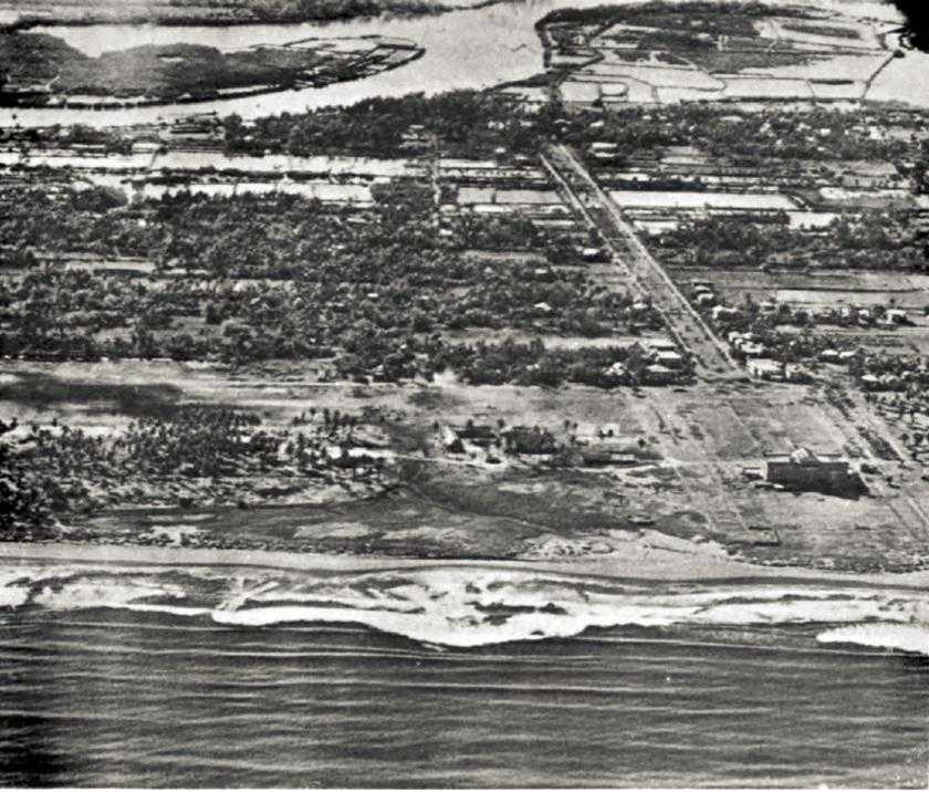
Southern Landing Beach At Lingayen. Note provincial capital building, lower right
had thoroughly doused the invaders with chill spray.1
On 9 January 1945 the American assault troops awaiting debarkation from their transports could observe to their front (south) a generally flat vista broken only by the taller buildings of the towns of Lingayen and San Fabian. It was impossible even to guess what this featureless terrain might hold in the way of Japanese; the imagination could run riot as smoke, dust, and fires from preassault air and naval bombardment rose to obscure the shore line. To the left, ominously brooding, lay the grassy, open foothills of the gulf’s eastern shore. Beyond these hills rose terracelike tiers of towering mountains that appeared at a distance to be heavily forested. It was only too easy for troops of the I Corps, coming in on the Sixth Army’s left, to imagine what those dark mountains would contain. On the right the men of the XIV Corps had a view of the
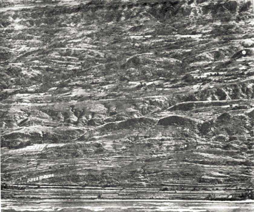
Looking inland, eastern shore of Lingayen gulf
lower, more wooded hills of the Bolinao Peninsula, forming the western side of Lingayen Gulf. No need to worry much about the peninsula yet – no assault was scheduled for that side of the gulf and available intelligence indicated that few, if any, Japanese were located there. Yet, all in all, a man with a good pair of field glasses could decide for himself that this assault could be a sticky affair. Hills and mountains dominated both the eastern and the western flanks of the landing beaches, and the mountains stretched off southward (on the west) and southeastward as far as the eye could reach. Would the Japanese hold the flat land to the front? Would they defend the hills and mountains? Or would they launch counterattacks from yet invisible mountain valleys?
Ignoring the speculations of the assault infantry, the guns of naval fire support vessels began their S-day bombardment on schedule at 0700. At first the battleships, cruisers, destroyers, LCI(G)’s, LCI(R)’s (Landing Craft, Infantry,
Rocket), and LCI(M)s (Landing Craft, Infantry, Mortar), directed their fires upon selected landing beaches. Admiral Kinkaid was especially well pleased with the performance of the LCI(M)’s, the main batteries of which were Army-manned 4.2-inch chemical mortars. The high-explosive mortar fire, Kinkaid thought in retrospect, seemed more effective for beach neutralization than the strafing undertaken by his CVE-based aircraft. But as the bombardment lifted from the landing beaches to the flanks of the assault area, troops of the leading waves were not concerned with such comparisons – their only concern was whether the beach bombardment, however executed, would indeed be effective.
The Right Flank
The ships of Admiral Wilkinson’s III Amphibious Force began debarking XIV Corps assault troops about 0730.2 Shortly thereafter, LVTs and LVT(A)’s disgorged from LSTs to form the leading waves. At 0900 the first amphibians started shoreward from a line of departure approximately 4,500 yards offshore.
The landing beaches of the XIV Corps, on the Sixth Army’s right, were located across the middle of Lingayen Gulf’s southern shores and centered on Lingayen airstrip and the nearby grounds of the capitol of Pangasinan Province. (Map I) In peacetime one would have considered the shore line a beautiful swimming beach,3 a magnificient strand of firm sand stretching eastward almost nine miles from the mouth of the Calmay River to the mouth of the Dagupan. The east bank of the Dagupan, which enters the gulf midway between Lingayen and San Fabian, delineated the boundary between the XIV and the I Corps, and bridges over the Dagupan were expected to provide the first easy means of contact between the two corps. Since there was a gap of over six miles between the I Corps’ westernmost beaches and the XIV Corps’ easternmost, it was imperative that the Dagupan crossings be seized without delay. Planners anticipated that inasmuch as I Corps troops would be a mile or so closer to the river at the moment of landing they would be the first to reach the bridges, but it was XIV Corps’ responsibility to relieve I Corps at the crossings as soon as possible.
The 37th Infantry Division, landing on the XIV Corps’ left, was to drive toward the Dagupan, while the 40th Infantry Division going ashore on the corps (and army) right flank, would make a quick thrust west and northwest to Port Sual and Alaminos. Port Sual, located at the southwestern corner of Lingayen Gulf, and at the western extremity of the Army Beachhead Line, possessed some importance as the site of minor port facilities. Alaminos, about twelve miles northwest of Port Sual, lay inland on the Bolinao Peninsula. Early capture of road junctions at Alaminos would help forestall Japanese attempts to organize counterattacks against the Sixth Army’s right flank.
The XIV Corps’ assault force was composed of eight of the corps’ eighteen available battalion landing teams. The reserve infantry battalion of each of the four assault regimental combat teams was to follow the first two battalions ashore rapidly, but each division would retain one RCT afloat in reserve until S plus 1 unless the RCTs presence ashore was required earlier.4 Each of the four assault RCTs 105-mm. howitzer battalions would revert to division artillery control on S plus 1 or S plus 2, when all division and corps artillery would be ashore and an adequate artillery communications net would be functioning.
The XIV Corps’ assault waves had no trouble forming, and they headed toward shore in good order.5 Probably because the leading amphibians and LCI guide boats moved more slowly than anticipated – an ebb tide was still running – no landings were made exactly on schedule at 0930, but all XIV Corps assault waves were on the beach by 0940. Then came LCVPs (Landing Craft, Vehicle and Personnel), LCMs, LCTs, and LSTs, all on schedules varying in detail from one beach to another.6 Shore and beach parties soon started landward, and before 1100 general unloading was under way across all III Amphibious Force-XIV Corps beaches. There had been no opposition. Indeed, as soon as the naval bombardment had lifted from the assault beaches, Filipinos began appearing along the shore line, ready to aid the invading forces.
The 1st Battalion of 185th Infantry, 40th Division, landed on the corps’ and army’s extreme right. By noon, unopposed, the battalion had marched six miles westward to the mouth of the Agno River. Before dusk LVT(A)’s carried elements of the 40th Reconnaissance Troop across the river to set up a roadblock along the main road just three miles east of Port Sual. Meanwhile, the 2nd Battalion, 185th Infantry, had pushed directly inland through the town of Lingayen and had crossed the Calmay River and an east-west stretch of the Agno, two of the largest water courses that sliced the terrain behind the Sixth Army’s assault beaches. Nightfall found the regiment’s left over four miles inland along Route 13. The 185th had encountered no Japanese during the day and had suffered no casualties.7
On the 40th Division’s left the 160th Infantry had also gone ashore without trouble and by dusk, having ferried across the Calmay, was assembling almost four miles inland. The regiment had found few signs of Japanese activity and had suffered no casualties. The 2nd Battalion, 108th Infantry, the 40th Division’s assault reserve, came ashore about 1700 and assembled at Lingayen.8
Immediately east of the 40th Division, the 37th Division’s 148th Infantry poured ashore against no resistance.9 The regiment found a bridge over the Calmay River in its sector destroyed, but LVTs ferried troops across during the afternoon. The 129th Infantry landed on the XIV Corps’ left. While part of the regiment went straight inland and across the Calmay, other units swung east along the beach toward the mouth of the Dagupan River. A few Japanese hidden behind a low sand dune and in houses behind the dune put up a show of resistance, but were quickly silenced by fire from LVT(A)’s or LCI(G)’s.10
During the afternoon men of the 129th moved into Dagupan. Finding no signs of I Corps units in the area, the regiment crossed the Pantal River at the east edge of the city by LVT – the highway bridge was out – and once on the east bank quickly made contact with troops of the I Corps’ 6th Infantry Division. Later in the day the 129th probed south three miles from Dagupan to Calasiao, where it found nearby bridges over the Pantal and Mayruso Rivers either destroyed or unsafe for heavy vehicles. At dusk the regiment extended its right westward along secondary roads to gain contact with the 148th Infantry. Movement in both regiments’ sectors during the day had been strictly confined to roads and to the relatively narrow beach area. Numerous fish ponds and, beyond the Calmay River, many dry rice paddies had prevented cross-country operations.
By dusk on S-day the XIV Corps held a beachhead extending from Calasiao northwestward almost twenty miles to the outpost near Port Sual, a beachhead that penetrated inland for an average depth of some four miles. Practically unopposed – the corps’ units had found only two very small groups of Japanese – the advance during the day “far exceeded the wildest dreams of those who had planned the operation.”11 In fact, everything had gone so easily that division and corps intelligence and operations officers had some forebodings about what the morrow might bring.
S plus 1, 10 January, proved little different from S-day in the XIV Corps’ zone, and the advance inland continued to resemble chessboard tactics. Probing westward toward Port Sual, elements of the 185th Infantry, on the corps’ right, encountered a little resistance, but not enough to constitute a real threat. The 160th Infantry pushed south on Route 13, taking over along this route of advance southward from the 185th, and by nightfall was nearly eight miles inland. A platoon of Japanese infantry, reinforced by four armored cars, had delayed the 160th. The regiment lost approximately 5 men killed and 10 wounded – the heaviest casualties suffered by any regiment of the XIV Corps during the first three days of the Luzon Campaign. The 160th Infantry killed 25 to 30 Japanese in scattered contacts.
On 11 January the 185th Infantry patrolled and consolidated its positions on the west flank, suffered no casualties, killed 5 Japanese, and captured another.
Early in the morning a Chevrolet sedan of 1940 or 1941 vintage, occupied by two Japanese, came calmly down the coast road from the direction of Port Sual. Obviously unaware that Company C, 185th Infantry, maintained a roadblock on the highway, the Japanese practically ran into the American outpost before they realized their situation. Before they could recover from their surprise and consternation, both Japanese were dead, and Company C had acquired some luxurious transportation.
With the 185th Infantry displacing generally westward and the 160th moving south, a gap began to develop along the 40th Division’s front. Accordingly, General Griswold, the corps commander, released the 108th Infantry (less 2nd Battalion) from corps reserve and late on the 10th Maj. Gen. Rapp Brush, commanding the 40th Division, started the 108th south after the 160th Infantry. The 160th reached Aguilar, a road junction town ten miles inland, about noon on the 11th, finding the town already in the hands of Filipino guerrillas.
Progress in the 37th Division’s area on 10 and 11 January was even faster. Pushing generally southeast from its bridgehead across the Calmay, the 148th Infantry, against no resistance, reached the Army Beachhead Line in its zone during the afternoon of the 10th. The next day the regiment outposted the Army Beachhead Line from Dumpay west four miles to Bacnar, on the 37th-40th Division boundary in this area. Patrols then probed five miles south from Bacnar to the Agno River at Urbiztondo, which guerrillas held. But when a patrol of the 37th Reconnaissance Troop sped south out of Dumpay toward the Agno River at Bayambang, it found indications that the Japanese were going to defend the Bayambang crossing.
On the division left the 129th Infantry, on 10 January, marched south eight miles from Calasiao to be greeted by guerrillas at Malasiqui. A skirmish with a Japanese force south of Malasiqui late in the day halted the advance and the bulk of the regiment held at Malasiqui during the 11th, maintaining contact with I Corps units to the north and with the 148th Infantry to the west. The 37th Division’s remaining regiment, the 145th Infantry, remained in reserve to the rear.
By evening on S plus 2 the XIV Corps had either physically occupied or outposted practically all the area within the Army Beachhead Line in its zone. Only on the corps’ extreme right, on high ground southeast of Port Sual, had no units reached the beachhead line, but the corps had found no evidence that organized groups of Japanese held any portion of that rough, largely trackless, hill country. The XIV Corps had penetrated approximately ten miles southward on its right to Aguilar and over eighteen miles on the left along the corps boundary. In the absence of significant Japanese opposition, the corps’ units had advanced in a somewhat mechanical manner. There had existed no chance for the spectacular or the heroic – for the most part the corps had secured undefended terrain methodically, slowed primarily by requirements of caution and the danger of outrunning its supplies. The corps had a firm hold on the ground it had traversed, but one weakness in the corps’ situation became steadily more apparent. The corps’ left flank was exposed for a distance of some three miles, since the I Corps had been unable to keep pace in the advance southward.
The Left Flank
Unlike those in the XIV Corps’ area, the I Corps’ beaches were widely separated.12 The 6th Division, going ashore on the I Corps’ right, landed on BLUE Beaches 1 and 2, which centered on a sandy coast about midway between the mouth of the Dagupan and that of the Bued River, five miles to the northeast. The west bank of the Bued marked the boundary between the 6th and 43rd Divisions. Just east of the river’s mouth at San Fabian the 103rd RCT, 43rd Division, landed on WHITE Beach 3. Almost two miles to the northeast lay WHITE Beach 2, the 169th RCTs landing site. At WHITE Beach 1, adjoining WHITE 2 and opposite the barrio (small town) of Mabilao, the 2nd Battalion of the 172nd Infantry was the assault unit – the division’s, corps’, and army’s leftmost element.
I Corps held out as reserve the 6th Division’s 63rd RCT. The 1st and 3rd Battalions, 172nd Infantry, prepared to land on call at any WHITE Beach, comprised the 43rd Division’s reserve, while a battalion of the 20th Infantry was the principal reserve for the 6th Division.
As in the XIV Corps’ zone, and for similar reasons, none of the I Corps’ assault landing took place exactly on schedule. On the corps’ right, the 20th Infantry landed unopposed, over BLUE Beach 2 shortly after 0930. Almost simultaneously, the 1st Infantry went ashore at BLUE 1.13 Moving northeast along the beach to the Bued’s mouth and then south about a mile and a half along the west bank of the river, troops of the 1st Infantry secured damaged rail and highway bridges across the stream in midafternoon, and established contact with the 43rd Division. Then the 1st Infantry’s right pushed rapidly south to Mangaldan, three miles inland. At dusk patrols reached out to the Patalan River, a mile east of Mangaldan, and hurried westward to make contact with the 20th Infantry. The 20th had meanwhile established contact with the 37th Division at both Dagupan and Calasiao. Only one small group of Japanese, which the 1st Infantry encountered, disputed 6th Division’s advance during the day. By nightfall the 6th Division’s penetration – averaging about three and a half miles – was not as deep as that achieved by the 37th Division on S-day, but the 6th Division had more than kept pace with the 43rd Division, on the I Corps’ left.
The 43rd Division had the most hazardous and difficult S-day tasks. On the division’s left low hills lay scarcely three-quarters of a mile inland from WHITE Beaches 1 and 2. Stretching northward, and coming still closer to Lingayen Gulfs eastern shore, a first line of low, grass-covered hills formed a somewhat broken ridge line, the seaward slopes of which grew steeper as the hills proceeded north along the coast. Beyond this first range, which averaged less than 250 feet in height, lay another, more irregular north-south ridge that rose to 350 feet. Still
further east – a little over three miles inland – was yet a third steep-sided, grass-covered ridge line, this one averaging around 600 feet high.
The three tiers of ridges overlooked the 43rd Division’s beaches from the north, northeast, and east. They provided the Japanese with natural defensive terrain, excellent observation, good positions from which to deliver direct fire on the beaches, and cover behind which there was protection from the essentially flat trajectory of naval support fires. Moreover, the ridges were close to assembly areas further inland that could provide large Japanese forces with cover and concealment. In a single night the Japanese could move considerable strength from these assembly points into the tiers of hills to launch a counterattack against the Sixth Army’s left.
Accordingly, the I Corps directed the 43rd Division to seize the most dominating of the nearby hills as quickly as possible. While the 103rd Infantry, on the division right, struck generally south and southeast toward the Army Beachhead Line in its sector, the 169th Infantry was to drive due east from its beach to clear Hill 470. Lying three miles inland, Hill 470 was the highest point at the southern end of the third ridge line east from WHITE Beaches 1 and 2. The 2nd Battalion, 172nd Infantry, was to strike inland to secure Hill 247, at the southern end of the first ridge, and Hill 385, on the second ridge. These objectives lay respectively one and one and a half miles inland and slightly northeast of the beaches. Other elements of the 172nd Infantry were to push north along the gravel-surfaced beach road to set up roadblocks and to probe up the coastal ridge line in the area north of Mabilao.
The 169th Infantry, landing in column of battalions, rapidly fanned out to the east and southeast. Japanese artillery and mortars emplaced in the rising ground northeast of the beach harassed the regiment most of the day, and a few small groups of Japanese infantry opposed the regiment’s march. At dusk, the 169th was at Binday, near the Bued River about four miles southeast of WHITE Beach 2. Left flank units extended the lines northward along gentle, open slopes leading to Hill 470. The regiment had not yet taken this objective, and patrols reported that strong Japanese forces held the hill.14
As the 2nd Battalion, 172nd Infantry, landed across WHITE Beach 1, Japanese mortar and artillery fire fell sporadically among landing craft and along the shore. Nevertheless, the battalion quickly secured the little that was left of barrio Mabilao, and patrols thrust rapidly up the beach road about half a mile to barrio Alacan. The rest of the battalion struck for Hill 247 and by 1230 seized that grassy-sloped terrain feature against scattered resistance. In the face of increasingly heavy small arms and mortar fire, combat patrols, under constant observation by the Japanese on the open ground of the 172d’s sector, moved on toward Hill 385, the crest and eastern slopes of which were still in Japanese hands at dark. Meanwhile, beach conditions being suitable and there being no requirement to commit it elsewhere, the division reserve – the bulk of the 172nd RCT – started ashore at WHITE Beach 1 about 1000. Some of the new arrivals
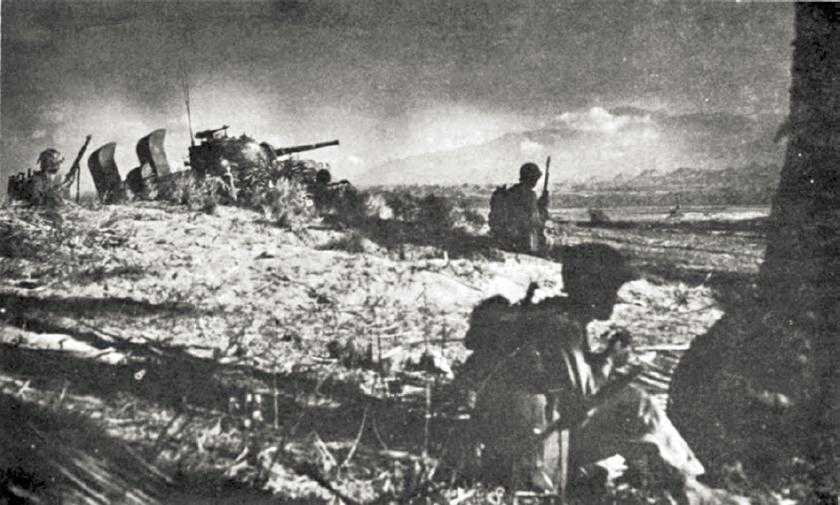
Dusk, 9 January
set up roadblocks along the coastal highway north of Alacan; one battalion remained in reserve near Mabilao.15
On 9 January the 103rd Infantry’s operations soon tended to become tactically distinct from those of the 169th and 172nd Infantry Regiments on the 43rd Division’s left, a condition that obtained for several days. The 103d’s initial objective was Hill 200, the high point of a two-mile-square group of low, gently sloping, grassy hills that lay almost ten miles southeast of the regiment’s assault beach, WHITE Beach 3. From points of vantage on the Hill 200 complex, Japanese observers could watch deployment of American forces over a large area south and southeast from the Sixth Army’s assault beaches. Moreover, the hills dominated the easiest and shortest approaches from the I Corps’ landing area to Route 3, the main highway running down the west side of the Central Plains to Manila.
Making an easy landing, the 103rd Infantry was through shattered San Fabian by 1030, having encountered no opposition. Small groups of Japanese delayed further advances toward the Hill 200 area, but by dusk leading elements of the 103rd had penetrated almost four miles inland. The regiment held for the night just north of San Jacinto, two miles east of the 1st Infantry’s concentration at Mangaldan.16
Although the I Corps’ assault units were ashore by dusk on S-day, there were important differences between the situation in its zone and that in the XIV Corps area. The I Corps’ penetration had not been as deep. The rising terrain in the sector of the 169th and 172nd Infantry Regiments, harassing fire from Japanese mortars and artillery, and delaying actions by small groups of Japanese across much of the corps front had combined to slow progress. Moreover, I Corps had no solid front. The 103rd Infantry, on the 43rd Division’s right, had no physical contact with the 6th Division, and within the 43rd Division area gaps existed between the flanks of the 103rd, 169th, and 172nd Infantry Regiments. In the open, heavily populated area over which the I Corps was operating so far, such gaps attained little significance – it would be extremely difficult, if not impossible, for the Japanese to launch surprise counterattacks over the terrain the I Corps had secured on S-day. But if the gaps continued to exist, or if they widened as the corps’ left flank units moved further into the hills on an axis of advance divergent from the center and right flank forces, then trouble might very well arise.
On 10 January the 6th Division – less the 63rd RCT, still in corps reserve – displaced generally south and south-southeast about four miles over flat, dry, open, and hot farm land, and at nightfall held a front of roughly seven miles, west to east. The division had had difficulties getting supplies forward during the day, a problem that, combined with a few minor skirmishes, had slowed progress. The 1st and 20th Infantry Regiments lost 2 men killed and 10 wounded on 10 January, and killed 15-20 Japanese. Again the advance of the division had not kept pace with the 37th Division on the XIV Corps’ left, and by dark on the 10th there was a 9-mile discrepancy of penetration along the corps boundary.
To the left of the 6th Division, the 103rd Infantry of the 43rd Division moved forward on 10 January on an ever-expanding front, the axes of advance of its flanks forming an angle of nearly 90 degrees. The 2nd Battalion engaged in a game of tag with a Japanese tractor-drawn 75-mm. artillery piece, which delayed the American unit from successive positions down the graveled road toward Manaoag at the southwestern corner of the Hill 200 group. The 103d’s supporting artillery destroyed the Japanese tractor during the afternoon, but the Japanese manhandled their gun into Manaoag as the American battalion halted west of the town for the night. The regiment’s other two battalions held west and northwest of the Hill 200 area. Again, as dark came the 103rd Infantry was out of contact with the 6th Division, to the right, and the 169th Infantry, to the left.
On the 11th the 103rd Infantry started up the open, grassy, western slopes of the Hill 200 complex and soon discovered that it faced stiff fighting before it could secure the area. To the right, the 6th Division’s 1st Infantry, which made patrol contact with the 103rd near Manaoag during the day, consolidated positions held the previous night. The 20th Infantry, against no opposition, again advanced over open farm land and secured about five miles of ground in a south-southeasterly direction across a front of nearly six miles. At dark the 20th Infantry was still about three miles behind the main body of the 129th Infantry, 37th Division, along the corps boundary.
The situation had developed far differently on 10 and 11 January in the zones of the 169th and 172nd Infantry Regiments, on the I Corps’ left. Troops of both regiments began looking deep into the face of death on 10 January, gaining a foretaste of the type of resistance that would hold up the 43rd Division for the next month. The division had had ample combat experience in the steaming jungles of the South Pacific and New Guinea, but the enervating heat, the steep-sided bare hills, and the fanatical opposition in the rising ground east and northeast of Lingayen Gulf was something else again. The worst of preassault imaginings about the Japanese in that sun-baked yet depressing hill country would come true all too soon.
Encountering resistance described as “heavy,”17 the 1st Battalion, 169th Infantry, behind close artillery and mortar support, fought throughout 10 January along the steep, grassy slopes of Hill 470 and finally seized the crest about 1730. The rest of the regiment, meanwhile, struck across the Bued River toward Hills 355 and 318, respectively two miles southeast and two and a half miles south of Hill 470. Treeless like the other hills in this portion of the 43rd Division’s area, Hills 318 and 355 provided the Japanese with excellent observation of the I Corps beaches, controlled the approaches to Route 3 in the country north of the 103rd Infantry’s sector, and also dominated the southern approach to grassy Mt. Alava, a 520-foot-high hill mass lying less than two miles east of Hill 470.
The 169th’s drive toward Hills 318 and 355 on 10 January halted near the Bued in the face of intensive artillery, mortar, and machine gun fire. On the 11th the regiment virtually surrounded Hill 318 but, despite the closest possible support from CVE-based aircraft, naval gunfire, and division artillery, was unable to dislodge the Japanese, who had tunneled themselves into the sides of the dirt and rock hill. The cave and tunnel defenses at Hill 318 typified those being found by all elements of the 43rd Division on 10 and 11 January, and the Japanese employed their holes not only for infantry protection but also for mortar and artillery emplacements. At Hill 318, specifically, the Japanese garrison consisted of an infantry company reinforced by mortars and a few pieces of artillery.
To the north on 10 and 11 January, the 172nd Infantry encountered similar defensive installations. The regiment cleared Hill 385 on the 10th and then struck toward Hills 351 and 580, along the southern part of the third ridge line inland from the beaches. Mopping-up operations at Hill 385, Japanese mortar and artillery fire, and danger from friendly artillery supporting the 169th Infantry at the southern end of the ridge, combined to slow the drive on Hill 351. On the 11th Japanese mortar and artillery fire all across the 172nd Infantry’s eastward-facing front waxed so intense that Maj. Gen. Leonard F. Wing decided to change the regiment’s direction of attack from east to north. He ordered the unit to strike toward Hills 351 and 580 from Hill 470, in the 169th’s zone, and from other points of vantage along the southern end of the third ridge line. Redeployment consumed much of the 11th, and the 172d’s right flank therefore gained little ground during the day.
On the division, corps, and army extreme left on 10 January the 1st Battalion, 172nd Infantry, advanced two miles up the graveled coast road and patrolled along the crest of the coastal ridge. Little opposition from Japanese infantry greeted this advance, but Japanese mortar and artillery fire harassed the battalion from the north and east. On the morning of the 11th the unit held its forward positions until relieved by the 158th RCT of Sixth Army Reserve.
The Beachhead Through S Plus 2
Committing the Sixth Army Reserve
As early as evening of 10 January, Sixth Army operations and intelligence officers had decided that the Sixth Army Reserve should be committed to the I Corps zone, as contemplated in the preassault plans. The situation at Lingayen Gulf was sufficiently disturbing to give pause to intelligence officers from infantry battalions on up through General MacArthur’s headquarters. All units had anticipated strong opposition, but as yet only the 169th and 172nd Infantry Regiments, on the far left, had encountered significant resistance, and it had begun to appear that these two units had uncovered a formal defense line. The Japanese had obviously withdrawn whatever strength they may once have deployed in the immediate assault area, but it was the consensus of intelligence officers that this withdrawal was a ruse. The Japanese were probably inviting the Sixth Army to overextend its lines until its flanks became vulnerable to counterattack.
Attention focused on the left as the probable point of Japanese attack. Allied air reconnaissance had substantiated guerrilla reports of Japanese troop movements and strong defenses to the north, northeast, and east of the I Corps beaches, and the opposition the 43rd Division had encountered provided additional confirmation. Indeed, as resistance increased along the 43rd Division front on 10 and 11 January, many intelligence officers began to feel that a Japanese counterattack might be imminent and that the Japanese were delaying the 43rd Division primarily to gain time to assemble forces for a large-scale counteroffensive.18
Other factors prompted commitment of the reserve in the I Corps zone, possibly the most important being Krueger’s desire for I Corps to advance toward the Army Beachhead Line at a pace more commensurate with that of XIV Corps. There were many reasons why I Corps had been unable to keep up. The corps had to cover far more ground to gain its objectives than did XIV – fully three-quarters of the terrain enclosed within the Army Beachhead Line initially lay within the I Corps’ zone. In addition, I Corps had to advance halfway around the compass – from north up Lingayen Gulf’s east shore around to the south along the corps boundary. In the smaller XIV Corps zone the advances had to cover only a quarter of the compass, from west to south, and, with no resistance on the west, XIV Corps could place emphasis on its advance south across a front approximately fifteen miles wide. The I Corps, by evening on 11 January, held an overextended front stretching
along an arc of some twenty-five miles from the gulf’s coast north of Alacan to Balingueo on the corps boundary.
The divergent advances of the I Corps divisions tended to create gaps along the front, gaps that would widen unless the corps received reinforcements. The existence of such gaps slowed progress, for all units had to patrol far to their flanks to maintain physical contact with friendly forces and to make sure that no concentrations of Japanese were bypassed. In this situation, the task of division reconnaissance troops and regimental intelligence and reconnaissance platoons was of special importance and significance.
The I Corps’ relatively slow progress southward began to hold up XIV Corps, for the latter’s left flank, exposed for almost nine miles during the night of 10- 11 January, was still exposed for about three miles at dusk on the 11th. Although the entire XIV Corps could apparently move south from its positions on the Army Beachhead Line and cross the Agno River without meeting serious opposition, the advance would increase the gap along the corps boundary. It would avail nothing for the 6th Division to proceed southward abreast of the XIV Corps’ left – such a move would create an exposed flank within I Corps. Either I Corps would have to be strengthened or XIV Corps would have to halt. For obvious reasons the latter solution could not be considered favorably by either General MacArthur or General Krueger.
On 11 January Maj. Gen. Innis P. Swift, the I Corps commander, had concluded that he would soon have to commit most of his corps reserve, the 63rd RCT, in the 43rd Division’s zone. The corps thereupon prepared to continue operations with but one battalion of the 63rd Infantry as a reserve. The 43rd Division had already committed its entire strength and the 6th Division’s remaining reserve was a battalion of the 20th Infantry.19 The margin of safety was too small, especially in view of a possible Japanese counterattack.
Accordingly, on the morning of 11 January, General Krueger sent the 158th RCT of the Sixth Army Reserve ashore on the I Corps’ left. Unloading just north of WHITE Beach 1, the RCT dispatched two infantry battalions up the coast road. One battalion relieved 172nd Infantry elements along the road and the other pushed north to within a mile of Rabon, three miles beyond Alacan, and dug in to block any Japanese attack down the coastal highway.20
The commitment of the 158th and 63rd RCTs on I Corps left seemed adequate to thwart immediate Japanese threats from the north or northeast. The 6th Division and the XIV Corps had not encountered sufficient opposition to warrant their immediate reinforcement. Therefore General Krueger decided to hold his other major reserve unit, the 25th Infantry Division, in reserve in the I Corps sector. The division began unloading on the 11th and started moving inland to an assembly area between the Agoi and Patalan Rivers behind the 43rd Division’s right flank.21
The remaining elements of Sixth Army Reserve – the 6th Ranger Infantry Battalion and the 13th Armored Group – also came ashore. The 6th Ranger Battalion, landing over BLUE Beaches on 10 January, moved on the 11th to the Dagupan area, where it began preparing a perimeter defense at a site selected for Sixth Army headquarters. The 13th Armored Group unloaded on the 11th and, less its 775th Tank Battalion, assembled at San Fabian. The 775th moved up the coast road to Alacan.22
The Situation: Evening S Plus 2
As viewed from the vantage points of MacArthur’s and Krueger’s headquarters, three strikingly significant facts had emerged by the time the Sixth Army’s reserve had begun to land. First, resistance to the initial penetrations had been surprisingly weak. Second, as expected, significant opposition was developing along the I Corps front from the north around to the southeast, and a threat of counterattack had arisen from the north and east. Third, further rapid advances would evidently overextend the Sixth Army’s lines, exposing flanks beyond the limits of calculated risk.
So far, casualties had been far lower than anticipated. Operations ashore to dusk on the 11th had cost the Sixth Army 55 men killed and about 185 wounded, the 43rd Division having lost the most men and the 37th Division the least. Most of the casualties had resulted from Japanese mortar and artillery fire rather than from close-in infantry action. Japanese casualties in ground operations had also been quite low; indications are that Sixth Army infantry had killed only 150-200 Japanese to evening on 11 January.23
At the end of the first three days of the campaign, then, the Sixth Army had seized a beachhead and, from a tactical point of view, had firmly established itself ashore. Plans for the next few days called for the XIV Corps to continue southward and secure crossings over the Agno River; the I Corps to continue to advance into what promised to be the center of Japanese resistance within the limits of the Army Beachhead Line. The major problem facing Sixth Army at dusk on 11 January was that of determining the nature, location, and extent of the opposition developing on the left. Where were the Japanese and what were they planning to do?