Chapter 9: Securing the Sixth Army’s Base Area
The Fight for the Routes 3-11 Junction
The 43rd Division, as it resumed its attack on 17 January to secure the junction of Routes 3 and 11, was well aware that strong Japanese forces remained within its zone of responsibility.(See Map II.) The division and its attached 158th and 63rd RCTs had good reason to believe that hard fighting was in store before they reached the junction and cleared the terrain to the Army Beachhead Line on Sixth Army’s northern flank.
The Situation
On 17 January, the 58th IMB, with its ample supporting artillery, was still responsible for holding the Damortis-Rosario road and the Routes 3-11 junction.1 The 23rd Division, commanded by Lt. Gen. Fukutaro Nishiyama, held the terrain along both sides of Route 3 south from the road junction to Pozorrubio. The division’s 1st Battalion, 64th Infantry, was on Hill 355, while the 3rd Battalion still held Mt. Alava.2 The 23rd Division’s 71st and 72nd Infantry Regiments defended the rising ground east of Route 3 between the junction and Pozorrubio. Here the terrain rose sharply to a ridge that begins at Hill 600, two miles north of Pozorrubio, and stretches northward six miles to Hill 1500, overlooking the junction. Hill 1500 seems to have been the responsibility of one of the 58th IMB’s independent infantry battalions; the rest of the ridge was defended by the 2nd and 3rd Battalions, 72nd Infantry,3 and the 3rd Battalion, 71st Infantry. The 72nd Infantry also had some strength so emplaced as to guard the entrance to the Arodogat River valley, east of the Hills 600-1500 ridge, in order to block that outflanking valley route.
The 2nd Battalion, 71st Infantry, holding defenses in the 6th Division’s zone, was cut off from the rest of the 23rd Division, which had as a reserve the 1st Battalion, 71st Infantry, located near the Routes 3-11 junction. Two battalions of the 19th Division were on their way south from Baguio to reinforce the 23rd Division, and the total strength available to General Nishiyama was probably
close to 13,000 men. General Wing, the 43rd Division’s commander, had well over twice that number at his disposal. He would need all this strength, for the advantages of terrain were still on the side of the Japanese.
The terrain in the 23rd Division’s zone was varied, within the framework of an area comprising generally rising ground. The ground in the vicinity of the Damortis-Rosario road has already been described; west of Route 3 in the region between the junction and Pozorrubio the slopes were bare, but fairly gentle; east of the highway the approaches to the crest of the Hills 600-1500 ridge line were bare and quite steep. Deep, sharp draws separated individual knobs throughout the area, some thick with scrub growth including bamboo thickets, others grass banked and offering little concealment. Throughout the area the Japanese had well-established, sometimes elaborate defenses. They had enlarged natural caves, dug new ones, and constructed tunnels to connect caves. Some artillery pieces were mounted on rails for easy withdrawal into caves; others were hidden in specially constructed nipa huts. Well-conceived camouflage and tactically sound emplacement of all weapons were hallmarks of the defense.
General Wing’s plan for securing the Routes 3-11 junction called for two converging attacks, both essentially frontal in nature. He did not feel he had the time, the strength, or the necessary knowledge of Japanese dispositions and the terrain to mount envelopments. He directed the 63rd, 158th, and 172nd Infantry Regiments to attack from the west along the Damortis-Rosario road and the 103rd and 169th Infantry Regiments to drive north astride Route 3 from Pozorrubio.4 The execution of this plan would involve the seizure of four separate objectives: the Damortis-Rosario road and the dominating terrain immediately north and south of that section of Route 3; the Hill 355-Mt. Alava complex south of Rosario and south-southwest of the Routes 3-11 junction; the Hills 600-1500 ridge line east of Route 3 from Pozorrubio north to the junction; and, finally, the junction and nearby dominating heights.
Mt. Alava and Hill 355
The 169th Infantry, 43rd Division, had moved to barrio Palacpalac, on Route 3 just north of Pozorrubio, for the purpose of seeking new routes of approach to Hill 355 and Mt. Alava.5 The regiment left one battalion on the south side of Hill 355 to contain the Japanese on that terrain feature. The rest of the unit spent much of 17 and 18 January preparing to launch an attack against Mt. Alava from the east and southeast, and on the 18th the 2nd Battalion moved north on Route 3 toward Sison, almost four miles beyond Palacpalac. About two miles south of Sison the unit branched off on a new section of Route 3 that bypassed Sison to the east and rejoined the old road half a mile northeast of the town. The Japanese, who had perfect observation all along the road, made no serious attempt to oppose the advance until late afternoon, when, as the American battalion secured the junction northeast of Sison, they began firing machine guns,
mortars, and artillery against the 169th’s unit. At dusk eight accompanying tanks of the 716th Tank Battalion were sent back to the Route 3 branching between Sison and Palacpalac because they seemed to be drawing the Japanese fire.
Beginning about 0500 on 19 January, a Japanese force composed of 64th Infantry units withdrawing from Mt. Alava (and possibly some 72nd Infantry troops cut off at Sison) struck the 2nd Battalion, 169th Infantry, from the southwest. By noon constant Japanese pressure, increasingly heavy Japanese artillery fire from which the American troops could find no protection, and a concomitant threat that the Japanese might cut Route 3 south of Sison, forced the battalion to withdraw along the flat, open land to the Route 3 fork where the tanks had bivouacked. As reassembled on 20 January, the 2nd Battalion had only 650 effectives left from a landing strength of over 1,000 men. Its combat casualties on 18 and 19 January had totaled approximately 35 men killed and 165 wounded; the broiling sun had taken an additional toll. However, the fighting on the 18th and 19th had not been wasted. The 64th Infantry, in order to keep open its line of communications, had practically denuded its Mt. Alava defenses and had lost nearly 400 men killed.
Mt. Alava was now wide open to attack by the 169th Infantry, and that regiment launched an assault on the 20th. By evening, the attacking forces had secured the bare crest of the mountain and the next day finished mopping up. The regiment turned its attention to bypassed Hill 355 and, employing two battalions, made slow and costly gains on the bare-sloped hill during 22 and 23 January. By late afternoon of the 24th the 169th had cleared most of the hill, and in the process had killed nearly 500 men of the 1st Battalion, 64th Infantry, and attached units. The 3rd Battalion, 103rd Infantry, then undertook the reduction of the last resistance at Hill 355 and Mt. Alava, and soon developed a quite sour view of its assignment:–
According to many infantrymen, a campaign for a ridge system is “strategically closed” when the enemy thereon, having lost his last “battleship” and possessing only isolated groups of three or four thousand men and a dozen or so artillery pieces, may no longer be expected to invade successfully the western half of the United States. Once the enemy is beaten to his knees to this extent, there remains only to “mop up.”6
At any rate, from 25 through 28 January the 103rd’s battalion killed nearly 150 more Japanese and captured or destroyed four 47-mm. antitank guns and seven 75-mm. and 105-mm. field artillery weapons at Hill 355. Three days later, having flushed a few hidden Japanese from Hill 355 and Mt. Alava, the battalion marched back to Pozorrubio to rejoin its parent unit. The first of the 43rd Division’s four separate battles was over.
The High Ground East of Route 3
The 103rd Infantry had secured Pozorrubio on 17 January against scattered resistance, thus opening a supply route to the 169th Infantry.7 On the 19th, its
elements further south having been relieved by the 25th Division, the 103rd began to attack Hill 600, the southern end of the ridge line lying east of Route 3 in the area between Pozorrubio and the Routes 3-11 junction. After frontal assaults that cost almost 100 men killed or wounded, the regiment secured a precarious foothold on the hot, grassy, open southern slopes of Hill 600 about dusk on 20 January, but was unable to gain more ground the next day on the bare terrain, which afforded no protection from Japanese fire. That continued frontal attack from the south, at least, would prove costly was made clear in a shocking manner on the morning of 22 January. An incautious grouping of officers and enlisted men in the open at a forward command post on Hill 600’s southern slopes brought down fifteen well-placed rounds of Japanese 75-mm. artillery fire. Within minutes 4 company commanders were killed and 2 others officers were wounded; 7 enlisted men were killed and 33 more were wounded, many of them key NCO’s. The 3rd Battalion, 103rd Infantry, had to withdraw from the hill to reorganize, and the 43rd Division revamped its plan of attack against the Hills 600-1500 ridge line.
General Wing now directed the 103rd Infantry to establish a line of departure along Route 3 and strike eastward against the northwestern slopes of Hill 600, simultaneously driving up the southwestern slopes of bare Hill 700, cresting nearly 2,000 yards north of the top of Hill 600. The regiment was also to secure Hill 800, lying about 1,200 yards across an open saddle northwest of Hill 700. The 169th Infantry, moving up to the 103d’s left (north), would seize Question Mark Hill, a little over 2,000 yards north of Hill 800, and the 3rd Battalion. 63rd Infantry, previously I Corps Reserve, was to clear Benchmark Hill, about 1,800 yards northwest of Question Mark. Once all these bare, steep-sloped hills were in American hands, the attacking forces would drive on to take Hill 1500, the southern crest of which lay 2,000 yards northwest of Benchmark Hill across the scrubwood draw of the Cauringan River.8
The new attack – essentially a frontal assault up the bare, western slopes of the Hills 600-1500 ridge line – started on the hot morning of 25 January. On the far left the 3rd Battalion, 63rd Infantry, secured the west side of Benchmark Hill at the cost of 8 men killed and 28 wounded. Then the battalion turned north across the Cauringan River to help the rest of the 63rd Infantry, which had just moved over from the Damortis-Rosario road sector, to clear Hill 1500. Meanwhile, the 169th Infantry had captured the open crest of Question Mark Hill, but left the eastern slopes in Japanese hands. On 27 January the 169th relieved elements of the 63rd Infantry still holding the western side of Benchmark Hill and then settled down to a
period of patrolling to hunt down Japanese stragglers and pinpoint defensive installations for air and artillery strikes.
To the south the 103rd Infantry (less the 3rd Battalion), on 25 January, had reached the open crest of Hill 600 but, finding its exposed position untenable until heights further north were cleared of Japanese, had had to withdraw. On the regiment’s left 82 men were killed or wounded in an abortive attempt to seize Hill 700 and Hill 600’s grassy northwestern slopes. Late in the afternoon patrols discovered that the Japanese had left undefended the saddle connecting Hills 700 and 800. That night one battalion of the 103rd employed the saddle as a route of approach to Hill 800, which the unit secured against a small, surprised group of Japanese.
About 1500 on 27 January Company E, 103rd Infantry, managed to reach the bare crest of Hill 700. Half an hour later all hell broke loose, to the accompaniment of a violent tropical cloudburst. Company F, 103rd Infantry, which had secured a foothold on the northwestern slopes of Hill 600, was hit by a strong Japanese counterattack; Japanese artillery lambasted the 2nd Battalion’s command post, disrupting communications, firing an ammunition dump, and inflicting 19 casualties; Japanese infantry struck Company E, which lost 15 men killed or wounded and had to abandon Hill 700. Throughout the following night small groups of Japanese struck intermittently at 103rd Infantry positions from Hill 600 to Hill 800. The next day the 103rd, like the 169th Infantry, settled down to a period of patrolling and consolidating. The regiment made one or two further efforts to take Hill 700, but neither it nor the Japanese of the 23rd Division were able to hold the hill’s narrow, exposed crest. In effect, the 43rd Division and the 23rd Division compromised on denying the hilltop to each other.
The 103rd and 169th Infantry Regiments had not accomplished their original mission of clearing the ridge from Hill 600 north to Question Mark Hill. On the other hand, they had secured much of the terrain immediately adjacent to Route 3 in their sectors and had largely succeeded in denying to the Japanese the southern two-thirds of the Hills 600-1500 ridge line, thereby protecting Route 3 from Pozorrubio north against direct and observed machine gun, mortar, and artillery fire. The task of eliminating mortar and artillery fire from more distant emplacements would devolve upon artillery and Army and Marine Corps aircraft. The two 43rd Division regiments would patrol to locate targets for these supporting arms, simultaneously guarding their own portions of the 43rd Division’s zone against Japanese surprise counterattack from the east.
The operations east of Route 3 had cost the 103rd and 169th Infantry Regiments dearly. Heat, fanatic Japanese resistance, and the necessity for attacking up open, steep slopes had taken a heavy toll until, by the end of January, each of the regiments’ infantry battalions was down to little more than one-half of effective strength. Casualties had not been exceptionally heavy on any one day – except, perhaps, for the 200 killed and wounded suffered by the 2nd Battalion, 169th Infantry, on 18 and 19 January – but the cumulative total was such that the two regiments were badly in need of rest and rehabilitation.
The Damortis-Rosario Road
Since one wing of the 43rd Division’s converging attack toward the Routes 3-11 junction failed to accomplish its mission, it fell to the 63rd, 158th, and 172nd Infantry Regiments to seize the junction, but before the three units could do so, it was necessary for them to secure the Damortis-Rosario road.9 By 17 January the 158th Infantry had driven approximately a mile and a quarter east along the road but then had been stopped at a defile through which the road passed at a point about 750 yards west of barrio Amlang. North of the defile a reinforced company of the 58th IMB defended an open, grassy ridge that stretched northward from the vicinity of Amlang two miles to the Cupang River. South of the road, on the middle of the three ridges that rose in steps inland from Lingayen Gulf’s eastern shore, a battalion of the 58th IMB had halted both the right flank of the 158th Infantry and the forward elements of the 63rd Infantry, which had been driving north athwart the middle ridge toward Amlang. The 58th IMB also had strong forces on high ground along both sides of Route 3 from Amlang southeast two miles to barrio Cataguintingan, near which the 172nd Infantry had reached the highway. The Japanese unit likewise held partially wooded high ground that lying north of the highway, dominated the town of Rosario and the flat, open farm land between Rosario and Cataguintingan. All three American regiments were more or less stalemated, and further progress by any one demanded a breakthrough by at least one other.
During the period 17-19 January the 158th Infantry’s leftmost units, gathering momentum behind close air and artillery support, cleared the ridge line north of Amlang against scattered but determined resistance. South of the road, on the middle ridge, both the 158th and the 63rd Infantry Regiments made negligible gains. Finally, late on the 18th, the 158th and 63rd made patrol contact about a mile south of Amlang and, coordinating plans, launched a concerted attack on the morning of 19 January against 58th IMB defenses along the northern section of the middle ridge. The last Japanese defenses collapsed on the 21st, and the 158th Infantry was then able to advance along Route 3, securing the road as far as a roadblock the 63rd Infantry had set up about 1,000 yards east of Amlang. The operations from 17 through 23 January (when the 158th reached the 63d’s roadblock) cost the two regiments roughly 50 men killed and 300 wounded. The 58th IMB lost nearly 650 men killed during the same period.
Route 3 continued southeastward from the 63d’s roadblock, and a poor road, hardly more than a trail, looped south from the roadblock to rejoin the main highway just west of Cataguintingan. On 23 January, pressed by General Wing to drive along Route 3 to the 172nd Infantry’s positions, the 158th Infantry dispatched troops and tanks eastward along both the highway and the loop road, but gained scarcely 500 yards. For the next two days the 158th’s progress demanded laborious, foot-by-foot advances over and up open hills and
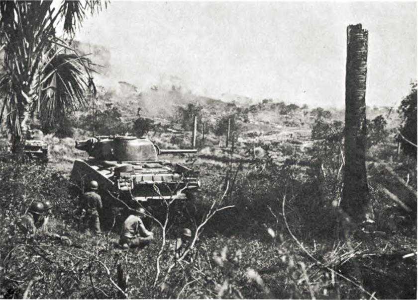
Medium tanks support 158th RCT near Damortis
ridges in the face of machine gun, mortar, and artillery fire, and it was not until 26 January that the regiment broke through to Cataguintingan. Now all that remained to clear the rest of the Damortis-Rosario road was to secure the flat, open two-mile stretch between Cataguintingan and Rosario, a task the 172nd Infantry had been about since 17 January.
In an exposed position on the open farm land near Cataguintingan, its supplies running low, the 172nd had spent 17 January patrolling and consolidating its positions. The following night a Japanese 155-mm. howitzer battalion that had been supporting the 58th IMB attempted to withdraw to Rosario through the 172nd Infantry’s roadblock. The Japanese unit lost five howitzers destroyed and over 100 men killed. However, a single round from a howitzer the Japanese had managed to get into action hit the command post and aid station of the 2nd Battalion, 172nd Infantry, killing the battalion commander, 2 other officers, and 14 enlisted men, and wounding 15 more officers and men.
On 18 January a company of the 172nd crossed Route 3 and seized positions on the southwestern slopes of Hill 600, two miles northeast of Cataguintingan and a mile northwest of Rosario. Using the fairly gentle southern slopes of the hill, which was partially covered by scrub growth, elements of the 172nd Infantry
then occupied a bare hill, also about 600 feet high, approximately 1,000 yards north of Rosario. From this hill the infantry, in cooperation with supporting artillery and aircraft, could control much of the Rosario area as well as the southern reaches of the Pugo Valley. This valley ran north into the mountains to connect with mountain trails leading to Baguio, and could be employed by the Japanese as a secondary avenue of retreat or reinforcement.
The 172nd Infantry marched on from the hill north of Rosario to Hill 606, a scrub-grown height half a mile northeast of the town and overlooking the stretch of Route 3 between Rosario and the Routes 3-11 junction. From a base of operations at Hill 606, patrols went into Rosario, finding the town mined, liberally booby-trapped, and defended by machine gunners and riflemen hidden in shattered buildings. The 172nd finally cleared Rosario on 28 January. Now the regiment could abandon its exposed, tortuous supply route that wound up the ridge to Cataguintingan and employ the two-lane, concrete-paved Route 3 inland from Damortis. The 43rd Division had completed the third of its four tasks.
The Routes 3-11 Junction
The final mission – securing the junction of Routes 3 and 11 a mile and a quarter east of Rosario – featured two regiments in a converging attack.10 The 172nd Infantry struck from the north and northwest; the 63rd Infantry drove in from the south and southeast. The key terrain feature in the 172nd Infantry’s zone was Hill 900, the scrub-grown peak of the hill mass of which Hill 606 formed a southwestern nose. Hill 900 lay about a mile and a half north of the junction, while the bare northern crest of Hill 1500, the 63rd Infantry’s key objective, was almost the same distance east of the junction and dropped steeply away on its western slopes to the Bued River. An old stretch of Route 3, lying about half a mile east of the main road, hugged the bottom of the Hill 1500 hill mass, the southern crest of which lay approximately half a mile south of the northern peak.
Hills 900 and 1500 were so located and their defenses were so arranged that they had to be attacked simultaneously; neither could be held until the other was also largely cleared of Japanese. Accordingly, the 63rd and 172nd Infantry Regiments launched a dual attack on the morning of 25 January. To avoid costly frontal assault, the 172nd sent its maneuver force northeast between Hills 600 and 606 and across the Pugo Valley to fall upon the Japanese rear on the northwestern shoulder of Hill 900. Achieving tactical surprise, the regiment cleared the northern and western slopes of the hill in time to dig in for the night before the Japanese struck back with two or three unsuccessful counterattacks. During the next three days, driving mainly against the rear of strong Japanese positions, the 172nd Infantry banged, clawed, bayonetted, and shot its way south through the scrub growth of Hill 900 against fanatically determined resistance. The last defenses fell on 29 January.
Meanwhile, the 63rd Infantry, attacking generally to the northeast, had sent
its 1st Battalion across the Bued River on 25 January to start a frontal assault up the open western slopes of Hill 1500. During the next two days the 2nd Battalion came up on the 1st’s right, and the 3rd Battalion (relieved at Benchmark Hill by the 169th Infantry) struck north across the Cauringan River and up Hill 1500’s bare southern slopes. The 63rd took the southern crest of the hill mass on 28 January, but left the northern crest and the eastern slopes in Japanese hands. On the 30th the 172nd Infantry took over the attack at Hill 1500, subsequently extending the hold to the northern peak.
By the 30th, then, American troops had cleared the Japanese from most important terrain dominating the Routes 3-11 junction. Patrols of the 172nd Infantry had reached the junction as early as 28 January but, since the area was devoid of cover, made no attempt to occupy it permanently. For the time being, it was enough that the high ground overlooking the junction was secure – the Japanese could no longer send forces down Route 11 from Baguio to execute a surprise attack against the Sixth Army’s left rear.
The final operations to gain control over the junction – from 25 through 30 January – had cost the 172nd Infantry about 30 men killed and 150 wounded, while the 63rd Infantry had lost about 40 men killed and 270 wounded. Perhaps as many as 1,000 Japanese, the majority of them members of the 58th IMB, gave up their lives in the junction area during the same period. The rough, tedious, three-week battle for the junction was over – the Sixth Army’s beachhead was secure against attack from the north and northeast.
Binalonan and San Manuel:
The I Corps Center
While the fight for the Routes 3-11 junction had been raging, I Corps center and right flank divisions had pushed steadily east and southeast to secure Sixth Army’s eastern flank and to provide protection to XIV Corps’ left rear. (Map III) The first job facing I Corps’ center division, the 25th, was to secure Route 3 from Pozorrubio south through Binalonan to Urdaneta, a total road distance of some ten miles. This done, the division would drive on eastward to a second objective line extending from San Felipe, two and a half miles east of Binalonan, to Bactad, three and a half miles east of Urdaneta, anchoring its left on the bare foothills of the Caraballo Range.11
The terrain over which the 25th Division was to advance was flat and open, characterized by dry and drying rice paddies, fields for other crops, and some carabao pasture land, none of which provided any cover or concealment except along stream beds. The stream beds and a few irrigation ditches constituted the only obstacles to free maneuver, but at this season of the year many of the smaller streams were dry, and easy fords were available across those that still carried water. A good network of all-weather roads existed in the division’s sector. Route 3 was a two-lane, macadam highway, while the east-west roads were two lanes wide and gravel surfaced. The only real transportation problem was whether the gravel roads
could stand up under the constant pounding of heavy military traffic.
The division’s first major objective was the road junction town of Binalonan, about midway between Pozorrubio and Urdaneta. The town was held by remnants of the Shigemi Detachment armored force that had made the abortive counterattack against elements of the 103rd Infantry, 43rd Division, during the night of 16-17 January.12 Under orders to move up to Binalonan from San Manuel, six miles to the east, the Shigemi Detachment had evidently started its displacement on 16 or 17 January, but the movement ceased on the 17th when General Shigemi learned that American troops were within a mile of Binalonan. Thus, as of 17 January, the Japanese garrison at Binalonan was composed of a company of the 2nd Mobile Infantry, 2nd Tank Division; eight or ten tanks of the 7th Tank Regiment; a few artillerymen manning two or three 75-mm. weapons; and some stragglers of the 2nd Battalion, 64th Infantry, from the Hill 200 area west of Binalonan. The total force probably numbered less than 350 troops.13
The defenses within Binalonan were of a hasty nature – trenches and dirt bunkers for the infantry, sandbagged emplacements under buildings, and earthen revetments behind which medium tanks were hidden hull down as pillboxes. With insufficient forces to man a perimeter all around, the garrison concentrated at the southern and eastern sides of Binalonan in order to hold the approaches to three bridges over the Tagumising River, which flowed southward past the eastern border of the town.14
On the morning of 17 January the 161st Infantry, on the 25th Division’s left, relieved troops of the 103rd Infantry holding a perimeter a mile west of Binalonan and immediately began patrolling toward the town.15 The 27th Infantry, on the division’s right, moved forward the same day from the vicinity of Manaoag and secured Route 3 from a point about a mile south of Binalonan to the 6th Division’s left at Urdaneta.
The regimental commander, Col. James L. Dalton II, delayed the 161st Infantry’s advance toward Binalonan for a couple of hours while he determined that a raid against his rear elements near Manaoag had no significance. Then, in the afternoon, his 3rd Battalion pushed into the northern half of Binalonan and cleared that section of the town before dark. Meanwhile, Japanese rifle and machine gun fire had stopped the 1st Battalion a block short of the Tagumising River in the southern half of town. About 1730 a lone Japanese tank ran across the battalion’s front, spraying the area with 47-mm. and machine gun fire before it was destroyed. Shortly thereafter, five more tanks began whipping through the streets in the southern and central sections of the town in a completely disorganized counterattack marked by wild firing in every direction by both sides in the affray. The 161st
Infantry finally destroyed the five tanks, and the night settled down to a “static fire fight” between the infantry elements.16
With the help of three mediums from the 716th Tank Battalion, the 161st completely cleared Binalonan by 1300 on 18 January. In and around the town the regiment had killed some 250 Japanese and had destroyed or captured 9 tanks, 2 75-mm. artillery weapons, 5 trucks, an artillery tractor, and large quantities of ammunition. The 161st lost 19 men killed, 66 wounded, and 3 trucks destroyed. For the 25th Division the cost had been relatively low considering the degree of control it had gained over roads leading to the east, southeast, and south. Certainly the cost would have been far greater had the main body of the Shigemi Detachment been in its proper position at Binalonan instead of six miles away at San Manuel.
After the capture of Binalonan General Swift, the I Corps commander, directed the 25th Division to move up to the San Felipe–Bactad line by evening on 20 January; secure crossings over the Agno River, which flowed generally southward in the division’s sector; and then reconnoiter eastward across the Agno up to ten miles beyond the San Felipe–Bactad line.17 The job was a big one, for the division’s front would extend in an arc nearly thirty miles long from Pozorrubio around to the 6th Division’s left and would have to be covered without help of the 35th RCT, which was still in army reserve. But Maj. Gen. Charles L. Mullins, Jr., the 25th’s commander, was not too worried. He had enough information to know that the 27th Infantry would encounter few Japanese, and he also knew that the only significant Japanese force still left west of the Agno River was the Shigemi Detachment at San Manuel. He had reasonably accurate information about the combat command’s strength and armament, but he did not know that General Shigemi had elected to stand to the last man at San Manuel.18
Dug in at San Manuel, the Shigemi Detachment was hardly an asset to Yamashita’s Shobu Group. It guarded but one approach to the Villa Verde Trail route into the group’s final redoubt – a poor road running east from San Manuel to San Nicolas and crossing the Agno River via a long, rocky ford that was nearly impassable to wheeled vehicles. A good gravel road ran south from San Manuel and connected with other roads leading toward the entrance to the Villa Verde Trail and toward San Jose as well. These roads south of San Manuel were well connected with Urdaneta and other towns in the 6th and 25th Divisions’ sectors. The Shigemi Detachment could not withdraw east, for it had already decided that the long ford and the Villa Verde Trail were impassable for its armor, artillery, and trucks; there were no roads to the north; withdrawal to the west was already impossible; and the escape route to the south was cut on 19 January when the 27th Infantry, 25th Division, moved into Asingan, four miles south of San Manuel.
Not knowing that General Shigemi had made up his mind to fight to the death at San Manuel, General Mullins
considered the Shigemi Detachment a strong threat to his left that he would have to eliminate before the 25th Division could thrust across the Agno. Accordingly, he directed the 161st Infantry to destroy the Shigemi Detachment. The ensuing engagement, given General Shigemi’s plan to hold fast, had little significance in the broad scope of the Luzon Campaign. However, it foreshadowed subsequent encounters with Japanese armor and provides a neat picture of 25th Division tactical maneuver against armor employed as a purely stationary defensive weapon.
San Manuel lies just off the southeastern nose of a bare, steep-sided ridge that, rising to a height of 850 feet less than a mile north of town, leads northward into the Caraballo Mountains.19 Along the west side of the ridge lies the Aboredo River and its steep-banked valley, stretching north to connect with rough mountain trails leading toward Baguio. East of the ridge is a lesser stream and a dirt road that heads northward five miles to the Agno River near the point where that stream debouches from its mountain gorges to begin its majestic sweep across the Central Plains.
The stream east of the ridge runs on south through a steep draw on the eastern side of San Manuel. A small drainage ditch runs around the nose of the ridge on the north side of town, the southern and western sides of which are lined with deep, broad drainage and irrigation ditches. Dense bamboo thickets, some of which included large trees, grow along the outskirts of the town. The only fairly open approach is on the southwest, where the main road from Binalonan comes in past a small cemetery.
The Japanese garrison numbered over a thousand men, with the rifle elements concentrated in the understrength 1st Battalion, 2nd Mobile Infantry. There were 40 medium and 5 light tanks of the 7th Tank Regiment, about 15 75-mm. and 105-mm. artillery pieces from the 2nd Mobile Artillery, a few 47-mm. antitank guns, at least 25 machine guns, and 15 or more light mortars. The defense was centered on tanks in earthen revetments. There were 75 revetted emplacements in San Manuel, each ringed with rifle pits and at least one machine gun position. Initially, tanks occupied 25 to 30 of the revetments, while Shigemi held out 10 to 15 tanks as a mobile reserve. Tanks and infantry could move rapidly from one revetted strongpoint to another. The Japanese oriented the defenses principally against attack from the west, southwest, and south, but they did not neglect the other approaches entirely and disposed their weapons in depth for all-around defense.
Considering the tactical importance of the ridge north of town to both attacker and defender, it is almost incredible that the Shigemi Detachment stationed only a platoon of infantry there. The 161st Infantry made no such mistake. The regiment had to seize the ridge to secure its northern flank, to block the Aboredo
Valley as a route of Japanese reinforcement or withdrawal, and to gain an excellent jump-off point for the attack. For the rest, Colonel Dalton’s plan for the reduction of San Manuel called for a converging attack. The 2nd Battalion was to make the main effort, striking from the north; the 1st Battalion, in support, would move in from the west and southwest from the south side of the road to Binalonan. The 3rd Battalion was at this time in corps reserve, but the 161st Infantry was strengthened by a reinforced company of the 716th Tank Battalion and Company D, 98th Chemical Battalion, with its 4.2-inch mortars.
By evening on 23 January, at the cost of 3 men killed and 5 wounded, the 161st had secured the southern slopes of the bare ridge north of San Manuel and had set up trail blocks in the Aboredo Valley. The entire 2nd Battalion then deployed along a line of departure northwest of the town in preparation for a dawn attack on the 24th. The 1st Battalion, coming forward along the road from Binalonan, halted at the last cover west of San Manuel.
On 24 January the 1st Battalion’s secondary attack started first, behind a fifteen-minute artillery and mortar preparation. The effort failed. Supporting tanks could not cross a tree-lined drainage ditch on the southwest side of town, and Japanese 47-mm. fire destroyed one tank and temporarily disabled four others. A sixth tank was immobilized when it attempted to hurdle the ditch. Pinned down, partially in the open, hot fields, the 1st Battalion lost 6 men killed and 55 wounded during the day; the supporting tank company lost another 2 men killed and 8 wounded. Late in the afternoon both the infantry and the tanks withdrew westward to covered positions.
The first attacks by the 2nd Battalion met with no greater success. Company F, striking down the ridge, advanced fifty yards into San Manuel, but a Japanese counterattack, spearheaded by three tanks, drove the company out of town at midmorning. The 2nd Battalion launched another attack shortly after 1730, with Cannon Company M7’s and Antitank Company 37-mm. guns in close support. At dark the battalion had a tenuous hold on the northern part of San Manuel, and its supporting weapons had knocked out five Japanese tanks and reduced the volume of machine gun and rifle fire that had been slowing the attack.
During 25 and 26 January the 2nd Battalion, supported by tanks transferred from the 1st Battalion’s sector and by elements of both the 1st and the 3rd Battalion, inched its way southward through the town, gaining two or three blocks across a front six blocks wide. Company B, attached, moved around to the 2nd Battalion’s left (east) flank and blocked the bridge over the draw on the east side of San Manuel, thereby cutting the last route by which the Japanese could evacuate their tanks. Early on the morning of the 27th all of the 1st Battalion swung around to the 2nd’s left, and at mid-morning the two battalions launched a coordinated attack southward behind close support from two battalions of 105-mm. howitzers. By dusk, after a bloody day’s fighting at close quarters, the two battalions were abreast along the north side of the main road through town.
About 0100 on the 28th the Japanese launched a counterattack against the regimental center with 13 tanks in waves of 3 or 4 each, Japanese infantry
following. The 161st knocked out 10 tanks; the other 3 and infantry survivors then withdrew into the southeastern corner of the town. Before dawn most of the Japanese left in San Manuel scrambled across the draw on the east side of town and fled, but not before launching a final counterattack to cover their escape. At 0930 the 161st Infantry’s two battalions resumed the drive southward through the town, and by 1330 San Manuel was clear.
In a heroic but tactically unimportant stand the Shigemi Detachment had virtually fulfilled its self-imposed desire for annihilation in place. The detachment had lost 750 men killed; all its tanks, artillery, trucks, machine guns, and mortars had been either captured or destroyed. Probably no more than 250 troops escaped, and many of them were unarmed and wounded. The 161st Infantry and attached units had lost approximately 60 men killed and 200 wounded; the 716th Tank Battalion lost 3 tanks.
The necessity for the bloody assault on San Manuel is, perhaps, open to question. Colonel Dalton stated:–
The town could at any time have been by-passed to the south and blocked off. . . . no noticeable effort was made [by the Japanese] to hold the eastern exit of town, so that after three days’ fighting [American] traffic could have passed unimpeded through the north side of town and on to San Nicolas. Two more days were required to clear the southern half of town.20
Yet common sense lent ample support to General Mullins’ decision to eliminate the Shigemi Detachment before sending his division on to execute all the missions assigned it by I Corps. Mullins did not know that the Shigemi Detachment intended to hold in place – to him the combat command clearly possessed a counterattack capability and therefore constituted a threat to his left. As matters stood at 1330 on 28 January, the 25th Division could advance eastward to cross the Agno River in its sector without having to worry about the security of its left flank.
Advancing the I Corps Right
The chief responsibility for protecting XIV Corps’ left rear during the early stages of the corps drive south through the Central Plains of Luzon devolved upon the 6th Infantry Division, I Corps’ rightmost unit. The division’s missions were to clear the remaining terrain to the Army Beachhead Line in its sector; drive south and east to an objective line stretching from Bactad, on the 25th Division’s right, south almost fifteen miles to Cuyapo; seize and secure crossings over the Agno River in its zone; and reconnoiter south and southwest toward Guimba and Victoria to establish contact with the 37th Division’s left. The 6th Division would start to execute the missions understrength, for its 63rd RCT remained under 43rd Division control for the duration of the fight for the Routes 3-11 junction.21
By 17 January, when the 6th Division started forward from the Malasiqui–Manaoag line it had held since the 14th, division patrols had discovered a pocket
of Japanese in the Cabaruan Hills, lying athwart a secondary gravel-surfaced road connecting Malasiqui with Villasis, on the Agno River six miles south of Urdaneta. The division also had reason to believe that the Japanese held Urdaneta and controlled the gravel road that led from Urdaneta three and a half miles east to Bactad. Indications were that strong Japanese forces might likewise be encountered at Villasis, holding the Route 3 bridge across the Agno, and at Carmen and Rosales, just across the river from Villasis.
The Cabaruan Hills
Crossed by the Army Beachhead Line, the Cabaruan Hills formed a low barrier approximately four miles square that dominated the approaches to Route 3 and the Agno River east and south of the 6th Division. With few heights over 200 feet, the hills were covered with bamboo thickets, scattered palms, a few patches of scrub growth, and open fields. Shallow valleys, either grassy or cultivated, separated individual knolls and afforded little opportunity for covered or concealed approach to Japanese defenses.22
Originally, the Cabaruan Hills had been the southern anchor of the 23rd Division’s outer defense line. The garrison, known as the Omori Detachment, was built around the 2nd Battalion, 71st Infantry, and numbered about 1,500 troops. Reinforcing units included a battery of 75-mm. artillery, two or three medium tanks, various service units, and the Gun Company, 71st Infantry. Defenses, under preparation for some time, were concentrated in the northwestern section of the hills in an area immediately west of the town of Cabaruan which lay at the north-central edge of the hills.23
As had been the case with the Shigemi Detachment, it might have been possible to bypass the Omori Detachment and contain it with minimum forces. Maj. Gen. Edwin D. Patrick, the 6th Division commander, seems to have had such a plan in mind.24 He apparently hoped that a hard attack by the 20th Infantry, on his division’s right, could overcome most of the Japanese resistance in two or three days. Then he could leave a single battalion behind to mop up while the rest of the division pushed on to the Bactad–Cuyapo objective line.25
In preparation for its attack, the 20th Infantry had slowly moved troops into the hills until, at dawn on the 17th, the 1st Battalion was in the center of the hills, where a north-south trail crossed the road to Villasis; the 2nd Battalion, which was to make the main effort, was at barrio Lunec, at the hills’ northwestern corner; the 3rd Battalion was in reserve off the west-central edge of the terrain complex. By evening on the 18th, the 2nd Battalion had reached a low ridge line about 2,500 yards west of the town of Cabaruan and had determined that the center of resistance lay in a U-shaped group of knolls and ridges 1,000 to 1,500 yards to its front. While the 20th Infantry clearly had not yet
reached the main defenses, the attack had so far gone easier than anticipated, and General Patrick expected that the regiment could complete its task by dark on the 19th.26 It had better, for I Corps had directed the 6th Division to get to the Bactad-Cuyapo line by dusk on the 20th.27
Despite a setback during the afternoon, operations on 19 January seemed to meet with success. By evening of that day over 500 Japanese had been killed throughout the hills, and the 20th Infantry estimated that not more than 300 were left in the northwest pocket. Since it appeared that little further effort would be required to overcome the last opposition, General Patrick directed the 20th Infantry to pull two of its battalions out of the hills. The remainder of the regiment, reinforced by a company of 4.2-inch mortars and one of medium tanks from the 44th Tank Battalion, would finish mopping up.
Probing slowly through the roughest ground in the Cabaruan Hills on 20 and 21 January, the 20th Infantry’s reinforced battalion jumped off in the morning of the 22nd in what was expected to be the last attack, its way paved by an especially heavy artillery and air bombardment. But from the start, operations on 22 January did not go as planned. The air strike, conducted by Fifth Air Force A-20’s was four hours late, subjecting the infantry to “a nerve racking wait,”28 and did not include requested napalm. Air and artillery concentrations were, however, well placed, and it seemed improbable to the waiting infantry that many Japanese could have lived through them. A combined tank-infantry assault began about 1230 and proceeded slowly but steadily for almost two hours. Then the attackers were stopped cold by a tremendous burst of rifle, machine gun, and light artillery fire from the very hillsides that had received the weight of the bombardments. Company E, in the lead, fell back; Company G’s officers were all either killed or wounded, and the company was temporarily scattered; Company F was pinned in place; two supporting tanks were knocked out; casualties mounted quickly to 10 men killed and 35 wounded.
As early as 20 January the 20th Infantry had estimated that one reinforced battalion was too weak for the task at hand and had asked that another battalion be committed. Col. Washington M. Ives, Jr., the regimental commander, requested that he be given at least an additional rifle company and followed his request with a report that 600 Japanese remained in the Cabaruan Hills.29 Greatly perturbed by the implied delay to a general advance south and east that the 20th Infantry’s request and estimate brought up, General Patrick directed the 1st Infantry to send one battalion to reinforce Colonel Ives, a redeployment made possible because the 1st Infantry had encountered only scattered resistance in its sector.30
On 24 January the reorganized 2nd Battalion of the 20th Infantry held in place as the newly arrived battalion of the 1st Infantry took up the attack. The
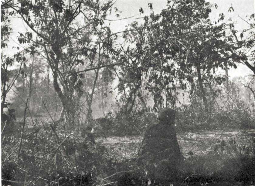
Watching and waiting in Cabaruan Hills
1st Infantry’s battalion made limited gains, but had closed with the main defenses by dark. Prospects for quick success seemed so much brighter that the 20th Infantry’s elements were withdrawn from the hills.
General Krueger had by now taken a direct interest in the fight and on the 24th directed General Swift, I Corps commander, “to promptly eliminate” the remaining opposition in the Cabaruan Hills lest the 6th Division and, concomitantly, XIV Corps, be further delayed.31 General Swift relayed the message to General Patrick, who reported to the corps commander that the 1st Infantry could probably clear up the last resistance in another day. There were only a hundred Japanese left alive in the last pocket, Patrick estimated, and there seemed no necessity to commit additional troops.32
The 1st Infantry’s battalion attacked again on the 25th but by nightfall had gained only 300 yards of new ground against determined resistance. Nevertheless,
about 1830 General Patrick reported to General Swift that organized resistance in the Cabaruan Hills was over, an estimate with which the 1st Infantry did not agree. Instead, the regiment believed that 150 to 200 Japanese still held strong positions and requested that before resuming the attack its assault battalion be reinforced with ten to twelve flame thrower teams.33 Action on 26 January proved the 1st Infantry right. During the morning the battalion gained only 150 yards at the cost of 12 men killed, 12 wounded, and a tank destroyed. General Patrick thereupon directed the regiment to move another battalion into the hills for a coordinated attack on the 27th.34
The two-battalion attack was successful and by 1600 on 28 January the 1st Infantry had overcome all resistance in the Cabaruan Hills. In the last two days, the 1st Infantry’s battalion lost approximately 20 men killed and 50 wounded while killing an additional 225 Japanese. A final summation disclosed that over 1,400 Japanese had been killed in the hills between 17 and 28 January. The 6th Division’s units engaged there had lost about 80 men killed and nearly 200 wounded. The Omori Detachment had indeed fought to the death, but while it had done so the bulk of the 6th Division had swept around and beyond it.
Urdaneta to Cuyapo
On 17 January, while the 20th Infantry started closing in on the Omori Detachment, the 1st Infantry began to advance toward Urdaneta from the west and northwest.35 At Urdaneta a small outpost of the Shigemi Detachment put up a fight strikingly similar to that in which the 161st Infantry, 25th Division, had engaged at Binalonan. The 1st Infantry lost about 5 men killed and 15 wounded at Urdaneta; the Shigemi Detachment lost over 100 men killed and another 9 tanks destroyed.
Relieved at Urdaneta by elements of the 25th Division on 19 January, the 1st Infantry sped southward along Route 3 toward Villasis and the Agno River, six miles distant. That day the regiment occupied Villasis against no resistance and moved across the river to secure Carmen. It also took Rosales, on Route 8 about three miles east of Carmen, again against no opposition. On the 20th, a battalion of the 1st Infantry continued eastward along gravel-surfaced Route 8 another three miles to Balungao, which guerrillas already occupied. Balungao was located on the Bactad–Cuyapo objective line about midway between the latter two towns. Less elements sent back to the Cabaruan Hills, the 1st Infantry held the Rosales–Villasis–Balungao area until 28 January.
Meanwhile, the battalions of the 20th Infantry, as they were released from the Cabaruan Hills, moved south and southeast through Villasis to Cuyapo, taking the latter town on 20 January. The 6th Division had thus secured its portion of the I Corps’ objective line and was ready to go on to the corps reconnaissance line, which extended from Victoria, on the I-XIV boundary fourteen miles south of Cuyapo, northeast about eight miles to Guimba, in turn some ten miles
southeast of Cuyapo. The 6th Reconnaissance Troop had reached Guimba on 20 January and had made contact with XIV Corps patrols at Victoria the same day, but until the resistance in the Cabaruan Hills was cleaned up, the 6th Division was unable to move stronger forces south and southeast from Cuyapo.
The Achievements Analyzed
For the Japanese forces holding positions along the Sixth Army’s left flank, the defense as conducted since 9 January had not been without its bright spots. The 23rd Division and 58th IMB had held the Routes 3-11 junction against heavy odds for almost two weeks, and in so doing had inflicted many casualties upon I Corps. Despite the loss of the entrance to Route 11, Baguio – the southwestern anchor of the Shobu Group’s final redoubt – seemed secure for some time to come, and Sixth Army had not yet gained contact with the strongest defense forces holding in front of San Jose – gateway to the approaches to the group’s southeastern anchor.
On the other hand, Japanese losses in men and matériel had been staggering. The 23rd Division was little more than half its original strength; nearly two-thirds of the 58th IMB and attached artillery were casualties. The regiments of the 23rd Division would fight again, but their ranks would be filled by ill-trained replacements or would be brought partially up to strength by the attachment of third-class provisional units. Of even greater significance was the loss of most of the 23rd Division and 58th IMB artillery, together with numerous trucks and large stores of ammunition and other supplies. In fact the units’ losses had forced Yamashita to the conclusion that a protracted attempt to hold the Routes 3-11 junction would have been futile. On or about 23 January he had, accordingly, instructed the 23rd Division to make preparations to withdraw further up Route 11. The withdrawal was not well under way by 28 January, but the beginnings of the retreat had probably rendered easier the tasks of the reinforced 43rd Division on the I Corps left.36
To the south the picture was not so bright for the Japanese. By their fight to the death in place, the Omori and Shigemi Detachments had deprived the Shobu Group of a reinforced infantry battalion and an armored combat command. The slight delay the two units imposed upon I Corps was hardly commensurate with the loss of first-line troops and valuable combat equipment that could have been used to better advantage elsewhere. The fantastic stands of both detachments are illustrative of a sort of tour de force to which the Japanese Army seemed peculiarly addicted during World War II, but neither stand had much significance.
It is true that during the time the 6th and 25th Divisions were fighting against the Omori and Shigemi Detachments, the Shobu Group was able to redeploy forces further east for the more effective defense of San Jose,37 but the opportunity for the redeployment was only an incidental and accidental result of the Omori and Shigemi Detachment stands. Theoretically, the 6th and 25th Divisions
could have bypassed and contained the two Japanese units, but the Japanese had held positions from which they could threaten the eastern crossings of the Agno, and Sixth Army could not know that the fighting at San Manuel and in the Cabaruan Hills had been undertaken to overcome dangers more imaginary than real. Actually, elements of both U.S. divisions had bypassed the Japanese units, but neither division could move far beyond the Agno lest its rear become exposed to counterattack from the north. First, the 43rd Division had to gain control of the Routes 3-11 junction, and it actually had been the defense offered by the 23rd Division and the 58th IMB that had permitted Shobu Group to realign forces in front of San Jose.
Convinced earlier that Yamashita could endanger the Sixth Army’s base area, the safety of which was essential until the Manila Bay region fell, Krueger had ample reason to believe that the 43rd Division’s success had secured the army’s left and rear against the Japanese threat. The army’s base area was safe. The gains achieved by the 6th and 25th Divisions had added to this security, but the most decisive action had been that of the 43rd Division and its two attached RCTs.