Chapter 21: The Reduction of the Shimbu Group; Phase I: Turning the Shimbu Left
Plans
XIV Corps Plan of Attack
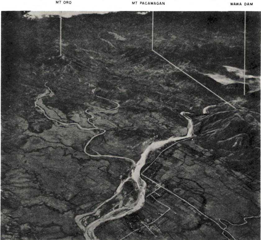
Although XIV Corps launched its attack against the Shimbu Group primarily to assure the security of the Manila Bay area, the corps knew that the attainment of its goal was but a means to an end – the rehabilitation and development of the bay region.1 Of major significance in all plans of development was the fact that the Shimbu Group controlled extremely important installations of the metropolitan water supply system. On the Angat River nearly twenty-five miles northeast of Manila, the Japanese held Ipo Dam, which provided the city with a third of its water. (See Map V.) They also possessed a good part of an aqueduct through which the waters of the Angat flowed from Ipo Dam to Novaliches Reservoir, ten miles northeast of Manila. Without Ipo Dam’s water supply, Novaliches Reservoir was capable of meeting only half the city’s water requirements. The headquarters of Sixth Army and XIV Corps also believed that the smaller Wawa Dam, on the Marikina River fifteen miles northeast of Manila, formed an integral part of the metropolitan water system. Actually, Wawa Dam had been abandoned as a source of water for Manila upon the completion of the Ipo and Novaliches installations in 1938, and since then the smaller diversion dam had principally served irrigation projects in the Marikina Valley. However, the old pipeline connection to the city water system still existed and presumably could be used if certain repair materials were available. Even reconnected, the Wawa Dam source could provide only 15 percent of Manila’s water requirements.
Basing his plans partially upon the erroneous information concerning the Manila water sources and partially upon equally erroneous information on the strength and deployment of the Shimbu Group, Krueger directed XIV Corps to seize first Wawa Dam and its pipeline connections and then secure Ipo Dam and associated installations. General Griswold, commanding the XIV Corps, ordered the 2nd Cavalry Brigade and the 6th Infantry Division to launch offensives to these ends by 20 February. He directed the two units to strike eastward from the Marikina River to a 28-mile-long
objective line. The first north-south part of the line, 10 miles long, connected the two dams; another 10 miles extended the line south from Wawa Dam to Antipolo in the southwestern foothills of the Sierra Madre; the last section of the line bent southwest to Tagig, at the northwestern corner of Laguna de Bay and 7 miles southeast of Manila. The 6th Division was responsible for the seizure of the two dams; the 2nd Cavalry Brigade was to secure the Antipolo-Tagig area. The boundary between the two units lay roughly four miles south of Wawa Dam.
In accordance with this concept General Patrick, commanding the 6th Division, directed the 20th Infantry, on his right, to strike directly east toward Wawa Dam. The 112th Cavalry RCT, now attached to the 6th Division, would continue to protect the XIV Corps line of communications south along Route 5 and from its positions on the left of the 6th Division would patrol toward Ipo Dam. The division’s 63rd Infantry, going into the line between the 112th Cavalry and the 20th Infantry, would patrol toward Ipo Dam with its left, meanwhile mounting an attack toward Wawa Dam with its right in concert with the 20th Infantry.2 On the Antipolo-Tagig front, the 2nd Cavalry Brigade would send its 7th Cavalry against Antipolo while the 8th Cavalry, on the right, would secure the Antipolo-Tagig section of the corps’ objective line.3 Both the 6th Division and the 2nd Cavalry Brigade would jump off from a line of departure along the west bank of the Marikina River, flowing generally south through a wide valley from Montalban, three miles west of Wawa Dam, to a junction with the Pasig River near Tagig.
Shimbu Group Plans and Dispositions
The Sixth Army’s estimate that the Shimbu Group had about 20,000 troops in the high ground east and northeast of Manila was low.4 With a total of some 50,000 troops, Shimbu Group had deployed about 30,000 men in the area of immediate interest to XIV Corps.5 The 30,000 were firmly entrenched in excellent defensive terrain and well-prepared positions into which General Yokoyama, Shimbu Group commander, had directed his men to withdraw after the collapse of the mid-February counterattack toward Manila.6
Anchored on high, rugged terrain 2 miles north of Ipo Dam, the northern section of the Shimbu Group’s westernmost defenses extended south-southeast some 9 miles to Mt. Oro, 4 miles north of Wawa Dam. The line then turned south (and slightly west) to Mt. Pacawagan, lying on the south bank of the Marikina and dominating an east-west stretch of that river between Wawa Dam and Montalban. The defenses continued south across the steep, grassy, western slopes of the Sierra Madre foothills to a point about a mile and a half west of Antipolo. At Antipolo the line swung southeast over broken, open ground to the valley of the Morong River, flowing into Laguna de Bay seven miles southeast of Antipolo. From Mt. Oro south, the defenses provided the Japanese with perfect observation of the open, heavily cultivated Marikina Valley. The defenses on the Ipo Dam front, also located on rising, broken ground, controlled the approaches to the dam. All defenses were organized in considerable depth, west to east, but lacked good north-south lines of supply and reinforcement.
The forces deployed along the Shimbu Group’s defensive line were a heterogeneous mass of recently formed provisional organizations, many of them built around a nucleus of 8th and 105th Division units.7 On the Ipo Dam front was the 9,000-man Kawashima Force. The principal combat strength of this force was organized into two provisional infantry regiments, while three provisional infantry battalions and about two battalions of artillery operated directly under force headquarters. The only “regular” infantry unit was the 358th Independent Infantry Battalion of the 105th Division, itself formed in 1944 from miscellaneous garrison units.
South of the Kawashima Force, the 12,000-man Kobayashi Force extended the defenses to a point about midway between Wawa Dam and Antipolo. The Kobayashi Force included 3 provisional infantry regiments, 3 provisional infantry battalions under force headquarters control, 1 artillery battalion, 2 heavy (150-mm.) mortar battalions, a rocket battalion, and other miscellaneous combat and service units. The only “regular” organizations were 5 infantry companies assembled from 3 different divisions.
The next unit to the south was the Noguchi Force, with some 9,000 men.8 This force included two provisional infantry regiments, four infantry battalions under force headquarters control, and various artillery and mortar units. The “regulars” were four understrength independent infantry battalions of the 105th Division. The force’s line extended from its boundary with the Kobayashi Force, north of Antipolo, southeast to Pililla, on the north-central shore of Laguna de Bay about twelve miles from Antipolo.
At Pililla the Noguchi Force maintained contact with the Kogure Detachment, a provisional infantry regiment of some 2,250 men built around the suicide boat squadrons and base battalions of the 1st Surface Raiding Base Force. The detachment’s mission was to protect the Shimbu Group rear against attack from Laguna de Bay, the Bicol
Northern Section of Marikina Valley
Peninsula, or Lamon Bay on Luzon’s east coast. The detachment had a few pieces of artillery under its control along the shore of Lamon Bay. Cooperating with the detachment for the defense of Lamon Bay were about 3,000 naval troops, most of whom had escaped from Manila. Some 7,000 other naval personnel, mainly noncombat troops and civilian employees and their families, were holed up along the valley of the Bosoboso River, southeast of Wawa Dam.
Shimbu Group Reserve, numbering 5,000 troops, included the 31st Infantry of the 8th Division, less its 3rd Battalion but otherwise reinforced; the reinforced 3rd Battalion of the 17th Infantry, 8th Division; the 2nd Battalion, reinforced, of the 26th Independent Mixed Regiment; the 8th Reconnaissance Regiment
of the 8th Division; and two provisional infantry battalions – all in all, the cream of General Yokoyama’s ground combat strength. Another 2,750 men – three artillery battalions and elements of the various 8th Division service units – also operated under the direct control of Shimbu Group headquarters. Yokoyama concentrated most of the Shimbu Group Reserve in the Bosoboso Valley behind the Kobayashi and Noguchi Forces. All the reserve units could move rapidly to threatened sections of the lines held by these two forces, but would need three or four days to reach the Kawashima Force front. From the deployment of his reserve, it appears that Yokoyama correctly guessed that XIV Corps’ initial attacks would be directed against his left and center.
Most of the Shimbu Group supplies were concentrated in the Ipo and Wawa Dam areas, although some supplies, including those belonging to naval forces, were stored along the Bosoboso Valley. Anticipating that he would soon lose control of the road net west of the Marikina, Yokoyama had directed the construction of a north-south main supply route behind his front. The southern section was a truck road, built over an old horse trail, running generally northeast six miles from Antipolo to barrio New Bosoboso, on the Bosoboso River eight miles southeast of Wawa Dam. Existing trails along the Bosoboso to a point near the dam were also improved for truck traffic, but from this point on a narrow trail, negotiable only by hand-carrying parties, led through the trackless terrain separating Ipo and Wawa Dams. Cutting some trails north and south through the rough country lying between the Bosoboso and Marikina Rivers, the Shimbu Group made a minimum provision for front-line supply and reinforcement movements between the Noguchi and Kobayashi Forces. However, the lack of an adequate north-south line of communication in the region remained a weakness of Shimbu Group defenses.
As of late February the Kawashima and Kobayashi Forces had plenty of supplies, but the Noguchi Force supply problem was acute from the first, much of that unit having recently and hurriedly withdrawn from the Bicol Peninsula. The Shimbu Group expected to supplement its food supplies from rich agricultural areas along the northern shores of Laguna de Bay, the Lamon Bay region, and the Bosoboso Valley. Yokoyama knew he would have to hold these areas for a protracted period in order to obtain much food from them, for intensive farming in all the localities had ceased early in 1942.
The XIV Corps Offensive
The First Attacks
From Montalban south to the Pasig River, a distance of thirteen miles, a ridge 150 feet high forms the west bank of the Marikina River. (Map VIII) The 2nd Cavalry Brigade and the 6th Infantry Division could assemble along the western slopes of the ridge and be reasonably well concealed from Japanese eyes across the Marikina Valley in the Sierra Madre. From the crest of the ridge the infantry and cavalry could look across the hot, dry, rice paddies of the Marikina Valley, over four miles wide on the south and two miles wide at Montalban, to the Sierra Madre, rising
steadily eastward in serried tier upon tier. From Montalban south to Laguna de Bay the western slopes of the Sierra Madre are steep, open, and grassy. Further east, the higher mountains appeared forested, but once on these higher slopes the infantry and cavalry would find actual forest rather spotty and interspersed with dense jungle undergrowth. Whatever the state of vegetation, the mountains east of the Marikina looked ominous – you knew the Japanese were in them, but you couldn’t see them: you knew on the other hand that they’d be able to see you all too well as you started across the valley. The prospects were thoroughly unpleasant. The first test of how unpleasant things might become was whether the Japanese would knock the hell out of you as you crossed the broad Marikina Valley.
During the afternoon of 20 February the 7th Cavalry, 2nd Cavalry Brigade, popped over the crest of the ridge along the western bank of the Marikina, marched rapidly down the eastern slopes, and forded the river near the Marikina-Pasig confluence.9 There was no opposition. The next day the regiment, still unopposed, followed Route 21 to Taytay, four miles east of the ford. Occupying Taytay against negligible resistance, the 7th Cavalry began probing into the Sierra Madre foothills on 22 February. Meanwhile, the 8th Cavalry crossed the Marikina and, securing Tagig against no opposition, marched east behind the 7th. The Japanese, incredibly, had permitted the entire 2nd Cavalry Brigade to move across the open Marikina Valley virtually unmolested. What were they waiting for?
Two roads led from Taytay to Antipolo, the 2nd Brigade’s objective. Route 60-A, the best, covered four miles of rising, rough ground between the two towns; looping through still rougher ground to the north was a private road of the Luzon Bus Company, twisting six miles on its way to Antipolo. The terrain between Taytay and Antipolo rises to over 600 feet. It provided the cavalry with some cover but little concealment, for cogon grass and patches of bamboo thicket were the main vegetation. The ground was rocky limestone pockmarked by innumerable natural caves of every size. Basing its defenses on the caves, many of which it had improved, the Noguchi Force had honeycombed the foothills with subterranean strongholds, one monstrous example of which boasted thirty-two separate entrances. Sandbag or log bunkers protected most cave entrances, natural camouflage covered most installations.10 Machine guns guarded all avenues of approach to individual positions, many of which were mutually supporting. Noguchi Force artillery was also usually cave-emplaced and showed itself only long enough to fire a few rounds before withdrawing into caves for protection. Even with this self-imposed
limitation, the Noguchi Force could make excellent use of its artillery to harass and delay the 2nd Cavalry Brigade, and could supplement its artillery fire with rocket and mortar barrages.
It did not take the 2nd Brigade very long to find out what the Japanese were waiting for. On 23 February the 7th Cavalry started toward Antipolo along both the bus road and Route 60-A, while the 8th Cavalry struck eastward through the open, broken ground south of the highway. From then until 4 March, when new attack plans were promulgated, the 2nd Brigade measured its daily progress in feet. Supporting aircraft and artillery did their best to knock out Japanese installations, but only direct hits at cave entrances had appreciable effect upon the defenses. Since the percentage of such hits was small, the 2nd Brigade had to fall back upon time-consuming, laborious, and costly small unit tactics. Covering each other closely, squads reduced the Japanese positions one by one, employing demolitions and flame throwers at every bunker and cave. All units spent considerable time patrolling to pinpoint Japanese defenses so that air and artillery could provide the most accurate support possible.
The Noguchi Force conducted a generally passive defense, but mounted small-scale infiltration attacks nightly. The attacks were not designed to regain lost ground, but to harass the 2nd Brigade so as to delay, rather than halt, the cavalry’s progress. The Japanese plan attained considerable success, for by evening on 4 March the 2nd Brigade was still a mile and a half short of Antipolo. The gains, quite disappointing to XIV Corps, had proved costly. The brigade had lost nearly 60 men killed and 315 wounded and had killed less than 500 Japanese in ground action. Among the Americans wounded was the 1st Cavalry Division’s commander, General Mudge, whose place was taken by Brig. Gen. H. T. Hoffman, formerly 2nd Brigade commander.11
To the north, the 6th Division had started across the Marikina on 22 February.12 On that day the 20th Infantry forded at Marikina town, eight miles south of Montalban, while the 63rd Infantry sent its right across the river at Montalban and San Mateo, three miles to the south. By evening on the 23rd troops of the 20th Infantry were a mile into steep, grassy hills northeast of Marikina; the 63d’s men were probing into high ground east of San Mateo. As in the 2nd Cavalry Brigade’s sector, the Japanese had made no significant effort to stop the 6th Division’s advance across the open Marikina Valley. The Shimbu Group had lost the best opportunity it would ever have to chop an American force to bits.
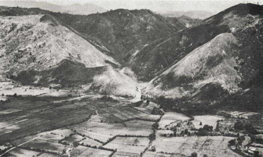
Facing the 6th Division between Montalban and San Mateo were the grassy, open, and steep slopes of Mt. Pacawagan, around 1,500 feet high, and Mt. Mataba, some 1,300 feet high. The barrier formed by these two heights, split by the deep, steep-sided gorge of the tiny Mango River, was oriented north to south and stretched for a distance of almost seven miles from the northern
Mts. Pacawagan and Mataba
slopes of Mt. Pacawagan to a shallow indentation made by the Nanca River. The barrier formed the northwestern and western extensions of a generally open and bare-sloped ridge and hill complex dominated by Mt. Baytangan, rising to a height of over 1,500 feet on the west bank of the Bosoboso River six miles southeast of Montalban. The Kobayashi Force had strong defenses on both Mt. Pacawagan and Mt. Mataba, and its positions extended south to an east-west line across Mt. Baytangan. Caves were not as numerous here as in the Noguchi Force’s zone, but the Kobayashi Force was prepared to employ skillfully the many defensive advantages afforded by the open, rough, and sharply rising terrain it held.
The 6th Division directed its initial attacks against both Mt. Pacawagan and Mt. Mataba, the 20th Infantry making the main effort. On 23 and 24 February the regiment gained little ground, and when the 1st Infantry arrived from Bataan on the 25th General Patrick, the division commander, decided to redeploy his forces. He ordered the new arrivals to clear the northern two-thirds of Mt. Mataba and the southern third of Mt. Pacawagan and then strike toward Wawa Dam in concert with the 63rd Infantry, which was to seize the northern two-thirds of Mt. Pacawagan. The 20th Infantry, on the right, would secure the southern third of Mt. Mataba; extend its right to an indentation made by the upper reaches of the little Ampid River, some two miles south of Mt. Mataba’s crest; and then strike east toward Mt. Baytangan and the corps objective line. Patrick hoped his three-regiment attack would achieve a decisive penetration of the Shimbu Group’s center –
the Kobayashi Force’s zone. If the center collapsed, Patrick reasoned, XIV Corps could probably roll up the flanks – the Kawashima and Noguchi Forces – rapidly.
Hopes were one thing, realization another. By 4 March right flank elements of the 63rd Infantry had gained a precarious foothold on the northern crest of Mt. Pacawagan, but the 1st Infantry, on the right, had not been able to clear its portion of that mountain and had also been unsuccessful in its attacks against Mt. Mataba. Right flank elements of the 20th Infantry made the only significant gains across the 6th Division’s front to 4 March. Unable to overrun Japanese defenses on its third of Mt. Mataba, the 20th concentrated its efforts along the Ampid River and broke almost two miles into Japanese positions on the southwestern and southern approaches to the mountain. At dusk on 4 March the regiment was ready to send troops northward along the crest of a 1,000-foot-high ridge leading to Mt. Mataba, or to strike eastward along another bare-crested, 1,000-foot-high ridge rising toward Mt. Baytangan. As in the 2nd Cavalry Brigade’s sector, the 6th Division’s gains had been disappointing. Moreover, since 22 February the division had lost approximately 85 men killed and 255 wounded in the equivalent of the two infantry regiments it had committed.13 The division and its supporting air and artillery had killed perhaps 1,100 Japanese.14
New Plans and Objectives
By 4 March General Griswold had decided that his corps was going to have more trouble cracking the Shimbu Group defenses than he had originally anticipated, and he had also determined that the success of his attack demanded concentration of forces across a narrower front.15 So far, employing two cavalry regiments (each less than two-thirds the strength of an infantry regiment) and the equivalent of two regiments of infantry, XIV Corps had been attacking across a front almost fifteen miles wide, north to south. Lacking the mass to succeed, the attack was doomed from the beginning in the face of the concentrated defenses of the Noguchi and Kobayashi Forces. Griswold had to commit additional strength on a narrower front, and he had to commit decisive strength in the area that in his opinion would provide the key to a breakthrough.
Griswold decided to concentrate against the Noguchi Force and the left of the Kobayashi Force. He thought his troops might be able to outflank the Noguchi Force on the south, an area now known to be weakly held, and to debouch into the Bosoboso Valley in order to surround and destroy the main body of the Noguchi Force. Meanwhile, if the attacks against the Kobayashi left succeeded, Griswold could subject the remainder of the Kobayashi Force to flanking attack from the south or strike it from the rear – from the Bosoboso Valley.
Griswold selected a limited area as the objective of the new XIV Corps effort, an oval-shaped piece of terrain lying about a mile and a quarter on each side of a line drawn due north for six and a half miles from Antipolo. The objective area had no particular terrain pattern. On the extreme north of the oval was the upper (eastern) end of the shallow Ampid River valley, just to the south of which lay the 1,000-foot-high, mile-wide, ridge leading east to Mt. Baytangan. The southern slopes of this ridge fell steeply off to the Nanca River valley, now to mark the boundary between the 1st Cavalry Division and the 6th Infantry Division. South of the Nanca River the terrain, quite open and extremely broken, was lower than that to the north, at only one or two places reaching a height of 1,000 feet. In general, the objective region contained the Noguchi Force’s strongest defenses as well as the positions of the Left Sector Unit, one of the Kobayashi Force’s three provisional infantry regiments. The Noguchi-Kobayashi Force boundary followed the ridge line rising east toward Mt. Baytangan.
In planning his new attack, Griswold entertained two misconceptions about the situation on the Shimbu Group’s western front. First, XIV Corps believed that the group’s tactical supply trails west of the Bosoboso River constituted the Japanese main north-south supply route. As yet having no information on the Antipolo–New Bosoboso–Wawa Dam road, XIV Corps believed that if it seized the new objective area it would sever the Shimbu Group’s main supply route. Second, the XIV Corps G-2 Section erroneously estimated that General Yokoyama had no reserves with which he could either reinforce his western front or stage a counterattack.
With this information at hand, Griswold planned to attack with virtually his entire force, hoping for quick success. He kept out only one battalion as an infantry reserve and directed the rest of his available forces, each component of which was understrength, to strike eastward.16 The 6th Division, for example, now had 2,630 fewer men than it had brought to Luzon. The entire 1st Cavalry Division was available, but its four regiments totaled only 5,100 effectives as against an authorized strength of over 7,625. The 112th Cavalry RCT, still attached to the 6th Division, had an authorized strength of roughly 2,625, but could muster less than 2,000 effectives as of the first week in March. None of the units had received any replacements, other than returned casualties, since arriving on Luzon.17 The only reserve for the 6th Division was the infantry battalion that also served as XIV Corps Reserve. Initially, the 1st Cavalry Division had only one cavalry squadron as a reserve, but the 103rd Infantry, 43rd Division, reached Taytay on 7 March to become 1st Cavalry Division Reserve.
The arrival of the 103rd Infantry presaged the imminent relief of the 1st Cavalry Division in preparation for redeployment to southern Luzon, a process that again required considerable reshuffling of Sixth Army units. In deciding
to employ the 43rd Division to relieve the 1st Cavalry Division, General Krueger selected a unit that, having been in action ten days against the Kembu Group after replacing the 40th Division west of Clark Field, would have virtually no rest before moving to the attack against the Shimbu Group. Krueger chose to use the 43rd Division instead of the relatively fresh 38th Division, which had seen little action since reducing Bataan’s ZigZag Pass on 15 February, because he had greater confidence in the 43rd, a more experienced division.18
The arrival of the 43rd Division’s 103rd Infantry on the Shimbu front, together with the fact that the rest of the division was on its way from the Kembu area, may well have influenced Griswold to launch his attack with virtually his entire force. Whatever the reasons for the decision, XIV Corps was to undertake a new drive on a bit of a shoestring, even though it had now concentrated its forces on a narrower front. If the Shimbu Group proved stronger than anticipated, or if that Japanese force could mount an effective counterattack, XIV Corps might be in for trouble.
Attack and Counterattack,
8-15 March
General Griswold directed the 1st Cavalry Division and the 6th Infantry Division to strike on 8 March. By evening on the 7th the 1st Cavalry Brigade, coming in from Manila, had moved up to a line of departure a mile and a half into the Sierra Madre foothills to the north and west of the 2nd Cavalry Brigade.19 The 2nd Brigade attacked from positions astride Route 60-A, its lines extending from the highway a mile and a half west of Antipolo southeast to Benchmark 11 Hill, a mile south of the town. As operations developed, the 1st Cavalry Division found that Noguchi Force defenses took the form of an elongated Z. The Japanese lines slanted northwest from Benchmark 11, crossing Route 60-A a mile west of Antipolo; switched back northeast to Benchmark 9 Hill, a mile north of Antipolo; then led northwest again to the Nanca River at Hill 740. The Noguchi Force also had a strong outpost on Hill 520, three-quarters of a mile west of Hill 740.
For the 2nd Cavalry Brigade, operations after 8 March continued in the same style to which the unit had become all too thoroughly accustomed. By 11 March, when elements of the 43rd Division came into the line, the 2nd Brigade’s left was across Route 60-A a quarter of a mile short of Antipolo; right flank units had overrun cave defenses on Benchmark 11. Patrols had entered Antipolo, finding the town shattered and empty, but still covered by Japanese artillery and mortars emplaced in the hills to the north and northeast. Generally, the 2nd Brigade held positions just into the southwestern edge of XIV Corps’ oval-shaped objective area.
The 1st Brigade’s attack had been somewhat more successful. By 11 March its right flank, having fought every inch of the way, had cleared the bus road to within a quarter of a mile of Antipolo. The brigade had also secured Benchmark 9 and had pushed a mile northeast of Benchmark 9 and seized an unnamed hill, 800 feet high, lying at the very center of that portion of the XIV Corps’ objective area within the 1st Cavalry Division’s zone. In addition, the brigade had cleared Hills 520 and 740, but the units on its left had barely reached the line marking the western limits of the corps’ objective oval.
Results of the 6th Division’s offensive were more promising. Deciding that he needed two regiments on his right to assure success, General Patrick had pulled the 1st Infantry from the approaches to Mt. Mataba and sent it south to the 20th Infantry’s right. Directed to drive east across a two-mile-wide front with its right on the Nanca River, the 1st Infantry was to secure almost all of that portion of the XIV Corps’ objective area lying within the 6th Division’s zone, simultaneously clearing much of the mile-wide ridge rising to Mt. Baytangan. The 20th Infantry, in support, would be ready either to reinforce the 1st Infantry or, assuming the success of the 1st Infantry’s attack, drive north toward Wawa Dam along the trails believed to constitute the Shimbu Group’s main north-south supply route.
The redeployment of the 1st Infantry left a gap in the 6th Division lines that the 63rd Infantry might have filled, but Patrick did not feel that that regiment was strong enough to maintain all the tenuous holds the division had secured on the rising ground east of the Marikina River from San Mateo north to Montalban. He therefore gave up that area, including the toe hold on Mt. Pacawagan, and directed the 63rd Infantry to establish a defensive line west of the Marikina from San Mateo north to hills about two miles northwest of Montalban. The 20th Infantry withdrew from some of the ground it had secured further south to concentrate its forces, abandoning positions on the southern and southwestern slopes of Mt. Mataba. Patrick directed the 112th Cavalry RCT to continue to protect the 6th Division’s flank north and northwest of the 63rd Infantry.20
During the first two days of the attack the 1st Infantry, encountering unexpectedly light opposition, secured positions along the western end of the 1,000-foot ridge leading east to Mt. Baytangan. On the 10th the regiment committed more strength to keep pace with the 1st Cavalry Brigade, to the south, and to take Benchmark 8 Hill. Lying two and a half miles north of Benchmark 9 in the 1st Brigade’s zone, Benchmark 8 dominated the terrain between Benchmark 9 and the ridge line approach to Mt. Baytangan. The seizure of Benchmark 8 would secure for the 6th Division some of the advantages of observation so far reserved to the Japanese.
The 1st Infantry drove a mile and a half into the northern section of the XIV Corps’ objective area by evening on 11 March, penetrating deeply between the Kobayashi left and the Noguchi right. The regiment seized Benchmark 8 against stubborn resistance and cleared
a third of the northern half of the corps objective. The 1st Infantry also cut two north-south trails of the presumed Shimbu main supply route.21 Feeling that the 1st Infantry’s success demanded exploitation, General Patrick directed the 20th Infantry to institute an immediate drive northward toward Wawa Dam along the trails the 1st Infantry had cut. The latter regiment would continue its attack eastward.22
There were additional changes in plans for operations farther south. The 103rd Infantry relieved the 2nd Cavalry Brigade on 11 March and began preparations to outflank Noguchi Force defenses southeast of Antipolo beginning on 12 March. The 172nd Infantry of the 43rd Division was on its way forward to take over from the 1st Cavalry Brigade, and General Wing, the 43d’s commander, had plans to undertake a concerted attack of his own on 14 March, when he was to assume responsibility for the further conduct of operations on the XIV Corps right.23
At this juncture General Yokoyama, the Shimbu Group commander, decided to take a more decisive hand in the proceedings.24 Greatly concerned over the 6th Division’s penetration along the Kobayashi-Noguchi boundary, Yokoyama recognized all the threats contained in or implied by the division’s advance. He was also perturbed by the 1st Cavalry Division’s progress on the Noguchi Force left and about 10 March decided that the Noguchi Force’s forward positions were no longer tenable. Accordingly, Yokoyama directed the Noguchi Force to pull back to second-line defenses, which had been under construction for over a month. The new line was anchored on the north about a mile and a half west-southwest of Mt. Baytangan on the ridge line along which the 1st Infantry, 6th Division, was advancing. The line then ran south nearly three miles from the ridge to Sugarloaf Hill and swung thence southeast across the Morong River valley for some five miles to Benchmark 23 Hill, which, lying six miles east of Antipolo, controlled the open, rocky, southern approaches to the Bosoboso Valley.
Yokoyama might also have pulled back the Kobayashi Force – its left having already been pushed eastward – but for a variety of reasons decided not to do so. For one thing, the Kobayashi left was now almost as far east as the right of the new Noguchi Force line. Moreover, on the Kobayashi center and right there was neither the good defensive terrain nor the necessary maneuver room between the existing front and the Bosoboso Valley requisite to the establishment of a new line. Therefore, any withdrawal of the Kobayashi center and right might have to be carried all the way across the Bosoboso River. Such a course of action would mean abandoning the excellent defensive positions on Mts. Pacawagan and Mataba and giving up Wawa Dam without a fight. Yokoyama
was by no means ready to take such steps, and it appeared to him, accordingly, that if the Kobayashi Force could not withdraw, and if it could not hold on its left, he would have to counterattack to eliminate the 6th Division’s salient.
The Shimbu Group commander settled upon a counterattack plan typifying a major weakness of Japanese tactical operations throughout World War II. He scheduled a series of complicated maneuvers that required meticulous coordination in terrain where such coordination was virtually unattainable and that demanded a control of communications that the Shimbu Group did not possess. His artillery was neither strong enough nor suitably deployed to provide proper support for the counterattack; he had to employ a large proportion of provisional units and second-class troops who had little or no unit training. Under the circumstances, even the best-trained units would have found execution of Yokoyama’s plan a most challenging task.
The Shimbu Group counterattack was to begin on 12 March with a three-pronged assault by seven infantry battalions. The main effort would be launched by three battalions of the Shimbu Group Reserve – two of the 31st Infantry and a provisional battalion – plus an independent infantry battalion of the 105th Division that Yokoyama detached from the Noguchi Force. These four, assembling near Wawa Dam, would march west past the dam and then south to a line of departure at Mt. Mataba, whence they would strike south and southeast against the 6th Division salient. Another Noguchi Force independent infantry battalion, turned over to Kobayashi Force control, was to attack from the east to recapture Benchmark 8 Hill and hit the right flank of the 6th Division salient. Finally, the Kawashima Force was to send its lone independent infantry battalion, together with a provisional battalion, south from the Ipo Dam area to attack 6th Division rear installations west of the Marikina River.
Just how Yokoyama expected his counterattack to succeed is not clear. In mid-February he had launched an unsuccessful attack with a stronger force against a much weaker concentration of XIV Corps troops.25 It might therefore be presumed that Yokoyama now had his tongue in his cheek – that he really did not hope for success and that he was actually staging a delaying action. In any event, he did not know that his counterattack was to start on the very day that the 6th Division was to launch a new offensive. Even if all went well, the four Japanese battalions attacking south from Mt. Mataba would, on 12 March, come face to face with the 20th Infantry instituting its drive north toward Wawa Dam. The Japanese battalion striking toward Benchmark 8 would, by the same token, clash with right flank elements of the 1st Infantry as that regiment renewed its thrust toward Mt. Baytangan.
Operations did not go at all well for the Shimbu Group.26 First, air and
artillery strikes paving the way for the 6th Division attack of 12 March knocked out or forced into cave hideaways many of the artillery pieces upon which the Japanese had depended for support of their counteroffensive. Then, the American artillery interdicted or rendered temporarily impassable many trails that the five southernmost Shimbu Group battalions were to employ as routes of approach, disrupted the group’s already inadequate communications, struck and put out of action many command posts, and made untenable the four-battalion assembly area at Mt. Mataba. American air and artillery bombardments also inhibited movement of the Kawashima Force’s counterattack units. As a result, the Shimbu Group counterattack was broken up virtually before it got under way. Demoralized units dispersed all through the hills, commanders lost control of their men, contact between units ceased. What followed bore no resemblance to Yokoyama’s plans, and the counterattack turned into an abysmal failure. To illustrate how striking that failure was, it is only necessary to record that the 6th Division had no idea it was being attacked. Instead, the division merely reported particularly persistent but otherwise not unusual night infiltration operations by small groups of Japanese during the period 11 through 15 March.
Disgusted, Yokoyama called off the effort on 15 March. The failure vividly demonstrated to him that the Shimbu Group was incapable of effective offensive action, and the counterattack had resulted in losses Yokoyama knew he could ill afford. The Noguchi Force had been irretrievably weakened by the near annihilation of the two battalions Yokoyama had taken from it for the counterattack; participating units of the Shimbu Group Reserve had also suffered heavily. To Yokoyama, the ultimate fate of the Shimbu Group was even more obviously a foregone conclusion than it had been when XIV Corps began its attack on 20 February. All he could do now was to trade lives for terrain and time.
Final XIV Corps Operations, 12-14 March
While the so-called counterattack was under way, the Noguchi Force had been executing its withdrawal, hurried along by pressure from elements of the 43rd Division.27 On 12 March the 103rd Infantry (under 1st Cavalry Division control) occupied Antipolo and on the next day sent troops cross-country toward Benchmark 7 Hill, two and a half miles to the southeast. Controlling the Morong Valley for two miles north and south of Route 60-A, Benchmark 7, the 103rd Infantry believed, was the southern anchor of Noguchi Force defenses. The regiment was not surprised, therefore, to find considerable Japanese strength on the hill, but it was astonished when reconnaissance elements found undefended the junction of Routes 60-A and 21, four miles southeast of Benchmark 7. It appeared that except for the isolated groupment at Benchmark 7 the Noguchi Force left flank was wide open.
The 43rd Division planned to exploit this weakness with an attack beginning on 14 March, when it had completed relief of the 1st Cavalry Division. First clearing the remainder of XIV Corps’ oval-shaped objective area within its zone, the 43rd Division intended to drive on east and northeast to rough, open, high ground along the west side of the Bosoboso Valley. General Wing hoped his troops could gain the top of a bare-crested, north-south ridge line dominated by Mt. Yabang, a mile and a half southeast of Mt. Baytangan in the 6th Division’s zone. Steep-sloped Mt. Caymayuman, three-quarters of a mile south of Mt. Yabang and on the same ridge line, was another 43rd Division objective. The 172nd Infantry, striking north up the Morong Valley, was to seize Mts. Yabang and Caymayuman. The 103rd Infantry would first clear Benchmark 7 and secure Route 60-A from Antipolo to the junction with Route 21, and would then strike north along the east side of the Morong Valley to Mt. Tanauan, a bare-sloped, rough height two miles south-southeast of Mt. Caymayuman. Forming part of the ridge complex that included Mts. Yabang and Caymayuman, Mt. Tanauan controlled the northern end of the Morong Valley as well as the extreme southeastern reaches of the Bosoboso Valley. If the 43rd Division’s attack against Mts. Yabang, Caymayuman, and Tanauan proved successful, the division would have overrun the Noguchi Force’s principal second-line defenses, would have turned the Shimbu Group’s left, and would have opened a route into the Bosoboso Valley.
On 14 March, against scattered, light resistance, the 172nd Infantry cleared the southern third of the XIV Corps’ oval objective area, while the 103rd Infantry secured most of Route 60-A. Noguchi Force units at Benchmark 7 conducted a stubborn defense, but elements of the 103rd Infantry probing north along the eastern side of the Morong Valley encountered only a few stragglers. Not knowing that the Noguchi Force was withdrawing to new defenses, the 43rd Division faced the prospect of continuing the attack on 15 March with considerable enthusiasm. And why not? Having gained up to a mile and a half on its center and left, the division had made as much progress in one day as had the 1st Cavalry Division during the previous ten.
Meanwhile, the attack the 6th Division had launched on 12 March had also gained some measure of success.28 From 12 through 14 March the 20th Infantry drove over a mile northward on the 1st Infantry’s left, cleaned out the extreme northern portion of the XIV Corps’ objective area, and secured a foothold on a grassy, open ridge less than a mile southeast of Mt. Mataba’s peak, opening a new axis of advance toward the mountain. The 1st Infantry did not begin its part of the attack until the 14th, finding it necessary to spend the 12th and 13th mopping up and waiting for the improvement and extension of regimental supply roads. Once under way, the regiment encountered steadily increasing resistance. About midmorning on the 14th, a burst of Japanese machine gun fire from a hidden position caught a group of officers who

Benchmark 7
were incautiously bunched in the open at the regiment’s forward command post. General Patrick was mortally wounded and Col. James E. Rees, the 1st Infantry’s commander, was killed outright. Brig. Gen. Charles E. Hurdis. division artillery commander, replaced General Patrick; Lt. Col. Francis J. Corbin, previously commander of the 1st Battalion, 1st Infantry, took over the regimental reins.
By midafternoon on the 14th strong Japanese opposition had brought the 1st Infantry to a halt, yet the regiment’s left had driven all the way across XIV Corps’ oval objective area and was on a bare peak some 1,250 feet high only a mile and a quarter southwest of Mt. Baytangan. The right flank had pushed about halfway across the corps’ objective oval and had kept pace with the 43rd Division’s left along the Nanca River.
By evening on 14 March XIV Corps had made substantial contributions toward the destruction of Shimbu Group. Progress had often been painfully slow and costly, but it had been steady. The corps had driven a wedge deep between the Noguchi and Kobayashi Forces, it had compelled General Yokoyama to pull the Noguchi Force back to second-line defenses, it had prompted Yokoyama to launch a costly and unsuccessful counterattack, and it had gone far toward
turning the Shimbu Group left. These achievements XIV Corps had made against a well-armed Japanese force that had held strong positions in excellent defensive terrain and that had – for the Japanese Army – made uncommonly fine use of its artillery. Finally, XIV Corps estimated (conservatively) that it had killed some 3,350 troops of the Shimbu Group from 20 February through 14 March.
On the debit side of the ledger were XIV Corps’ own battle casualties:–29
| Unit | Killed | Wounded | Total |
| 1st Cavalry Division | 130 | 585 | 715 |
| 6th Infantry Division | 150 | 420 | 570 |
| 43rd Infantry Division | 10 | 25 | 35 |
| 112th Cavalry RCT | 5 | 10 | 15 |
| Total | 295 | 1,040 | 1,335 |
Non-battle casualties also took a heavy toll of effective front-line strength. For example, over 1,600 troops of the 6th Division had to leave the front because of sickness or combat fatigue.30
The second debit factor was that XIV Corps had launched no offensive toward Ipo Dam. On the other hand, the 6th Division was farther from Wawa Dam than it had been ten days earlier, when the 63rd Infantry had given up its hold on Mt. Pacawagan. Moreover, XIV Corps had launched no offensive toward Ipo Dam. On the other hand, the 6th and 43rd Divisions had an uncontestable hold on the ground gained through 14 March, and they had secured good positions from which to continue their drives east and north.
The Collapse of the Shimbu Left
Late on 14 March General Hall, commanding XI Corps, took over responsibility for the conduct of operations against the Shimbu Group. It was up to him to determine how best to employ the 6th and 43rd Divisions so as to exploit the gains made by XIV Corps and to speed the capture of Wawa and Ipo Dams.
XI Corps and Shimbu Group Plans
General Hall decided to continue the drive against the Shimbu Group’s left, the only real difference between his plan and that followed by General Griswold being that Hall intended to concentrate initially against the Noguchi Force instead of operating against both that unit and the left of the Kobayashi Force as had XIV Corps.31 XI Corps based its plan on an overoptimistic intelligence estimate that the Kobayashi and Noguchi Forces were no longer in contact and that the Kobayashi Force had few if any troops south of the Mango River, which separates Mts. Pacawagan and Mataba. Once the Noguchi Force was destroyed, Hall reasoned, he would swing XI Corps north against the Kobayashi Force and, finally, concentrate all his units to destroy the Kawashima Force.
Whatever Hall’s intentions, he actually continued the attack against the Kobayashi Force left, for he ordered the 6th Division to resume the drive eastward it had initiated under XIV Corps control. Hall left unchanged the existing
boundary between the 6th and 43rd Divisions; at first set up no specific objectives for either unit; drew no definite objective lines. For the 43rd Division, the XI Corps orders required no change in plans. The 6th Division, on the other hand, had to forego its plan to swing the 20th Infantry northward, and had to concentrate for a drive eastward abreast of the 43rd Division. Directed to secure the ridge line overlooking the Bosoboso Valley from the northern slopes of Mt. Yabang north as far as Mt. Baytangan, the 6th Division instructed the 20th Infantry to strike eastward in concert with the 1st Infantry. The new boundary between the two regiments, drawn along the 1,000-foot-high ridge line rising eastward to Mt. Baytangan, coincided closely to that between the Noguchi and Kobayashi Forces.
The Noguchi Force had completed its withdrawal on 15 March, as scheduled, but had not taken up the exact lines General Yokoyama had expected.32 The force’s center and right had occupied good defenses extending from Sugarloaf Hill north almost two miles across the Nanca River, holding Sugarloaf Hill with about a battalion of infantry and the area to the north with another infantry battalion. But the Noguchi Force had been unable to assemble sufficient strength to hold the Sugarloaf-Benchmark 23 section of its intended second defensive line and had therefore concentrated its left flank strength, a reinforced independent infantry battalion of the 105th Division, at Mt. Tanauan in partially completed defenses originally intended as part of a third defensive line. A provisional infantry battalion held Mts. Yabang and Caymayuman to back up the Sugarloaf-Mt. Tanauan line. Elements of the Kogure Detachment, which had just sent about half its effectives north to reinforce the Noguchi Force, were also in the Mts. Yabang-Caymayuman-Tanauan area.
As of 15 March the Kobayashi Force’s Left Sector Unit was desperately trying to stabilize its lines. On or about the same day at least one battalion of the Shimbu Group Reserve moved up to reinforce the Left Sector Unit, which also absorbed remnants of some organizations chopped up during the Shimbu Group counterattack. The unit’s front lay a mile to a mile and a half west of Mt. Baytangan and extended north to south from some two and a half miles across the ridge leading to the mountain.
General Yokoyama still viewed the Kobayashi Force left as the critical area along the Shimbu front, for he knew that his entire left flank would collapse if the 6th Division penetrated any further toward Mt. Baytangan. Having failed to eliminate the 6th Division’s salient, he now intended to contain it, and he accordingly directed the Kobayashi Force to maintain its left at all costs.
XI Corps’ First Week
On the morning of 15 March the 103rd Infantry, 43rd Division, set grimly about the task of reducing the Japanese defenses on Benchmark 7 Hill and clearing a two-mile stretch of Route 60-A
that the Japanese still controlled.33 Both tasks had to be completed in order to secure Route 60-A as a line of communication for the support of the planned regimental attack north up the Morong Valley. The 103rd Infantry finally overran the defenses on Benchmark 7 on 18 March, killing about 250 Japanese in the process.34 The Japanese battalion there had delayed the 103rd’s attack toward Mt. Tanauan until the morning of 18 March, but by evening of that day the regiment’s troops had begun swarming up the bare, rocky, southern and southwestern slopes of the mountain. For the next three days the 103rd Infantry literally inched its way upward through a maze of cave and bunker defenses, spending much of its time pinned down by Japanese machine gun and artillery fire. Fighting on behind the close support of air, artillery, and mortar fire, the 103rd reached the crest of Mt. Tanauan late on 21 March as the remnants of the Noguchi Force’s defending battalion, leaving some 300 dead behind, fled northeast across the Bosoboso River.
Meanwhile, other troops of the 103rd Infantry had taken Benchmark 23 Hill, three miles southeast of Mt. Tanauan, and had patrolled northward into the southeastern reaches of the Bosoboso Valley. On 22 March a combat patrol reached Mt. Balidbiran, on the east bank of the Bosoboso a mile and a half east of Mt. Tanauan. The 103rd Infantry had outflanked the Noguchi Force left and had driven that unit’s leftmost elements across the Bosoboso.
To the north, the 172nd Infantry had at first struck to seize grassy-sloped Sugarloaf Hill, two and a quarter miles west of Mt. Tanauan. The Japanese fanatically defended all the rough approaches to the hill and by evening on the 19th had stopped the 172nd Infantry in its tracks. Accordingly, the regiment contained Sugarloaf on the west and, bypassing it to the north and east, began new attacks toward Mts. Yabang and Caymayuman. The 1st Battalion, moving across the northern end of the Morong Valley along the Shimbu Group’s real main north-south supply route, encountered only a few delaying positions and by evening on 22 March had reached a point about three-quarters of a mile southeast of Mt. Caymayuman’s crest. The 2nd Battalion, bypassing Sugarloaf Hill on the north, had not done as well, and at the end of XI Corps’ first week of attack was still a mile and a half west of Mt. Yabang.
The 6th Division’s initial attack under XI Corps control did not begin until 17 March.35 That day the 1st Infantry jumped off with its 1st Battalion along the ridge rising toward Mt. Baytangan
and the 3rd Battalion striking east from the vicinity of Benchmark 8 Hill. Until late afternoon the attack went well, and at 1700 the 1st Battalion began digging in along the ridge a little over a mile west-southwest of Baytangan’s crest while the 3rd Battalion dug in about three-quarters of a mile southwest of the 1st.
An hour later the roof fell in on the 1st Battalion. First, at least sixty rounds of 150-mm. mortar fire struck the two forward companies. Then, lighter mortars began bombarding the battalion’s lines as Japanese infantry started maneuvering against the unit’s exposed northern and southern flanks. Its positions rapidly becoming untenable, the battalion withdrew over a mile westward, back beyond its morning line of departure, with losses numbering 12 men killed and 35 wounded. The unit left behind an artillery liaison radio, a jeep, two 37-mm. antitank guns, two 60-mm. mortars with ammunition, and some .30-caliber rifle ammunition.
After this reverse, the 1st Infantry adopted new tactics. Spending one day advancing generally eastward, mainly in a series of patrol actions, the regiment would spend the next day consolidating its gains and mopping up. The Japanese continued to put up determined but somewhat disorganized resistance and nightly launched infiltration attacks all across the 1st Infantry’s front. Japanese artillery and mortar fire also harassed the regiment continuously and delayed the construction of supply roads, already a difficult enough task in the very rough and broken ground through which the 1st Infantry was fighting. By dusk on 22 March the regiment was little closer to Mt. Baytangan’s crest than it had been on the 17th.
The 20th Infantry had also met stubborn resistance in its sector on the 1st Infantry’s left. Although the opposition to the 20th Infantry was not well organized, it was so widespread that the regiment found it difficult to concentrate forces at any one point to achieve decisive penetrations and, like the 1st Infantry, had to advance in a series of patrol actions. By evening on 22 March the 20th was generally a mile and a half west of Mt. Baytangan, but one company, working around to the north, had gained a foothold on a wooded ridge overlooking the Bosoboso Valley less than a mile west-northwest of Baytangan’s crest.
By this time General Hall, the XI Corps commander, had begun to feel that the 6th Division was bogged down in interminable small unit actions. In the 43rd Division’s area the 172nd Infantry’s gains were scarcely more satisfying. Only in the 103rd Infantry’s sector had progress been such that Hall could still feel that his plans were basically sound. Meanwhile, steady attrition from both battle and nonbattle casualties had reduced the effective strength of the four regiments committed. Together, they had lost approximately 120 men killed and 325 wounded during the period from 15 through 22 March. The rifle companies of the 172nd Infantry had few more than 50 effectives apiece; the 1st and 20th Infantry Regiments were 900 and 850 effectives, respectively, under authorized strength. Each of the four regiments in the line was losing 55-60 men a day killed, wounded, injured, or evacuated for sickness or combat fatigue. Such attrition would soon destroy the regiments as effective combat units, and it began to appear that XI Corps would
have to halt until the regiments could either be replaced or brought back up to strength. Certainly, a stalemate, jeopardizing the success of the corps’ plans, threatened.
The Shimbu Group Withdraws Its Left
Shimbu Group solved XI Corps’ immediate problems in a most unexpected fashion. By 20 March, since the Kobayashi Force had slowed but not halted the 6th Division, General Yokoyama had decided that the situation of his left was hopeless. Accordingly, he directed the Kobayashi Force Left Sector Unit and the entire Noguchi Force to fall back to new positions east of the Bosoboso River. He issued these orders on 20 March, but such was the state of the Shimbu Group’s communications that most of the forward units did not get the word until late on the 22nd. The Japanese units concerned began retreating eastward during the night of 22-23 March, and when the 6th and 43rd Divisions resumed their attacks on the morning of the 23rd the withdrawal was in full swing.36
The 6th and 43rd Divisions encountered only scattered, disorganized opposition from 23 through 26 March.37 On the far left, or north, the 20th Infantry met little resistance as it cleared more ground along the western and northern slopes of Mt. Baytangan and sent patrols across the mountain’s northern shoulder as far as the Bosoboso River. By evening on the 26th that regiment and the 1st Infantry had secured positions for over a mile north and south of Mt. Baytangan along the ridge line overlooking the Bosoboso Valley; the 1st Infantry took the crest of the mountain the next day against no opposition. On 26 March the 1st Infantry made contact with the 172nd Infantry, 43rd Division, at a point about a mile northwest of Mt. Yabang.
The 172nd had seized Mt. Yabang against scattered resistance on the morning of 24 March and had also cleared most of Mt. Caymayuman the same day. The regiment overran the last organized opposition in its sector, that at Sugarloaf Hill, on the morning of the 27th.
In the meantime, the 103rd Infantry had been making easy gains along both sides of the Bosoboso River. The regiment occupied barrio New Bosoboso on the 24th, capturing great quantities of supplies of all types in the area. Mt. Balidbiran, on the east bank, fell the same day, as did Benchmark 21 Hill, a mile and a half further east. Signs of recent and hurried Japanese withdrawal abounded throughout the regiment’s sector, and the only indications of organized Japanese activity were foot and motor movements along a rough road leading northeast from New Bosoboso into the fastnesses of the Sierra Madre. The Shimbu Group’s left had disappeared.
Conclusions
With the collapse of the Shimbu Group left, XI Corps could turn its attention
to the capture of Wawa Dam and the destruction of the Kobayashi Force elements remaining west of the Bosoboso River. The gains of 15 through 26 March that put XI Corps in position to make plans for an attack toward Wawa Dam had been achieved at some cost:–38
| U.S. Casualties | Japanese | |||
| Unit | Killed | Wounded | Total | Killed |
| 1st Infantry | 35 | 105 | 140 | 635 |
| 20th Infantry | 35 | 90 | 125 | 1,515 |
| 103rd Infantry | 40 | 90 | 130 | 625 |
| 172nd Infantry | 30 | 110 | 140 | 450 |
| Total | 140 | 395 | 535 | 3,225 |
The total cost of XI and XIV Corps operations against the Shimbu Group from 20 February through 26 March was approximately 435 men killed and 1,425 wounded; the Japanese had lost nearly 7,000 killed during the same period.39
As far as General Yokoyama was concerned, the decisive operation since the beginning of XIV Corps’ attack on 20 February had been the 6th Division’s penetration between the Kobayashi and Noguchi Forces. This penetration had rendered the Shimbu Group’s left flank defenses untenable and, threatening encirclement of the Noguchi Force, had prompted Yokoyama to withdraw his left well before he had anticipated doing so. Of only slightly lesser importance had been the 43rd Division’s penetration into the Bosoboso River valley from the south, a penetration that would ultimately have forced Yokoyama to withdraw his left even if the 6th Division had not driven its wedge deep between the Kobayashi and Noguchi Forces. From the XI and XIV Corps points of view, the two American drives – the one conducted by the 6th Division and the other executed first by the 1st Cavalry Division and then taken up by the 43rd Division – must be considered as complementary. Manifestly, the simultaneous drives had hastened the collapse of the Shimbu left.
Had the two corps had more strength, they could have achieved the same results more quickly. The 6th Division had been able to commit only two regiments to the attack, finding it necessary to hold the 63rd Infantry out to safeguard its left rear. Only two regiments of the 43rd Infantry had been available, and neither brigade of the 1st Cavalry Division had been much stronger than an infantry regiment. Throughout the attack XIV and XI Corps had been operating on shoestrings holding out scant reserves and expecting normal results from generally understrength units.
The Shimbu Group’s operations to 26 March reflected many of the group’s weaknesses, such as the heterogeneous nature of its forces, the preponderance of second-class, ill-trained troops, the inadequate strength of the Noguchi Force for the mission assigned it, poor communications, and the gradual deterioration of control all across the group’s southern front. On the other hand, that the Shimbu Group was able to maintain its left for over a month indicates that Yokoyama’s defenses were generally well conceived and long in preparation.
Throughout the period, moreover, the Japanese had all the advantages of terrain and observation. General Yokoyama had another important, if immeasurable, factor working for him – the willingness of the Japanese soldier to fight and die in place no matter how hopeless his situation.