Chapter 23: Securing the Visayan Passages
Sixth Army had not waited for the destruction of the Shimbu Group, nor even for the capture of Wawa and Ipo Dams, to launch operations to clear southern Luzon, to secure the northern side of the Visayan Passages, and to gain control over the shores of Batangas and Balayan Bays in order to develop logistical bases there. General Krueger’s plans for Sixth Army’s share in the program to clear the Visayan Passages called for XIV Corps to strike into southern Luzon during the first week of March, by which time that corps’ attack against the main body of the Shimbu Group in the mountains east of Manila would be less than two weeks old. First, XIV Corps would secure those sections of the northern shores of the Visayan Passages lying west of the Bicol Peninsula of southeastern Luzon, simultaneously clearing the Batangas–Balayan Bays area. Once XIV Corps operations in southern Luzon were well under way, Sixth Army would stage an amphibious attack against the southeastern section of the Bicol Peninsula to secure the northern side of the eastern entrance to the Visayan Passages. Forces undertaking the Bicol operation would ultimately drive northwestward up the peninsula to establish contact with XIV Corps units advancing eastward across southern Luzon, thereby completing the task of clearing the northern littoral of the passages. Meanwhile, Eighth Army would be chasing the Japanese from northern Samar, at the south side of the eastern entrance to the Visayan Passages, and then, in a series of minor amphibious operations, would seize the smaller islands lying athwart the shipping routes through the inner sections of the passages.1
Southern Luzon
Fitting the Plan to the Terrain
For descriptive purposes in this narrative, southern Luzon is considered to be that part of the island lying west of the Bicol Peninsula and south of Laguna de Bay. Two narrow corridors on either side of Laguna de Bay provide access to southern Luzon from Manila, while the nine-mile-wide Bondoc Isthmus, separating Lamon Bay on the north from Tayabas Bay on the south, connects southern Luzon to the Bicol Peninsula. Balayan, Batangas, and Tayabas Bays, reading west to east, scallop the south coast of southern Luzon. The region contains some rough, mountainous country, but much of it, immensely productive agriculturally, is flat or gently
rolling terrain well suited to the development of major air and logistical bases. (Map IX)
Three terrain complexes dominate southern Luzon: the Lake Taal Upland on the west, the Mt. Banahao District to the east, and the Batangas Mountains on the south-central coast. The great caldera, or volcanic depression of Lake Taal, centering forty miles south of Manila, is fourteen miles long north to south and about eight miles wide. Nearly surrounded by a steep rim, Lake Taal drains into the northeastern corner of Balayan Bay. Rocky, alternating ridges and gullies, radiating like the spokes of a wheel from the encircling escarpment, inhibit movement around the caldera.
Mt. Banahao, like the Lake Taal caldera, is another volcanic formation, but one that rises sharply from surrounding flat ground. Dominating the eastern section of southern Luzon, 7,150-foot-high Mt. Banahao drops off to Laguna de Bay on the north and to Tayabas Bay on the south. Its eastern slopes fall away to a saddle leading to the southern ridges of the Sierra Madre, in turn descending steeply to Lamon Bay or giving way to the rough hills of the Bondoc Isthmus. Banahao’s western slopes descend to flat ground off the eastern side of Mt. Malepunyo, which lies between Mt. Banahao and the eastern ridges of the Lake Taal caldera.
The Batangas Mountains, forming a 30-mile-wide peninsula between Batangas and Tayabas Bays, lie southwest of Mt. Banahao, south of Mt. Malepunyo, and southeast of Lake Taal. The mountains drop sharply away on the south to a steep, broken coast line overlooking the Verde Island Passage, the name given that section of the Visayan Passages lying between southern Luzon and northern Mindoro. The northern reaches of the Batangas Mountains slope more gently to a generally flat farming region.
Served by a good highway and railroad network (there are no navigable streams), southern Luzon is compartmentalized by corridors that, separating the principal terrain complexes, channel military traffic. The easiest axis of advance from Manila into southern Luzon is a narrow flat along the western and southwestern shores of Laguna de Bay. From the west side of the Hagonoy Isthmus, separating Laguna de Bay and Manila Bay, two good roads, Routes 25 and 17, follow rising ground from the vicinity of Cavite to the Lake Taal escarpment at Tagaytay Ridge, where the 511th Parachute Infantry had dropped during the 11th Airborne Division’s drive from Nasugbu to Manila in February. The ground west of Lake Taal largely confines military maneuver to Route 17 from Tagaytay Ridge to the Nasugbu area. Near Nasugbu the highway turns southeast across rough ground leading to the northwest corner of Balayan Bay. A narrow, flat corridor extends along the northern shore of Balayan Bay and, passing south of Lake Taal, provides access from the west to the northern shores of Batangas Bay. A five-mile-wide corridor separating the Batangas Mountains and the Mt. Malepunyo complex connects the flats at Batangas Bay to coastal plains at Tayabas Bay. Another narrow, east-west corridor, controlled by Mt. Maquiling and associated high ground, follows the southern shore of Laguna de Bay. A third east-west corridor is a mile-wide, sharp defile between the southern section of the Mt. Maquiling complex and the northern slopes of Mt. Malepunyo.
Centering about ten miles east of Lake Taal, Mt. Malepunyo gives way on the west to the most important north-south corridor of southern Luzon – the Lipa Corridor. Connecting the southwestern shores of Laguna de Bay to the Batangas Bay plains, the Lipa Corridor is bounded on the west by the Lake Taal caldera and on the east by Mts. Malepunyo and Maquiling. At the center of the Lipa Corridor (which provides access to all the east-west corridors) lies the commercial center of Lipa, near which the Japanese had partially completed an ambitious airfield complex.
Another north-south corridor, between Mts. Maquiling and Malepunyo, on the west, and Mt. Banahao, on the east, connects the southern shore of Laguna de Bay to the northwestern corner of the Tayabas Bay plains. A third north-south corridor, less well-defined than the other two, follows the saddle between Mt. Banahao and the Sierra Madre to join the southeastern corner of Laguna de Bay to the northeastern section of the Tayabas Bay flats.
American planners clearly understood that control of the Lipa Corridor was requisite to the successful prosecution of operations in southern Luzon.2 XIV Corps, accordingly, planned to drive rapidly south and east through the western and central portions of southern Luzon, securing all the ground east to include the Lipa Corridor. In the course of this drive the corps would clear the northern side of the Visayan Passages east as far as Batangas Bay, at the same time securing the shores of Batangas and Balayan Bays. Then the corps would prepare to strike eastward through the three east-west corridors exiting from the Lipa Corridor, clear the remainder of southern Luzon, and secure the north side of the Visayan Passages east to the Bondoc Isthmus.
To execute this plan XIV Corps had available only the 11th Airborne Division and the separate 158th Regimental Combat Team.3 These two units were to execute a pincers movement into the Lipa Corridor. One arm – the 11th Airborne Division’s 511th Parachute Infantry and 187th Glider Infantry – would strike toward Lipa from the north and northwest, securing the northern end of the Lipa Corridor, the western entrance to the Laguna de Bay east-west corridor, and the western entrance to the east-west corridor between Mts. Malepunyo and Maquiling. The other arm – the 158th RCT – would assemble near Nasugbu and attack southeast along Route 17 to Balayan Bay. Then, swinging eastward, the 158th would clear the shores of Balayan and Batangas Bays, gain control over the southern end of the Lipa Corridor, and close the western entrance to the east-west corridor between Mt. Malepunyo and the Batangas Mountains. Having executed these tasks, the 158th RCT would drive north to seize Lipa and establish contact with the 11th Airborne Division.
The operation would be launched on a bit of a shoestring, especially in the light of intelligence estimates that placed anywhere from 10,000 to 17,000 Japanese
in southern Luzon.4 The 11th Airborne Division would strike into southern Luzon with only 7,000 effectives, all of whom had had scant rest after the division had completed its operations at Manila.5 The 158th RCT, also understrength, had had about two weeks rest after its arduous campaign in the Rosario-Damortis area at Lingayen Gulf. Combined, the two units had an effective strength of little more than two-thirds that of a standard infantry division, and not all this strength would be immediately available for the new offensive. Because its reinforcing units from the 24th Infantry Division had to leave Luzon for operations in the Southern Philippines, the 11th Airborne Division would have to employ its 188th Glider Infantry to protect its line of communications.
Japanese Defensive Preparations
General Yokoyama, commanding the Shimbu Group, had vested responsibility for the defense of southern Luzon in the Fuji Force, composed of the 17th Infantry (less the 3rd Battalion) of the 8th Division; the 3rd Battalion, reinforced, of the same division’s 31st Infantry; a provisional infantry battalion of unknown strength; a battalion and a half of mixed artillery; and elements of various 8th Division service units.6 Colonel Fujishige, commanding the Fuji Force (and the 17th Infantry as well), also had control for ground operational purposes of the suicide boat squadrons and base battalions of the 2nd Surface Raiding Base Force, and of Japanese naval troops who had escaped from the Manila Bay islands. Another group under Fujishige’s command were the troops organic to or attached to the 86th Airfield Battalion, a 4th Air Army ground unit stationed at Lipa.
Fujishige’s total strength numbered approximately 13,000 men, of whom no more than 3,000 were trained infantry combat effectives. Some 2,500 of his 13,000, including about 750 infantrymen, were cut off west of Lake Taal. Southwest of Tagaytay Ridge were the remnants of the West Sector Unit (built around the 3rd Battalion, 31st Infantry), while in the rough hills south of Ternate was the decimated 111th Surface Raiding Base Battalion of the 2nd Surface Raiding Base Force, holed up along with most of the naval troops who remained alive.
It was not Fujishige’s mission to hold the northern shore of the Visayan Passages. Rather, General Yokoyama had directed him to prevent American forces from rounding the eastern shore of Laguna de Bay to outflank the Shimbu Group’s main defenses. General Yokoyama, from the first, left Colonel Fujishige plenty of leeway in arranging his defenses – in fact, after 1 March Yokoyama had little other choice. By that time communications had broken down
between the Fuji Force and Shimbu Group headquarters, and Fujishige was on his own.
The disposition of his forces indicates that Fujishige had analyzed the military topography of southern Luzon in much the same manner as had American planners. For example, he deployed a considerable portion of his strength along a line extending from Los Baños, on the south-central shore of Laguna de Bay, southwest across Mt. Maquiling to Santo Tomas, where Routes 1 and 19 joined twelve miles north of Lipa. From this line he controlled not only the northern section of the Lipa Corridor but also the western entrance to the east-west corridor between Mts. Maquiling and Malepunyo. Fujishige also stationed troops at Tanauan, two miles south of Santo Tomas, to block a third-class road that came into the Lipa Corridor from the northeastern corner of Lake Taal, connecting that corner to Tagaytay Ridge by other poor roads that could only support light military traffic.
Fujishige’s defense of the southern entrance to the Lipa Corridor was based upon positions extending from Mt. Macolod, at the southeastern corner of Lake Taal, southeast across Route 417, the best road leading north from Batangas Bay. To protect his rear or eastern flank against surprise attack, he stationed small detachments at various road junctions in the Tayabas Bay plains. He split his best trained units – the two battalions of the 17th Infantry – into small increments. Having only these two battalions of regular infantry, he divided them among many defensive positions, apparently in the hope that he could thus bolster the effectiveness of the many third-class and provisional units that made up the bulk of his strength. He held out no central reserve.
The Fuji Force had plenty of scores to settle with both the Americans and Filipinos in southern Luzon, and from the many atrocities that occurred in the region after the 11th Airborne Division had landed at Nasugbu, it appears that the Fuji Force did not care how it went about settling those scores. First, Fujishige had lost some of his best troops – those of the West Sector Unit – to the 11th Airborne Division during February. Second, the 11th Airborne had trapped approximately another 1,350 men in the Ternate region. Third, by 1 March Allied Air Forces planes and Allied Naval Forces PT boats had sought out and destroyed almost all the suicide boats of the 2nd Surface Raiding Base Force. Fourth, southern Luzon had become a veritable hornets’ nest of guerrilla activity, creating a situation with which Colonel Fujishige was scarcely able to cope. Fifth, and probably the most embarrassing and vexing, Fil-American forces had snatched over 2,000 American and Allied civilian internees almost from under Fujishige’s eyes.
On the morning of 24 February a task force composed of the 1st Battalion, 188th Glider Infantry, elements of the 511th Parachute Infantry, attached guerrillas, and supporting artillery, tank destroyers, and amphibious tractors made a daring, carefully timed rescue of 2,147 internees from an internment camp near Los Baños on Laguna de Bay. Guerrillas and elements of the 188th Glider Infantry invested the camp by land, coming in from the west; other troops of the 188th Infantry came across Laguna de Bay by amphibious tractors, and troopers of the 511th Infantry dropped onto the camp
proper. Annihilating the Japanese garrison of nearly 250, the task force escaped through enemy-controlled territory before Fujishige was able to organize a counterstroke.7
The March Offensive in Southern Luzon
The northern arm of the pincers in southern Luzon began to move on 7 March, when the 187th Glider Infantry descended the steep southern slopes of Tagaytay Ridge to the northern shore of Lake Taal.8 Turning east, the regiment met no opposition until, on the afternoon of the 8th, it came upon Fuji Force defenses at a hill two miles west of Tanauan. With the aid of close air and artillery support the regiment overran these defenses on 11 March, but then halted pending the outcome of the 511th Infantry’s attack south through the Lipa Corridor toward Santo Tomas.
The 511th had assembled at barrio Real, seven miles north of Santo Tomas. Here Route 1, which runs from Manila to Tanauan and then east through the corridor between Mts. Maquiling and Malepunyo, joins Route 21, leading eastward, through Los Baños, along the south shore of Laguna de Bay. The 511th Infantry’s first task was to reduce Fuji Force defenses on Mt. Bijiang, a rough peak located at the northwestern corner of the Mt. Maquiling hill mass and controlling Routes 1 and 21 for about five miles south and southeast of Real. The 511th Infantry launched unsuccessful frontal attacks against Mt. Bijiang from 10 through 13 March. Thereafter, supporting air and artillery reduced the defenses, which guerrillas finally overran on the 19th. Without waiting for this inevitable outcome, elements of the 511th had pushed down Route 1 to within a mile of Santo Tomas. Meanwhile, other troops of the regiment had moved east along Route 21 to a point about three miles short of Los Baños, where the Japanese had reorganized their defenses.
Neither the 511th Infantry nor the 187th Infantry, nor even both operating in concert, had the strength required to overrun the strong Japanese positions in the Santo Tomas – Tanauan region. Therefore, until 23 March, the two regiments mopped up in the areas they already held, warded off numerous small-scale Japanese counterattacks, patrolled to locate Japanese defenses, and directed air and artillery bombardments on Japanese positions. Elements of the 1st Cavalry relieved both units on 23 March.
To the southwest and south, meanwhile, the 158th RCT had made somewhat greater progress.9 Striking from the vicinity of Nasugbu on 4 March, the 158th Infantry secured the town of Balayan, at the northwestern corner of Balayan Bay, the same day. The regiment then drove eastward against negligible opposition, cleared the northern
shores of Balayan and Batangas Bays, and on 11 March reached the town of Batangas, on the northeastern shore of Batangas Bay. On its way east the regiment had bypassed strong elements of the 2nd Surface Raiding Base Force on the Calumpan Peninsula, which separates Balayan and Batangas Bays. The regiment had to clear the peninsula to assure the security of the northern side of the Verde Island Passage and to make the shores of Balayan and Batangas Bays safe for base development; it gave the job to a reinforced battalion. In an operation marked by minor shore-to-shore operations by both Japanese and American units, the American force cleared the peninsula by 16 March. Most of the Japanese garrison escaped to islands in the Verde Island Passage or to the Lubang Islands, which control the western entrance to the Visayan Passages.
Meanwhile, other elements of the 158th Infantry had made contact with strong Japanese defenses blocking Route 417 – the Batangas-Lipa road – at Mt. Macolod. Numbering some 1,250 men in all, the Japanese had the support of a 300-mm. howitzer, two 70-mm. guns, ten or more 81-mm. mortars, a few lighter mortars, and a wealth of machine guns and machine cannon, including many removed from disabled Japanese aircraft at the Lipa airstrips. The 158th Infantry, launching an attack at Mt. Macolod on 19 March, had the support of two 105-mm. and two 155-mm. howitzer battalions.
From 19 through 23 March the 158th Infantry overran outer defenses east of Route 417 and southeast of Mt. Macolod, which lay west of the road. But the regiment made little progress at Mt. Macolod proper and by 23 March, when it had to disengage to prepare for operations on the Bicol Peninsula, the Japanese still had a firm hold on the mountain.
Thus, by 23 March the 11th Airborne Division and the 158th RCT had closed with the Fuji Force main line of resistance at the northern and southern entrances to the Lipa Corridor, had cleared the shores of Balayan and Batangas Bays, and had secured the northern side of the Verde Island Passage. Simultaneously, elements of the 11th Airborne Division had considerably reduced the threat to its line of communications posed by the Fuji Force units isolated west of Lake Taal, although it was 1 April before the 188th Infantry overcame the last organized resistance in the rough hills south of Ternate. Casualties for the period from 4 through 23 March were:–10
| U.S. Casualties | Japanese | |||
| Unit | Killed | Wounded | Total | Killed |
| 187th Infantry | 5 | 15 | 20 | 205 |
| 188th Infantry | 20 | 30 | 50 | 250 |
| 511th Infantry | 15 | 85 | 100 | 350 |
| 158th Infantry | 35 | 125 | 160 | 685 |
| Attached guerrillas | 15 | 45 | 60 | (unknown) |
| Total | 90 | 300 | 390 | 1,490 |
Securing the Lipa Corridor
Sixth Army plans to speed the clearing of the rest of the northern side of the Visayan Passages by striking into the Bicol Peninsula caused Krueger to relieve
the 158th RCT at Mt. Macolod.11 Initially, Krueger had intended to relieve the 158th RCT on 17 March, simultaneously pulling the 511th Infantry (less 3rd Battalion) out of the lines in southern Luzon to act as Sixth Army Reserve for the Bicol Peninsula operation. Upon re-examination of his plan, Krueger began to fear that with the strength left to it the 11th Airborne Division might find it impossible to hold the gains made in southern Luzon by mid-March. Also, he learned that the Allied Air Forces and the Allied Naval Forces could not make ready for the Bicol attack as soon as they had anticipated. Accordingly, Krueger postponed the Bicol invasion a week, giving himself time to move the 1st Cavalry Division into southern Luzon before the 158th RCT had to leave.
Desperately in need of rest and rehabilitation after its fighting in Manila and against the Shimbu Group in the mountains east of the city, the 1st Cavalry Division got only a ten-day breather before moving into southern Luzon. The 43rd Division took over from the cavalry unit on the Shimbu front on 12 March, and on the 23rd the 1st Cavalry Division relieved all elements of the 11th Airborne Division in the Santo Tomas-Tanauan area at the northern end of the Lipa Corridor. On the same day, in a rapid truck movement around the west side of Lake Taal, the 11th Airborne Division relieved the 158th RCT in the Mt. Macolod sector.
XIV Corps now divided southern Luzon so as to place Lipa, Mt. Macolod, and Mt. Malepunyo in the 11th Airborne Division’s sector in the south; the 1st Cavalry Division had the region to the north. General Griswold, the corps commander, directed the 11th Airborne to complete the reduction of Japanese defenses at Mt. Macolod, seize Lipa, and clear Route 19, the main road through the Lipa Corridor, for five miles north of Lipa. The 1st Cavalry Division would seize Santo Tomas and Tanauan and advance south along Route 19 to gain contact with the 11th Airborne Division.
The 11th Airborne Division again faced the problem of assembling sufficient strength to execute its missions. The division controlled only one battalion of the 511th Infantry, and one of the 188th Infantry’s two battalions was still engaged south of Ternate. General Swing organized his remaining units into two regimental task forces. The 187th Infantry, reinforced by tanks, guerrillas, and artillery, was to seize Mt. Macolod; the 188th Infantry, less its 1st Battalion but with the 511th Infantry’s 3rd Battalion attached, would strike toward Lipa up roads lying east of Mt. Macolod. Tank destroyers and guerrillas reinforced the 188th Infantry’s groupment. The 1st Cavalry Division assigned responsibility for its drive south through the Lipa Corridor to the 2nd Cavalry Brigade. The 1st Cavalry Brigade would secure the division’s rear area, mop up at Mt. Maquiling, and advance east along the south shore of Laguna de Bay as far as Los Baños.
Except at Mt. Macolod, the task of clearing the Lipa Corridor proved unexpectedly
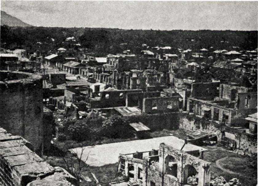
Lipa after bombardment
easy. Leaving the town of Batangas on 24 March, the 188th Infantry task force encountered no serious resistance until, on the evening of the 26th, it reached hill defenses two and a half miles southeast of Lipa held by the Fuji Force’s 86th Airfield Battalion.12 The next day the task force overran the Japanese positions, and during the following night most of the Japanese remaining in the Lipa area withdrew eastward to Mt. Malepunyo, after allegedly setting fire to the town. Actually, American air and artillery bombardments had already battered Lipa beyond recognition. The fire, no matter how started, could have done little additional damage.
The 2nd Cavalry Brigade had moved equally fast.13 The 8th Cavalry took
Santo Tomas on 24 March after a sharp fight; Tanauan fell on the 26th as Japanese resistance throughout the 2nd Brigade’s sector began to collapse. On the 27th, XIV Corps reassigned responsibility for the capture of Lipa to the 1st Cavalry Division,14 and behind close air support that completed the destruction of the town, the 8th Cavalry secured Lipa against little opposition on 29 March. That evening the regiment made contact with patrols of the 188th Infantry task force south of Lipa.
Meanwhile, troops of the 7th Cavalry had advanced about five miles east into the corridor between Mts. Maquiling and Malepunyo. The 1st Cavalry Brigade had been making good progress along the Route 21 corridor on the south shore of Laguna de Bay – it took Los Baños on the 25th, and by the 29th had troops four miles beyond that town. Reconnaissance elements moved across Laguna de Bay in small craft and landed near the southeastern corner of the lake, finding few signs of Japanese. The 1st Cavalry Division and the 188th Infantry task force had completed their shares in the operations to secure the Lipa Corridor and both were ready to swing eastward in strength through the east-west corridors. At Mt. Macolod, however, the 187th Infantry task force was facing a far different situation.
The 187th began its attack at Mt. Macolod on 24 March, but it was not until 1 April that the task force, having encircled the landward sides of the terrain feature, was able to concentrate its entire strength against the main Japanese defenses. Then, down to an effective strength of less than 1,250 men, the task force launched an unsuccessful assault against the Japanese defenders – 300 men holding well-prepared positions in excellent defensive terrain.
There was a hiatus in operations at Mt. Macolod from 3 through 17 April, when the bulk of the 187th Infantry concentrated near Lipa. The regiment renewed the attack on the 18th with reinforcements including a company each of medium tanks, tank destroyers, and 4.2-inch mortars, and over 500 guerrillas. By 21 April the reinforced regiment had overcome the last resistance, completing the job that the 158th RCT had started on 19 March.
Sweeping Eastward
While the 187th Infantry had been reducing the defenses at Mt. Macolod, the rest of XIV Corps had been driving east beyond the Lipa Corridor. Two factors prompted General Griswold to strike east before Mt. Macolod fell. First, General Krueger was putting pressure on the corps to clear the Tayabas Bay section of the northern side of the Visayan Passages quickly. Second, in late March, the Sixth Army commander had directed XI and XIV Corps to gain contact along the eastern shore of Laguna de Bay in order to prevent troops of the Fuji Force from escaping from southern Luzon in order to join the main body of the Shimbu Group.15
Griswold planned to place the emphasis on his drive eastward on his left, the 1st Cavalry Division’s sector, not only because of Krueger’s orders to make contact with XI Corps east of Laguna de Bay but also because the 11th Airborne
Division was, in late March, too scattered and too weak to undertake a concerted attack. As of 30 March the 187th Infantry still had its hands full at Mt Macolod; the 511th Infantry, less 3rd Battalion, was still in Sixth Army Reserve for the Bicol Peninsula operation; and one battalion of the 188th Infantry was still occupied west of Lake Taal. Griswold therefore expected little more from the 11th Airborne Division, at least for the time being, than reconnaissance eastward toward Tayabas Bay from the southern part of Lipa Corridor.16
The new XIV Corps drive started on 30 March as the 12th Cavalry, 1st Cavalry Brigade, struck eastward from the vicinity of Los Baños.17 The regiment moved first to Calauan, seven miles beyond Los Baños, and then marched southward along a secondary road toward San Pablo, at the eastern exit to the east-west corridor between Mts. Maquiling and Malepunyo. Strong Japanese forces held defenses in rocky, bare-sloped hills between Calauan and San Pablo, but in an attack lasting from 1 through 5 April the 12th Cavalry overran those positions, losing 20 men killed and 65 wounded while killing about 140 Japanese. On the last day of this fight the 12th Cavalry made contact with 5th Cavalry patrols coming north from San Pablo, seven miles south of Calauan. The 5th and 7th Cavalry Regiments had fought their way through the Mt. Maquiling-Mt. Malepunyo corridor against stiff but rather disorganized Japanese opposition and had reached San Pablo on 2 April.
On 5 April the 1st Cavalry Brigade and elements of the 8th Cavalry from the 2nd Brigade began patrolling northeast, east, and southeast from San Pablo and Calauan, rounding the southeast corner of Laguna de Bay and probing into the north-south corridor between Mts. Malepunyo and Banahao. Resistance melted away and the cavalrymen encountered only small, disorganized groups of Japanese in the area patrolled. On 6 April the 5th Cavalry made contact with XI Corps troops at the southeastern corner of Laguna de Bay, thus completing one of the XIV Corps tasks.18
Twenty-odd miles to the south, meanwhile, the 11th Airborne Division had accomplished far more than General Griswold had expected of it.19 Interpreting its reconnaissance role in the broadest fashion, the 11th Airborne Division on 1 April had started pushing elements of the 188th Infantry east through the corridor between Mt. Malepunyo and the Batangas Mountains. The leading troops emerged at Tiaong, in the north-south corridor between Mts. Malepunyo and Banahao, on 3 April, and the next day established contact with 5th Cavalry patrols from San Pablo, eight miles to the north. The 188th Infantry next dispatched patrols into the Tayabas Plains region south of
Mt. Banahao, finding the plains free of Japanese and under the control of Filipino guerrillas. When on 6 April troops of the 188th Infantry reached Lucena, the largest town on Tayabas Bay, XIV Corps had finished the job of securing the northern side of the Visayan Passages in its zone.
Mop-up in Southern Luzon
From Lucena, Route 1 ran eastward across the Bondoc Isthmus to Atimonan on Lamon Bay; Route 23 went north from Lucena through the corridor between Mt. Banahao and the Sierra Madre to a junction with Route 21 at Pagsanjan, point of contact between the XI and XIV Corps. On 7 April patrols of the 11th Airborne Division started north from Lucena and 1st Cavalry Division patrols left Pagsanjan on their way south. Making contact on 10 April, the patrols from the two divisions secured the Mt. Banahao-Sierra Madre corridor against negligible resistance.
General Krueger had already directed XIV Corps to continue eastward from the Banahao-Sierra Madre corridor to the shores of Lamon Bay in order to seal off the Bicol Peninsula and make ready to launch a drive southeast through the peninsula to gain contact with the 158th RCT, coming northwest.20 Accordingly, on 11 April a company of the 188th Infantry, meeting little opposition, followed Route 1 across the Bondoc Isthmus to Atimonan. The previous day troops of the 5th Cavalry had reached Lamon Bay at Mauban, eighteen miles northwest of Atimonan. Strategically, the campaign in southern Luzon had ended – the only task still facing XIV Corps was to track down and destroy organized remnants of the Fuji Force.
Before the beginning of April XIV Corps had learned that the Fuji Force was withdrawing into the Mt. Malepunyo hill complex. Indeed, from the inception of operations in southern Luzon, Colonel Fujishige had included such a withdrawal in his plans and had long since begun preparations for a last-ditch stand at Mt. Malepunyo. But Fujishige had expected his Lipa Corridor defenses to hold out longer than they did, and he had not anticipated that his units west of Lake Taal would be cut off. As a result, he had gathered only 4,000 troops at Mt. Malepunyo by early April; of these no more than 1,800 were combat effectives, and he was unable to man many of his prepared defenses. Over 2,000 more troops of the Fuji Force were alive on southern Luzon in early April, but they had little hope of reaching Mt. Malepunyo.21
The forces available to XIV Corps for an attack against Mt. Malepunyo included only the 8th Cavalry, one squadron of the 7th Cavalry, and the 511th Parachute Infantry, released from Sixth Army Reserve on 12 April. The 1st Cavalry Brigade was committed to the thrust into the Bicol Peninsula; the 7th
Cavalry, less one squadron, had moved north of Laguna de Bay to relieve XI Corps units in the Santa Maria Valley; the 187th and 188th Infantry Regiments were needed for mopping up and security missions throughout the rest of southern Luzon.22
During the period 6-12 April patrols had discovered that the principal Fuji Force defenses were located in the northwestern quadrant of the Malepunyo complex, and by the 16th preliminary attacks had compressed resistance into an area around Mt. Mataasna-Bundoc, a peak 2,375 feet high at the northwestern shoulder of the hill mass.23 Further attacks from 17 through 21 April, productive of limited results, served mainly to illustrate the fact that more strength was needed. Accordingly, XIV Corps added the 188th Infantry to the attacking force, simultaneously unifying the command (previously divided between the 511th Infantry and the 2nd Cavalry Brigade) under Headquarters, 11th Airborne Division.
On 27 April, following two days’ bombardment by seven battalions of artillery, the 511th Infantry, the 188th Infantry, the 8th Cavalry, one squadron of the 7th Cavalry, and almost 1,000 attached guerrillas launched a final attack. By coincidence, Colonel Fujishige had started to withdraw his remaining troops eastward to Mt. Banahao that very day, and so found his defensive and withdrawal plans completely upset. By dark on the 30th the combined forces under 11th Airborne Division control had overcome organized resistance at Mt. Malepunyo. Since 6 April Colonel Fujishige had lost almost. 2,500 men killed in the futile defense of the Malepunyo hill mass.
Colonel Fujishige ultimately gathered over 2,000 troops along the upper slopes of Mt. Banahao, including a few men who infiltrated through XIV Corps lines from the region west of Lake Taal, The Fuji Force commander and his remnants were quite content to remain in hiding for the rest of the war, and somehow 1st Cavalry Division and guerrilla patrols failed to discover them. At the end of the war the colonel came down off Mt. Banahao to surrender with nearly 2,000 men.24
Clearing the Smaller Islands
Even before XIV Corps had started into southern Luzon to secure the northern shores of the Visayan Passages, the Eighth Army had instituted its campaign to clear the southern side of San Bernardino Strait – the eastern entrance to the water passes – and to seize the small islands controlling their inner passages. As a matter of fact, operations leading to the clearing of Eighth Army’s portion of the Visayan Passages had begun early in January as part of the deception activities that preceded Sixth
Army’s assault at Lingayen Gulf. At the time, elements of the Western Visayan Task Force from southwestern Mindoro had secured the northern and eastern coasts of Mindoro and had seized Marinduque Island, thirty miles east of Mindoro.25 Troops of the 19th and 21st Infantry Regiments, 24th Division, had executed these early attacks. The first operations Eighth Army undertook in accordance with plans drawn specifically for clearing the Visayan Passages were carried out between mid-February and early March by the Americal Division from bases on Samar Island, north of Leyte.
The Eastern Side of the Inner Passes
Eighth Army’s plan called for the Americal Division, beginning on 19 February, to seize northwestern Samar and adjacent islets for the purpose of securing the southern side of San Bernardino Strait, between Samar and the Bicol Peninsula.26 A small task force built around the 1st Battalion of the division’s 182nd Infantry executed the attack. Landing craft of the 542nd Engineer Boat and Shore Regiment, 2nd Engineer Special Brigade, transported the battalion northward from a base in west-central Samar, and also carried forward a battery of 105-mm. howitzers of the 246th Field Artillery Battalion, Americal Division. The 1st Battalion, 182nd Infantry, landed first on Capul Island, ten miles off Samar’s northwestern coast, during the afternoon of 19 February. (Map X) By the 25th the battalion had secured Capul at the cost of 5 men killed and 10 wounded; the Japanese lost 75 men killed. That the Japanese might have had some thought of employing Capul as a base from which to try to deny San Bernardino Strait to Allied shipping is indicated by the fact that the 1st Battalion, 182nd Infantry, captured three 75-mm. artillery pieces on the island.
On 20 February elements of the 1st Battalion, 182nd, attacked Biri Island and associated islets ten miles off Samar’s northern coast. One infantry company, carried aboard four engineer LCMs, made the assault on Biri, supported by four PT boats and by a single P-38 plane, which strafed the beach before the landing. About 150 yards from shore the LCMs struck a reef, simultaneously encountering intense machine gun and mortar fire from the Japanese on the island. This fire killed or wounded many of the engineer crewmen, but fortunately some of the infantrymen, experienced in amphibious operations, had had sufficient instruction in the operation of LCMs to back the craft off and reassemble at a safe distance.
Meanwhile, a 105-mm. howitzer battery of Americal Division artillery had landed on an islet south of Biri and had set up to bombard the island in support of another assault. Marine Corps SBD’s from a field in southern Samar provided additional support. Striking for a different beach, the 182nd Infantry’s
company made a successful landing during the afternoon. By 23 February, when the Americal Division declared Biri secure, troops of the 182nd Infantry had killed some 70 Japanese on the island. Losses of the American engineers and infantrymen involved totaled approximately 5 killed and 50 wounded.
Following the action at Biri, troops of the 1st Battalion, 182nd Infantry, found other islets off Samar void of Japanese and, against no resistance, established a base on Samar’s northwestern tip. Patrols operating from this base found no Japanese on the north coast, but located a scattered group southward along the west coast. Reinforced by elements of the 1st Filipino Infantry, U.S. Army,27 the 182d’s battalion overran organized resistance on northwestern Samar by 1 March, and on the 4th of the month relinquished responsibility for patrolling in the region to the 1st Filipino Infantry and attached guerrillas. The southern side of San Bernardino Strait was secure.
The Americal Division next moved to other islands in the eastern section of the Visayan Passages. On 3 March troops of the reinforced 1st Battalion, 132nd Infantry, went ashore at Ticao Island, twenty-five miles northwest of Capul Island and only twelve miles from the nearest point of the Bicol Peninsula. Other troops of the 132nd landed the same day at Burias Island, twenty miles northwest of Ticao. The battalion found no Japanese on Ticao but killed 60 of a 100-man garrison on Burias. Guerrillas took over at both islands on 11 March, bringing to an end the Americal Division’s share in the operations to clear the Visayan Passages.
The Western and Central Islands
While the Americal Division was operating at the eastern entrance to the Visayan Passages, units of the 24th Division launched attacks from Mindoro to secure the western exits of the passages. The 24th Division’s first objective was Verde Island, controlling the Verde Island Passage between Mindoro and Luzon and believed to be garrisoned by a Japanese force manning four or five 75-mm. guns.28 A reinforced company of the 1st Battalion, 19th Infantry, landed on Verde Island on 23 February, killed about 20 Japanese, captured three 75-mm. pieces, and returned to Mindoro on the 26th, leaving guerrillas to garrison the island. The guerrillas were unable to overcome the remaining Japanese resistance and during the period 27 February-1 March the 19th Infantry and the 21st Infantry sent troops back to Verde, troops that broke the last opposition on 3 March. Japanese casualties on Verde Island totaled about 80 men killed; the American units lost 6 wounded.
The next objective was the Lubang Islands, fifty-five miles west of Verde and blocking the western entrance to the
Verde Island Passage.29 On 28 February the reinforced 1st Battalion, 21st Infantry, preceded the previous night by a small reconnaissance force, made an unopposed landing on Lubang, the main island of the group, and the Japanese fled into the hilly, jungled interior. On 9 March Company E, 19th Infantry, relieved the 1st Battalion, 21st Infantry, and at the end of the month responsibility for mopping up passed to local guerrillas. For the American forces involved the cost of securing Lubang – the other islands of the group proved void of Japanese – was about 10 men killed and 20 wounded. The Japanese lost 230 killed, among them some who had fled to Lubang as the 158th Infantry, in southern Luzon, had cleared the Calumpan Peninsula between Balayan and Batangas Bays.
The Eighth Army now turned its attention to the central islands of the Visayan Passages – the islands of the Sibuyan Sea, east of Mindoro. Here the first objectives were Romblon, fifty miles east of Mindoro, and Simara, twenty-five miles northwest of Romblon.30 In order to achieve surprise, reinforced companies of the 1st Battalion, 19th Infantry, attempted landings on each island during the night of 11-12 March despite rough seas, pitch dark, and frequent rain squalls. The night landing at Romblon went off successfully, but at Simara poor visibility and the failure of prearranged signals from guerrillas forced postponement until dawn.
Between 12 and 21 March 19th Infantry troops on Simara killed almost 120 Japanese, losing 10 men killed and 20 wounded before leaving the island to guerrillas and moving on to Romblon. The 19th Infantry’s elements overcame the last resistance at Romblon on 3 April, having lost 15 men killed and 35 wounded and having killed 140 Japanese. Guerrillas had already secured the larger islands of Tablas and Sibuyan, respectively west and southeast of Romblon.
The seizure of Romblon and Simara left only Masbate, fifty miles west of Samar, among the major islands of the Visayan Passages still partially under Japanese control.31 The Japanese garrison on Masbate, numbering about 400 troops, was composed mainly of disorganized and ill-equipped survivors of ships sunk during the Japanese attempts to reinforce Leyte in the fall of 1944. Filipino guerrillas, by late March 1945, already controlled much of Masbate, and on the 29th of the month guerrilla reinforcements from Leyte landed on the island behind a short bombardment executed by LCI(G)’s of the U.S. Seventh Fleet. The 2nd Battalion of the 108th Infantry, 40th Division, reached Masbate from Leyte in two echelons on 3 and 7 April. Pursuing scattered Japanese
remnants through Masbate’s hills and jungles, the combined Fil-American forces killed about 120 Japanese and captured 15 by 4 May, when the 108th Infantry’s battalion returned to Leyte. U.S. Army losses on Masbate were approximately 5 men killed and 10 wounded.
The Japanese on Masbate had never posed a real threat to American control of the Visayan Passages, a fact that General Eichelberger, the Eighth Army commander, had recognized as early as 29 March when the guerrilla force from Leyte dispersed the first group of Japanese encountered on the island. Accordingly, on 5 April, Eichelberger reported to General MacArthur that the Eighth Army’s share in the operations to secure the Visayan Passages had been brought to a successful conclusion.32 The next day, in southern Luzon, the 188th Infantry of the 11th Airborne Division made contact with guerrillas along the shores of Tayabas Bay, thus completing operations to secure the northern side of the Visayan Passages east to the Bicol Peninsula. All that remained was for the 158th RCT to clear the Bicol Peninsula, a task the regimental combat team had been about since 1 April.
The Bicol Peninsula Operation
The Preliminaries
Very irregularly shaped and characterized by rough, mountainous terrain of volcanic origin, the Bicol Peninsula stretches southeast from Atimonan on the Lamon Bay shore of the Bondoc Isthmus nearly 170 miles to the tip of the subsidiary Sorsogon Peninsula, Luzon’s most southerly extension.33 The best route of communication in prewar days was a branch of the Manila Railroad that wound its way through the peninsula to Legaspi, forty miles northwest of the Sorsogon Peninsula’s tip. The railroad, however, had been unusable at least since December 1944, when Allied Air Forces planes from Leyte had begun to knock out bridges and destroy rolling stock. Guerrillas had lent a hand to the work of destruction, and had also conducted sabotage operations along Route 1, likewise leading southeast into the Bicol Peninsula from Atimonan. Paved only through a few towns before the war, Route 1 was a two-lane, gravel road over most of its distance. In some of the more rugged parts of the peninsula the highway, which the Japanese had not maintained any too well, narrowed to one lane of gravel or dirt and was subject to washouts and landslides.
The southern shores of the Sorsogon Peninsula form the northern side of San Bernardino Strait. Therefore, Sixth Army and Allied Naval Forces planners gave consideration to proposals to land
the 158th RCT directly on that peninsula, but soon found that the region had few good landing sites, lacked protected anchorages, and had poor overland communications. On the other hand Legaspi Port, on the shores of Albay Gulf two miles east of Legaspi, had good landing beaches, the best port facilities in the Bicol area, and offered access to overland routes to both the Sorsogon Peninsula and the rest of the Bicol Peninsula. Moreover, Albay Gulf provided a large protected anchorage area. Finally, quick seizure of the Legaspi-Legaspi Port area would give the 158th RCT an excellent chance to cut off Japanese forces on the Sorsogon Peninsula and prevent other Japanese from withdrawing into that peninsula in an attempt to maintain control over San Bernardino Strait.
A landing at Legaspi Port, however, would pose certain problems. Sixth Army’s G-2 Section estimated that 1,500 to 2,000 Japanese held strong beach defenses, including heavy artillery, in the Legaspi area or were so deployed as to be within easy striking distance of the shores of Albay Gulf. Intelligence officers also believed that the Japanese maintained mine fields in Albay Gulf and San Bernardino Strait and that other Japanese manned coast defense guns on the Sorsogon Peninsula in order to control the strait, the shortest water route to Albay Gulf from the 158th RCTs staging area in southern Luzon.
The necessity for mine sweeping Albay Gulf and San Bernardino Strait, as well as that for intensive preassault aerial bombardment along the Albay Gulf beaches, had as much influence on General Krueger’s decision to postpone the landing at Legaspi Port as had the necessity for moving the 1st Cavalry Division into southern Luzon before taking the 158th RCT out. Moreover, the bulk of the naval resources in the Pacific was committed to the Central Pacific Area’s invasion of the Ryukyu Islands, beginning in late March; to the support of Eighth Army operations in the southern Philippines, now picking up momentum; and to the supply and reinforcement runs to Luzon. Scant naval means were left over to stage the Bicol Peninsula operation – the Allied Naval Forces had no heavy bombardment ships, nor could the Allied Naval Forces redeploy the necessary mine sweepers from the southern Philippines in time to meet Krueger’s initial target date for the Legaspi assault, 25 March. The task of reducing the Albay Gulf beach defenses devolved upon the Fifth Air Force, but with its other commitments, the Fifth Air Force could not begin large-scale bombardment at Albay Gulf until 23 March.
Allied Naval Forces planners pointed out that a two-day aerial bombardment would be inadequate to assure destruction of known and suspected beach defenses. Unable to face with aplomb the prospect of staging an amphibious assault against defended beaches in the mined and restricted waters of Albay Gulf, the Allied Naval Forces insisted that the Fifth Air Force be given time to obliterate the defenses. Having little choice in the face of all these problems, General Krueger finally set the date for the Legaspi assault at 1 April.
The 158th RCT would stage at Balayan Bay – some cargo and a few attached units would load at Subic Bay – and sail eastward aboard the vessels of Task Group 78.4, Capt. Homer F. McGee,
USN, commanding. The first wave would go ashore in LCVPs, but so few of these craft were available that the 158th RCT would be able to land only two companies abreast in the initial assault. Planners did not think it too risky to send such a small force shoreward, for they expected that the preliminary air and naval bombardment of the beaches would have driven most of the Japanese three to four miles inland. The Japanese, even if so inclined, would probably be unable to organize a counterattack before the rest of the 158th RCT had landed by LCI, LSM, and LST.
Upon assembling ashore, the 1st Battalion, 158th Infantry, would secure the beachhead area, clear the town of Legaspi, and capture a small airstrip a mile north of the town. The 2nd Battalion would make ready to swing south and southeast into the Sorsogon Peninsula; the 3rd Battalion would be in reserve. After securing the beachhead and the Sorsogon Peninsula, the 158th RCT, upon orders from Sixth Army, would strike northwestward up the Bicol Peninsula to gain contact with XIV Corps, which would be moving southeast into the peninsula from southern Luzon. The Sixth Army’s task of clearing the northern side of the Visayan Passages would then be completed.
Sixth Army’s estimate that the Japanese had over 1,500 troops in the Legaspi area was quite accurate.34 The Japanese garrison there included about 1,000 naval troops of the 35th Naval Guard Unit, among whom some 500 men could be counted as trained combat effectives, and 600-700 Japanese Army troops, comprising a reinforced company of the 26th Independent Mixed Regiment and elements of various 4th Air Army ground service units. Around 500 more Japanese, including about 175 Formosan labor troops and some stragglers from Samar, were on the Sorsogon Peninsula. The remaining 1,400 Japanese on the Bicol Peninsula, distributed among three concentrations far northwest of Legaspi, were almost all from the 4th Air Army. Japanese command on the peninsula was divided. The 35th Naval Guard Unit reported to Headquarters, 33rd Naval Special Base Force, on Cebu Island; the Army troops were ostensibly under the direct control of Shimbu Group headquarters, but by 1 April were out of contact with that headquarters.
The Japanese on the Bicol Peninsula were not interested in the defense of the northern shores of the Visayan Passages, and the 4th Air Army troops on the Sorsogon Peninsula had no intention of denying San Bernardino Strait to Allied shipping. The earlier task of the air force units had been to maintain an airstrip that the Allied Air Forces had long since put out of action. Now the principal mission of all Japanese on the Bicol Peninsula was to deny Sixth Army the use of that peninsula as a route of advance against the rear of Shimbu Group’s main body of troops.
Landing at Port Legaspi
The Japanese had established two defensive lines in the Legaspi area. They anchored the first (easterly) line on the south at Mt. Bariway, 2 miles southwest of Legaspi, extending the line north 4 miles along a low ridge to barrio Busay, 3 miles northwest of Legaspi. Busay lay on Route 164, the connecting link between Legaspi Port and Route 1 at Camalig, 6 miles northwest of Legaspi. The 35th Naval Guard Unit defended the second line, which lay in rough, densely jungled ground along the Cituinan Hills south and southeast of Camalig. These hills controlled the approaches to Camalig via Route 164, from the east, and via Route 1 from the south and west.
The Beachhead and the Sorsogon Peninsula
Task Group 78.4 moved through San Bernardino Strait and into Albay Gulf on 1 April without incident. The only opposition to the 158th Infantry’s landing at Legaspi Port was a few rounds of artillery fire from a weapon that a destroyer quickly put out of action.35 Hitting the beach about 1000, the 158th Infantry secured Legaspi Port, Legaspi, and the airstrip north of Legaspi by 1300, finding no Japanese. In the late afternoon troops moved on to Daraga, a mile and a half northwest of Legaspi, and then advanced southward along a secondary road leading to Route 1. About 800 yards south of Daraga Japanese machine gun fire from the Mt. Bariway–Busay Ridge pinned down the 158th’s leading company, and during the following night Japanese infantry surrounded the unit. The next morning,
with the aid of a diversionary attack staged by other elements of the 158th Infantry, the beleaguered company fell back east of Daraga. Meanwhile, patrols had uncovered more Japanese defenses on the ridge line northwest of Daraga. The 158th Infantry had gained firm contact with the Japanese first line of defense.
The 158th RCT was now in a bit of a dilemma. Under orders to clear the Sorsogon Peninsula as quickly as possible, the RCT had found the only overland means of access to that objective, Route 1, blocked by the Japanese defenses south and southwest of Daraga. The RCT would either have to drive off the Japanese there, or it would have to move troops to the Sorsogon Peninsula in a shore-to-shore operation. Brig. Gen. Hartford MacNider, commanding the 158th RCT, could not choose the latter course at this time. First, so few landing craft were available to him that to divert any from general unloading to move even a battalion to the Sorsogon Peninsula might very well create insoluble logistical problems at the Legaspi beachhead. Second, Task Group 78.4 had found no signs of Japanese along the southern shores of the Sorsogon Peninsula as the task group had transited San Bernardino Strait. Third, Eighth Army had already cleared the southern shores of the strait. MacNider therefore felt that he could safely postpone his advance into the Sorsogon Peninsula until such time as the 158th Infantry could use the overland route. Finally, lacking precise information on the strength and extent of the Japanese defenses in the Daraga area, MacNider was loath to divert much strength to the Sorsogon Peninsula. The 158th Infantry, having only 2,000 combat effectives, was some 900 men under authorized strength.
From 2 through 10 April the 158th Infantry fought hard in rough, jungled terrain to overcome the resistance in the Daraga region, the regiment losing 45 men killed and 200 wounded, the Japanese over 500 killed. The battle took considerably longer than General MacNider had anticipated and threatened to cause an undue delay in the occupation of the Sorsogon Peninsula. Therefore, on 6 April, deciding he could wait no longer, he had loaded the Antitank Company, 158th Infantry, on five LCMs of the 592nd Engineer Boat and Shore Regiment and had dispatched it to Bacon, on the north shore of the peninsula. Landing against no opposition, the Antitank Company quickly secured Bacon and the Philippine terminus of the transpacific cable, and then moved on southwest five miles to occupy the town of Sorsogon against no resistance.
By 9 April patrols had discovered that most of the Japanese on the Sorsogon Peninsula had concentrated in low hills north of Bulan, on the peninsula’s southwestern coast. Of insufficient strength to attack this Japanese concentration, the Antitank Company continued patrolling until the 2nd Battalion, 158th Infantry, after an unopposed motor march along Route 1 from Daraga, reached Bulan on 12 April. Supported by a 105-mm. howitzer battery of the 147th Field Artillery and by Fifth Air Force planes, the reinforced 2nd Battalion broke up the Japanese concentration near Bulan by 16 April at the cost of only 6 men wounded. The battalion, which returned to Daraga on the 18th, had killed or found dead over 150 Japanese
in the Bulan region, and had accepted the willing surrender of 155 Formosan labor troops. Guerrillas took over the task of mopping up.
Clearing the Bicol Peninsula
The 158th RCT, acting upon new instructions from Sixth Army, turned its energies to clearing the rest of the Bicol Peninsula and to gaining contact with XIV Corps, which Sixth Army had directed to start driving into the peninsula from southern Luzon.36 Without waiting for the 2nd Battalion to return from the Sorsogon Peninsula, the remainder of the 158th RCT, on 11 April had struck toward Camalig from Daraga, employing Routes 1 and 164 as axes of advance.37 Troops along Route 164 bypassed the Japanese defenses at the Cituinan Hills to the north and entered Camalig unopposed on the afternoon of the 11th.
Since the Japanese in the Cituinan Hills posed a threat to the 158th RCTs line of communication back to Legaspi, General MacNider felt that an advance in strength beyond Camalig before reducing the Cituinan defenses would overreach the bounds of a calculated risk. Accordingly, on 12 April, the 1st and 3rd Battalions, 158th Infantry, attacked into the hills. Slowed by thick jungle and rough terrain almost as much as by the Japanese, and constantly harassed by night attacks, the two battalions had not overrun the defenses when, on 19 April, the 2nd Battalion returned from the Sorsogon Peninsula to join the fight. Progress continued to be painfully slow, and it was not until 28 April that organized Japanese resistance finally collapsed. The task of clearing the Cituinan Hills cost the 158th Infantry approximately 40 men killed and 235 wounded; the Japanese lost almost 700 men killed in the region.
Although the 158th RCT did not know it, the reduction of the Cituinan Hills marked the end of large-scale organized resistance on the Bicol Peninsula, where no more than 1,400 Japanese remained alive as of the end of April. On the 29th the main body of the 158th began moving northwestward from Camalig, following a reinforced company that had reached Iraga, twenty-five miles distant, on 14 April. Rapidly, the regiment overran potentially strong enemy positions in excellent defensive terrain as the remaining Japanese, demoralized, offered only token resistance before melting away into hills on either side of Route 1. On 2 May patrols of the 158th Infantry established contact with the 5th Cavalry at barrio San Agustin, on Route 1 fifteen miles northwest of Iraga.
Troops of the 1st Cavalry Division had begun moving onto the Bicol Peninsula on 12 April, when they relieved units of the 11th Airborne Division at Atimonan.38 The next day the 5th Cavalry struck east from Atimonan and on the 14th reached Calauag, thirty miles
away. All the way from Atimonan to Calauag, Route 1 was in poor condition and beyond Calauag supply movements were almost impossible. The speed of advance now hinged on the speed of engineer road and bridge repairs. Accordingly, the 5th Cavalry secured the eastern shore of Tayabas Bay and set up a supply point at the bay’s northeastern corner so that LCMs could bring forward ammunition, food, and equipment from Batangas. Beginning on 27 April the main body of the regiment began moving by LCM across Ragay Gulf, the first indentation on the south coast of the Bicol Peninsula beyond Tayabas Bay. On the 28th the regiment, encountering no resistance, moved from the shores of Ragay Gulf to Naga, eight miles northwest of barrio San Agustin, and had no trouble marching south to meet the 158th Infantry.
Guerrillas had informed XIV Corps, which acquired control of the 158th RCT on 22 April, that a Japanese force of some 2,500 men was dug in along the slopes of Mt. Isarog, an extinct volcano centering eight miles northeast of San Agustin. This report the 5th Cavalry and 158th Infantry proved false in a series of patrol actions between 2 and 15 May. The next day, the 16th, General MacNider radioed to General Griswold that the Bicol Peninsula was secure and that no signs of organized Japanese resistance remained.
The two regiments continued patrolling for some weeks until, on 6 June, the 5th Cavalry returned to southern Luzon. The 158th RCT busied itself with the problem of reorganizing and equipping guerrilla forces and in mid-June turned over responsibility for further mopping up to the Filipinos. To that time the operations to clear the Bicol Peninsula had cost the U.S. Army units involved approximately 95 men killed and 475 wounded. The Japanese had lost over 2,800 killed and 565 captured, including 350 Formosan labor troops whom the Japanese Army had left to fend for themselves.
The strategic goal of the Bicol Peninsula operation – to finish clearing the Visayan Passages – had been realized on 2 May with the contact between the 158th Infantry and the 5th Cavalry at San Agustin. The final patrolling and mopping up the two regiments undertook had provided the necessary capstones to the combined Sixth Army-Eighth Army campaign to assure the safety of the Visayan Passages for Allied shipping.
Undertaken against generally ill-equipped, poorly fed, second-class and third-class Japanese forces, the campaign had yet proved costly. U.S. Army units involved had lost roughly 300 men killed and 1,130 wounded; the Japanese, to mid-June, had lost at least 8,125 killed and nearly 750 captured. The campaign had proved logistically more important than it had strategically or tactically. Sixth Army, Eighth Army, and Allied Naval Forces had not found the Japanese coast artillery and mine fields they had expected to discover emplaced so as to endanger Allied shipping in the passages. Nevertheless, General MacArthur would ultimately have had to direct his subordinate echelons to eliminate the Japanese from southern Luzon, the Bicol Peninsula, northern Samar, and the islands of the inner passages if for no other reason than to liberate from the Japanese yoke the many thousands of Filipino inhabitants of those regions and to restore to the Filipinos their lawful government.
Blank page