Part III: Northern Solomons Operations
Blank page
Chapter 1: Continuing the Pressure
Strategic Requirements1
There was little time for extended rest for Allied sea, air, and ground forces after the final Central Solomons action in October. As early as the previous March, a decision had been made that the Northern Solomons would be the target next after New Georgia; and by the time Munda field was operational under Allied control, plans for the seizure of a beachhead in the Shortlands-Choiseul-Bougainville area were in the final stages. In effect, ComSoPac operations of September and October were the last act to the successful completion of the Central Solomons campaign as well as the overture to the forthcoming Bougainville attack.
The importance of Rabaul had not diminished during the long period involved in taking New Georgia, but the events of the last six months had put the Japanese stronghold on New Britain in a new light. In 1942 there had been no doubt that Rabaul would have to be physically eliminated to insure an inviolate hold on the Southwest-South Pacific area. By mid-1943, there was a growing realization that the enemy air and naval base might not have to be erased by force, that neutralization would serve the Allied cause as well. Concurrent with this shift in thinking was a proposal that the main Allied effort be directed through the scattered islands of the Central Pacific instead of through the larger land masses of New Guinea and the Philippines.
Both concepts had many high-ranking proponents. The divergent views resulted in some open disagreement among the many strong-willed commanders and staff officers responsible for the Allies’ operational strategy, but the eventual solution was born of the imagination and experience of all, and there was no further dispute once the course of action had been charted. The actual decision to strangle Rabaul by air instead of capturing it was made by the Combined Chiefs of Staff upon recommendation of the JCS. The CCS conference at Quebec in August also directed that the advance through the
Southwest-South Pacific by General MacArthur and Admiral Halsey was to continue while Admiral Nimitz aimed a new offensive along the Central Pacific axis. The idea of two campaigns was an effective compromise. Although some realignment of forces was necessary, an extensive shuffle of troops or shipping from either theater would not be required; and a coordinated attack along two fronts would have the advantage of keeping Japanese defenses off balance and committed over a wide area.
Throughout this evaluation period, General MacArthur held fast to the original ELKTON concept. On the 4th of September, the VIIPhibFor (Admiral Barbey’s command) landed SoWestPac troops on the Huon Peninsula of New Guinea to set the stage for eventual passage of MacArthur’s forces through the Vitiaz-Dampier Straits. Success of the venture, though, depended upon insurance in the form of air bases within fighter plane distance of Rabaul. Thus, MacArthur’s continued surge toward the capture of Salamaua, Lae, and Finschhafen virtually dictated establishment of Allied air facilities in the Northern Solomons by November or December of 1943. Plans for a landing in the Bougainville vicinity, temporarily shelved while other strategic concepts were being examined, were once again restored to the status of a full-scale operation by MacArthur’s insistence.
The exact location for such an undertaking had been the cause for considerable discussion and reconnaissance by Halsey’s staff. Several islands had been proposed as targets but closer examination eliminated them. The island of Choiseul was little regarded as a major landing site because of two factors: it was not within fighter escort range of New Britain; and MacArthur was of the opinion that an assault on Choiseul did not directly threaten Rabaul. Buka, the small island appendage to northern Bougainville, was too far from Allied air bases for a landing there to be protected adequately. Initial plans to seize the southern end of Bougainville were canceled because the airfields at Kahili and Kara were too strongly protected to attack with the forces then available to Halsey. With the drawn-out campaign on Munda still fresh in his mind, ComSoPac was reluctant to mix with the Japanese in a prolonged struggle that would take too many lives and too much time without paying immediate dividends.
After some deliberation, Halsey proposed that the SoPac forces seize the Shortland Islands (Ballale and Faisi) as airfield sites and then interdict Kahili and Kara with artillery fire as the Rendova forces did at Munda. This move would put Allied air support within fighter range of Rabaul. MacArthur, willing to settle for any action which would help him realize his expressed ambition to return to the Philippines, approved this concept. But later reconnaissance revealed that the Shortlands had no beaches big enough or good enough over which an amphibious assault could be staged, and that airfield sites were limited.
Halsey’s top-echelon planners, abandoning the Shortlands idea,2 on 6 September advanced another plan to seize the
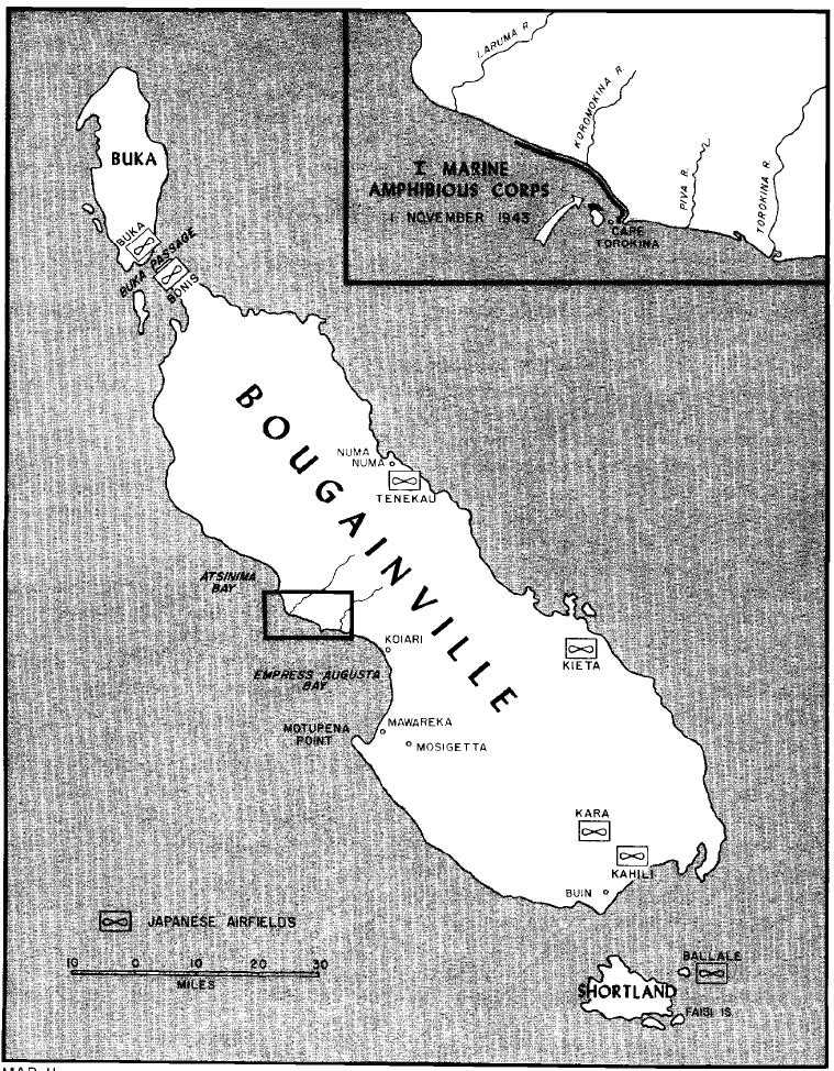
Map 11: Bougainville
Treasury Islands and Choiseul as radar and PT bases and jumping-off points for further operations against Bougainville. MacArthur, however, had concluded that the original intentions of ELKTON called for a. landing directly on Bougainville and that the interests of the JCS-approved plan could best be executed by an early operation (within the next few months) against Bougainville. MacArthur indicated that any target Halsey selected would be acceptable, but that a decision must be reached soon.
Kieta, on the northeastern coast of Bougainville, was a protected anchorage with an airfield close by; but an assault on Kieta involved long approaches by sea—and the Allied shipping shortage was critical. Kieta was too close to Choiseul, moreover, and that island would have to be attacked as a preliminary measure to protect the landing on Bougainville. Empress Augusta Bay, on the west coast, at first glance had little to recommend it as a landing site. The beaches along the bay were exposed to wind and waves and held no sheltered anchorage for the amphibious shipping required for such an operation. The terrain inland was known to be swampy, heavily timbered, and with few routes of communication. On the other hand, the enemy had apparently dismissed this area as a probable landing spot and the bay was only lightly defended. As late as 17 September, the Allies stood at a figurative crossroads, undecided about which fork in the road to take.
Five days later, on 22 September, Halsey announced a decision that canceled all previous plans and alerted his forces for one of two alternate courses of action: seize and hold the Treasury Islands and northern Empress Augusta Bay area on Bougainville as airfield sites; or, as a second course, seize and hold the Treasury Islands and the Choiseul Bay area as advance radar points, torpedo boat anchorages, and a staging base for landing craft before moving on to construct an airfield on the east coast of Bougainville later in the year. The final decision depended upon last-minute reconnaissance efforts.
Spotlight on Bougainville3
For the Japanese, the conviction that Bougainville was the ultimate Allied objective in the Northern Solomons was hardly a random guess. Lying in a position athwart the northern entrance to The Slot, Bougainville’s big bulk dominated the rest of the Solomons chain. By virtue of this ideal geographic location, the island served the Japanese as an advanced supply and refueling base for most of the sea and air operations against the Allies at Guadalcanal and in the Central Solomons. Here, too, were staged the infantry replacements destined for combat or garrison duty on other South Pacific islands. No less than six major airfields and a number of naval operating bases were established by the Japanese on Buka, Bougainville, and the Shortlands to help guard the outer defenses of the airfields and Simpson Harbor at Rabaul. Easily supported by air bases on New Britain, New Ireland,
and Truk—points outside the range of most Allied land-based planes—Bougainville was also under the umbrella of naval support from Rabaul and Truk. In short, the Allies needed Bougainville for further operations against Rabaul; the Japanese needed Bougainville to defend Rabaul. Viewed from either camp, the island was a priority possession.
Bougainville was never a part of the British Solomon Islands protectorate. German expansion had claimed the island in 1899, some 130 years after its belated discovery by the French explorer whose name it bears. Mandated to Australia after World War I, the island still was influenced by German missionaries, for the Bougainville natives in 1943 were recognized as hostile to the Allies and considerably more friendly to the Japanese.4 Some 40,000 natives were on the island, gathered mainly in small villages of less than 200. Energetic and industrious, they provided an adequate labor force for the large plantations which, before the Japanese occupation, were owned by European companies.5
The island is the largest of the Solomons group. Nearly 30 miles in width, Bougainville is divided down the center by mountain ranges which extend nearly the entire 125-mile length of the island. The northern Emperor range is capped by the distinctive 10,171-foot peak, Mt. Balbi. The second range, Crown Prince, is less rugged and settles gradually into a broad, widening plain at the southern end of the island. This area has the best anchorages and the biggest plantations. The two coastlines, east and west, are markedly different. The eastern side of the mountain ranges slopes to a fairly open plain with good beach areas. The western side, however, is deeply etched by rushing mountain streams which carry silt into a swampy, alluvial plain bordering the coastline. The characteristic result is a series of deep valleys ending in swamps and sand bars cut by meandering waterways and sluggish rivers of varying depths. This soggy fringe area, covered with tall marsh grass and bamboo-like growth, is trapped between mountains and the sea by a grey-black beach strip which seldom exceeds 15 yards in width.
The island interior is enveloped by a dense rain forest and choking jungle growth which combine with the rugged mountain ranges to discourage overland exploration. A number of good trails traverse the more populated areas in the south and east, but only a few native tracks venture across the inhospitable interior. One path cuts across the mountains from Numa Numa to Empress Augusta Bay where it connects with the East-West trail. This path joins the western villages of Mawareka and Mosigetta to Buin in the south. Fairly wide and cleared, the East-West trail skirts the coastal swamps and can be traveled most of the year.
Although the Japanese had occupied the island since March 1942, only those facilities necessary to maintain the war in the Solomons had been constructed initially. In time, four airfields were in operation, two at each end of the island, and additional troops were stationed on Bougainville. Scant attention, however, was given to the island region between the major airfields. For more than a year, Japanese activity was restricted largely to the Buin area in the south and the Buka-Bonis
passage in the north.6 There was little overland travel. Barges moving along the coastline served most of the transportation needs. As a result, few roads were improved and in the later defense of the island, this proved an important oversight.
Australian coastwatchers and a few friendly natives maintained observation posts on the southern part of the island until the summer months of 1943. Then aggressive Japanese patrols, assisted by unfriendly native guides, forced the Allied scouts to abandon their radio equipment and withdraw to the interior.7 As a result, military information about the island and its defenders was cut off abruptly just when it became most needed.
Intelligence estimates on the number of Japanese soldiers and sailors in the area varied widely. Interceptions of radio messages provided most of the information on troop dispositions, and this intelligence was augmented and checked by enemy documents captured in the Central Solomons and by prisoner of war interrogations. Allied guesses placed the total number of defenders in the vicinity at 98,000—2,000 at Choiseul, 35,000 or more at Bougainville and the Shortlands, 5,000 at New Ireland, and the remaining 56,000 at Rabaul. The estimates on the strength of the Bougainville forces, based on order of battle information from prisoners, ranged between 35,000 and 44,000. The biggest concentration of defenders was in the southern part of the island, where an estimated 17,000 soldiers of the Seventeenth Army were headquartered. Another 5,000 troops were believed to be in the Buka-Bonis area, with a similar number at Kieta. The only known enemy concentration on the west coast was at Mosigetta, where about 1,000 Japanese—believed to be laborers—were engaged in cultivating the extensive rice fields of that coast. Less than 300 troops were estimated to be in the Cape Torokina vicinity of Empress Augusta Bay. The Shortlands defense force was estimated at 3,000 to 6,000, most of these naval personnel from Eighth Fleet headquarters and SNLF units.
Postwar records of the Japanese indicate that the Allied estimates were close. The Buin area actually had about 15,000 troops of the Seventeenth Army and 6,800 of the Eighth Fleet headquarters and base force personnel, primarily for defense of Kahili and Kara airfields. About 5,000 men were deployed in the Shortlands. The airfield on Ballale was defended entirely by naval personnel with seacoast artillery.
The troop dispositions were in line with the enemy conception of the plans of the Allies. After Guadalcanal was evacuated, and the Japanese became aware of the responsibility of defending what they had so easily grabbed, the Shortland Bay area was decided upon as the strategic key in the defense of the Northern Solomons. Accordingly, the southern part of Bougainville and the Shortland Islands received first priority in troop allotments. At that early date, the enemy believed that any Allied offensive would be directed against the airfields in the southern portion of the island with a possible subsidiary action in the Buka area. Troop strength elsewhere was proportionate to
the Japanese estimate of the Allies’ ability to hit each area. Bougainville’s defense was based on the premise that a landing anywhere on the island could be met by a transfer of ground troops and a counterlanding by an amphibious group.
Responsible for the defense of Bougainville and the adjacent islands was an old adversary, Lieutenant General Haruyoshi Hyakutake,8 who had commanded the Japanese forces on Guadalcanal. The general had apparently lost little prestige with the Imperial Staff through the defeat, for he was still in command of the Seventeenth Army. His forces, however, had not shared his fortune. The 2nd Division was almost wiped out at Guadalcanal, and the 38th Division had lost heavily at Guadalcanal and New Georgia. His sole remaining division, the 6th, commanded by Lieutenant General Masatane Kanda, was still in fighting shape. Two regiments, the 23rd and 45th, were near top-strength, but the third regiment of the division, the 13th Infantry. had been badly mauled in the Central Solomons. To this division, Hyakutake could add detachments of SNLF units, plus the scattered remnants of other infantry regiments which were trickling into Bougainville after the withdrawal from the Central Solomons.
The Allied estimate of the Japanese ships in the immediate vicinity (Buka, Bougainville) was 2 cruisers, 8 to 10 destroyers, 21 personnel transports, and 12 submarines, plus a variety of smaller craft. The Imperial Navy also had a healthy reserve of warships at Truk and Rabaul. Air support in the Northern Solomons was believed to be about 160 fighters, 120 dive bombers, 120 medium bombers, and 39 float planes.9
There were definite signs in September that the Japanese expected an assault on Bougainville. Despite increasing air attrition, plane strength at Buka, Kara, Kahili, and Ballale remained fairly steady as the Japanese replaced their losses. Airfields were improved and expanded despite steady pounding by Allied bombers, and supply routes to the island were maintained in spite of losses incurred through harassment by Allied patrol bombers and torpedo boats. In late October, as the Allies completed their plans for attack, even the long-neglected west coast of Bougainville was given some attention by the Japanese. Intelligence photos for the first time revealed evidence of military activity near Empress Augusta Bay. Some minor construction with a few scattered defensive installations were discovered behind Cape Torokina, but since the improvements were limited and no additional troops appeared to have been moved into the area, the Allies remained convinced that the Japanese had not altered their basic defensive plans and that they had not awakened to the dangers inherent in an undefended coastline.
Halsey’s Decision10
Before a final decision was made on the direction of the SoPac attack,
reconnaissance efforts to obtain every possible scrap of information and intelligence about the various projected landing sites continued. As at Guadalcanal and New Georgia, prior knowledge of the Bougainville area was limited to sketchy reports from former residents, planters, medical officers, schooner masters, and missionaries. Although these reports were valuable in regard to general conditions and physical improvements in certain areas, few facts of military significance were obtained. As before, personal reconnaissance by trained observers was required to accumulate the necessary detailed geographic and hydrographic information upon which to base a decision. The first intelligence efforts covered the entire Northern Solomons—Santa Isabel, Choiseul, the Treasurys, Shortlands, and Bougainville. Later, as some islands were eliminated and the choice of targets narrowed to either the east or west coast of Bougainville, reconnaissance activities were concentrated on the Kieta and Empress Augusta Bay areas.
Initial combat intelligence was gathered from air reconnaissance and submarine patrols. Aerial photography was limited because of unfavorable weather, enemy air interference, and lack of fighter plane escorts. Submarines moved in close to the island to shoot pictures through raised periscopes, but this practice was hazardous since the outdated hydrographic charts then available failed to show the exact location of dangerous coral outcroppings and reefs known to exist. Besides, the pictures did not reveal much except a good profile shot of Bougainville’s rugged peaks. In time, patrols from submarines, torpedo boats, and seaplanes slipped ashore to scout various areas, and the information gained from physical reconnaissance and personal observation was added to ComSoPac’s growing file.
Two patrols, dispatched to Bougainville in September after Halsey announced his two-part alert, helped the SoPac commander decide on the final choice of objectives. One Marine-Navy team, with an Australian officer and four natives as guides, remained four days in the Kieta vicinity, prowling the northeast coast of the island during the night and spending the daylight hours underwater in the submarine USS Gato. Considerable Japanese troop activity was observed; and despite several close scrapes from patrolling enemy barges, the group measured beach distances, took depth soundings, and scouted the area inland. On 28 September, the patrol boarded the submarine for the last time and returned to Guadalcanal. The patrol’s report was generally unfavorable,11 indicating that the harbor had many reefs and coral outcroppings, and that the area inland was not suitable for airfields since the Japanese had apparently given up on Kieta.
Another patrol similarly organized landed from the submarine USS Guardfish near the Laruma River in north Empress Augusta Bay. Here the terrain was found to be fairly solid with thick bush and a dense rain forest inland. Reluctant to arouse the Japanese to any Allied intentions, the patrol studied Cape Torokina through binoculars and took photographs through telescopic lens. The long-range examination revealed a narrow beach strip some 10,000 yards long with the expected coastal swamps inland. Tidal range in the bay was moderate, about 3½ feet. A coconut
grove on Cape Torokina looked like a favorable spot for an airfield, the patrol decided, since the area appeared dry enough and long enough to support a fighter plane strip. Unable to obtain a soil sample of the area, the patrol did the next best thing and brought back soil from a similar area. The scouts then turned back to the Laruma river and headed into the bush in a wide circle that ended four days later in a rendezvous with the Guardfish in Atsinima Bay, some distance to the north. The only enemy sighted were a lone sentry on post near the Laruma river, and a number of Japanese reconnaissance planes flying patrol duty over Empress Augusta Bay beaches.12
The endeavor had one big dividend. While waiting for the patrol, the submarine commander checked his position and discovered that the navigation chart then in use was about seven miles in error in its location of Cape Torokina. Undetected, this one factor might well have jeopardized any future operations. Too, the soil sample returned by the patrol was declared favorable for construction of an airfield.
The prospect of landing in a lightly defended area close to an acceptable airfield site appealed to Halsey and his SoPac planners. To confirm the patrol’s recommendation, a number of low-level aerial reconnaissance flights were made by IMAC staff members. Their quick glimpses of the Cape Torokina area convinced them that the operation could be a success. On 1 October, Halsey notified MacArthur that Cape Torokina was the main objective and that D-Day would be 1 November. The SoWesPac commander expressed his complete agreement with this decision.13
After 12 days of planning, Halsey’s ComSoPac headquarters issued the orders which outlined the missions of the sea, air, and ground forces under the admiral’s command. Specifically, ComSoPac directed the III Amphibious Force to seize and hold (on D-minus five days) the Treasury Islands as a staging area and advanced naval base, prior to establishing a beachhead on D-Day in the northern Empress Augusta Bay area for construction of airfields and another advanced naval base. The ultimate aim was strangulation of enemy operations in south Bougainville and preparations for further offensives against Rabaul.
Code names selected by ComSoPac for the planning phases were DIPPER, denoting the entire Northern Solomons operation, and CHERRYBLOSSOM, the Empress Augusta Bay area. The Treasury Islands phase of the operation was labeled GOODTIME. Later the code name DIPPER was applied to the Bougainville operation and the island, while the Treasury Islands landing retained the GOODTIME designation.
Selection of Cape Torokina as a landing site despite its disadvantages was tactically and logistically sound. The location fitted well into the plans for neutralization of Rabaul by air, and a beachhead on the western side of Bougainville made logistic support much easier. Moreover, the attack was aimed at a weak point in the Japanese defenses, thus avoiding a direct assault on main enemy defenses in the southern and eastern coasts of the island. Success of the venture depended upon the
ability of the Allies to beat back any determined sea and air offensive by the Japanese during the critical stages of landing and establishing a beachhead. ComSoPac planners admitted that a strong enemy reaction was highly probable, but this threat was accepted as a calculated risk. The projected operation was “no better demonstration of the firmly held, but at times sorely tried, belief in the Allied superiority over the enemy in the South Pacific.”14
Less obvious in the choice of Empress Augusta Bay was the fact that the Cape Torokina plain, bordered by the natural obstacles of the Laruma River to the northwest, the mountains inland, and the Torokina river to the southeast, fell into an ideal defensive area about six miles deep and eight miles long which could be defended by the Allied forces then available. The location, too, was believed so isolated from known Japanese dispositions by the nature of the island’s terrain that at least three months would be required before a strong force moving overland could seriously threaten the beachhead. In short, large bodies of reinforcing enemy troops could come to the area only from the sea, and the Third Fleet felt confident that it could handle that threat. The Allies had no desire to capture the entire island—the size of Bougainville and the rough terrain precluded such ambitions—but two infantry divisions could hold the Cape Torokina area against any enemy forces in the immediate area or likely reinforcements.
These facts did little to increase enthusiasm for such bold plans. Sentiment was mixed—some optimism, some hesitation, some reluctance—but with D-Day less than a month away, all hands bent to the task of preparing for the assault on the Treasurys and Bougainville.
Amphibious Planning15
The planning team that directed the preparations for the Bougainville operation was essentially the same command lineup that outlined the New Georgia attack—with one important change. As before, Admiral Halsey retained personal control of the proceedings, dividing his attention between completion of the Central Solomons campaign and the development of a new operation. From his headquarters in Noumea, Halsey coordinated the planning activities of Admiral Fitch on Espiritu Santo and Admiral Wilkinson and General Harmon on Guadalcanal. A new member of the planning staff was Lieutenant General Alexander A. Vandegrift, who had replaced General Vogel as commanding general of the I Marine Amphibious Corps, the counterpart to the Army’s ground force command under Harmon. As such, Vandegrift held administrative responsibility over practically all Marine Corps personnel in the South Pacific, the exceptions being land-based air units under General Mitchell’s command (Marine Air, South Pacific) and ships’ detachments. The IMAC staff had not participated in the New Georgia planning since the bulk of the troops were to be furnished
by Griswold’s XIV Corps, but Halsey’s first planning directive designated the Northern Solomons as an IMAC assignment. As a result, the Marine command became tactical as well as administrative.
Vandegrift, who had won a Medal of Honor for his leadership of the 1st Marine Division at Guadalcanal, was the first of three IMAC commanders to participate in the Bougainville operation. After completing preliminary plans, Vandegrift was relieved by Major General Charles D. Barrett on 15 September and was en route to the United States to become the 18th Commandant of the Marine Corps when his return was abruptly sidetracked.16 General Barrett had suffered a cerebral hemorrhage in an accidental fall, and his untimely death left IMAC planning in midair. The operational order for IMAC’s part in the seizure of the Treasurys and Bougainville had been drafted before Barrett’s death, and Vandegrift resumed command on 18 October in time to sign the completed order17—noting, meanwhile, that the entire concept of the operation had changed within the space of one month.18 Vandegrift completed the planning and witnessed the start of the operation before relinquishing command of IMAC to Major General Roy S. Geiger on 9 November, well after the success of the beachhead was assured.
Even as the Northern Solomons planning shifted through a number of changes before the final draft emerged, so did the task organization assigned to the IMAC landing force. Of the three Marine divisions in the Pacific in 1943, only the 3rd was available for the Bougainville operation. The 1st Marine Division was scheduled by MacArthur to spearhead the Cape Gloucester beachhead on New Britain, and the 2nd Marine Division had been shifted to the Central Pacific for the Gilbert Islands assault. To augment the 3rd Marine Division and IMAC troops, the Army’s 25th Division and the 1st Marine Raider Regiment were tentatively assigned to the Bougainville venture; but, as the Central Solomons campaign wore on, both organizations were committed to action far beyond original plans, with the result that neither was available for the Northern Solomons.
A number of provisional units were formed from scattered battalions, and these—with the later addition of the 37th Infantry Division—were assigned to IMAC. Vandegrift’s command eventually included his own headquarters and corps troops, the 3rd Marine Division, the Army’s 37th Division, the 8th Brigade Group of the 3rd New Zealand Division, the 3rd Defense Battalion, the 2nd Marine Raider Regiment (Provisional), the 1st Marine Parachute Regiment, the Army’s 190th Coast Artillery Regiment (Antiaircraft), and varied naval small craft, construction, and communication units. The Marine parachute regiment, then on Vella Lavella, was designated the corps’ reserve force. In area reserve were several coast
artillery battalions on Guadalcanal and the Army’s Americal Division, then in the Fiji Islands. This latter division, however, could be committed only on Halsey’s approval.
After the target had been defined in late September, Halsey established his operational chain of command with his amphibious force commander, Admiral Wilkinson, in charge of the entire Bougainville-Treasurys expedition. Wilkinson maintained control of Task Force 31 (III Amphibious Force) with the ground force and transport groups as subordinate commands. As directed by Halsey, Wilkinson would continue to command all forces afloat and ashore until the landing force commander was ashore and had indicated that he was able to take command of the ground forces.19 The IMAC commander, at first Barrett and then Vandegrift, was responsible for the scheme of maneuver ashore at both Cape Torokina and the Treasurys, and was to exercise command over all units ashore, whether Allied forces, Marine Corps, Army, Navy, or ground echelons of air units. As at New Georgia, the actual employment of aerial support was to be under the operational control of air officers. This air echelon, Commander Aircraft Northern Solomons (ComAirNorSols) was a subordinate command of ComAirSols and was under the direction of Marine Brigadier General Field Harris. His tasks included the responsibility for active air defense of the Bougainville region (Torokina and the Treasurys) as well as operational control of all supporting aircraft entering this region. Harris’ responsibilities also included establishment of an air warning system for both Torokina and the Treasurys and organization of air support control procedures for both areas.
For the Treasury Islands phase of the operation, Wilkinson added another echelon to his command, dividing his task force into a Northern Force for the Empress Augusta Bay landings and a Southern Force (Task Force 31.1) for the diversionary landings. Wilkinson retained command of the Northern Force (actually, a name designating the main units of Task Force 31) and placed Admiral Fort in command of the Southern Force. The Treasurys landing force, comprising mostly troops from the 8th Brigade Group of the 3rd New Zealand Division, was commanded by Brigadier R. A. Row, under the general direction of the IMAC commander.20
By mid-October, all subordinate echelons of Task Force 31 and IMAC had issued operational orders, and the diverse sea and air elements under Third Fleet command had been assigned general missions in support of Wilkinson’s task force in the Bougainville-Treasurys venture. Land-based air units of ComAirSols
(Task Force 33) were ordered to continue the general missions of reconnaissance and destruction of enemy ships and aircraft with the added duties of providing air cover and support for the land and sea forces involved in the Northern Solomons assault. Rear Admiral Frederick C. Sherman’s carriers (Task Force 38) were directed to support the expedition by air strikes at Buka and Bonis airfields which were beyond the effective range of fighter planes from the now-completed airfields in the New Georgia area.
Cruisers and destroyers of Rear Admiral Merrill’s Task Force 39 were to furnish protection for the amphibious force as well as bombard enemy installations in the Buka-Bonis and Shortlands area before the operation. Task Force 72, the submarines under the command of Captain James Fife, Jr., was to carry out offensive reconnaissance missions north of the Bougainville area.
Final planning for the actual assaults at Cape Torokina and the Treasurys was facilitated by the move of IMAC headquarters from Noumea to Guadalcanal, where the amphibious forces were in training. Vandegrift’s command post was established in a coconut grove near Tetere, just a short distance from the headquarters of the IIIPhibFor and the 3rd Marine Division bivouac area. The close proximity of the three major heaquarters responsible for coordinating the efforts of the forces involved eased considerably the problems that arose during the last weeks of preparation. And problems arose—many of them. In effect, the Northern Solomons operations had become two operations—each one with resultant problems of transportation, reinforcement, and resupply.
Tactical limitations in launching the Bougainville operation became apparent early.21 In fact, the entire venture bore the title of “Shoestring No. 2,” a reference to the general paucity of means which characterized the Guadalcanal operation in 1942.22 Early in August, Halsey had reviewed the shipping situation in the South Pacific and estimated that he would need six additional troopships to complete preparations for the next operation, declaring that at least 14 APAs and 6 AKAs would be required from D minus 15 to D plus 5 for the assault on Bougainville.23 Other commitments, particularly the Central Pacific campaign, had claimed all but eight APAs and four AKAs from the SoPac area; and this limited amount of amphibious shipping was the specter which haunted the Bougainville preparations. The acute shortage seriously restricted the number of troops and supplies that could be transported in the initial assault and prohibited a rapid buildup at the objective. Further, any loss of ships could not be replaced immediately; and, since these 12 ships were a bare minimum for transporting an assault division with the necessary artillery, air service personnel, engineers, and heavy equipment to construct and maintain an airfield, the sinking of any of these ships
during the beachhead phase would seriously threaten the entire operation. The definite possibility of quick and effective air retaliation by the enemy prompted a decision by Wilkinson that the slow-moving LSTs under his command would not be risked during the early phases of the operation.
The glaring contrast between the conduct of the Guadalcanal landing and the New Georgia operation was emphasized in the concept of the Bougainville assault. Vandegrift had the experience and tactical foresight required for such an operation. In Wilkinson he found a partner with a good grasp of amphibious support of operations ashore. Together the two commanders were a good team, and the plans they evolved were practical applications of the available means to the situation. Guadalcanal had been an assault followed by the establishment of a protective perimeter thrown about a captured airfield. The Japanese had dashed themselves against this perimeter, suffering ruinous casualties in the process. New Georgia, however, had been the reverse—a landing, then a protracted overland attack that had been a tiring, bloody smash against a Japanese perimeter. Given these examples, Vandegrift and Wilkinson were determined that the tactical errors of New Georgia would not be repeated. At Bougainville, the Marines would land first, establish and expand a beachhead, and—when the fighting widened into extended land operations—the Army would take over. Airfield construction would commence upon landing, with completion of air strips expected in time to help defend against any determined assault by the Japanese.
In order to take advantage of the extensive stretch of beach north of Cape Torokina, a simultaneous landing of all troops and supplies over multiple beaches was scheduled. This would allow the vitally important ships to drop anchor, unload, and depart without undue delay in the objective area. To further reduce unloading time, all cargo ships would be restricted to short loads, and assault troops would be diverted to hasten the unloading activities. Twelve beaches were to be employed in the assault, eleven extending northwest from Cape Torokina toward the Laruma River and the twelfth located on the northern (inner) shoreline of Puruata Island, the larger of two islets lying off Cape Torokina.
Three assault units of four landing teams each were to land abreast over these 12 beaches. One task unit was to land in the right sector of the beach area with a second task unit landing in the left sector. The third task unit was to be divided, two landing teams landing in each sector. Each infantry unit was to overrun any enemy defenses and seize a broad but shallow beachhead. Reconnaissance was to be started immediately to the front and flanks, while unloading was completed. Beach and antiaircraft defenses were to be prepared immediately to insure protection from a possible enemy counterlanding or the expected enemy air attacks.
Barring unforeseen difficulties, at least 13,900 men would go ashore in the D-Day landings at Cape Torokina. Unloading time for the troops and the 6,200 tons of embarked supplies and equipment was set at no more than six hours. No floating reserve for the Bougainville assault was planned, since the enemy situation ashore did not seem to warrant this risk of
embarked troops and supplies. Initial plans called for the beachhead to be reinforced and resupplied by five LST echelons five days apart, each echelon bringing in another 3,000 troops and 5,500 tons of cargo. Vandegrift, upon resumption of the IMAC command, objected to this slow buildup and insisted that reinforcement of the beachhead proceed at an accelerated rate. He proposed that the 37th Division follow the 3rd Division ashore no later than D plus 7.24 This change in plans was agreed upon. The IMAC general also assumed responsibility for beachhead logistics, and, in planning the rapid unloading sequence, Vandegrift assigned about one-half of his combat Marines the temporary task of getting supplies ashore. During the initial stages, these Marines would work in the holds of the ships and on the beach as a shore party before returning to their units for combat operations.
Such preparations were not idle gestures. Once ashore, the IMAC troops faced the prospect of having an extremely tenuous supply chain cut behind them by enemy counteractions. To forestall any emergency later, Wilkinson decided to use all available ships in supply operations before the landing. Accordingly, an attempt was made to bring a 30-day level of all classes of supply forward to Vella Lavella, considerably closer to the objective area than the staging-storage-bivouac areas on Guadalcanal or in the Russells. Thus, a steady flow of supplies to the beachhead could be moved by the means available—LSTs, LCTs, APDs, or even DDs. The area picked was Ruravai on the east coast of Vella Lavella, then still under attack by 25th Division and New Zealand troops. The landing at Ruravai, however, was bombed with effectiveness by the Japanese, and the inability to divert a sufficient number of LSTs from the New Georgia supply chain ultimately resulted in a stockpile considerably smaller than that proposed—about 10-days’ level, in fact. Cape Torokina, IMAC later discovered, was outside the range of small craft from Vella Lavella, a fact which further reduced the value of the IMAC supply station at Ruravai. The end result was that, despite seemingly adequate preparations, the supply problem remained a major obstacle throughout the operational planning.
Equally vital to the operation’s success was the speed with which airfields could be constructed. Although the earlier reconnaissance patrols had located a possible airfield site, the odds were still high that this area might prove too swampy for quick completion of a strip. At least three bomber fields and two fighter strips were deemed essential to threaten Rabaul from Bougainville, and the problem of locating suitable areas as well as having a sufficient number of naval construction battalions assigned to the task were monumental worries. The airfield annex to the IMAC operation order called for two strips to be established as soon as possible25 with the remaining fields to get underway as the beachhead widened. To assist Vandegrift, an experienced engineer staff was organized within IMAC, this group comprising Marine and Navy officers who had directed airfield construction under combat conditions at Guadalcanal and New
Georgia26—a situation likely to be repeated on Bougainville. Since the Cape Torokina area was still relatively unscouted, and the existence of coral a debatable question, plans were made to use pierced planking for all fields. This added a fresh burden to the limited shipping, but provided insurance that runways could be fashioned for at least local air support.27 The proposed fighter runway, located in the plantation area at Cape Torokina, was to be about 4,500 feet long and about 600 feet wide. A bomber strip inland about 2,000 to 7,500 yards would require an extensive amount of clearing. Even though swamps were prevalent, drainage was believed possible.28 The remaining fields would have to wait for the widening of the beachhead.
Another facet of the landing—naval gunfire support—also received close attention during the last weeks of preparation. Coordination between the amphibious force and the landing force had improved markedly since the first days of Guadalcanal, but many imperfections unfortunately still existed in the fire support of ground forces by ships’ guns. The use of naval gunfire by Allied ships at Guadalcanal had little effect on the progress of the initial landings, and bombardments to cover a landing force in the Central Solomons had been impromptu affairs; i.e., returning the fire of the Munda batteries during the Rendova landing, and the shelling of the Enogai garrison during the Marine raider operations at Rice Anchorage.
New enthusiasm, however, had been generated for naval shore bombardments after Kolombangara’s capture. The island’s fortified defenses were still intact after the Japanese withdrawal, and IIIPhibFor was granted permission to test new gunfire procedures on these bunkers and pillboxes. One of Wilkinson’s destroyer squadrons did the shooting, with all available IMAC and 3rd Marine Division gunfire liaison officers and spotters aboard to witness the demonstration.29 The destroyers pounded the beach defenses in a simulated pre-H-Hour strike before one destroyer moved inshore to act as a spotting ship for on-call missions. At the conclusion of the firing, ships’ officers and the observers went ashore. The preparation fires, they found, had blasted the beach areas, and the adjusted firing missions had knocked out other bunkers and fortifications.30 As a result of this convincing display, IMAC officers were eager to give naval gunfire support a prominent part in the assault plans for Bougainville.
To retain the element of surprise, no pre-D-Day shelling of Cape Torokina was scheduled. This further increased the necessity for effective gunfire which would knock out beach defenses before the Marines went ashore and provide as well for quick fire support to reduce any undiscovered Japanese defenses which might hold up the assault waves long enough for the expected enemy counteraction to threaten the landing force. The IMAC gunfire officers initially made plans for a support group of about 4 heavy or light
cruisers and at least 10 destroyers;31 but in light of the multiple commitments of the Third Fleet, this was a prohibitive request. Eventually, four destroyers, none of them practised in shore bombardment, were scheduled for pre-H-Hour and post-H-Hour gunfire support. In all truthfulness, IMAC liaison officers were unhappy with the amount of assistance offered by the IIIPhibFor, but accepted the proferred support with the realization that Wilkinson’s force had other missions, too.
The final gunfire plan32 positioned three destroyers (Sigourney, Anthony, Wadsworth) on the southeast flank of the landing area, with the fourth ship (Terry) stationed on the opposite or extreme northwest flank. These ships were to open fire at 10,000 yards before closing to 3,000 yards for close support and on-call missions. Target designation was to be taken from a photo mosaic of the Cape Torokina coastline, photographed from about 1,000 yards off-shore by a low-flying plane. After one final rehearsal in the New Hebrides area where the four ships tried to approximate area, range, bearings, and maneuvers as close as possible to those expected on D-Day,33 the destroyer squadron joined the assault echelons for the move to the objective.
Final Preparations34
Major General Allen H. Turnage’s 3rd Marine Division was a well-trained, albeit inexperienced, outfit, a fusion of a number of combat teams and supporting troops. Three infantry regiments—the 3rd, 9th, and 21st Marines—together with the 12th Marines (artillery) and the 19th Marines (engineers and Seabees) formed the nucleus for the division which was first assembled as a unit in May 1943. To these major commands was added a number of service and support groups—tanks, special weapons, amphibian tractors, motor transport, signal, and medical battalions. With a background of extensive jungle warfare training in Samoa and Guadalcanal, the 3rd Marine Division was fully expected to be capable of meeting the rigors of the Bougainville operation.
The missions assigned the 3rd Marine Division were an extension of IMAC tasks: capture or destroy enemy forces in the area; establish a beachhead in the Cape Torokina area about 2,250 yards inland and about 7,350 yards wide to include the two small islands offshore; commence selection of airfield sites and construction of air strips; establish long-range radar points and an advance naval base to include operating facilities for torpedo boats; expand the beachhead on corps order.
After Turnage had been alerted to the major role of the division in the forthcoming landings,35 the task organization assigned
to the division grew rapidly with the addition of a number of corps troops and provisional battalions, some of them still in the process of forming. The major attachments were the 2nd and 3rd Raider Battalions, now joined in a provisional regiment, and the 3rd Defense Battalion. As expected, the combat experience of these corps and division forces varied. Elements of the 2nd Raider Battalion had raided Makin Island in 1942 before going to Guadalcanal, and the 3rd Defense Battalion was battle-tested at Tulagi and Guadalcanal. But the rest of the IMAC force—with the exception of the 37th Division—were without prior experience. The Army division, however, had been blooded in the Munda campaign.
Early in October, the diverse elements of IMAC and the 3rd Marine Division were assembled at Guadalcanal where the task of welding them into landing teams began. The three task units were based on the reinforced 3rd and 9th Marines and the 3rd Defense Battalion. Task Unit A-1, four landing teams comprising the 3rd Marines and the 2nd Raider Battalion, was assigned six beaches in the vicinity of Cape Torokina. Task Unit A-2 (9th Marines) was scheduled to land over five beaches on the left (northwest) flank, with the Marine 3rd Raider Battalion, attached to the 9th Marines, to go ashore on Puruata Island. Task Unit A-3, the antiaircraft batteries of the 3rd Defense Battalion and supporting troops, was to land behind the assault troops in each sector. Each task unit included artillery, air liaison and signal personnel, engineers, and naval base construction troops. As directed, every landing team was self-sustaining and self-supporting until the division as a whole could be consolidated behind the contemplated force beachhead line.36
The 21st Marines plus the remaining artillery units and supporting troops were formed into task units which would be brought to the objective area after D plus 3 days. By 7 November, all elements of the 3rd Marine Division would be ashore with the last increments of the IMAC headquarters troops slated for arrival by 15 November. The first unit of the 37th Infantry Division—the 148th Combat Team—was to be unloaded starting 7 November with the remaining combat teams—the 129th and the 145th—scheduled to be on Bougainville by 22 November. In all, an additional 13,000 troops and another 26,672 tons of cargo were to be brought to the Torokina beachhead to reinforce and resupply the assault elements.37 Originally these echelons were to be transported by LSTs and APDs, but later Allied sea and air victories permitted the continued use of the larger APAs and AKAs in reinforcing the Bougainville beachhead.
With only limited shipping space available to the combat troops, the assault echelons carried only enough supplies—three units of fire, B-rations, and fuel—to continue operations ashore for 10 days. The rest of the allotted cargo space contained additional ammunition, rations, fuel, engineering tools, and equipment which could be unloaded quickly if the situation permitted. The heavier equipment and facilities matériel would be
brought ashore in later echelons. The IMAC troops making the initial landings would carry a haversack only; knapsacks and blanket rolls were to be carried ashore with organizational gear. Officers of IMAC and the 3rd Marine Division ordered all seabags, cots, and mattresses to be stored at Guadalcanal; and these were never embarked.
The three assault task units and equipment were embarked at Guadalcanal. Task Unit A-1 went on board four transports on 13 October for rehearsals at Efate, and then stood by at Espiritu Santo to await the assembly date. Task Unit A-2, after embarking 18 October on the remaining four transports, also rehearsed the landing operation for four days at Efate before heading back to the Guadalcanal area for the rendezvous. The third task unit continued training and rehearsals at Guadalcanal until 26 October, at which time the troops and equipment were taken on board the four AKAs.38 The rehearsals indicated that, with a 2,500-yard run to the beach and each ship restricted to about 500 tons, uninterrupted unloading could be accomplished in about 4½ hours.39 With allowance for time losses by air alerts while underway and during the assault phase, the amphibious force commander was sure that troops and supplies could be ashore before the end of D-Day. On 30 October, the various elements of the Northern Landing Force—transports, cargo ships, mine sweepers, and destroyers—began steaming toward the rendezvous point off Guadalcanal for the final run toward Bougainville.
Isolating the Target40
As Wilkinson’s transports and screening elements formed into the main convoy to open the second phase of Operation DIPPER, the final naval bombardment and air strikes aimed at the complete neutralization of Bougainville airfields began. For nearly a month the island’s defenders had been on the receiving end of frequent bombing and strafing attacks as a preliminary to the actual landings. The final strikes were calculated to insure negligible air interference by the Japanese during the amphibious assault the next day.
Although the Allied air power was recognized as greater than that which could be mustered by the Japanese in the area, the fact that the Allies were moving closer to the main enemy strength was an equalizing factor. Late September estimates placed the Japanese air strength in the Northern Solomons at about 154 planes, or less than 1/3 of the estimated 476 in the Rabaul-Bougainville area. Against this number, the Allied air command—ComAirSols—could ante 728 planes of all
types. This composite group included 14 Marine Corps squadrons with 181 planes, 19 Navy squadrons with 274 planes, 16 Army squadrons with 216 planes, and 3 New Zealand squadrons with 57 planes. By mid-October, at least 314 fighters and 317 bombers were being directed against the enemy bases. The recent acquisition of airfields on New Georgia and Vella Lavella was a decided asset to ComAirSols operations; for, although most of the bombers were still based on Guadalcanal and the Russells, nearly all of the fighter strength had been moved forward within striking distance of Bougainville. This included 31 fighters and 148 bombers at Munda, 103 fighters at nearby Ondonga, 48 at Segi, and 60 at Barakoma.
The air activity over Bougainville had steadily increased as D-Day moved closer. During the month of October, ComAirSols planes ranged northward on 21 of the 31 days in raids that ranged from tree-level strafing runs by torpedo and scout bombers and fighter planes to high-level bombing attacks by B-24s and B-25s. As the month neared its end, intermittent attacks became almost daily occurrences to the beleaguered Japanese defenders. Kahili and Kara were hit most often, 23 times and 17 times respectively, but Buka, Ballale, Kieta, and the Treasurys also were raked and cratered by Allied planes. Choiseul, too, was rocked occasionally by ComAirSols craft with Choiseul Bay and the Kakasa submarine base the favorite targets.
By 18 October, jubilant aviators had reported that Ballale’s airfield was “pulverized.”41 Photographs verified their claims by showing 98 bomb craters on the runway, 23 of them in the center of the strip. By the 22nd, Kahili was likewise inoperable. A week later, Ballale was hit again, and the enemy’s repair work rendered ineffective. Postwar enemy records also attest to the attention given the enemy airfields by ComAirSols. The Japanese admitted that just prior to the invasion, the airfields on Bougainville were useless.
Rabaul, too, was feeling the sting of Allied bombings. General Kenney’s Allied Air Forces, committed by General MacArthur to lend all assistance to the neutralization of Rabaul by air, roared out of New Guinea bases on 12 October to slug Simpson Harbor and the Rabaul airfields with a 349-plane raid. This blast was encored by an equally large attempt six days later, but this time bad weather closed in over New Britain and only 54 bombers completed their mission. Daylight attacks by fighter-bomber groups were repeated on the 20th, 24th, and 25th of October. Kenney’s fliers insisted that the bombings had crippled Rabaul, and optimistic reports of damage inflicted and enemy aircraft destroyed were relayed to the invasion forces. Later assessments, however, discounted these evaluations. Far from being a smoking ruin, the Japanese stronghold with its five airfields was still very much operational and still a factor to be reckoned with in the Bougainville seizure.
As a matter of record, however, the SoWesPac bombers did considerable damage to enemy installations and considerably reduced the Japanese ability to strike at the Bougainville assault forces. Further, this damage was accomplished on restricted targets in the face of hot receptions by enemy fighter craft and accurate antiaircraft defenses. Unfortunately, foul weather near D-Day prevented the
Allied Air Forces from continuing their attacks which would have further diverted the Japanese attention from the Bougainville landings. As it turned out, the SoWesPac fliers were able to strike another solid blow against Rabaul only after the IMAC troops were already ashore at Cape Torokina.
As part of ComSoPac’s program to stun the Bougainville defenses during the initial stages of the operation, the supporting task forces of Admirals Merrill and Sherman took up the cudgel for a whack at the Japanese airfields prior to D-Day. Merrill, with four light cruisers and eight destroyers, steamed close inshore to the Buka Passage shortly after midnight, 31 October-1 November, to rake Buka and Bonis airfields with a 30-minute bombardment. The gunfire was given added accuracy by the spotting reports from two ComAirSols planes overhead. The task force then retired, harassed but unscathed by enemy planes. Two hours and 60 miles later, the Buka flames were still visible to the task force.
Merrill was barely out of the neighborhood before Sherman arrived in the area with the carriers Saratoga and Princeton, escorted by 2 light cruisers and 10 destroyers. Undetected by several enemy flights, the carrier planes took off and dropped an additional 20 tons of bombs on the two airfields before the carrier task force retired unopposed and unchallenged. Admiral Merrill, meanwhile, was completing the second part of his mission. The already-riddled airstrip at Ballale was shelled by his task force, as was Faisi and several of the smaller islands. Still unopposed, Merrill’s force headed for Vella Lavella to refuel and rearm, satisfied that the supporting bombardments had successfully launched the assault on Bougainville.