Chapter 2: The Enemy: Terrain and Troops
The Objective1
Two narrow straits, Vitiaz (Dampier) and St. George’s Channel, join the Bismarck and Solomon Seas. Between them lies New Britain, a 350-mile-long island that forms a crescent-shaped link between New Guinea’s Huon Peninsula and New Ireland. In width New Britain varies between 20 and 60 miles, narrowing toward Cape Gloucester in the west, and in the northeast joining Gazelle Peninsula to the trunk of the island. Jutting out from the northern shore for a distance of 30 miles is the narrow Willaumez Peninsula, a natural barrier to coast-hugging small boat traffic. Japanese troop and supply craft bound to and from Rabaul frequently avoided Willaumez by making night runs across the open sea to Garove, largest of the Witu Islands group, standing some 40 miles northwest of the peninsula. (See Map III, Map Section.)
There is a fringing reef along most of New Britain’s 1,000-mile coast with occasional breaks that open the shore to the sea. Beyond the reef fringing the north and southwest coasts, barrier reef formations abound. Numerous islets crop up among these reefs, many of them jungled with hilly spines, copies in miniature of the vegetation and terrain of New Britain. Prominent among these islands is the Arawe group, which clusters thickly about the Cape Merkus peninsula, a crooked finger of land lying half-way between Cape Gloucester and Gasmata.
Fourteen miles off the coast of New Britain at Grass Point, its western tip, is Rooke or Umboi Island. Rooke, like so many islands in the Southwest Pacific, is no more than the crest of a mountain range rising steeply from the sea; its bulk splits Vitiaz Strait into two parts. The reef-studded channel between Rooke and New Britain is known as Dampier Strait, a name that the Japanese applied to both Vitiaz and Dampier without distinction. In 1943, hydrographic information available to the Allies about this area was sketchy and unreliable, enough so that Barbey would not risk his larger ships in Dampier’s waters. The approach route chosen to Cape Gloucester skirted Rooke on the west and passed between that island and smaller Tolokiwa to the north, offering a safer passage as well as one less likely to be discovered by the enemy.
The coastline of western New Britain is generally regular in outline, with a series of gentle capes and shallow bays marking its length. On the south shore, the most prominent land projection is tipped by
Map 23: BACKHANDER Objective Area, Showing Japanese Dispositions, 26 December 1943
Cape Merkus, and on the north, the deepest cut forms Borgen Bay. For a mile and a half on each side of Cape Gloucester there is no fringing reef, and large ships can lie close inshore in the immediate vicinity of the cape. Throughout the area there is a firm beach of black volcanic sand strewn with large stones. Bordering the beach is a 5-10-foot red clay embankment; during normal high tides water covers the beach to the bank. In heavy weather a deep swell and high-breaking surf made the approaches dangerous and unloading operations impracticable. (See Map IV, Map Section.)
The only other areas near Cape Gloucester where a significant break occurs in the offshore reefs are at Tauali on the shore of Dampier Strait and on both sides of a small, unnamed cape a mile and a half northwest of Silimati Point. These beaches exposed by gaps in the reef were the ones chosen for the BACKHANDER assault.
Just north of the village of Tauali the reef fades away for a stretch of 400 yards, and the usual black sand beach is backed by a three-foot bank. Inland, the coastal flat is narrow and covered with secondary growth, and the ground rises sharply to bluffs overlooking the shore. The beach itself is 8-10-feet wide at high water, when the three-foot depth is located 10-15-feet offshore; at low tide, the same depth is found 40 feet from shore.
The reef around Silimati Point narrows and disappears about a half mile from the point, and for a thousand yards the beach is free of close-in obstacles. After the reef crops out again for a few hundred yards, there is another half-mile of open beach. BACKHANDER Force’s YELLOW Beach 1 was plotted in on this second stretch of black sand, which is quite narrow and overhung with jungle growth. YELLOW 2 was planned for the sector nearest Silimati Point where the beach varies in width between 30 and 60 feet. Both beaches fall away steeply underwater, a six-foot depth being 20 feet out at low water and 25 at high. Barrier reef formations in the area are scattered and far enough offshore to give large landing ships access to the beaches.
Behind the YELLOW Beaches is an area that was labeled on Marine operation maps as “damp flat” and discussed in intelligence studies as being covered at times by storm water. Forewarned, landing force commanders were prepared to encounter the area’s reddish brown volcanic soil as sticky mud and even for a good deal of standing water, but no one was quite ready for the swamp that stood just back of the low embankment behind the beaches. Fortunately, the plans laid to counter known terrain problems proved adaptable to meeting the graver situation posed by the unexpected obstacle.
The reason intelligence officers did not detect the presence of the swamp was the concealment trees and undergrowth afforded against the probing aerial camera. One 1st Marine Division officer, a forester in peacetime, wrote a good description of the vegetation that covers much of the beachhead area and the ground to both flanks; he called it “the dank, steaming tropical jungle of the fiction writer,” the “swamp forest” which is:–
... characterized by widely spaced trees of very irregular height, the tallest being upwards of 100 feet high. Quite commonly these trees have widely spreading buttress roots, which give a fluted appearance to the bottom of the trunk. Wide spacing and irregular height of the mature trees permit a
moderately dense to very dense undergrowth of varying heights. Both undergrowth and mature trees are generally thickly matted with lianas, vines, and lawyer cane. ...
Cover and concealment are complete in swamp forest. Ground observation usually is restricted to a few yards. Movement of troops or vehicles is very difficult. Flooded areas virtually preclude movement during the wet season. Large areas of swamp forest occur in the Cape Gloucester-Borgen Bay area: the vegetation behind the landing beaches is a strip of swamp forest which extends nearly to the airdrome area on the west, as well as eastward around Borgen Bay.2
The coastal flat west of the beachhead widens back of Cape Gloucester to two miles of gently rolling ground covered by kunai grass and then narrows as it nears Dorf Point. One of the few major areas of New Britain not covered by jungle growth, the grassland was the site of a prewar emergency landing strip used by the planes of an island-hopping commercial line. The Japanese moved in during December 1942 and began building a new runway diagonally across the trace of the old; in April 1943, a second airstrip was started about 1,000 feet southeast of the original one. A small stream emptying into the sea east of Cape Gloucester separated the two. By October, Allied air attacks and the demand for Japanese planes to garrison existing bases had combined to arrest development of the airfields. Kunai grass had laid claim to one and was encroaching on the other in December 1943.
Southeast of the airfields the ground rises gradually then steeply toward the twin volcanic cones of Mt. Talawe (6,600 feet). Ten miles to the south, Mt. Tangi (5,600 feet) breaks the horizon, and close to Talawe, along a ridge connecting the two mountains, three smaller peaks are readily identifiable. The middle of these lesser heights, Mt. Langla (3,800 feet), is a dormant volcano from which a wispy plume of steam issues steadily; the other mountains are all extinct volcanoes. The whole complex of high ground is deeply cut by ravines, many the path of streams coursing downhill to the sea. On the southern and western slopes, ridge spurs reach out to the shore of Dampier Strait; on the north, the foothills of Mt. Talawe edge the coastal flat; and on the east, those of Mt. Tangi form one side of the broad Itni River valley.
The vegetation covering the mountains is tropical rain forest, common to all New Britain at elevations of 500 feet and above. Here the tallest trees, usually 125 to 150 feet high, form virtually a complete canopy underneath which the crowns of a second layer of smaller trees crowd. Frequently there is:
... an understory of brush and young trees beneath these, ranging up to twenty or thirty feet tall. Sometimes there is a fairly complete ground cover of ferns and herbs up to about two feet in height. The actual interior of such a forest is relatively open except for occasional small tangles of climbing bamboos, rattan palms, or lianas. ...
Complete cover and concealment from air observation is afforded. Ground observation is limited—a standing man can be observed at about 50 yards; a prone man usually will be concealed at 10 yards. Foot troops can move through rain forest with little difficulty and require practically no trail cutting. Physical character of the terrain-spur ridges, deep stream channels, or the like—may make travel difficult, but the vegetation itself offers little hindrance... .3
One other type of jungle vegetation, secondary growth, is frequently found in western New Britain, particularly in the vicinity of native villages. Because of the local practice of abandoning garden patches of bushy vegetables and fruits after one year’s cultivation, wild plants in tangled profusion quickly reclaim the temporary clearings. Wide areas of secondary growth, all of them a formidable barrier to troop movement, occur in the regions most heavily settled by the natives.
In prewar years, about 3,000 Melanesians inhabited New Britain west of the Itni River; the only Caucasians who lived there were three missionaries, a Catholic priest who ran a mission at Kalingi near Dorf Point, and a Church of England couple who served a mission at Sag-Sag, three miles south of Tauali. The native villages were in four main groups, two near the missions and the others on the eastern slopes of the mountains, one clustered near the mouth of the Itni and the second fanned out along the upper reaches of the river.
The trail network connecting the villages is the only practical means of penetrating the interior, and the frequent ridges and streams cutting the tracks on the mountainsides limit travel to men on foot. No waterway connects the coasts, and of all the rivers and streams in western New Britain, only the Itni is navigable; the others are shallow and fordable through all their length. On the Itni, native canoes can reach Relmen, 14 air miles from the river’s mouth, and small landing craft can reach a point about two-and-a half miles above Gilnit.
The location of the various trails had an important effect on the progress of the fighting at Cape Gloucester. The layout was such that the Japanese could feed reinforcements into the combat zone or withdraw their troops from contact almost at will. A coastal track, usable by motor vehicles between the airfields and Silimati Point, bordered the entire objective area. From Tauali east across the saddle between Mts. Talawe and Tangi, a cross-island trail led to Natamo on Borgen Bay. Joining this track was another, running over the shoulder of Talawe to the airfields, and a second which led southeast then south, eventually reaching Gilnit. A most important trail, its existence unknown to Allied intelligence, linked the area picked for the BACKHANDER beachhead to the Tauali-Natamo track.
The climate of western New Britain is what might be expected of a region of jungle-covered mountains and swamps. At all times during the year, the humidity is high, and the daytime temperature range hovers around 90 degrees; at night the temperature seldom drops below 72 degrees. The annual rainfall usually totals 150-200 inches and much of this, an average of 30 inches a month, comes during the period of the northwest monsoon, mid-December to mid-February. In this wettest season, rain may fall almost every day and squalls with torrential downpours are frequent. The northwest winds are strong and fairly steady, making the sea rough and the surf heavy. The dry season at Cape Gloucester occurs during the summer months when the prevailing southeast winds vent most of their force on the south slopes of the mountains. The periods between the two seasons, and the period of the southeast monsoon itself, are times of comparatively calm weather.
The campaign to seize control of western New Britain would be fought in the worst possible weather of the year. Low-lying terrain would disappear beneath a
cover of standing water, and, on the higher ground, the trees, the undergrowth, and the land itself would become and remain, rainsoaked. The prospect was that attacker and defender alike, mired in combat in the dripping jungle, would curse the day they set foot on the island.
Japanese Defenses4
While, at times during the war, Japanese planners at Imperial General Headquarters seemed unreasonably optimistic in the face of repeated setbacks, that mood vanished when Tokyo appraised the strategic situation in late September 1943. The Army and Navy headquarters staffs conceded that the Allied forces were strong enough to break through the outpost cordon of defenses in the Central and Southwest Pacific and reach the inner perimeter of island bases in western New Guinea, the Marianas, Palaus, and Philippines. To stave off that event, enemy commanders of the garrisons manning the barrier positions were ordered to “do their utmost to hold out as long as possible.”5 With the time thus gained, the Japanese intended to strengthen the fortifications and reinforce the defending troops of the islands that directly barred the approaches to Japan.
In Rabaul, the decision that the Eighth Area Army’s zone of responsibility was outside the vital inner perimeter came as no shock. General Imamura believed that the Allied advance was inevitable, but that its force could be blunted considerably. Reinforcements were dispatched to threatened bases in the northern Solomons, the Bismarcks, and eastern New Guinea, but there was a strong inclination to keep back a substantial force at Rabaul itself. In the eyes of the Japanese, Rabaul was an objective that could not be bypassed, and in estimating Allied intentions, Imamura’s staff considered its major problem to be a decision whether:
... the enemy will attempt to capture Rabaul immediately after the occupation of the Dampier Strait Area and Bougainville island or the enemy will invade Rabaul after isolating our forces there by severing our line of communications in the rear through the occupation of the Admiralty Islands and New Ireland, especially the Kavieng sector of the latter. However, in view of the absolute superiority of the enemy naval and air strength and the value of Rabaul from both the political and strategic viewpoint, it is more probable that the enemy will take the shortest course for capturing this valuable base, presumably in February or March of next year (1944).6
The Japanese shared, along with this conviction that Rabaul would be attacked, a feeling that its defenses could be held against Allied landing forces.
Intelligence and operations officers on both sides felt a struggle to take the base would require extensive assault forces and a bitter, costly battle. What the enemy failed to appreciate, however, was that predominant Allied air and naval strength made the seizure of Rabaul unnecessary if an encompassing ring of less important bases was captured.
Even if the Japanese had been willing to denude Rabaul’s defenses to reinforce outlying positions, the problems of transferring troops and equipment were formidable. The sea was the only feasible supply route, but its use was dangerous. Allied fighters and bombers vied with torpedo boats to cut down enemy barge and destroyer traffic in the forward area, and the losses suffered by the Japanese crippled their plans to meet the expected attacks. Personnel losses were heavy, but even more damaging was the destruction of supplies and the means of transporting them. In general, the closer to the Vitiaz Strait enemy troops were stationed, the more likely they were to be scantily equipped, poorly clothed, and on short rations.
The barge traffic from Rabaul to New Guinea was largely responsible for the buildup of Japanese positions in western New Britain. Aside from the Cape Gloucester airfields and the defenses that grew up around them, enemy installations west of Gasmata and Willaumez Peninsula were mainly way stations on the coast-hugging barge route forced upon the Japanese by Allied attacks. The miscellaneous collection of motor sailers, launches, and landing craft, that were collectively known as barges, found shelter from probing aircraft wherever a gap in the fringing reef, a narrow beach, and overhanging foliage combined to give them a chance to escape detection.
On the south coast west of Cape Merkus, the principal enemy barge hideouts were located at Cape Bushing, where the Itni River emptied into the sea, and near the villages of Aisega, Sag-Sag, and Ulamaingi. Before the Allies seized control of the Huon Peninsula, a steady traffic passed through these points to Rooke Island, and then on to New Guinea. Routes along the north coast, less vulnerable to attack and therefore more heavily travelled, crossed the open sea, stopping at Garove Island, or followed the coast around Willaumez Peninsula. In succession west from Willaumez, the major barge stations were Iboki, Karai-ai, Kokopo, and Natamo. (See Map 29.)
Elements of the 1st and 8th Shipping Engineer Regiments manned and maintained the boats used along the coastal barge routes, mainly standard Japanese landing craft. Most of the vessels that followed the Rabaul-Garove-New Guinea course were larger, deeper-draft coastal schooners and fishing trawlers handled by crews of the 5th Sea Transport Battalion. Although Japanese destroyers were occasionally called upon for emergency, high-speed movement of troops and priority cargoes, the burden of supply fell upon shipping manned by soldiers. Detachments of the 1st Debarkation Unit acted as shore party at the barge bases near Cape Gloucester, while a variety of service units performed that mission at other points. The shipping engineers and other troops concerned with moving personnel and supplies were all armed and able to act as infantry.
In May 1943, General Imamura sent the 65th Brigade from Rabaul to take over the defense of western New Britain. The 65th, which had earned an Imperial citation for its part in the capture of Bataan,
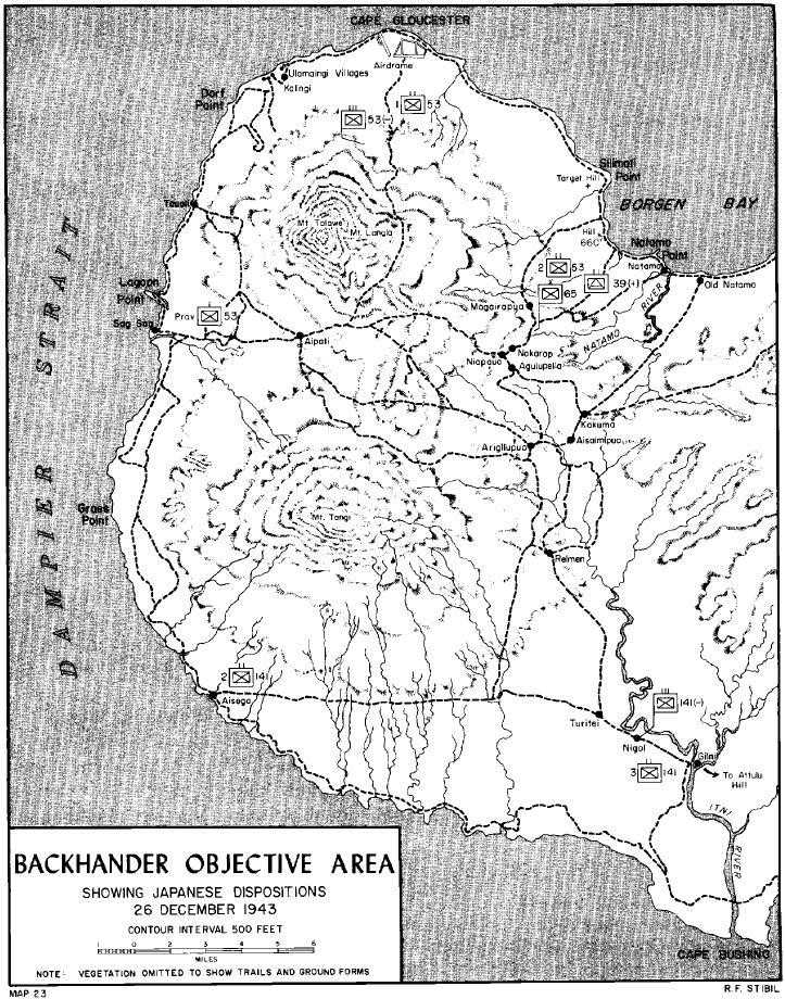
was down to a strength of one two-battalion infantry regiment and supporting signal, engineer, and medical troops when it reached New Britain. Only the 141st Infantry came from the Philippines; the 142nd Infantry, once part of the brigade, remained there, and the 122nd Infantry was sent to the Marshalls. In addition to regimental headquarters and signal companies, the 141st had an antitank company equipped with six 37-mm guns and an artillery company armed with four 75-mm mountain guns. Each infantry battalion of the regiment had a headquarters and supply train, three rifle companies, a heavy machine gun company, and a gun platoon manning two 70-mm howitzers. (See Map 23.)
Throughout the summer, the 65th Brigade’s main concern was keeping the supply lines to New Guinea open. Most of the units attached to it were companies or smaller elements of service organizations concerned with the barge traffic, airfield construction and operation, or the logistical support of the garrison. One type of unit, however, antiaircraft troops, added significantly to defensive firepower, both against Allied aircraft and ground forces. Each of the 39th Field Antiaircraft Battalion’s three firing batteries had four 75-mm guns that could be used against ground targets. The 28th and 30th Machine Cannon Companies both had eight dual-purpose 20-mm guns and six heavy machine guns.
The Eighth Area Army’s interest in the defense of western New Britain picked up considerably as the situation in the Salamaua area worsened. On 5 September, a new command, the Matsuda Force which took its name from its commander, Major General Iwao Matsuda, took over the 65th Brigade, the various shipping engineer and debarkation units, and a number of troops of the 51st Division.7 The main body of the 51st was fighting the Australians on New Guinea, but the division’s rear echelon units as well as the survivors of transport sinkings were present on New Britain, Garove, and Rooke Islands. Of particular value to Matsuda’s force as combat troops were two companies of the 115th Infantry and a smaller detachment of the 66th Infantry, two provisional infantry companies formed from artillery and engineer elements of the division, and about half of the 51st Reconnaissance Regiment.8
General Matsuda was an infantry officer with considerable experience in the Army’s shipping transportation department. He had commanded an infantry regiment in China and an infantry group in Manchuria before taking over the 4th Shipping Command in February 1943. The command, an administrative headquarters geared to handle shipping activities, moved from Japan to Rabaul by way of eastern New Guinea, arriving in New Britain in early August. On 29 October, when Matsuda was also appointed to command the 65th Brigade, he formed a composite headquarters for the Matsuda Force by merging the staffs and headquarters of the brigade and the shipping command.9
About a month after Matsuda established his command post near Kalingi mission at Cape Gloucester, his force came
under the 17th Division. The division, newly arrived in Rabaul from China, was commanded by Lieutenant General Yasushi Sakai. Originally, the 17th had been slated to reinforce the garrison of northern Bougainville, but General Imamura changed its mission when he was assured by the Southeast Area Fleet that it could keep another large body of men supplied in western New Britain. On 5 October, the Eighth Area Army commander added the Matsuda Force and the Gasmata garrison to General Sakai’s command and ordered him to assume responsibility for defense of New Britain west of a line joining Commodore Bay and Vahsel Harbor. Division headquarters was established at Malalia near Cape Hoskins to the east of Williaumez Peninsula.
The first echelon of the 17th Division left Shanghai on 24 September, arriving at Rabaul on 4-5 October. Three more convoy groups were to bring the remainder of the division, but shipping losses and the mounting danger of attack by Allied planes and submarines combined to cancel the sailing of the last convoy, which was to have lifted a number of service troops and 3,000 infantry replacements. The second and third convoys which departed from Shanghai late in October lost one ship to submarines while passing through the Ryukyu Islands, had another damaged by B-24s south of Truk, and lost a third to a mine off Kavieng. Total casualties from the three attacks were 1,173 men killed and wounded.10
The main strength of the 17th Division’s 53rd Infantry Regiment and the regimental headquarters and 3rd Battalion, 23rd Field Artillery were assigned to General Matsuda’s command to reinforce the defenses in the immediate vicinity of Cape Gloucester. Also coming under Matsuda Force was the 1st Battalion, 81st Infantry which was ordered to Cape Merkus. The 3rd Battalion, 53rd Infantry and the 6th Company of the 2nd Battalion were detached from the regiment to serve on Bougainville as was the rest of the 81st Infantry, a battalion of the 54th Infantry, and one of the 23rd Field Artillery. The remaining units of the 54th and 23rd were distributed between Gasmata, Malalia, and Talasea.
With a battalion and a rifle company stripped from its strength, the 53rd Infantry was little stronger than the 141st. Regimental headquarters and supporting companies in both units were the same, with the 53rd having in addition a platoon of 90-mm mortars. The 1st Battalion of the 53rd had four rifle companies, but the commitment of the 6th Company on Bougainville pared the 2nd Battalion to three. Eighth Area Army kept control of two rifle companies, the 70-mm howitzers, and most of the heavy machine guns of the 1st Battalion, 81st Infantry, leaving the reinforcements for Cape Merkus at a strength of a headquarters and two rifle companies plus a machine gun platoon.
Japanese destroyers were used to transport the 17th Division troops to western New Britain with most units landing at Karai-ai and carrying on by barge or trail to Cape Gloucester. The waters along the south coast were too close to Allied bases to risk destroyers there, so the skeleton battalion headed for the Arawe area had to march overland to its post. Since the 1st Battalion, 81st Infantry had been on board the transport torpedoed during the move from China, it had to be reorganized
and refitted in Rabaul. It was early December before the battalion landed at Iboki, terminus of a cross-island trail to Cape Merkus.
While the last of the 17th Division reinforcements were moving into position in western New Britain, General Matsuda took steps to increase his combat strength by organizing a third battalion for the 141st Infantry. The existing two battalions of the regiment furnished the men for the headquarters, one rifle company, and most of the machine gun company; the men of the 66th and 115th Infantry detachments formed the remaining two rifle companies and a platoon of machine guns. The new unit began organizing on 12 December and was formally joined to the regiment on the 20th.
The deployment of Matsuda’s forces, as the time of the expected Allied assault approached, reflected the importance the Japanese general attached to the various objectives in his defensive area. Holding the vital airfield sector was the 1st Battalion, 53rd Infantry, reinforced by the regiment’s 37-mm and 75-mm guns and a miscellany of service troops. Beach defenses, mainly bunkers connected by rifle trenches, were scattered along the shore on either side of Cape Gloucester. The heaviest concentration was located back of the most logical site for a large-scale landing attempt, a stretch of beach three miles southeast of the cape that led directly into the grasslands. In the foothills of Mt. Talawe, hidden by the lush vegetation, was a bunker-trench complex that commanded the airstrips.
Knowing what lay behind the beaches near Silimati Point, the Japanese paid scant attention to their defense. Just to the south, however, a strong force built around elements of the 1st Shipping Engineers and the 39th Field Antiaircraft Battalion held the sector where the trail net from the interior reached the coast. Matsuda’s scheme of defense depended upon retaining possession of the trails to move his limited manpower to meet Allied attacks. Two small hills which dominate the area served as focal points for enemy defenses. One, a 450-foot height called Target Hill by the Allies, stands out starkly above the swamp forest, its open, grass-covered crown in sharp contrast to the surrounding sea of trees. A mile and a half south of Target Hill, Hill 660 rises out of the jungle with a cover of tangled growth that blends easily with its environs.
Across the island, in the vicinity of Cape Bushing, was the defensive sector assigned to the 141st Infantry. The 1st Battalion was located near the mouth of the Itni, the 2nd occupied defenses at Aisega, and the newly formed 3rd was in reserve at the regimental headquarters at Nigol, a village on the Itni about three miles above Gilnit. Farther down the coast at Cape Merkus the defending force was composed of a platoon of naval personnel manning a communication relay station11 and two provisional infantry companies formed from elements of the 51st Division.
The garrisons of Rooke and Garove Islands were also part of the Matsuda Force. On Garove, the principal unit was the 5th Sea Transport Battalion with an antiaircraft battery and shipping service units attached. The headquarters and two companies of the 51st Reconnaissance Regiment were still on Rooke on D-Day, but, prior to 26 December, a reinforcing 75-mm gun battery and about half of the regiment’s
cavalrymen were sent to New Britain to bolster the 141st Infantry’s defenses.
In November, General Matsuda moved his headquarters from Kalingi to a concealed position in the rain forest near Nakarop, a village on the main cross-island trail about seven miles inland from Borgen Bay and a thousand feet above sea level on Talawe’s lower slopes. Close by the new Matsuda Force command post, the general stationed the 2nd Battalion, 53rd Infantry as general reserve, ready to move by the mountain trails to the airfields, to Cape Bushing, or to Target Hill as the situation demanded.
By mid-December, the effective strength of Matsuda’s command, including all classes of troops in the area west of an Iboki-Arawe boundary, stood close to 10,500 men. The figure represents 9,500 that Matsuda reported to General Sakai on 1 December, plus an estimate of the combined strength of the 17th Division units— 1st Battalion, 81st Infantry; 3rd Battalion, 23rd Field Artillery; 2nd Field Hospital—that reported from Rabaul later in the month. Roughly half of the total force was located in positions within effective supporting range of Cape Gloucester.
The enemy leaders were well aware that the Allies had the strength to take western New Britain, but the Japanese were determined to make a bloody fight for its possession. On 12 December, in a message addressed to all the officers in his command, General Sakai warned that a landing was imminent and that in meeting the Allied assault force each man was to observe the principle of “certain death warfare to the utmost, in such a way that not even the slightest disgrace will adhere to your name.”12
Knowledge of the Enemy13
Aerial reconnaissance kept the Japanese informed of concentrations of Allied landing craft off the coast of New Guinea, but the traffic was so heavy that no clear picture emerged as to when a move was coming against western New Britain. False alarms were frequent as the end of 1943 approached, but all the reports of pilots of the Eleventh Air Fleet at Rabaul and the Fourth Air Army at Wewak could do was confirm the estimate that a large-scale landing was in the offing. Even more unsettling to the Japanese commanders was the knowledge that Allied scouting parties had landed repeatedly in the territory defended by the Matsuda Force and departed with valuable intelligence.
General Krueger, confronted by a serious lack of information about the terrain, beach conditions, and defenses of possible ALAMO Force objectives, had formed a group of scouts whose job it was to land behind enemy lines and find the answers to vital questions that plagued intelligence officers. The ALAMO Scouts, who operated directly under Krueger, were a composite force of Australians with
experience in the islands, American intelligence personnel, and natives of proven loyalty and dependability. In preparing for BACKHANDER operations, a number of the 1st Marine Division’s own scouts, led by First Lieutenant John D. Bradbeer, took part in pre-D-Day reconnaissance on New Britain with men from the ALAMO Scouts.
Usually, the scouting parties travelled to their objective by torpedo boat, landed in rubber boats, and moved inland to establish a patrol base well off the regular tracks. Fanning out from this point, the scouts contacted the local populace and tried to observe enemy dispositions. When the mission was accomplished, or, as often happened, the Japanese got wind of the presence of the scouts and started to hunt them down, the torpedo boats returned and took off the party. Occasionally, the reconnaissance was an assignment to spot-check preferred beaches and their defenses, a mission in which success depended upon the scouts’ ability to obtain essential information quickly and accurately.
Three Australian officers were particularly concerned with the scouting in western New Britain—Major John V. Mather, AIF, who had served with the 1st Marine Division on Guadalcanal and had been a labor contractor in the Solomons, Sub-Lieutenant Andrew Kirkwell-Smith, RANVR, who had been a coastwatcher at Cape Gloucester before the Japanese came, and Sub-Lieutenant William G. Wiedeman, RANVR, who had been the Anglican missionary at Sag-Sag. The local knowledge of these men was invaluable to division intelligence, as was their understanding of the natives and their ability to teach others how to live and operate successfully in the jungles of New Britain.
The first party with American scouts to go ashore in the objective area was led by Bradbeer and Kirkwell-Smith. After it landed near Gross Point on 24 September, the nine-man patrol operated two weeks in the region south of Mt. Tangi looking for a trail that was supposed to wind south around the mountain and go over the saddle between Tangi and Talawe. Although the search was unsuccessful, the party brought back much useful information, particularly the welcome news that the natives were at odds with the Japanese. In July, the enemy had cleared all the inhabitants from the coastal villages and those near the airfields, forcing an exodus to the interior. Since that time, the natives had noticed that many of the Japanese were sickly and on short rations, so much so that the soldiers had begun to raid the village gardens for food. The scouts retraced their steps to the coast and left the island on 6 October after they received word that enemy patrols were looking for them.
In mid-October, a small Australian-led party, most of its personnel borrowed from the coastwatcher organization, landed on Rooke Island. In two weeks ashore, the scouts found little evidence of a large enemy garrison and pulled out undetected. A month later, a planned 24-hour patrol, led by First Lieutenant Robert B. Firm of the 5th Marines R-2 Section, went ashore below Dorf Point to check possible landing beaches in the vicinity. The enemy was too active to make any move inland feasible, but Firm was able to determine that the beach was not usable before he had to order his men back into the rubber boats.
Since Admiral Carpender did not want to risk torpedo boats north of Cape Gloucester, it proved impossible to make
a reconnaissance of the main beaches near Silimati Point. An ALAMO Scout party did land at Arawe, however, on the night of 8-9 December and concluded that few Japanese were present to hinder the projected assault there. On the night of 21-22 December, Bradbeer and First Lieutenant Joseph A. Fournier of 2/1 led two parties ashore to check the beaches near Tauali. The Marine scouts confirmed the selection of GREEN Beach as the best that could be found for the landing; no enemy forces were encountered. Coming away from New Britain the torpedo boat transporting the scouts attacked some Japanese barges; in the exchange of fire, three American crewmen were wounded and an engine was knocked out, but the boat got back to base safely.14
The ALAMO Scouts were not the only group to penetrate the Japanese defenses on New Britain. As usual, the coastwatchers were there, a constant irritant to the enemy. One station set up inland from Cape Orford was in operation through the summer, giving warning of flights from Rabaul and passing on information of the Japanese forces. On 30 August, General Kenney requested that a series of air spotting stations be established across the base of Gazelle Peninsula. General MacArthur agreed and his G-2 ordered the coastwatcher directorate, Allied Intelligence Bureau, to have the spotters in position by November. Sixteen coastwatchers and 27 natives landed from a U.S. submarine on 28 September and separated into five parties to take their posts in the rain forest cover on the island’s mountainous spine.
The Japanese managed to capture one of the parties, but the others kept free of searching patrols, sending their reports of enemy flights directly to fighter controls at Woodlark and Dobodura that alerted interceptors at Nadzab’s fighter strips. The location of the chain of observers promised 30 to 60 minutes’ advance warning of Japanese attacks on Cape Gloucester, time enough for Allied fighters to rendezvous at the most favorable altitude and meet the raiders.
The reports of scouts and coastwatchers were only a portion of the intelligence sifted to get accurate information about New Britain and its defenders. Japanese documents and prisoners taken on New Guinea and Bougainville proved a fruitful source of order of battle data, and at MacArthur’s, Krueger’s, and Rupertus’ levels of command there was a constant re-evaluation of the strength of the defending force in western New Britain. In light of the difficulty of piecing together the various scattered segments of news, the picture of its opponents that the 1st Marine Division was able to assemble was a remarkably good one.
When the BACKHANDER Force operation plan was issued on 14 November, the intelligence estimate of enemy strength west of Arawe on New Britain and on Rooke and Garove was 7,071 men. The total moved steadily upward as elements of the 17th Division were identified as part of the garrison. On 9 December, the various Allied headquarters published minimum-maximum enemy strength figures for western New Britain that differed considerably. While MacArthur’s and Blamey’s intelligence officers were content to count only the sure identifications, there was little disposition at Krueger’s or Rupertus’ command posts to ignore signs, however slight, of Japanese units that might dilute the superiority of attackers
over the defenders. Where GHQ and Allied Land Forces found a strength range of 4,000-5,000, ALAMO Force had 5,668-9,344, and the 1st Marine Division figured 7,416-9,816 enemy were present.15 The final division estimate before the Arawe landing placed the lowest strength at 8,400 and the highest at 12,076.16 Although the division’s educated guess proved to be high, the figures were reasonable in view of the information available.
A scattering of evidence indicated that the 65th might have been raised from brigade to division status, providing a basis for a belief that at least one other of its regiments besides the 141st Infantry was present. Accordingly, the 142nd Infantry, which could not be accounted for elsewhere, was added to the order of battle. Similarly, additional companies of units known to be at Cape Gloucester in some strength were counted present if they failed to turn up in other sectors. In the absence of more exact figures, Japanese tables of organization were used as the basis for strength estimates, with 20 percent deducted for losses of all types. Acting to counterbalance the inflated totals was the fact that the presence of the remnants of the 51st Division, including the 51st Reconnaissance Regiment, went undetected.
The location of the various elements of the Matsuda Force remained a worrisome problem to Allied intelligence officers. The 17th Division reinforcements arrived so close to D-Day that their defensive assignments were unknown, and it was not clear just what combat units occupied the located defenses. Confusing the situation further was the fact that Japanese place names on western New Britain were a far cry from the names found on prewar Australian maps.
While the enemy accepted and used most of the native place names in western New Britain, the result of such use was often an unrecognizable title. Allied POW interrogators and the translators of Japanese documents had to judge how native speech had been rendered in Japanese and then, in turning the result into English, to try to come close to the original. And often this transition involved the additional problem of considering how differently native dialects would be set down by persons used to Australian and American speech. Intelligence officers, at least, became well acquainted with the Japanese name for Cape Gloucester, translated interchangeably as Tuluvu or Tsurubu. Other names could not be identified. The headquarters of General Matsuda appeared as Egaroppu when translated, a fact that prevented its recognition as Nakarop on prewar maps.17 And there were puzzling references to villages that could not be plotted anywhere along known trails.
On the whole, however, the maps available to BACKHANDER Force were useful, if not precisely accurate. A German survey of the island, made prior to the first World War, was the base on which later maps were constructed. On these, the trails along the coast were plotted with some care, but the location of trails crossing the interior were at best approximations. As western New Britain attracted Allied attention as a possible objective, repeated aerial photographic missions were flown over it in an effort to improve knowledge
of its terrain. When MacArthur’s cartographers were ready to draft operation maps in October 1943, the aerial photographs gave them a clear picture of coastline and offshore reefs, terrain in the few open areas, and prominent heights, but the jungle trees gave up little of the secrets that lay beneath their branches. Information needed to plot inland trails, villages, and streams was often taken from old maps and charts and from the memories of islanders who had visited or lived on New Britain.
The map most often used by planners and combat troops was drawn in a scale of 1:20,000 with a thousand-yard military grid superimposed. On the back of each of the seven sheets it took to cover the coast from Borgen Bay to Cape Bach and the interior to include Mt. Talawe was the photo mosaic used in making that segment. Two other maps frequently used by higher headquarters were also printed in quantity; one covered the immediate objective area in a one-mile scale and the other showed all of New Britain at an inch to every four miles. To help troop leaders visualize the terrain where they would be fighting, the 1st Division’s relief mapping section modeled the ground forms of the YELLOW Beach, GREEN Beach, and airfield areas in several small scales. Copies of these relief maps were then moulded and distributed to division units and other elements of the landing force.
While Marine intelligence officers worked hard to assemble information on the enemy and the objective in order to brief assault troops, they devoted as much attention to the problem of procuring information after the landing. Deliberate and repeated stress was given in all division training to the need for passing along promptly any enemy papers or material that were found. Emphasis was laid, through demonstrations and review of combat experience, on the fact that the most insignificant appearing document might provide the key that would shorten the battle and save lives. The Marines were reminded of the importance of taking prisoners and of the ordinary Japanese soldier’s willingness to cooperate with his captors in providing military information once he had surrendered.
To process the flow of intelligence on D-Day and after, the intelligence sections of combat teams and division were set up to give a quick evaluation to captured enemy maps, diaries, and orders. Information of immediate use to Marine commanders was to be extracted and the documents passed on to the ALAMO Force headquarters for definitive translation. In the same manner, prisoners were to be interrogated as soon as possible after capture to extract what intelligence they had of use to BACKHANDER Force, and then shipped out for further questioning in New Guinea. To help speed the search for useful information in enemy documents, ten Nisei were borrowed from Sixth Army to augment the division’s own language section.
One other source of up-to-date information of the enemy was available before D-Day—the DIRECTOR operation. If the Arawe assault had its hoped-for diversionary effect, Japanese troops would be drawn off from the area of the main landings. Any contact General Cunningham’s cavalrymen had with elements of the Matsuda Force promised intelligence of value to the Marines who were headed for Cape Gloucester. Exact answers to questions about the enemy’s ability and will to fight and his dispositions to meet Allied attack could only be found ashore on New Britain.