Chapter 3: Effects of Aerial Photography on Mapping and Camouflage
To exploit fully the advantages of speed and mobility made possible by the motor vehicle, the tank, and the airplane, the new Army had to have maps charting areas deep within enemy territory. The Corps of Engineers, guided by the plans and policies of G-2 of the War Department General Staff, worked out the technical details and troop organization to meet demands for large quantities and different types of military maps. Essential to the accomplishment of this task were the motor vehicle and the airplane, but most of all the airplane and its potential product, aerial photography.
Topographic maps, which present both horizontal and vertical positions of terrain, are needed for most military operations. For making plans involving a large combat area, command and staff headquarters require general maps of a scale smaller than 1:1,000,000 and strategic maps of somewhat larger scale that show the relief, the major systems of communication, bodies of water, and centers of population. Air force navigators use charts of similar scale for long-distance flights. The stabilized trench warfare of World War I accustomed American artillery units to the highly accurate large scale—1:20,000—battle map for firing on unobservable targets, and the Field Artillery clung to this map despite the distinctively mobile characteristics of the new Army. Even in a war of movement, the Field Artillery insisted, it must have such large-scale battle maps in order to reduce enemy strongholds and thus open the path for the advance of infantry and armor. Between the extremes of the strategic map and the precise battle map are tactical maps of scale 1:100,000 and larger which are of primary interest to field commanders for selecting routes, controlling troop movements, and locating the enemy. Exact representation of transportation systems down to the measurement of roads is shown on the tactical map. If tactical and battle maps are not available, troops can secure terrain information from the more quickly prepared map substitutes. The photomap, for example, is an aerial photograph to which are usually added grid lines, contours, and place names, as well as indications of scale and direction. Although more difficult to interpret, map substitutes yield much more information than the hasty field sketches relied upon before advent of the airplane.
Mapping Techniques
Before development of the airplane and aerial photography, maps were prepared from data gathered by survey parties. Even with highly refined instruments for measuring distances and angles, such field surveys
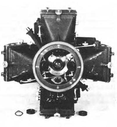
Five-lens camera, T-3A
are time-consuming and costly. In rough terrain, forests, and swamps this work is especially difficult; in enemy territory it is virtually impossible because field parties have to occupy the ground they survey.
Freedom from dependence upon ground surveys was forecast during World War I, when Maj. James W. Bagley, a former civilian employee of the U.S. Geological Survey and a pioneer in American photomapping, brought his recently invented trilens camera to France. Bagley’s camera took one vertical and two oblique photographs and in that way produced a much larger picture than the single lens camera previously used. Study of these photographs enabled topographic engineers to overprint the sites of enemy trenches and gun emplacements on existing base maps. These experiments had more bearing on later developments than on the immediate mapping effort because there seemed little chance of improving the existing coverage of the Western Front with photomapping equipment and techniques then available. But the Chief Engineer, AEF, recognized the potential value of aerial mapping and collected much material for the guidance of future research.
Soon after the Armistice, Bagley was placed in charge of a small Engineer detachment at Wright (then McCook) Field to work with the Air Service in applying aerial photography to military mapping. Although the Wright Field detachment seldom exceeded two officers, six enlisted men, and a few civilians, it gradually provided a nucleus of expert photogrammetrists. In the course of his experiments, Bagley developed a five-lens camera, the T-3A, which became the standard mapping camera of the thirties. The aerial photographs taken by this camera, or any other for that matter, convey only a relative idea of relief and of distances. With preliminary knowledge of distances between several points on the photograph, topographers could compute the remaining measurements so as to prepare a two-dimensional or planimetric map, but field surveys were still necessary to determine every elevation or contour line that would show up on a three-dimensional topographic map. To eliminate the production bottleneck entailed by survey operations, map makers required instruments for determining elevations directly from the photograph.1
In 1936 1st Lt. Benjamin B. Talley of the Engineer detachment at Wright designed a simple stereoscopic plotting instrument for this purpose. By viewing overlapping aerial photographs through a stereoscope, topographers could obtain an impression of the
terrain in relief from which they could sketch the lay of the land. Talley combined the stereoscope with measuring and drawing attachments. With this device and the aid of special mathematical tables, a topographer could determine vertical distances fairly accurately. The new instrument, the stereocomparagraph, was small and portable and could be carried into the field to make maps good enough for reconnaissance. It was not sufficiently refined for preparing the battle maps desired by the Field Artillery, however, unless a large number of points of elevation were known.2
More refined stereoscopic instruments had been developed abroad. By 1936 the Engineer detachment had studied a number of these instruments and had narrowed its choice to the aerocartograph and the multiplex aeroprojector, both of which were made in Germany by Zeiss. The aerocartograph was slightly more accurate, but it was also more expensive, more difficult to operate, and almost impossible to move about. The detachment chose the multiplex set, but even this weighed about 1,800 pounds and required shelter for operation. The multiplex set consisted of a number of delicate instruments for measuring the spatial projection of images of the landscape. During 1936 and 1937 the Field Artillery tested topographic maps which the Engineer detachment prepared with the multiplex set. Although these maps depicted areas extending from 12 to 20 miles into unsurveyed territory, they were almost as accurate as the Field Artillery desired. To eliminate reliance on foreign sources, the Engineer Board persuaded the Bausch and Lomb Optical Company, an American manufacturer of microscopes, lenses, and scientific instruments, to add the multiplex to its list of products. Working closely with the Engineer detachment, Bausch and Lomb improved the design, lenses, and lighting of the German model so as to produce sharper images of the landscape. By February 1939 the first American multiplex had appeared. Multiplex sets were subsequently assigned to two of the three engineer mapping units, the army topographic battalion and the base topographic battalion.3
Production of the battle map was the army topographic battalion’s main task. Tactical maps would be compiled as time allowed because at the outset of any conflict in a theater where map coverage was scanty, it would be impossible for topographic units to prepare both. Reproduction of existing maps was a major task for all topographic echelons. The army battalion could reproduce large quantities of maps in dimensions up to 22x28 inches, but in case it could not meet demands within its area, it could call upon the base battalion for assistance. Further potential sources of map supply were the Engineer Reproduction Plant at Washington, which was staffed by civilians under military administration and which had fairly elaborate lithographic equipment, and a number of federal agencies, such as the U.S. Geological Survey, which compiled original maps for various purposes, using modern photogrammetric
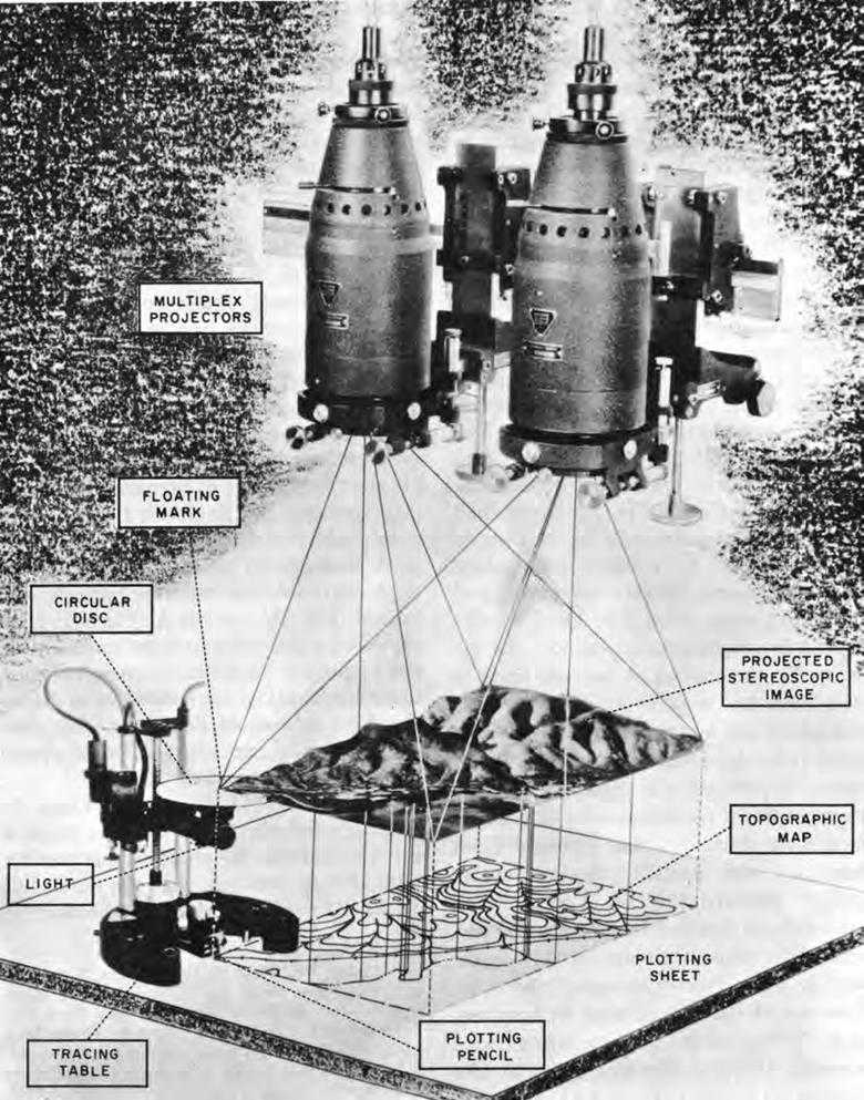
Multiplex Set
techniques. Lower echelons in the army would ordinarily be served by the corps topographic company, which had been formed when the shift from the square to the triangular division eliminated mapping from that organization. Like its predecessor, the mapping section of the engineer combat regiment, but on a much broader scale, the corps company had the job of reproducing existing maps and of preparing photomaps and other types of map substitutes.4
Substitution of photomapping for time-consuming ground surveys offered great advantages to all topographic units, but this change-over had its disadvantages also. The new mapping techniques placed the Corps of Engineers in a position of dependence upon the Air Corps. The Air Corps had photographic requirements of its own in preparing charts for strategic and tactical planning, for long distance navigation, and for plotting target areas. The Air Corps also had to fly reconnaissance missions for the Army. To the conflict of interests likely to arise from this multiplicity of tasks, there was added the fact that mapping photography called for a higher degree of skill and more complex aircraft than did charting photography or reconnaissance. “I doubt if there is any flying ... that is more difficult than ... high altitude mapping photography,” declared Captain Talley. “It is more difficult than bombing because 95 percent of the time on a bombing mission the pilot is flying ‘across country,’ the other 5 percent of the time he must fly very precisely.”5 For mapping, these figures were reversed. Mapping required flights at altitudes of 20,000 feet. The Air Corps had to crowd in as many flights as possible whenever weather permitted. Unless the pilot flew in parallel straight lines close enough for the photographic strips to overlap, there were either too many or too few prints. An excessive number of prints slowed down compilation, but too few left gaps in the map and necessitated reflight. The pilot had to maintain a uniform altitude and avoid tip and tilt of the plane to keep the photography in proper perspective.
The relative crudeness in aircraft design and navigational equipment made these operations strenuous even in peacetime. At high altitudes photographic crews sometimes fainted from lack of oxygen or suffered frostbite from cold. It was therefore tempting to gloss over this work, losing sight of specifications, and consequently multiplying the complexities of preparing the final map. In 1937 the Engineers began to express doubt that the Air Corps could do the work satisfactorily unless aircraft assigned to photographic missions were radically improved. The Chief of the Air Corps in turn expressed a desire for an exact statement of the Engineers’ photographic requirements. Once specifications were set down in detail, the Air Corps could determine what personnel, planes, cameras, and other equipment had to be provided.6
From Wright Field, Capt. Louis J. Rumaggi suggested that in many respects the specifications for photographic and for high altitude bombers were the same. But 1st Lt. Richard R. Arnold who headed the
mapping section at the Engineer Board questioned the feasibility of obtaining suitable wartime photographic coverage with bombers. Not only were bombers unwieldy and exposed to enemy attack, but they would certainly be confined to their primary task. “In time of war, bombers will be required for Air Corps bombing missions and will not be available for photography when they are needed. The largest number of photographic mapping missions will probably be required immediately following the outbreak of hostilities. It is during this time also that there will be the greatest number of bombing missions to destroy enemy factories and depots. Mapping missions will undoubtedly suffer.”7 In the report which he prepared for the Engineer Board in response to the inquiry from the Chief of the Air Corps, Arnold set forth the following characteristics as essential for planes assigned to mapping photography:
a. A minimum service ceiling of 30,000 feet or more
b. A size suitable and economical for its mission
c. A maximum of visibility
d. Six hours endurance
e. A cruising speed of 200 m.p.h.
f. A gyro-pilot and provision for heating and supercharging the cabin
g. Mounting for two T-3A [five-lens] cameras in tandem.8
Arnold took this opportunity to emphasize the advisability of close cooperation between the Corps of Engineers and the Air Corps, urging the Air Corps to activate a photographic mapping squadron to work with the base engineer topographic battalion and to appoint a liaison officer to the Engineer Board. The officer, Maj. Charles Y. Banfill, arrived soon after Arnold’s report was forwarded to the Air Corps in March 1938. The following September, Kingman reopened the subject of the special plane and the Air Corps indicated that lack of funds was preventing its development. In January 1939 this obstacle was seemingly removed when the Air Corps received authority to include in its budget a sum for this purpose. These signs of activity on the part of the Air Corps were encouraging to the Engineers.9
The Air Force-Engineer Team
The Field Artillery, having followed Air Corps-Engineer experiments with a special interest because its requirements for accuracy in maps exceeded those of the other arms, concluded that the application of aerial photography to mapping was sound. It was clear, the Chief of the Field Artillery informed the Chief of Engineers in November 1937, that the basic problems had been solved. Certain “refinements”—improvements in quality and quantity—still had to be achieved, but these were of less immediate concern to him than the clarification of responsibilities between the Corps of Engineers and the Air Corps. Although the Engineers were inclined to think that their relationship to the Air Corps was sufficiently clear and that cooperative efforts with that arm were producing good results, Kingman,
at the Field Artillery’s insistence, forwarded copies of the file to G-2 in March 1938.10
The correspondence came to Lt. Col. Orlando Ward, himself an artillery officer, for handling. On 6 July, after getting the comment of various interested parties, Ward laid his conclusions before the Chief of Staff. He called attention to the inadequacy of existing coverage of the United States and to the noteworthy progress in the field of photomapping, and then advanced a new and radical principle. In the event of war, he declared, “the Army should be prepared to map as it moves.” Following a military mapping service test to be held in the summer of 1939, Army regulations and field manuals would be revised along these lines, giving aerial photography the prominence it had earned and defining the respective duties of Air Corps and Engineers in peace and war.11
The camera used in this test was the five-lens model T-3A which had been developed by Bagley at Wright Field. When two T-3A’s were placed side by side they produced a composite photograph that covered an area of about 400 square miles. With this camera, the Air Corps’ 91st Observation Squadron photographed an area of 5,800 square miles in southern California between 10 March and 15 May 1939. This preliminary operation lasted over two months because the weather was often unfavorable. In the scheme of production, the 29th Engineer Topographic Battalion (Army) first prepared planimetric sheets which were issued as provisional maps. Then multiplex operators determined elevations and filled in contours by stereocomparagraph. For an extension of 42 miles beyond surveyed territory, the average errors amounted to 34 feet in elevation and 81 yards in horizontal position. Although these maps were less accurate than those prepared on previous tests, they covered much greater distances. Furthermore, once photography was in hand, the rate of production was high. Starting on the fifteenth day after delivery of photographs, the battalion prepared 1 OO square miles of contour maps a day.12
On the whole the results of the military mapping test were deemed favorable. Basing his conclusion on reports from lower echelons, Maj. Gen. Albert J. Bowley, a former artillery officer commanding the Ninth Corps Area, commented that the mapping at this test was acceptable both as to speed and quality and recommended adoption of the methods and equipment used by the 29th Engineers. In this connection, Maj. Russel McK. Herrington of the 29th Engineers stated that the method of map compilation from multi-lens photography was faster than any other so far discovered, and Col. W. Goff Caples, Engineer, Ninth Corps Area, remarked that “accuracy, while desirable always, is entirely secondary to speed in the choice of equipment and methods for making the Battle Map.”13
While equally enthusiastic about the possibilities of photomapping, a number of individuals saw room for improvement, particularly in equipment. From the west coast, Air Corps and Engineer officers telegraphed
to the War Department the urgent necessity for better aircraft. Kingman, commenting on this demand, expressed understanding of the many problems facing the Air Corps and a willingness to accept the Air Corps’ assurance that the simple, inexpensive plane currently furnished, the Beechcraft F-2, was merely a step in the right direction, not the last word in design. Kingman nevertheless took the opportunity to list once more the special features that an airplane destined for photographic work should have. In further comment to G-2 the Engineers stressed the inherent differences between mapping photography and that which the Air Corps was required to make for intelligence purposes. In order to obtain pictures of extensive areas rapidly and at a scale consistent with accurate delineation of terrain, mapping photography had to be accomplished at high altitudes with cameras of wide coverage. Intelligence photographs, by contrast, had to be obtained at relatively low altitudes in order to acquire detailed information about the enemy’s position and installations. Such photographs could be secured by semiskilled personnel operating from simple observation planes. Mapping photography demanded not only special planes but also special air force units to perform this work to the exclusion of all other duties.14
Despite the generally favorable reaction of the Field Artillery, Capt. Frederick J. Dau, in command of the Engineer detachment, expressed doubt that the multi-lens photography employed in the test permitted compilation of sufficiently accurate maps. The T-3A camera had originally been designed for making planimetric maps, and, owing to the presence of obliques which surrounded the small center photographs, was not altogether adaptable to multiplex work. Oblique multiplex projectors produced errors of ten times the amount specified for projectors used in connection with vertical photography. Not only was much of the composite unfit for multiplex mapping, but the loss of detail away from the center also reduced its value as a photomap. Dau recommended replacing the T-3A camera with a new single-lens wide-angle camera which the Air Corps and the Corps of Engineers were jointly developing. Like many other valuable mapping instruments, the camera with wide-angle lens had been introduced in Germany by the Zeiss firm. In 1936, upon the recommendation of a German scientist employed by the Engineer detachment, the Air Corps had purchased a Zeiss wide-angle camera. Two years later the Air Corps began to procure wide-angle lenses from Bausch and Lomb and awarded a contract for the camera bodies to the Fairchild Aviation Corporation. This camera, known as the T-5, was designed to register tilt variations, altitude, and other data on the film to facilitate compilation of the map. The Engineer detachment concurrently adapted the multiplex for use with wide-angle photography. Bausch and Lomb again cooperated in this effort, and in December 1938 the Corps of Engineers ordered fifteen experimental wide-angle projectors from the firm.15
The T-5 camera took standard 9½-inch film which could be printed more rapidly than the several 6-inch films that made up the multi-lens composite. Its photograph covered an area more than twice as large as the vertical part of the composite and thus eliminated the excessively complicated rectifications that accompanied use of oblique photographs. A wide-angle photograph could serve directly as a map substitute. All this would save time for engineer topographers and increase accuracy. The T-5 camera also seemed preferable to the Air Corps because it was lighter and more compact than the T-3A and would thus be easier to install in an airplane. But the T-5, if employed singly to take vertical pictures as the Corps of Engineers desired, would make the Air Corps’ task more difficult. With the T-3A camera mounted in tandem, flyers could space their courses about eight miles apart. With the T-5 camera they had to make twice as many runs. Furthermore, as Major Herrington pointed out, the T-3A had a great advantage over the wide-angle equipment, namely, it was already in production, whereas development of the T-5 had progressed only to an imperfect pilot model. When advantages were weighed against disadvantages, however, the T-5 camera seemed vastly superior. In March 1940, at a conference called by the Corps of Engineers, representatives of the General Staff, Air Corps, and Field Artillery agreed to retain the older type of mapping equipment only as a stopgap until the wide-angle camera and plotting accessories became generally available.16
By this time revision of the Army regulation and field manual was well on its way toward completion. Ward, now secretary of the General Staff, continued to display keen interest in the project, although its details had been turned over to Capt. Howard V. Canan, an Engineer officer who had taken Ward’s place in G-2. Before Canan were the glowing reports of the military mapping test. Unchallenged was Ward’s “map as you move” dictum. Unquestioned was the view that battle maps were the most universally desirable means of presenting terrain information. Unmentioned was the interference to be expected from hostile aircraft. All that was lacking, it seemed, were special photographic planes manned by expert crews. To Canan’s dismay, G-3, which was at this time headed by an Air Corps officer, soon made clear its intention of permitting this lack indefinitely, if not permanently. To attain speed in the production of aircraft, G-3 insisted, the number of types of planes must be held to a minimum. Mapping photography was a natural adjunct of Army reconnaissance, G-3 maintained. Reconnaissance crews, taking intelligence photographs at low altitudes in normal weather, would be on hand for mapping photography on the few days when clouds were not present at high altitudes. Photographic missions were no more difficult than bombing missions. Reconnaissance units could be taught to produce the high quality of photography desired.17
Canan revised his drafts only slightly to conform to G-3’s wishes. The need for the manual and for consolidating gains thus far obtained dictated an early publication even though it was far from perfect. If experience demonstrated, as Canan believed it would, that the Army’s requirements could not be filled as easily as G-3 supposed, the subject of special equipment and crews could then be reopened. As finally published in May 1940 the Army regulation and the field manual on maps and mapping continued the “map as you move” doctrine pending more extensive tests. The Air Corps and the Corps of Engineers were the Army’s “mapping team,” the Air Corps to furnish, through reconnaissance units, specially trained personnel operating from planes of the light bombardment type. Systematic collection, collation, and compilation of maps and basic map data were to start at or before the outbreak of hostilities, making possible immediate quantity production of small-scale strategic maps. Field commanders could expect only crude maps and map substitutes at first, but within ten days to two weeks they should receive accurate battle maps of areas of concentrated fighting. Full coverage of the front by battle maps would eventually be attained if the tactical situation stabilized.18
As set up in 1940 the Engineers’ corps topographic company was equipped to move with the army. For this unit the Engineer Board had developed a mobile mapping plant installed in a 2-ton trailer drawn by a small truck. Since the unit’s main job was the reproduction of maps, its main piece of equipment was a power-driven multilith press with a 17x19-inch printing area that could turn out several thousand maps an hour. For making copies of sketches, tracings, and drawings, there was a 9x13-inch hand-operated multilith, a 14x18-inch fluid duplicator, and a 24x30-inch black and white reproduction set. A modest photographic outfit could produce 7x9-inch photomaps from aerial negatives. A separate truck carried an electric generator to run the offset press and additional lithographic, drafting, and surveying equipment.19
Theoretically, the army topographic battalion, whose principal job was to compile battle maps, would also move with the army in the field. As set up in early 1940 this was almost physically impossible because the multiplex and most of the unit’s other equipment had to be operated in permanent structures. To pack, crate, and transport its bulky, delicate impedimenta required months of preparation. In June 1940 OCE directed the Engineer Board to plan a mobile map reproduction train for the battalion, authorizing $125,000 for constructing the pilot model. During the summer the board and OCE bought operating equipment and ordered eight 12-ton trailers to arrange a completely mobile printing shop with air conditioning, heating, and plumbing. These trailers contained three 22x29-inch offset presses, a 24x30-inch copy camera, and other printing and photographic facilities, including a darkroom, arc lamps, sinks, shelves, racks, and tables. In addition there were eleven cargo trucks for carrying electric generators, water purification units,
maintenance equipment, and other supplies. A far more ambitious undertaking than the corps mobile reproduction plant, the first mobile reproduction train was not completely assembled until 1941, by which time the functions hitherto assigned the unit were being called into question. Both the corps’ plant and the battalion’s train were to undergo many changes after being put to the test in training and maneuvers.20
At Kingman’s suggestion, Arnold investigated the Air Corps’ portable copying camera in December 1939 but found it unsatisfactory. A month later Arnold discovered a suitable commercial model which could be used to make photographs up to 24x24 inches. In order to utilize this camera in the field, the board first installed it in a special darkroom trailer. With the new equipment the corps company could make map substitutes itself without having to send aerial negatives and lithographic plates back to a permanent installation for processing. The Engineer Board also eliminated the 9x13-inch offset press and the 14x18-inch fluid duplicator from the corps’ plant because they were too small for overprinting standard map sheets. After the manufacturer of the fluid duplicator expressed unwillingness to experiment with a larger model, the board in June 1940 procured a commercial gelatin roll duplicator which could overprint the 22x29-inch battle map. Although normally this machine operated satisfactorily, Arnold felt some misgivings about it because the prints tended to fade and in hot weather the roll gummed up. But with both the black and white set and the gelatin roll duplicator, the company’s mobile plant was able to handle any duplicating work for the corps. Needed was an improvement in equipment for the production of photomaps.21
Because contact prints were clearer and showed more detail than lithographic copies of aerial photographs, the Engineer Board sponsored the development of a mobile contact printer that would operate at greater speed than commercial models, but the designer failed to achieve the desired combination of efficiency and lightness. The disappointment felt when the automatic contact printer turned out to be unsuitable was mitigated by the fact that the Engineer Reproduction Plant was making great improvements in the quality of lithographic reproduction. Experts at the plant could preserve much detail by means of the halftone process which involved the use of fine glass screens. The main objection to adopting these screens for field units was their cost, scarcity, and fragility. The national output was about one screen every three weeks. After enlisting the cooperation of the Eastman Kodak Company, the plant succeeded
in making acetate film contact screens at low cost and in ever-increasing quantities.22
But even with this new process topographic companies could not produce acceptable photomaps. To exploit halftone lithography they needed presses of greater precision than the relatively simple multilith which had been the only commercial model light enough to install in the corps’ mobile trailer. In the summer of 1941 the Harris-Seybold-Potter Company adapted a 17x22-inch press especially for this purpose, and in the fall delivered a revised model for printing a 20x22-inch sheet. With aluminum instead of iron castings, the Harris press weighed only 2,268 pounds—just half as much as commercial presses designed for work of comparable quality. Army and base topographic battalions, of course, also benefited from the improvements in lithographic techniques.23
Divergent Opinions on the Team and Modification of Doctrine
In improving topographic equipment the Engineers were trying to meet the challenge of “map as you move” and to assume a position of responsibility as a member of the mapping team. But the fact remained that the Engineers’ task was easier than that of the Air Corps. Presses were simpler to redesign and to produce than were planes. During the months when the United States moved ever closer toward global conflict, there arose a gnawing doubt whether the Air Corps could carry out its part of the job or whether the Engineers could produce maps fast enough to keep up with the modern army.
At first the pressure remained upon the Air Corps to equip and organize itself in conformity with stated doctrine. By midsummer 1940 the Engineers were hopeful that the case for separate mapping photography units would be won, this time on the Air Corps’ own initiative. On 2 July, the Air Corps convened a board of officers under the chairmanship of Major Banfill, its liaison at the Engineer Board, to develop a comprehensive program for aerial photography to meet the need for Air Corps charts as well as Army maps. After hearing witnesses from Infantry, Armor, Field Artillery, and Cavalry, from G-2, from OCE, and from the Air Corps, Banfill’s board reported in favor of special organizations. Photographic squadrons should be the sole units charged with mapping photography and they should obtain this photography to the exclusion of all other types. Using four areas in the Western Hemisphere which had been indicated by the General Staff as possible theaters of operations, the Air Corps board recommended the organization of five photographic squadrons, three to be activated at once. On 18 September 1940, the Chief of the Air Corps approved these recommendations “in principle,” and directed his staff to lay plans for putting them into effect.24
But winter came and went without action, and G-2, prodded by the Engineers, showed signs of impatience. Concern centered primarily around the lack of suitable aircraft and trained photographers, but there were other matters that needed settling. The Engineers were beginning to shy away from the doctrine that the Army must map as it moved, at least if this were interpreted as starting from scratch and supplying large-scale maps or even photomaps. An army topographic battalion could supply battle maps covering approximately 100 square miles per day or a total of 2,500 square miles about three weeks after receipt of photography. Was this rate of production consistent with the increased mobility of the new Army? The Germans had their maps ready before launching the blitzkrieg. Had it not been so prepared, the German Sixth Army would have required an average of 750 miles of new mapping daily during the period from May 10 to May 26. Did the American Army really need a map on so large a scale as 1:20,000 at the high degree of accuracy specified? Because of the short time the photomap had been in existence it could not yet be fully accepted as a substitute for the battle map, but the speed with which it could be produced (after the delivery of photographs) argued strongly for assigning its preparation to army topographic battalions and base plants as well as to corps topographic companies. It might be desirable to relax the standards of accuracy specified for photomaps, relegate the preparation of the battle map to the base battalion and base plants, and remove the bulky multiplex equipment from the army topographic battalion, thus increasing the mobility of the latter organization and freeing it to concentrate upon photomap work. Would it not be desirable also to lower the standards of training now established for the army topographic battalion? It seemed unnecessary to place so much stress upon refinements and appearance.25
Banfill, in G-2 at this time, prepared a study which the Engineers’ questions had touched off, and he discountenanced any relaxation of standards. The mobility of the new Army, ran his major premise, had not only multiplied the area of map coverage but had placed a greater premium on accuracy. Because it preserved so much detail, the scale 1:20,000 was most “generally satisfactory.” In order to serve all military purposes, Field Artillery standards would be adhered to. While conceding the impossibility of attaining such accuracy in concert with the Army’s movement, Banfill stressed the necessity for compiling large-scale maps or photomaps of critical areas. Neither the Air Corps nor the Corps of Engineers was prepared to handle this job, Banfill asserted, concluding gloomily that “the wartime Engineer-Air Corps mapping team contemplated by existing regulations is substantially nonexistent.”26
At the end of May 1941, the Air Corps and the Corps of Engineers were directed to get together to devise a system of teamwork within the rules of the game as laid down by G-2. The rules were strict, stricter indeed than those established by Army regulation and field manual. Special Air Corps units must cover the entire theater of operations by aerial photography before the entry of ground troops. Plans would center on production and distribution of maps and photomaps at scale 1:20,000. Every
topographic unit capable of preparing battle maps would be kept on this type of work and efforts would be made to increase the output. The Corps of Engineers must furnish enough topographic troops to guarantee continuous production of photomaps at a rate of 10,000 square miles a day.27
Two weeks before issuing these instructions the War Department announced the imminent activation of the Air Corps’ 1st Photographic Group, describing it as “a unit of special purpose aviation, trained and equipped for combat aerial photographic operations.” Although less skillful work was not necessarily excluded from its duties, the 1st Photographic Group was designed primarily for mapping photography and for such other aerial photography as was beyond the capability of observation and reconnaissance squadrons.28 Just how much of the unit’s work power was to be at the disposal of the Engineers and how much retained by the Air Corps for its own badly needed charting photography was as yet undetermined. In commenting on the War Department’s mapping directive the Air Corps noted that “part of this Group will be equipped and trained as the Air Corps member of the Engineer-Air Corps Mapping Team.”29
In further comment on the directive, the Air Corps joined the Engineers in questioning the sanctity that had been bestowed upon the scale 1:20,000. Also known to G-2 was the British opinion, based upon action in France and North Africa, that a scale 1:100,000 was about right in a mobile situation. Against these doubts stood the custom of World War I and the apparent blessing of G-3 and the War Plans Division, although just what WPD’s concurrence meant in this instance is a matter for conjecture. Less than three months after Brig. Gen. Harry J. Malony approved the directive as chief of WPD’s Plans Group, thereby giving his approval to the widest possible distribution of large-scale maps and map substitutes, he joined the ranks of the skeptical as Deputy Chief, Army General Headquarters. Maps of scale 1:20,000 were not to be preferred for all troops in all situations, Malony asserted from GHQ. They were “highly desirable” for infantry and artillery on the defensive but not for a rapidly moving force.30
Agreeing that battle maps were of limited use in mobile warfare, Engineer and Air Forces representatives questioned yet other policies that they were supposed to use as a basis for teamwork. If the General Staff had areas other than the United States or its possessions in mind, it had better discard the idea that an entire theater of operations could be photographed before the entry of ground troops. Foreign countries, even friendly ones, seldom permitted such activities in peacetime. Once war broke out, the weather and the enemy could be counted upon to prevent any such systematic photography. To supply photomaps at the rate of 10,000 square miles per day, as the General Staff envisaged, was out of the question. The entire plan to compile, reproduce, and distribute maps and map substitutes on such a large scale was completely uncalled-for anyway. Coverage must be confined to areas of critical tactical importance. A less ambitious program was suggested. During peacetime, the War
Department should concentrate upon obtaining photography for the preparation of aeronautical charts and maps needed for defense of the Western Hemisphere. To this end all the mapping facilities of the federal government, both civil and military, should be placed under the control of a director of surveys. In wartime and for peacetime training the preparation of all battle maps would be relegated to base topographic battalions, photography to be supplied by special photographic squadrons. Army topographic battalions and corps companies would concentrate upon map revision and the preparation of photomaps and provisional maps, photography to be furnished by observation and reconnaissance aviation. The proposed reply to the General Staff gave unmistakable evidence of major concessions to the Air Forces’ point of view. The phrase “map as you move” might never have existed. Reconnaissance and observation aviation was deemed acceptable for furnishing photography to field mapping units.31
The joint recommendations, ready in draft in late September 1941, were still in the office of the chief of the AAF awaiting final approval when the attack on Pearl Harbor occurred. Lt. Col. Herbert B. Loper, chief of OCE’s Intelligence Branch, attributed this inaction to the fact that Air Forces officers who participated in the study “carry no weight.”32 The AAF was to oppose steadfastly the establishment of any additional authority such as the proposed director of surveys.33
The October-November 1941 maneuvers tended to bear out the general tenor of the conclusions arrived at by Air Forces and Engineer representatives in September and to reveal as well a good deal about the common attitude toward maps. Following the decision to relegate precise mapping to base topographic battalions, the Engineers organized a light topographic battalion of about 400 men for assignment to the field army organization. In line with its simplified duties in preparing photomaps and tactical maps and revising existing maps, the new unit carried the portable stereocomparagraph instead of the bulky, delicate multiplex. During the summer the 30th Engineers, the Engineer Reproduction Plant, and civilian lithographic firms prepared the initial supply of maps for the maneuvers. Major Rumaggi, commanding the light topographic battalion, discovered during the first month of operations that distributing millions of maps in the field was an overwhelming job. Because the battalion had to stock tons of maps, it needed a permanent structure from which to make the distribution. For close coordination with Air Forces photographic units, the best location was near an airfield. Under these circumstances, the battalion could not economically accompany every minor movement of army headquarters. The excessive length of the reproduction trailers made them difficult to drive and to conceal from enemy observation. The Engineer Board therefore decided to substitute van-type trucks that were easier to handle and to conceal. In November, after lending thirty trucks to other outfits, the battalion settled down at Fort Bragg and compiled and reproduced large quantities of new photomaps which covered about one fourth of the
maneuver area. When other duties diverted from 10 to 25 percent of its personnel from technical work, Rumaggi advocated an increase in the strength of the unit. The T/O which became effective the following April raised the army topographic battalion to 508 enlisted men.34
Loper meanwhile analyzed maneuver experiences. The reproduction done by topographic units had been of unusually high quality, but the units had been denied opportunities to perform photogrammetric work for lack of aerial photography. Loper concluded that aviation squadrons organically assigned to army and army corps were inadequately trained and equipped to furnish this photography even if they were unopposed by enemy forces. Because troops had received immense quantities of maps at the start, they made few additional demands during the course of the exercises. The Engineer Reproduction Plant, base battalions, and commercial lithographic firms supplied the Third Army alone with over 600 different map sheets, comprising about 600 tons of maps. The next month they furnished 30 maps to each officer in the combined maneuvers of the Second and Third Armies, and in October had about 200 sheets ready for the First Army. These base plants had thus assured an ample supply of maps, but this very production deprived tactical mapping units of the chance to test their ability to turn out maps under combat conditions.
The maneuvers also disclosed that troops gave insufficient attention to their maps. One exception was the IX Corps, which according to its Engineer, avoided a great deal of road work by studying the maps carefully. But in general other troops depended too much on filling station road maps, which contributed little to their training and which sometimes led to disturbing consequences. Even with maps that contained clearly marked road and bridge information, artillery units in the 1941 Carolina maneuvers overloaded and damaged bridges by crossing first and inspecting later. Through failure to record data showing the location of important command posts, traffic stations gave little help in tracing troops in their vicinity. One observer spent hours seeking the whereabouts of First Army headquarters until he was informed by an ice-cream vendor that it was in Troy, South Carolina. Military police in that town could not give specific directions to this post, but a girl in their booth told the observer how to get there.
Loper maintained that unit engineers and staff officers needed training in map supply and distribution, and decried their tendency to demand special maps to suit personal idiosyncrasies. During the Carolina maneuvers, one observer reported: “Maps were plentiful. In fact, there were too many kinds. Everybody one talked to had a different kind of map.”35 This profusion of custom-made maps not only slowed down production but also caused confusion among their users. In Loper’s opinion, “standard sheet sizes, geographical arrangement, scales and content are essential to efficient map preparation, supply, and use. Types of maps must be limited to those actually essential and the preparation of special maps to meet the

Printing maps in the field, Carolina maneuvers, 1941. Trailer equipped to make plates and print maps has a separate small trailer furnishing electricity for the printing machine
individual desires of certain unit commanders must be discouraged.”36
At the same time Loper recognized the futility of issuing maps which would not be used. The rapid pace of the maneuvers bore out GHQ’s contention that there would be little demand for large-scale maps in mobile warfare. Artillerymen welcomed detailed photomaps for locating enemy targets, but other troops remained apathetic to them, pronouncing them “too bulky, too heavy, too stiff.”37 Some units did not even open the cartons to examine them. Loper believed that photomaps should be issued automatically to the artillery only; to others on request. To cut down their weight and bulk by 40 to 50 percent, he favored reducing their scale to 1:25,000 or less. As for tactical maps, most troops preferred scales of 1 :125,000 and 1:250,000. Loper favored the former because it was sufficiently large
to cover an area of about 750 square miles on a single sheet. Loper also concluded that the only practical approach to preparing maps of potential enemy areas consisted in exploiting to the utmost maps already in existence, depending upon aerial photography for revision and for filling gaps in coverage. Loper’s conclusions struck a hopeful note in a situation that had been rendered frustrating by the AAF’s inability to supply planes and personnel for the extensive precise mapping photography that the General Staff had insisted was necessary. The sights had been lowered not simply by limitations imposed by the AAF but also as a result of observing the behavior of American troops in what was a reasonably close approximation of battle conditions.
Camouflage for Open Warfare
Aerial photography opened up vast areas denied to the ground surveyor but magnified the difficulty of keeping military operations secret. It was still imperative for soldiers to employ natural and artificial cover. It was vastly more important to conceal large concentrations of units and the presence of installations such as airfields through elaborate camouflage in order to convey false information to aerial observers.38
The AEF had met the need for camouflage in World War I by employing special engineer units which supplied camouflage materials and circulated among the field armies as technical advisers. The field forces they served were responsible for camouflaging their own positions. These special troops were disbanded at the end of the war. Emphasis reverted from protective concealment to parade-ground appearance. Camouflage methods remained geared to earlier conditions of battle, ill-suited to mobile tactics, and lagging behind advances in observation techniques. Regarding camouflage as something for the experts to worry about if war broke out, the other arms seldom asked the Corps of Engineers for advice on this subject during peacetime. Part of the reason for this failure to consult the Engineers may have been the fact that the Corps had no clear-cut responsibility for camouflage. The Army regulation which spelled out the Engineers’ duties made no mention of the subject. Yet since no other agency had been charged with the functions carried out by engineer troops during World War I, the Corps naturally continued its interest, assuming that its general responsibilities for supplying materials for the organization of defense systems included camouflage.39
For a good many years the only person who consistently devoted time and study to camouflage was Lt. Col. Homer Saint-Gaudens of the Carnegie Institute, an Engineer Reserve officer who had been in charge of camouflage for the Second Army in World War I. Relating camouflage to the other problems which troops encounter in the field, Saint-Gaudens helped keep this subject alive by contributing to training manuals, teaching at the Engineer School, and observing developments in foreign armies. Following his recommendation, the Engineer Board in 1937 set up a camouflage section which Arnold directed in addition to his mapping duties. By 1941 the study
and testing of materials and techniques became so intensive that this section required ten full-time officers and a complement of architects, designers, chemists, modelmakers, and other craftsmen.40
In the interim the G-2 had been shocked at the prevailing ignorance of camouflage techniques that became evident at the spring 1940 maneuvers. “There is a tendency to associate spit-and-polish and Duco finished equipment with morale,” he advised the Chief of Staff in June 1940. “This idea is believed to be false and detrimental to training. It is also positively dangerous, having as it does a tendency to defeat any serious effort at concealment.”41 The need for education and for modernization of camouflage methods to meet the challenge of infra-red and color photography caused the General Staff to clarify and publicize the Engineers’ responsibilities in this area. On 29 June 1940 the War Department announced its intention to include assignment of responsibility for the development of techniques, materials, and methods of training in camouflage in the next revision of the appropriate Army regulation. There followed a letter to the chiefs of the arms and services and to corps area commanders calling their attention to the deficiencies noted at the maneuvers and designating the Corps of Engineers as the service to which they should look for guidance in raising the level of performance.42
With the assistance of the photographic section from Bolling Field and a small detachment from the Engineer School, the Engineer Board had reported in October 1939 on general requirements for wartime camouflage. Following the system used in World War I, base battalions would fabricate materials in overseas theaters. Engineer battalions assigned to field armies would send out teams to instruct the troops and inspect their work. The board also recommended flat-tops for concealing gun emplacements from aerial observation. A flat-top consisted of a cover of fishnet or wire mesh, garnished with foliage or strips of burlap, stretched over a framework of posts and baling wire. Seen from the air, a properly garnished flat-top would blend with the color, texture, and shadows of surrounding terrain. For camouflaging vehicles, the board found the best solution was to drive them under cover. In areas where cover was not available, the board suggested dispersing the vehicles and spreading garnished nets over them. Even if not completely hidden, trucks, tanks, or other vehicles could be sufficiently obscured to deprive the enemy of clues to their purpose.43
Anticipating wartime shortages of materials required for camouflage, the board in 1939 tested the concealment properties of cotton and pulp-paper fabrics used commercially for vegetable sacking. This type of material proved too transparent and practically impossible to garnish. But the board was able to substitute osnaburg—a cotton cloth somewhat coarser than unbleached muslin—for burlap which was
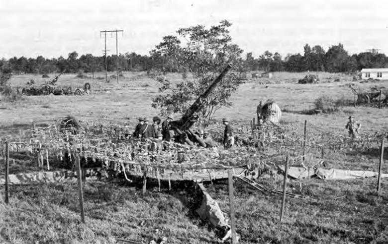
Flat-top concealing 3-inch antiaircraft gun emplacement, 3rd Army maneuver area, Louisiana, August 1941
made from imported jute. Like burlap, osnaburg was also suitable for baling, sandbags, and target cloth. Working in cooperation with the Department of Agriculture, the board developed special impregnants for preventing deterioration and damage to this material by fire, mildew, and rot.44
From 1939 on, the board tested the effects of paints and colors on visibility. Study of terrain throughout the country indicated a need to stock only seven to nine colors. Of these, olive drab promised the widest application under most circumstances. In 1941 the Army applied the information by adopting this color for numerous articles of wood, metal, and cloth. But even with colors that blended with the surroundings, the standard paint had a conspicuous gloss. It was combustible and required turpentine or linseed oil for thinning. After testing a number of commercial products, the board recommended a lusterless casein paint which could be thinned with 50 percent water. It was inexpensive, had good concealment qualities, and reduced fire hazard, but it took several days to become resistant to rain, and when stored outside, froze in winter and turned sour in summer. Since most casein was imported, the board encouraged private industry and the Federation of Paint, Varnish, and Lacquer Production Clubs to seek a substitute. The resulting product was an inexpensive resin-bound cold-water paint which dried rapidly and stored readily.45
Advances in observation techniques meanwhile created a formidable new weapon against camouflage—infra-red photography. Improvements in film now permitted taking infra-red photographs from fast-flying aircraft. With infra-red filters and film, artificial pigments photograph much darker than the green of natural vegetation even though they look the same to the eye. The problem, then, was to get camouflage materials that both visually and photographically matched the colors of nature. The board experimented with cut foliage, which made ideal garnishing except that it withered and required frequent renewal. With help from the Department of Agriculture, some headway was made in preserving cut plants; however, the foliage did not endure outdoors. The board was more successful with infra-red paint. Having no commercial demand, this product did not exist before 1941 and had to be specially developed. The board again profited from research carried out by its own new laboratory and by the paint industry. By the fall of 1941 it was possible to prepare casein and resin-bound paints in standard colors which could not be detected by infra-red photography.
While working on these general problems, the Corps of Engineers also developed special camouflage equipment for other arms. In 1939 Arnold reported on experiments with two-dimensional decoys made from strips of painted cloth which from high altitude resembled silhouettes of aircraft on the ground. By distracting attention from real planes, they would lure the enemy into wasting his efforts and expose him to antiaircraft fire. To simulate shadows, panels of black cloth were placed along the lighter silhouettes. These decoys were partially effective against visual observation at 2,000 feet, but to deceive the aerial camera and to avoid the necessity of moving the shadow panels to correspond with the position of the sun, Arnold suggested elevating the silhouettes onto frames.46
More intensive research on decoys for the AAF as well as other arms came later. So long as troops lacked guns, tanks, and planes for training, it seemed frivolous to talk about using decoys in battle. Thus in August 1941, Maj. Lyle E. Seeman, chief of the camouflage section at the Engineer Board, explained to a display manufacturer: “The subject of elaborate dummies as you outline, would be secondary to placing the real thing in the hands of a man to defend himself. If and when a good bluff will ... be required, and whether that will fall into our responsibility in camouflage work, is a matter of conjecture.”47
Decoys were only incidental to the protection of actual military objects. Concealment of aircraft on the ground depended largely on how effectively the airdromes themselves were concealed. Aviation engineers were trained to pay particular attention to camouflage and dispersion, to disturb the existing terrain as little as possible, to blend the runways with the rest of the landscape, to build repair shops that resembled farm buildings, and to erect flattops and camouflaged sandbag barricades at the edge of the field where dispersed aircraft could be parked. If time permitted,
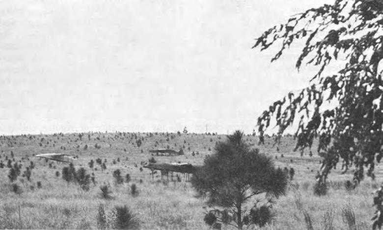
Dummy planes in position, 1st Army maneuver area, October 1941
they would even lay out decoy airdromes to divert the enemy from the real installation.48
Field artillery batteries needed camouflage that could be quickly applied whenever they moved. But flat-tops originally designed for stabilized conditions took a long time to set up. Garnishing the nets themselves was such a slow operation that troops often disregarded concealment altogether or flung bare netting over their parked vehicles and emplacements. Although the board had originally felt it preferable for troops to paint and garnish their own nets to match the local terrain, Saint-Gaudens repeatedly advised simplification of work in the field. It would be overly optimistic to expect troops to bother with elaborate concealment measures in combat; they had not done so in World War I and they would not now, he maintained. The board therefore arranged to furnish precut colored strips of osnaburg as well as nets which were already garnished in three standard blends of colors for different terrains and seasons.49
Even with pregarnished nets, it took hours to dismantle and set up flat-tops for artillery
emplacements. Low trajectory firing left blast marks on the ground, requiring either painstaking precautions or changes in position to avoid detection. Antiaircraft guns were even more troublesome to conceal because they had to be mounted in the open to secure complete traverse and elevation.50
Realizing that modern warfare required faster means of concealment, the board started to revise the artillery frame in January 1941. Saint-Gaudens, just given charge of camouflage at OCE, submitted details about a prefabricated frame for a 30x30-foot net that the British were using. He had seen a crew erect it in eight minutes, and when ready to fire, clear the net from the gun by releasing a switch. After experimenting with various flat-top structures, the board adapted the British model for the 3-inch gun. In place of bulky wooden posts which the old type of flat-top required, the new set used iron pipes which fitted into sockets welded on the outriggers of the gun and which were further secured by guy wires fastened to stakes. Because the British net was too small to conceal both gun and crew, the board added two nets measuring 14x29-feet each. A crew could now camouflage a gun in fifteen to twenty minutes, clear away the net in ten seconds, and reuse the same frame about a hundred times. The principle of knocked-down prefabricated sets was further applied during the war to the concealment of other artillery pieces and even to small aircraft.51
For several years the Engineer Board, upon requests by the infantry, had also investigated the use of small nets for concealing individual soldiers on duty as scouts and snipers. Such nets were helpful so long as soldiers remained motionless but hindered combat activity by catching onto weapons and equipment. Arnold believed it simpler to break the form of the helmet with foliage and to darken the face and hands with dirt.52 Meanwhile reports from abroad described special camouflage suits and helmet covers. In 1940 the board began to experiment with mottled garments which blended with foliage, fields, and grass, and in the fall of 1941 sent samples to the Infantry and Armored Force. At first, adoption of these suits was resisted because they lacked the snappy appearance of regular uniforms. Although the commander of the Hawaiian Department believed that such garments would benefit forces on the beaches or in tropical vegetation, the Chief of Infantry doubted that any “self-respecting Army would wear suits like that.”53 On First Army maneuvers that fall, some lookouts hid their suits rather than bear the taunts of fellow soldiers, but other forward observers that wore them evaded discovery from tanks that passed within a few yards. In December 1941 the Infantry and Armored Force Boards, while recommending changes in tailoring, reported favorably on the idea of camouflage clothing. Special suits of this type were issued during the war, and some troops painted their fatigues in mottled patterns.54
However ingenious these measures were, their value in the last analysis depended upon the using arms. Interest flagged when
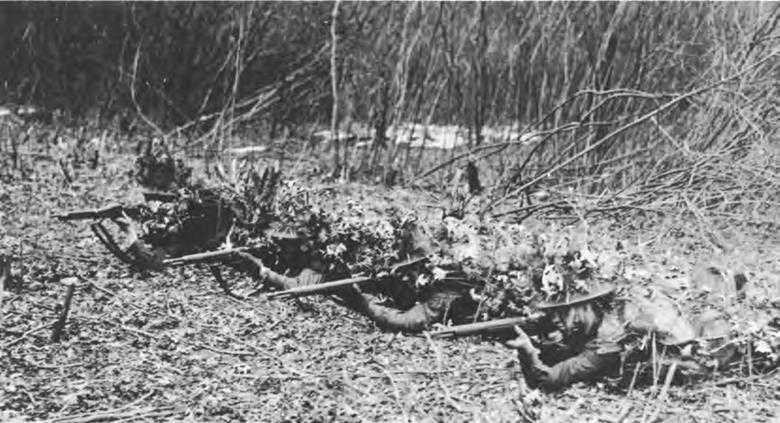
Soldiers camouflaged with individual nets
it was found that camouflage involved work and foresight. Even when natural cover and artificial materials were available, troops on maneuvers generally failed to use them.
They left their nets in cartons, or set them up incorrectly; they concealed against lateral, but not overhead, observation; they double-parked long lines of vehicles bumper-to-bumper; and they failed to observe blackout regulations. No doubt the exaggerated rapidity of operations as well as the virtual absence of aircraft tended to minimize the incentive to camouflage on these exercises. In addition, observance of camouflage in training seemed superfluous to troops who could not sense any immediate and visible danger. What they neglected to practice they expected to apply in battle.
The Engineers knew this type of thinking would result in initial casualties, but so long as camouflage discipline was a command decision, there was little they could do beyond extending the scope of instruction in this subject to the other arms.55